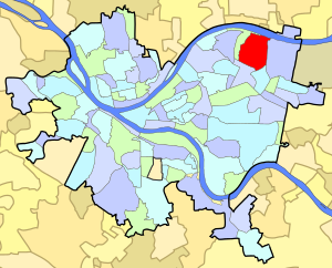
Highland Park is both a large municipalpark and a racially diverse, mostly residential neighborhood in the northeastern part of Pittsburgh, Pennsylvania. Highland Park, the neighborhood, fully encompasses the park.
An urban park or metropolitan park, also known as a municipal park or a public park, public open space, or municipal gardens (UK), is a park in cities and other incorporated places to offer recreation and green space to residents of, and visitors to, the municipality. The design, operation and maintenance is usually done by government agencies, typically on the local level, but may occasionally be contracted out to a park conservancy, friends of group, or private sector company.
A park is an area of natural, semi-natural or planted space set aside for human enjoyment and recreation or for the protection of wildlife or natural habitats. Urban parks are green spaces set aside for recreation inside towns and cities. National parks and Country parks are green spaces used for recreation in the countryside. State parks and Provincial parks are administered by sub-national government states and agencies. Parks may consist of grassy areas, rocks, soil and trees, but may also contain buildings and other artifacts such as monuments, fountains or playground structures. Many parks have fields for playing sports such as soccer, baseball and football, and paved areas for games such as basketball. Many parks have trails for walking, biking and other activities. Some parks are built adjacent to bodies of water or watercourses and may comprise a beach or boat dock area. Urban parks often have benches for sitting and may contain picnic tables and barbecue grills.
Pennsylvania, officially the Commonwealth of Pennsylvania, is a state located in the northeastern and Mid-Atlantic regions of the United States. The Appalachian Mountains run through its middle. The Commonwealth is bordered by Delaware to the southeast, Maryland to the south, West Virginia to the southwest, Ohio to the west, Lake Erie and the Canadian province of Ontario to the northwest, New York to the north, and New Jersey to the east.
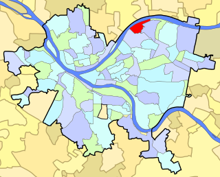
The neighborhood has 6,395 residents according to the 2010 United States Census. It occupies 748 acres (3.03km2) built around the 380-acre (1.5km2) park (also called Highland Park), and is bordered by the neighborhoods of East Liberty and Larimer to the south, Morningside to the west, Lincoln-Lemington-Belmar to the east, and the Allegheny River to the north.
The United States Census is a decennial census mandated by Article I, Section 2 of the United States Constitution, which states: "Representatives and direct Taxes shall be apportioned among the several States ... according to their respective Numbers .... The actual Enumeration shall be made within three Years after the first meeting of the Congress of the United States, and within every subsequent Term of ten Years." Section 2 of the 14th Amendment states: "Representatives shall be apportioned among the several States according to their respective numbers, counting the whole number of persons in each State, excluding Indians not taxed." The United States Census Bureau is responsible for the United States Census. The Bureau of the Census is part of the United States Department of Commerce.
East Liberty is a culturally diverse neighborhood in Pittsburgh, Pennsylvania's East End. It is bordered by Highland Park, Morningside, Stanton Heights, Garfield, Friendship, Shadyside and Larimer, and is represented on Pittsburgh City Council by Councilwoman Deborah Gross and Rev. Ricky Burgess. One of the most notable features in the East Liberty skyline is the East Liberty Presbyterian Church, which is an area landmark.
Larimer is a neighborhood in the East End of the City of Pittsburgh, Pennsylvania in the United States. The neighborhood takes its name from William Larimer, who grew up in nearby Westmoreland County and, after making a fortune in the railroad industry, built a manor house overlooking East Liberty along a path that came to be called "Larimer Lane" and later Larimer Avenue.
The park and the neighborhood are set apart from surrounding areas by Heth's Run, which separates Highland Park from Morningside to the west, and by Negley Run, which separates it from Lincoln-Lemington-Belmar to the east and Larimer to the south. The only direct land routes to Highland Park are from East Liberty, via Negley Avenue, Highland Avenue, and several other streets. The park extends along the northern and eastern borders of the neighborhood, following the Allegheny River and Negley Run.
Morningside is a neighborhood on Pittsburgh, Pennsylvania's East End. It has two zip codes, 15201 and 15206, and has a representation on Pittsburgh City Council by Deb Gross for District 7.
The Park
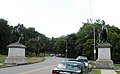
Highland Park (the public park) encompasses the northern region of the neighborhood. Its main entrance is clearly marked by two bronze sculptures by Giuseppe Moretti atop Ionic columns on each side of the Highland Avenue. Its Stanton Avenue entrance features another Moretti pair of sculptures on grand pedestals, depicting two groups of lean, heroic youths taming wild horses.
Giuseppe Moretti was an Italian émigré sculptor who became known in the United States for his public monuments in bronze and marble. Notable among his works is Vulcan in Birmingham, Alabama, which is the largest cast iron statue in the world. On a personal level, Moretti was "known for his eclectic personality and for always wearing a green tie," but professionally, is claimed to be "the first man to use aluminum in art." Moretti enjoyed some celebrity in his lifetime, and was a friend of famed Italian tenor Enrico Caruso. It is even reported that the singer repeatedly praised Moretti's voice.
The Ionic order forms one of the three classical orders of classical architecture, the other two canonic orders being the Doric and the Corinthian. There are two lesser orders: the Tuscan, and the rich variant of Corinthian called the composite order, both added by 16th-century Italian architectural writers, based on Roman practice. Of the three canonic orders, the Ionic order has the narrowest columns.
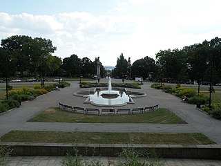
The park, which contains two of the city's large water reservoirs, offers picnic groves, a Babbling Brook water feature, Lake Carnegie for fishing, the city's only long-course swimming pool, four sand volleyball courts, tennis courts, walking trails, and two children's playgrounds (Farmhouse Park and the "Super Playground"). The Pittsburgh Zoo & PPG Aquarium are also within the park, as is the Washington Boulevard Bike Track, a banked half-mile oval loop for bicyclists.
The Pittsburgh Zoo is one of only six major zoo and aquarium combinations in the United States. Located in Pittsburgh, Pennsylvania's Highland Park, the zoo sits on 77 acres (31 ha) of park land where it exhibits more than 4,000 animals representing 475 species, including 20 threatened or endangered species.
The park was founded in 1889, and opened in 1893 after Pittsburgh Director of Public Works, Edward Bigelow, spent more than $900,000 in city funds to buy the land, parcel by parcel, from farmers. In 1898, Bigelow's cousin Christopher Lyman Magee created the Pittsburgh Zoo as an attraction to encourage customers to ride streetcar lines which Magee owned and which ran from East Liberty to Highland Park. A 190-year-old farmhouse, which has been used as a park office and summer campsite, still stands within the park near the "Farmhouse Park" children's playground.
Christopher Lyman Magee was a powerful political boss in Pittsburgh, Pennsylvania, United States. Along with William Flinn (1851–1924), his political partner, the two ran the Republican Party machine that controlled the city for the last twenty years of the 19th century.
The Neighborhood
The first permanent European settler in Highland Park was Alexander Negley, a German settler. In 1778, Negley purchased a 278-acre farm along the Allegheny River that he called “Fertile Bottom” and which extended over much of what is now Highland Park north of Bryant Street. His son Jacob married Barbara Winebiddle, the daughter of other local landowners, in 1795, and in 1799 purchased the 443-acre farm (called “Heth’s Delight”) that adjoined his father’s farm to the south and west. Jacob and Barbara Negley built a brick house at what is now the corner of Stanton and Negley Avenues in 1808, which became the seat of a substantial land holding when the two farms were combined upon the death of Alexander Negley in 1809.
Jacob Negley was one of the most prominent citizens in the early nineteenth century of the East Liberty Valley, the ancient river bottom that lies north of Squirrel Hill in the eastern section of Pittsburgh and provides relief from the generally hilly topography of the city. The earliest highway from the east, the Greensburg & Pittsburgh Turnpike (now Penn Avenue), which followed the line (the Forbes Road) that the British cut during the French and Indian War, ran east–west through the East Liberty Valley. Jacob Negley won the contract to pave a five-mile section of the turnpike between 1813 and 1819. He played a substantial role in the founding of a village in East Liberty, building a steam-powered grist mill on the turnpike in 1816, establishing a bank, and helping to found the East Liberty Presbyterian Church in 1819. His daughter Sara Jane married the lawyer Thomas Mellon, patriarch of the banking family, in 1843.
Upon the death of Jacob Negley in 1827, his widow Barbara built a new farmhouse for herself in 1829, which still stands and which gives its name to the "Farmhouse Park" playground within Highland Park. She also resolved certain debts that she and Jacob had incurred during the Panic of 1819 by selling some parcels of her land. In 1837, Barbara Winebiddle Negley divided the remainder of the estate among her children. This started the process of subdivision of land in East Liberty and Highland Park that led to the development of those neighborhoods in the later nineteenth century. With the subdivision of the estate, the County Surveyor, Robert Hilands, also laid out the first streets in the Highland Park area. He formally established Negley Avenue along the line of the country lane that connected Penn Avenue with the Negley homestead, laid out Hiland Avenue (named after himself until changed to “Highland” by the City in 1890) as the principal street running north out of the center of the village of East Liberty, and converted the Negleys’ principal east–west “Country Lane” into what is now called Stanton Avenue.
In the first half of the nineteenth century, most of the development in the East End of Pittsburgh occurred in the East Liberty section. This growth was spurred on by the construction of the Pennsylvania Railroad’s main line to Pittsburgh through the East Liberty Valley in 1852. By 1868, there was a population of about 5000 in the general vicinity of East Liberty. In that year, the municipalities east of Pittsburgh (the townships of Pitt, Peebles, Liberty, Collins and Oakland, and the borough of Lawrenceville) were annexed by the City of Pittsburgh as part of a campaign of expansion that tripled the size of the city and extended its boundaries south of the Monongahela River. Further transportation improvements followed the incorporation of East Liberty into the city. In 1870, the City Councils passed the Penn Avenue Act, which provided a mechanism for the paving of local streets, and in 1872 horse-drawn streetcar service was extended out of Pittsburgh to East Liberty. In addition, the city Water Commission purchased land and began construction in 1872 of a reservoir on the top of the hill at the head of Hiland Avenue that opened in 1879. The land purchases for the reservoir later provided the germ of the Highland Park landscape park that was founded in 1889.
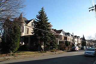
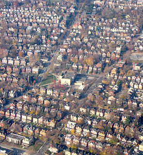
The Highland Park neighborhood was developed as a streetcar suburb: residents walked or used streetcars to reach East Liberty, where they worked, shopped, or took trains to other portions of the City of Pittsburgh. As such, the neighborhood was initially almost wholly residential, with homes that are in many cases quite substantial. These homes are spaced further apart than the rowhouses of fully urban neighborhoods such as Bloomfield and Lawrenceville, but they are much closer together than is typical in a post-1940s automobile suburb. The Highland Park neighborhood's appeal derived (and still derives) in large part from its setting between the large public park to the north and the East Liberty business district to the south. That appeal declined to some extent from 1970–2000, when East Liberty went through an extended period of decline, but East Liberty's renaissance as a commercial district after 2000 has caused the Highland Park neighborhood to become more appealing as well.
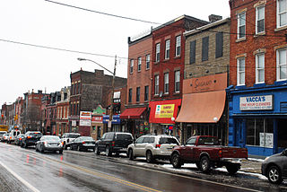
Due in part to the aforementioned decline of East Liberty, the Highland Park neighborhood developed a very small business district of its own on Bryant Street, which presently includes a number of restaurants, a neighborhood grocer, a bakery, a coffee shop, an automobile repair facility, and several other small businesses that are interspersed among private residences on Bryant Street. While no streetcars run through the present-day Highland Park neighborhood, it is served by several bus routes which run south to East Liberty and then beyond.
Historic District
On August 30, 2007, the Highland Park Residential Historic District was officially listed on the National Register of Historic Places.[2] The historic district encompasses the entire neighborhood of Highland Park: its western border consists of Chislett Street (from Stanton Avenue on the south to Hampton Street on the north) and Heth's Run (or more specifically, King Avenue and Cordova Street, which are just to the east of Heth's Run). Its southern and eastern border consists of Stanton Avenue, and its northern border is the Allegheny River.[3] Academy Award winning actor, Gene Kelly, and acclaimed jazz singer, Billy Eckstine, were both born and raised here.
Greenfield is a neighborhood in Pittsburgh, Pennsylvania, United States. It is represented on Pittsburgh City Council by Corey O'Connor.
Downtown Pittsburgh, colloquially referred to as the Golden Triangle, and officially the Central Business District, is the urban downtown center of Pittsburgh. It is located at the confluence of the Allegheny River and the Monongahela River whose joining forms the Ohio River. The "triangle" is bounded by the two rivers. The area features offices for major corporations such as PNC Bank, U.S. Steel, PPG, Bank of New York Mellon, Heinz, Federated Investors and Alcoa. It is where the fortunes of such industrial barons as Andrew Carnegie, Henry Clay Frick, Henry J. Heinz, Andrew Mellon and George Westinghouse were made. It contains the site where the French fort, Fort Duquesne, once stood.
Bloomfield is a neighborhood in Pittsburgh, Pennsylvania. It is located three miles from the downtown area. Bloomfield is sometimes referred to as Pittsburgh's Little Italy because it was settled by Italians from the Abruzzi region and has been a center of Italian–American population. Pittsburgh architectural historian, Franklin Toker, has said that Bloomfield "is a feast, as rich to the eyes as the homemade tortellini and cannoli in its shop windows are to the stomach." Recently, neighborhood has as attracted young adults and college students as a "hip" neighborhood.
Friendship is a neighborhood of large Victorian houses in the East End of the City of Pittsburgh, Pennsylvania, United States, about four miles (6 km) east of Pittsburgh's Golden Triangle. Friendship is bordered on the north by Garfield, on the east by East Liberty, on the south by Shadyside, and on the west by Bloomfield. It is divided into 3 Pittsburgh City Council districts.
Lincoln–Lemington–Belmar is a neighborhood in Pittsburgh, Pennsylvania. It is located in the northeastern section of the city and spans the Allegheny River. The Pittsburgh Bureau of Fire houses 15 Engine in the Lincoln–Lemington–Belmar section of the city.
Brookline is a neighborhood in Pittsburgh, Pennsylvania in the United States.
Garfield is a neighborhood in the East End of the City of Pittsburgh, Pennsylvania, United States. Garfield is bordered on the South by Bloomfield and Friendship, on the West by the Allegheny Cemetery, on the North by Stanton Heights, and on the East by East Liberty. Like many parts of Pittsburgh, Garfield is a fairly steep neighborhood, with north-south residential streets running at about a 20% incline from Penn Avenue at the bottom to Mossfield Street at the top. Garfield is divided into “the valley” and “the hilltop.”
Central Lawrenceville is a neighborhood in the northeast of Pittsburgh, Pennsylvania in the United States. It has a zip code of 15201, and has representation on Pittsburgh City Council by the council member for District 7. It is home to Allegheny Cemetery. Central Lawrenceville is the home of the Pittsburgh Bureau of Fire's 6 Engine and 6 Truck.
East Allegheny, also known as Deutschtown, is a neighborhood on Pittsburgh's North Side. It has a ZIP Code of 15212, and has representation on Pittsburgh City Council by the council member for District 1. The Pittsburgh Bureau of Fire houses 32 Engine and 32 Truck in Deutschtown.
Lawrenceville is one of the largest neighborhood areas in Pittsburgh in the U.S. state of Pennsylvania. It is located northeast of downtown, and like many of the city's riverfront neighborhoods, it has an industrial past. The city considers Lawrenceville three neighborhoods, Upper Lawrenceville, Central Lawrenceville, and Lower Lawrenceville, but these distinctions have little practical effect. Accordingly, Lawrenceville is almost universally treated as being a single large neighborhood.
Marshall-Shadeland is a neighborhood on Pittsburgh, Pennsylvania's North Side. It has a zip codes of both 15212 and 15214, and has representation on Pittsburgh City Council by the council member for District 1.
Shadyside is a neighborhood in the East End of Pittsburgh, Pennsylvania, United States. It has three zip codes and representation on Pittsburgh City Council by the council member for District 8. Shadyside is drawn from the name of a 19th-century Pennsylvania Railroad station in the area, which was named for its shady lanes.
Stanton Heights is a neighborhood in Pittsburgh, Pennsylvania's east city area. It has zip codes of both 15201 and 15206, and has representation on Pittsburgh City Council by the council member for District 7. Stanton Heights is the home of the Pittsburgh bureau of Fire's 7 engine. 7 engine runs most of their calls assisting 6 engine/truck in Lawrenceville and 8 engine/truck in East Liberty.
West End Village is a neighborhood in Pittsburgh, Pennsylvania's west city area. It has a zip code of 15220, and has representation on Pittsburgh City Council by the council member for District 2.
Perry South is a neighborhood on Pittsburgh, Pennsylvania's North Side.
Highland Park is a large municipal park in the northeastern part of Pittsburgh, Pennsylvania. It is located in Pittsburgh's Highland Park neighborhood. The park extends along the northern and eastern borders of the neighborhood, following the Allegheny River and Negley Run.
This page is based on this Wikipedia article Text is available under the CC BY-SA 4.0 license; additional terms may apply. Images, videos and audio are available under their respective licenses.