Jitarning

Last updated

Jitarning
Jitarning Hall, 2014(2).JPG
Jitarning Hall, 2014
Australia Western Australia location map.svg
Red pog.svg
Jitarning
Jitarning
Interactive map of Jitarning
Coordinates: 32.7859°0′S117.9966°0′E / 32.786°S 117.997°E / -32.786; 117.997
Country Australia
State Western Australia
LGA
Location
  • 257.7 km (160.1 mi) SE of Perth
Established1917
Area
 • Total
439.9 km2 (169.8 sq mi)
Elevation
342 m (1,122 ft)
Population
 • Total72
 • Density0.1637/km2 (0.4239/sq mi)
Postcode
6365

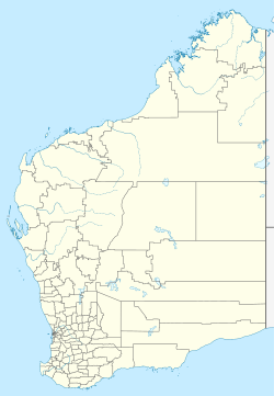
Jitarning is a locality in the Shire of Kulin in Western Australia, with a population of 63 according to the 2021 Census. [1]

Contents

Location

Jitarning is located approximately 22km south of the town of Kulin.

History

Michael Brown, founder of the Narrogin Road Board and the Narrogin Flour Mills, took up a pastoral lease and established a base camp at Jitarning (formerly Geetaring) soak. The presence of the nearby water sources drew in settlers and future residents. Jitarning was gazetted in 1917 [2] after the construction of the Merredin to Yilliminning railway line connected the small settlement. [3]

An inability to get a liquor licence hindered Jitarning's development into a small town; the neighbouring Kulin's hotel had a licence, so it outcompeted Jitaring, causing Kulin's continual development and hindering Jitarning's growth. [3]

References

  1. ↑ "2021 Jitarning, Census All persons QuickStats | Australian Bureau of Statistics". abs.gov.au. Retrieved 10 October 2023.
  2. ↑ "Jitarning » Visit Kulin". www.visitkulin.com.au. Retrieved 10 October 2023.
  3. 1 2 "Heritage Council of WA - Places Database". inherit.stateheritage.wa.gov.au. Retrieved 10 October 2023.