La Colorada, Mexico

Last updated

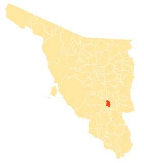
La Colorada is a small town in La Colorada Municipality in the Mexican state of Sonora. In 2005, the population of the municipality was 1,754, with 288 living in the municipal seat. [1] Formerly known as Minas Prietas, La Colorada became a municipality on June 28, 1934. [2] As an important mining camp in Mexico, La Colorada boasted a population that topped 5,604 in 1895. [3] The municipality is situated 45 km (29 mi) southeast of Hermosillo. [4]

La Colorada Municipality is a municipality in Sonora in north-western Mexico.

Mexico Country in the southern portion of North America

Mexico, officially the United Mexican States, is a country in the southern portion of North America. It is bordered to the north by the United States; to the south and west by the Pacific Ocean; to the southeast by Guatemala, Belize, and the Caribbean Sea; and to the east by the Gulf of Mexico. Covering almost 2,000,000 square kilometres (770,000 sq mi), the nation is the fifth largest country in the Americas by total area and the 13th largest independent state in the world. With an estimated population of over 120 million people, the country is the eleventh most populous state and the most populous Spanish-speaking state in the world, while being the second most populous nation in Latin America after Brazil. Mexico is a federation comprising 31 states and Mexico City, a special federal entity that is also the capital city and its most populous city. Other metropolises in the state include Guadalajara, Monterrey, Puebla, Toluca, Tijuana and León.

Sonora State of Mexico

Sonora, officially Estado Libre y Soberano de Sonora, is one of 31 states that, with Mexico City, comprise the 32 federal entities of United Mexican States. It is divided into 72 municipalities; the capital city is Hermosillo. Sonora is bordered by the states of Chihuahua to the east, Baja California to the northwest and Sinaloa to the south. To the north, it shares the U.S.–Mexico border with the states of Arizona and New Mexico, and on the west has a significant share of the coastline of the Gulf of California.

Other small towns located within the municipality include Tecorípa, Cobachi, Estación Torres, and San José de Pimas.[ citation needed ]

Estación Torres is a small town in the Mexican state of Sonora. At the turn of the twentieth century, Estación Torres and nearby Minas Prietas formed the "greatest mining camp in northwest Mexico." The town developed rapidly due to foreign investment and its location along the Sonoran railroad, but it soon declined in the early twentieth century. In 2005, the population of the town was 178.

Related Research Articles

Nogales, Sonora City in Sonora, Mexico

Heroica Nogales, more commonly known as Nogales, is a city and the county seat of the Municipality of Nogales. It is located on the northern border of the Mexican state of Sonora. The city is abutted on its north by the city of Nogales, Arizona, across the U.S.-Mexico border.

Guaymas city in Sonora, Mexico

Guaymas is a city in Guaymas Municipality, in the southwest part of the state of Sonora, in northwestern Mexico. The city is 117 km south of the state capital of Hermosillo, and 242 miles from the U.S. border. The municipality is located on the Gulf of California and the western edge of the Sonoran Desert and has a hot, dry climate and 117 km of beaches. The municipality’s formal name is Guaymas de Zaragoza and the city’s formal name is the Heróica Ciudad de Guaymas.

Empalme is a city surrounded by a municipality located on the south-central coast of the Mexican state of Sonora. According to the 2005 census the population of the city was 40,630 inhabitants, while the municipality, which has an area of 708.53 km², reported 50,663 inhabitants. Except for its coastline on the Gulf of California, the municipality is entirely surrounded by the much larger municipality of Guaymas.

Cananea Municipality Municipality in Sonora, Mexico

Cananea is a municipality in the northern portion of the Mexican state of Sonora, on the U.S. border. Its municipal seat is the city of Cananea, located at 30°58′55″N110°18′02″W.

Arizpe Place

Arizpe is a small town in Arizpe Municipality in the north of the Mexican state of Sonora. It is located at 30°20'"N 110°09'"W. The area of the municipality is 2,806.78 sq.km. The population in 2005 was 2,959 of which 1,743 lived in the municipal seat as of the 2000 census.

Bacoachi village in Sonora, Mexico

Bacoachi is a small town in Bacoachi Municipality in the north of the Mexican state of Sonora. The area of the municipality is 487 square miles (1,260.65 km²) and the population was 1,456 in 2005, with 924 inhabitants residing in the municipal seat. The elevation of the municipal seat is 4,429 feet above sea level.

Bácum village in Sonora, Mexico

Bácum is a small city and the county seat of Bácum Municipality, located in the south of the Mexican state of Sonora at 27°32′N110°05′W.

Banámichi is a small town in Banámichi Municipality in the north of the Mexican state of Sonora. Geographical coordinates are 30°01′N110°13′W.

Baviácora is a small town and the municipal seat of the surrounding municipality of the Mexican state of Sonora. The geographical coordinates are 29°42′N110°09′W.

San Felipe de Jesús is the municipal seat of San Felipe de Jesús Municipality in the center of the Mexican state of Sonora. It is named after Mexico's first saint and Franciscan martyr, executed by Japanese shogun Toyotomi Hideyoshi.

Eloxochitlán de Flores Magón Municipality and town in Oaxaca, Mexico

Eloxochitlán de Flores Magón, formerly known as San Antonio Eloxochitlán, is a city and municipality in the Mexican state of Oaxaca. It is part of the Teotitlán District in the north of the Cañada Region. Approximately 96% of the inhabitants of the municipality speak the indigenous Tecóatl Mazatec.

Yécora, Sonora Municipality in Sonora, Mexico

Yécora is a small town, and its surrounding municipality of the same name, in the Mexican state of Sonora, located at Latitude = 28.3710, Longitude = -108.9269 with an elevation of 5,173 feet. The town is bordered on the east by the state of Chihuahua, to the north by the municipalities of Sahuaripa and Southeast Rosario, to the west by the municipality Suaqui Grande, and the northwest by the municipality of Onavas. Yécora has an area of 1,279 square miles, accounting for 1.79 percent of total state. An approximate population for Yécora is 317.

Bácum Municipality Municipality in Sonora, Mexico

Bácum Municipality is a municipality of southwestern Sonora, in northwestern Mexico. The population was 21,322 in 2005.

Hermosillo Municipality Municipality in Sonora, Mexico

Hermosillo is a municipality in Sonora in north-western Mexico. The municipal seat is the city of Hermosillo.

Mazatán Municipality is a municipality in Sonora in north-western Mexico.

Nogales Municipality, Sonora Municipality in Sonora, Mexico

The Municipality of Nogales is a municipality of northern Sonora state, in Northwestern Mexico.

Quiriego Municipality Municipality in Sonora, Mexico

Quiriego Municipality is a municipality of southern Sonora state, in northwestern Mexico.

San Javier Municipality, Sonora Municipality in Sonora, Mexico

San Javier Municipality is a municipality in Sonora in north-western Mexico. As of 2015, the municipality had a total population of 557.

Soyopa Municipality is a municipality in Sonora in north-western Mexico.

References

  1. Instituto Nacional de Estadística, Geografía e Informática (INEGI) Archived 2013-02-27 at WebCite
  2. Pueblos de Sonora Archived 2007-06-09 at the Wayback Machine .
  3. Miguel Tinker-Salas: In the Shadow of the Eagles: Sonora and the Transformation of the Border during the Porfiriato (Berkeley, Calif.: University of California Press, 1997). page 181.
  4. La Colorada

Coordinates: 28°48′00″N110°34′00″W / 28.80000°N 110.56667°W / 28.80000; -110.56667

Geographic coordinate system Coordinate system

A geographic coordinate system is a coordinate system that enables every location on Earth to be specified by a set of numbers, letters or symbols. The coordinates are often chosen such that one of the numbers represents a vertical position and two or three of the numbers represent a horizontal position; alternatively, a geographic position may be expressed in a combined three-dimensional Cartesian vector. A common choice of coordinates is latitude, longitude and elevation. To specify a location on a plane requires a map projection.