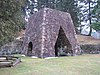
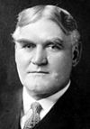
Marker title Image Date dedicated Location Marker type Topics Admiral Wm. Sims April 23, 1995 Pa. 994 in Rockville, W of U.S. 522 40°14′18″N 77°54′06″W / 40.2382°N 77.90167°W / 40.2382; -77.90167 (Admiral Wm. Sims ) Roadside Military, Military Post-Civil War Bedford Furnace April 28, 1947 US 522, at SE end of Orbisonia Roadside Business & Industry, Coal, Furnaces, Iron Coleraine Forges April 30, 1947 Pa. 45, 1.6 miles NE of Spruce Creek 40°37′38″N 78°06′51″W / 40.6272°N 78.11406°W / 40.6272; -78.11406 (Coleraine Forges ) Roadside Business & Industry, Coal, Iron David R. Porter October 15, 1955 3rd & Penn Sts., Huntingdon 40°29′02″N 78°00′32″W / 40.48378°N 78.00891°W / 40.48378; -78.00891 (David R. Porter ) City Government & Politics, Government & Politics 19th Century, Governors, Professions & Vocations Fort Roberdeau April 30, 1947 Pa. 453 & Truck Pa. 45 just S of Union Furnace (MISSING) 40°36′35″N 78°10′08″W / 40.60975°N 78.16875°W / 40.60975; -78.16875 (Fort Roberdeau ) Roadside American Revolution, Forts, Military Fort Shirley April 25, 1947 U.S. 522 at N end Shirleysburg 40°18′06″N 77°52′27″W / 40.30174°N 77.87404°W / 40.30174; -77.87404 (Fort Shirley ) Roadside Forts, French & Indian War, Military Fort Shirley - PLAQUE May 1, 1926 US 522, Shirleysburg 40°18′05″N 77°52′28″W / 40.30131°N 77.87431°W / 40.30131; -77.87431 (Fort Shirley - PLAQUE ) Plaque Forts, French & Indian War, Military Fort Standing Stone October 15, 1955 Penn St., Huntingdon 40°28′54″N 78°00′15″W / 40.48162°N 78.00411°W / 40.48162; -78.00411 (Fort Standing Stone ) Roadside American Revolution, Forts, Military, Native American Frankstown Path March 16, 1949 US 22 at Water Street, PA (town name) 40°34′15″N 78°08′03″W / 40.57096°N 78.13425°W / 40.57096; -78.13425 (Frankstown Path ) Roadside Paths & Trails, Transportation Greenwood Furnace April 30, 1947 Pa. 305 at Greenwood Furnace State Park 40°38′57″N 77°45′25″W / 40.64903°N 77.75705°W / 40.64903; -77.75705 (Greenwood Furnace ) Roadside Business & Industry, Furnaces, Iron Hart's Log March 16, 1946 PA 305 at US22 junction, just S of Alexandria 40°33′27″N 78°05′57″W / 40.55737°N 78.0993°W / 40.55737; -78.0993 (Hart's Log ) Roadside Early Settlement, Paths & Trails, Professions & Vocations, Transportation Huntingdon County September 20, 1982 County Courthouse, Penn St., Huntingdon 40°29′01″N 78°00′29″W / 40.48364°N 78.00813°W / 40.48364; -78.00813 (Huntingdon County ) City Government & Politics, Government & Politics 18th Century Jack's Narrows June 6, 1946 U.S. 22, 8.5 miles SE of Huntingdo (Missing) Roadside Environment Juniata Iron April 29, 1947 U.S. 522, 1 mile S of Orbisonia Roadside Business & Industry, Coal, Iron Juniata Iron April 29, 1947 U.S. 22 just E of Water Street 40°34′15″N 78°08′02″W / 40.57088°N 78.13396°W / 40.57088; -78.13396 (Juniata Iron ) Roadside Business & Industry, Coal, Iron Martin G. Brumbaugh July 1, 1949 Pa. 26, 1.3 miles NE of Marklesburg 40°23′49″N 78°08′56″W / 40.39705°N 78.1488°W / 40.39705; -78.1488 (Martin G. Brumbaugh ) Roadside Education, Government & Politics, Government & Politics 20th Century, Governors Martin G. Brumbaugh July 23, 1948 US 22 & PA 26, W of Huntingdon 40°29′31″N 78°02′24″W / 40.49208°N 78.04007°W / 40.49208; -78.04007 (Martin G. Brumbaugh ) Roadside Education, Governors, Professions & Vocations McAlevy's Fort n/a Junction Pa. 305 & Pa. 545 at McAlevy's Fort (Missing) Roadside American Revolution, Military McMurtrie Mansion October 15, 1955 4th & Penn. Huntingdon 40°29′04″N 78°00′38″W / 40.48447°N 78.01069°W / 40.48447; -78.01069 (McMurtrie Mansion ) City Buildings, Mansions & Manors Pennsylvania Furnace April 30, 1947 Spruce Creek Rd. (PA 45) at Pennsylvania Furnace Rd., PA Furnace 40°42′06″N 77°59′58″W / 40.70172°N 77.99935°W / 40.70172; -77.99935 (Pennsylvania Furnace ) Roadside Business & Industry, Coal, Furnaces, Iron Rural Electrification July 5, 1992 10700 Fairgrounds Rd., Huntingdon 40°30′34″N 77°58′44″W / 40.5094°N 77.97878°W / 40.5094; -77.97878 (Rural Electrification ) Roadside Business & Industry, Electricity Shadow of Death April 28, 1947 Croghan Pike (US 522) W of Shade Gap 40°11′19″N 77°52′32″W / 40.18869°N 77.87561°W / 40.18869; -77.87561 (Shadow of Death ) Roadside Paths & Trails, Transportation Spruce Creek Church April 21, 1949 Spruce Creek Rd. (PA 45) at church, just NE of Graysville 40°41′27″N 78°17′17″W / 40.69087°N 78.288°W / 40.69087; -78.288 (Spruce Creek Church ) Roadside Religion