Cape Cod is a peninsula extending into the Atlantic Ocean from the southeastern corner of Massachusetts, in the northeastern United States. Its historic, maritime character and ample beaches attract heavy tourism during the summer months. The name Cape Cod, coined in 1602 by Bartholomew Gosnold, is the ninth oldest English place-name in the U.S.
The Cape Cod National Seashore (CCNS) encompasses 43,607 acres on Cape Cod, in Massachusetts. CCNS was created on August 7, 1961, by President John F. Kennedy, when he signed a bill enacting the legislation he first co-sponsored as a Senator a few years prior. It includes ponds, woods and beachfront of the Atlantic coastal pine barrens ecoregion. The CCNS includes nearly 40 miles (64 km) of seashore along the Atlantic-facing eastern shore of Cape Cod, in the towns of Provincetown, Truro, Wellfleet, Eastham, Orleans and Chatham. It is administered by the National Park Service.

Provincetown is a New England town located at the extreme tip of Cape Cod in Barnstable County, Massachusetts, in the United States. A small coastal resort town with a year-round population of 3,664 as of the 2020 United States Census, Provincetown has a summer population as high as 60,000. Often called "P-town" or "Ptown", the locale is known as a vacation destination for its beaches, harbor, artists and tourist industry.

Wellfleet is a town in Barnstable County, Massachusetts, United States, and is located halfway between the "tip" and "elbow" of Cape Cod. The town had a population of 3,566 at the 2020 census, which swells nearly sixfold during the summer. A total of 70% of the town's land area is under protection, and nearly half of it is part of the Cape Cod National Seashore. Wellfleet is famous for its oysters, which are celebrated in the annual October Wellfleet OysterFest.

Barnstable County is a county located in the U.S. state of Massachusetts. At the 2020 census, the population was 228,996. Its county seat is Barnstable. The county consists of Cape Cod and associated islands.
Eastham is a town in Barnstable County, Massachusetts, United States, Barnstable County being coextensive with Cape Cod. The population was 5,752 at the 2020 census.

Truro is a town in Barnstable County, Massachusetts, United States, comprising two villages: Truro and North Truro. Located slightly more than 100 miles (160 km) by road from Boston, it is a summer vacation community just south of the northern tip of Cape Cod, in an area known as the "Outer Cape". English colonists named it after Truro in Cornwall, United Kingdom.

Brewster is a town in Barnstable County, Massachusetts, United States, Barnstable County being coextensive with Cape Cod. The population of Brewster was 10,318 at the 2020 census.

Chatham is a town in Barnstable County, Massachusetts, United States. Chatham is located at the southeastern tip of Cape Cod and has historically been a fishing community. First settled by the English in 1664, the township was originally called Monomoit based on the indigenous population's term for the region. Chatham was incorporated as a town on June 11, 1712, and has become a summer resort area. The population was 6,594 at the 2020 census and can swell to 25,000 during the summer months. There are four villages that comprise the town, those being Chatham (CDP), South Chatham, North Chatham, and West Chatham. Chatham is home to the Monomoy National Wildlife Refuge and the decommissioned Monomoy Point Light, both located on Monomoy Island. A popular attraction is the Chatham Light, which is an operational lighthouse that is operated by the United States Coast Guard.

Orleans is a town in Barnstable County, Massachusetts, United States, situated along Cape Cod. The population was 6,307 at the 2020 census.

Dennis is a town in Barnstable County, Massachusetts, United States, located near the center of Cape Cod. The population was 14,674 at the 2020 census.

The Cape Cod Rail Trail (CCRT) is a 25.5-mile (41.0 km) paved rail trail located on Cape Cod in Massachusetts. The trail route passes through the towns of Yarmouth, Dennis, Harwich, Brewster, Orleans, Eastham, and Wellfleet. It connects to the 6-plus mile (10 km) Old Colony Rail Trail leading to Chatham, the 2 mile Yarmouth multi-use trail, and 8 miles (13 km) of trails within Nickerson State Park. Short side trips on roads lead to national seashore beaches including Coast Guard Beach at the end of the Nauset Bike Trail in Cape Cod National Seashore. The trail is part of the Claire Saltonstall Bikeway.
Pleasant Bay is a bay of the Atlantic Ocean just north of the "elbow" of Cape Cod in Massachusetts. It is bounded on the east by a long peninsula and a barrier island, and harbors 7,825 acres (31.67 km2) of saltwater when the tide is in.

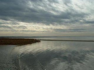
The Nauset Archaeological District is a National Historic Landmark District in Eastham, Massachusetts. Located within the southern portion of the Cape Cod National Seashore, this area was the location of substantial ancient settlements since at least 4,000 BC.
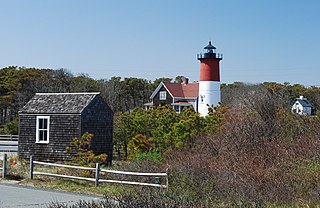
The French Cable Hut is a historic building in Cape Cod National Seashore, near the Nauset Beach Light in Eastham, Massachusetts. Built in 1891, the hut formed a linkage point in the transatlantic telegraph cable of the French Cable Company connecting the cable, where it came ashore near the present site to its main station in Orleans. After the cable was abandoned in 1932, the hut was adapted for residential use. It has since been restored to its turn-of-the-century appearance by the National Park Service. The building was listed on the National Register of Historic Places in 1976.
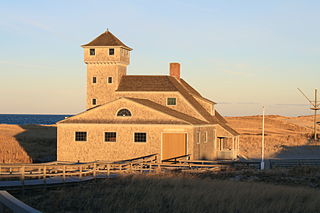
The Old Harbor U.S. Life Saving Station is a historic maritime rescue station and museum, located at Race Point Beach in Provincetown, Massachusetts. Built in 1897, it was originally located at Nauset Beach near the entrance to Chatham Harbor in Chatham, Massachusetts. It was used by the United States Life-Saving Service (USLSS), and then by its successor, the United States Coast Guard (USCG), as the Old Harbor Coast Guard Station. The station was decommissioned in 1944, abandoned and sold as surplus in 1947, and was used as a private residence for the next twenty-six years.

Nepean Bay is a bay located on the north-east coast of Kangaroo Island in the Australian state of South Australia about 130 kilometres south-south-west of Adelaide. It was named by the British navigator, Matthew Flinders, after Sir Evan Nepean on 21 March 1802.
Coast Guard Beach is part of the Cape Cod National Seashore in Eastham, Massachusetts. From mid-June to Labor Day, the parking area at this location is closed to all but park staff and visitors who are disabled, and access is provided by shuttle bus from the Little Creek parking area. Although the parking lot at Coast Guard Beach is open the remainder of the year, parking is limited. There are seasonal restrooms and a wheelchair-accessible rampway to the beach.