List of settlements in Greater Manchester by population

Last updated

Greater Manchester UK location map 2.svg
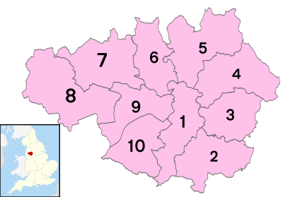
The 26 largest settlements of the county of Greater Manchester, with cities in bold, district centres in yellow, and key towns and areas in white.

This is a list of settlements in Greater Manchester by population based on the results of the 2011 census. The next United Kingdom census will take place in 2021. In 2011, there were 61 built-up area subdivisions with 5,000 or more inhabitants in Greater Manchester, shown in the table below.

Contents

Administrative boundaries

Greater Manchester numbered districts.svg

Table taken from the Greater Manchester article:

Metropolitan countyMetropolitan districtCentre of administrationOther components
Greater Manchester1 Manchester GreaterManchesterManchester.png Manchester
(City Centre)
Blackley, Burnage, Cheetham Hill, Chorlton-cum-Hardy, Didsbury, Ringway, Withington, Wythenshawe
2 Stockport GreaterManchesterStockport.png Stockport Bramhall, Bredbury, Cheadle, Gatley, Hazel Grove, Marple, Reddish, Romiley
3 Tameside GreaterManchesterTameside.png Ashton-under-Lyne Audenshaw, Denton, Droylsden, Dukinfield, Hyde, Longdendale, Mossley, Stalybridge
4 Oldham GreaterManchesterOldham.png Oldham Chadderton, Shaw and Crompton, Failsworth, Lees, Royton, Saddleworth
5 Rochdale GreaterManchesterRochdale.png Rochdale Heywood, Littleborough, Middleton, Milnrow, Newhey, Wardle
6 Bury GreaterManchesterBury.png Bury Prestwich, Radcliffe, Ramsbottom, Tottington, Whitefield
7 Bolton GreaterManchesterBolton.png Bolton Blackrod, Farnworth, Horwich, Kearsley, Little Lever, South Turton, Westhoughton
8 Wigan GreaterManchesterWigan.png Wigan Abram, Ashton-in-Makerfield, Aspull, Astley, Atherton, Bryn, Golborne, Higher End, Hindley, Ince-in-Makerfield, Leigh, Orrell, Standish, Shevington, Tyldesley, Winstanley
9 Salford GreaterManchesterSalford.png Swinton Eccles, Walkden, Worsley, Salford, Irlam, Pendlebury, Cadishead
10 Trafford GreaterManchesterTrafford.png Stretford Altrincham, Bowdon, Hale, Old Trafford, Sale, Urmston

Population ranking

#SettlementPopulation [1]
Census 2001Census 2011
1 Manchester (see notes)405,300510,746
2 Bolton 182,980194,189
3 Sale 122,990134,022
4 Rochdale 102,080107,926
5 Stockport 106,170105,878
6 Salford 88,460103,886
7 Wigan 98,480103,608
8 Oldham 103,54496,555
9 Bury 74,54077,211
10 Leigh/Atherton 65,98070,542
11 Altrincham 46,46052,419
12 Ashton-under-Lyne 43,24045,198
13 Middleton 42,62542,972
14 Urmston 41,26341,825
15 Eccles 37,86138,756
16 Denton 36,87736,591
17 Chadderton 33,00034,818
18 Romiley 34,92634,696
19 Hyde 31,61034,003
20 Radcliffe 28,96029,950
21 Ashton-in-Makerfield 28,85628,762
22 Heywood 28,33028,205
23 Farnworth 25,67726,939
24 Stretford 24,84226,813
25 Stalybridge 24,90026,482
26 Swinton 25,04625,362
27 Hindley 22,92024,497
28 Cheadle Hulme 24,49524,362
29 Golborne 23,11924,167
30 Droylsden 24,17024,134
31 Westhoughton 22,19024,126
32 Royton 23,67023,812
33 Walkden 20,84721,194
34 Gatley 20,58320,997
35 Whitefield 20,87720,975
36 Dukinfield 20,50720,909
37 Irlam 19,02019,933
38 Horwich 18,61019,492
39 Hazel Grove 19,15319,365
40 Failsworth 19,27918,844
41 Shaw 19,33518,815
42 Marple 18,74218,241
43 Ramsbottom 17,90017,872
44 Bramhall 17,74717,436
45 Hale 15,31616,624
46 Tyldesley 15,58316,142
47 Standish 13,58013,701
48 Cheadle 13,37413,467
49 Uppermill 12,64713,448
50 Lees 12,60013,062
51 Little Lever 12,57012,803
52 Littleborough 12,26012,370
53 Ince-in-Makerfield 10,68012,243
54 Kearsley 10,46011,150
55 Mossley 9,71010,772
56 Platt Bridge/Abram 9,01010,315
57 Milnrow 9,89610,015
58 Worsley 9,4659,108
59 Partington 7,3277,912
60 Shevington Vale/Appley Bridge

(see notes below)

5,1555,197
61 Shevington 5,2925,114
62 Aspull 4,9774,899
63 Hattersley 4,7774,825
64 High Lane 4,7724,608
65 Blackrod 4,9754,548

Notes:

See also

Related Research Articles

Metropolitan Borough of Rochdale Borough of Greater Manchester, England

The Metropolitan Borough of Rochdale is a metropolitan borough of Greater Manchester in North West England. It is named after its largest town, Rochdale, The borough covers other outlying towns and villages with a population of 206,500 at the 2011 census. It is the ninth-largest district by population in Greater Manchester.

Demography of England Overview of the demography of England

The demography of England has since 1801 been measured by the decennial national census, and is marked by centuries of population growth and urbanization. Due to the lack of authoritative contemporary sources, estimates of the population of England for dates prior to the first census in 1801 vary considerably.

Ashton-under-Lyne Market town in the Metropolitan Borough of Tameside, Greater Manchester, England

Ashton-under-Lyne is a market town in Tameside, Greater Manchester, England. The population was 45,198 at the 2011 census. Historically in Lancashire, it is on the north bank of the River Tame, in the foothills of the Pennines, 6.2 miles (10.0 km) east of Manchester.

West Midlands conurbation Conurbation in England

The West Midlands conurbation is the large conurbation that includes the cities of Birmingham and Wolverhampton and the towns of Sutton Coldfield, Dudley, Walsall, West Bromwich, Solihull, Stourbridge and Halesowen in the English West Midlands.

Sale, Greater Manchester Town in Greater Manchester, England

Sale is a town in Trafford, Greater Manchester, England. Located in the historic county of Cheshire on the south bank of the River Mersey, 2 miles (3.2 km) south of Stretford, 3 miles (4.8 km) northeast of Altrincham, and 5 miles (8.0 km) southwest of Manchester. In 2011, it had a population of 134,022, making it the largest town by population in Trafford.

Dukinfield Town in Greater Manchester, England

Dukinfield is a town in Tameside, Greater Manchester, England, on the south bank of the River Tame opposite Ashton-under-Lyne, 6.3 miles (10.1 km) east of Manchester. At the 2011 Census, it had a population of 19,306.

Audenshaw Human settlement in England

Audenshaw is a market town in Tameside, Greater Manchester, England, 4.9 miles (7.9 km) east of Manchester. Historically part of Lancashire, in 2011 it had a population of 11,419.

Whitefield, Greater Manchester Town in Greater Manchester, England

Whitefield is a town in the Metropolitan Borough of Bury, Greater Manchester, England. It lies on undulating ground above the Irwell Valley, along the south bank of the River Irwell, 3 miles (4.8 km) south-southeast of Bury, and 4.9 miles (7.9 km) to the north-northwest of the city of Manchester. Prestwich and the M60 motorway lie just to the south.

Hale, Greater Manchester Human settlement in England

Hale is a suburb and electoral ward within the Metropolitan Borough of Trafford, in Greater Manchester, England. The population of the village taken at the 2011 Census was 15,315. It is contiguous with the southeast of Altrincham, about 9 mi (14 km) southwest of the city of Manchester.

Nottingham Urban Area Area of land in and around Nottingham, England

The Nottingham Built-up Area (BUA), Nottingham Urban Area, or Greater Nottingham is an area of land defined by the Office for National Statistics as which is built upon, with nearby areas linked if within 200 metres - see the List of urban areas in the United Kingdom article for a broader definition. It consists of the city of Nottingham and the adjoining urban areas of Nottinghamshire and Derbyshire, in the East Midlands of England. It had a total population of 729,977 at the time of the 2011 census. This was an increase of almost 10% since the 2001 census recorded population of 666,358, due to population increases, reductions and several new sub-divisions.

Greater Manchester Built-up Area Conurbation in England

The Greater Manchester Built-up Area is an area of land defined by the Office for National Statistics (ONS), consisting of the large conurbation that encompasses the urban element of the city of Manchester and the continuous metropolitan area that spreads outwards from it, forming much of Greater Manchester in North West England. According to the United Kingdom Census 2011, the Greater Manchester Built-up Area has a population of 2,553,379 making it the second most populous conurbation in the United Kingdom after the Greater London Built-up Area. This was an increase of 14% from the population recorded at the United Kingdom Census 2001 of 2,240,230, when it was known as the Greater Manchester Urban Area.

Liverpool Urban Area

The Liverpool Built-up Area is a term used by the Office for National Statistics (ONS) to denote the urban area around Liverpool in England, to the east of the River Mersey. The contiguous built-up area extends beyond the area administered by Liverpool City Council into adjoining local authority areas, particularly parts of Sefton and Knowsley. As defined by ONS, the area extends as far east as Haydock, and Ashton-in-Makerfield in Greater Manchester.

The Leicester Urban Area or Leicester Built Up Area is an urban agglomeration defined by the Office of National Statistics (ONS), centred on the City of Leicester in the English Midlands. With a population of 508,916 at the time of the 2011 census, the Built Up Area is the eleventh largest in England and thirteenth largest in the United Kingdom. It comprises Leicester itself and its suburbs, all of which are contiguous with, or situated in close proximity to, the city.

Demography of Greater Manchester Overview of the demography of Greater Manchester

The demography of Greater Manchester is analysed by the Office for National Statistics and data is produced for each of its ten metropolitan boroughs, each of the Greater Manchester electoral wards, the NUTS3 statistical sub-regions, each of the Parliamentary constituencies in Greater Manchester, the 15 civil parishes in Greater Manchester, and for all of Greater Manchester as a whole; the latter of which had a population of 2,682,500 at the 2011 UK census. Additionally, data is produced for the Greater Manchester Urban Area. Statistical information is produced about the size and geographical breakdown of the population, the number of people entering and leaving country and the number of people in each demographic subgroup.

References

  1. "Greater Manchester (Metropolitan County, North West England, United Kingdom) - Population Statistics and Location in Maps and Charts". www.citypopulation.de. Retrieved 10 November 2016.