| Mount Balloon | |
|---|---|
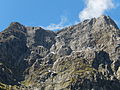
 West aspect | |
| Highest point | |
| Elevation | 1,847 m (6,060 ft) [1] [2] |
| Prominence | 260 m (853 ft) [2] |
| Isolation | 2.23 km (1.39 mi) [2] |
| Coordinates | 44°47′59″S167°47′17″E / 44.79976°S 167.78795°E [1] |
| Geography | |
 Mount Balloon Location in New Zealand | |
 | |
| Interactive map of Mount Balloon | |
| Location | South Island |
| Country | New Zealand |
| Region | Southland |
| Protected area | Fiordland National Park |
| Parent range | Wick Mountains [3] |
| Topo map(s) | NZTopo50 CB08 [3] NZMS260 D41 [4] |
| Geology | |
| Rock type | Metamorphic rock (Orthogneiss) [5] |
| Climbing | |
| First ascent | 1911 |
Mount Balloon is an 1,847-metre-elevation (6,060-foot) mountain in Fiordland, New Zealand.