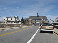
Narragansett, Rhode Island | |
---|---|
Coordinates: 41°26′4″N71°27′45″W / 41.43444°N 71.46250°W | |
Country | United States |
State | Rhode Island |
County | Washington |
Area | |
• Total | 37.8 sq mi (97.8 km2) |
• Land | 14.1 sq mi (36.6 km2) |
• Water | 23.6 sq mi (61.2 km2) |
Elevation | 20 ft (6 m) |
Population (2020) | |
• Total | 14,532 |
• Density | 1,028/sq mi (397.0/km2) |
Time zone | UTC-5 (Eastern (EST)) |
• Summer (DST) | UTC-4 (EDT) |
ZIP Codes | 02874 (Saunderstown), 02882 (Narragansett) |
Area code | 401 |
FIPS code | 44-48340 [1] |
Website | www.narragansettri.gov |
Narragansett is a town in Washington County, Rhode Island, United States. The population was 14,532 at the 2020 census. [2] However, during the summer months the town's population more than doubles to near 34,000. [3] The town of Narragansett occupies a narrow strip of land running along the eastern bank of the Pettaquamscutt River (aka Narrow River) to the shore of Narragansett Bay on the Atlantic Ocean. It was separated from South Kingstown in 1888 and incorporated as a town in 1901. With several ocean beaches and a walkable strip along the ocean front, Narragansett is a resort area in the summer season as well as a popular East Coast surfing spot due to frequent southerly swells from Atlantic Ocean.
For geographic and demographic information on the village of Narragansett Pier, which is part of Narragansett, see the article on Narragansett Pier.
According to the United States Census Bureau, the town has a total area of 37.8 square miles (98 km2), of which, 14.1 square miles (37 km2) of it is land and 23.6 square miles (61 km2) of it (62.56%) is water.
The following villages and neighborhoods are wholly or partially located in Narragansett: Saunderstown (shared with North Kingstown), South Ferry, Bonnet Shores, Narragansett Pier, Point Judith, Galilee, Great Island, Salt Pond, Mettatuxet, and Jerusalem (shared with South Kingstown).
Narragansett is located in the Köppen climate classification Cfa (mild temperate climate). The period from May through mid November is often warm to mild (occasionally hot in June, July, and August) with frequent sunny skies and modest rainfall. The cold season from December through March features cool to cold weather with high temperatures from 40 F (4.4 C) to 49 F (9.4 C). Normally snowfall is light and melts quickly due to the oceanic location. The area averages about 200 frost - free days annually. Narragansett averages 2300 hrs of sunshine annually (slightly higher than the USA average). Narragansett is located in USDA garden zone 7a/7b.
Climate data for Narragansett, Rhode Island | |||||||||||||
---|---|---|---|---|---|---|---|---|---|---|---|---|---|
Month | Jan | Feb | Mar | Apr | May | Jun | Jul | Aug | Sep | Oct | Nov | Dec | Year |
Record high °F (°C) | 66 (19) | 65 (18) | 79 (26) | 89 (32) | 91 (33) | 94 (34) | 98 (37) | 96 (36) | 93 (34) | 83 (28) | 74 (23) | 70 (21) | 98 (37) |
Mean daily maximum °F (°C) | 40 (4) | 42 (6) | 49 (9) | 59 (15) | 69 (21) | 78 (26) | 83 (28) | 82 (28) | 75 (24) | 65 (18) | 54 (12) | 45 (7) | 62 (17) |
Mean daily minimum °F (°C) | 22 (−6) | 23 (−5) | 29 (−2) | 38 (3) | 48 (9) | 58 (14) | 64 (18) | 63 (17) | 56 (13) | 45 (7) | 36 (2) | 27 (−3) | 42 (6) |
Record low °F (°C) | −6 (−21) | −6 (−21) | 3 (−16) | 19 (−7) | 31 (−1) | 41 (5) | 50 (10) | 49 (9) | 35 (2) | 27 (−3) | 15 (−9) | 4 (−16) | −6 (−21) |
Average precipitation inches (mm) | 3.66 (93) | 3.23 (82) | 4.52 (115) | 3.90 (99) | 3.54 (90) | 3.90 (99) | 3.66 (93) | 4.03 (102) | 3.90 (99) | 4.64 (118) | 3.78 (96) | 4.52 (115) | 47.28 (1,201) |
Average snowfall inches (cm) | 7 (18) | 7 (18) | 3 (7.6) | 0 (0) | 0 (0) | 0 (0) | 0 (0) | 0 (0) | 0 (0) | 0.1 (0.25) | 1 (2.5) | 3 (7.6) | 21.1 (53.95) |
Source: [4] |
Census | Pop. | Note | %± |
---|---|---|---|
1890 | 1,408 | — | |
1900 | 1,523 | 8.2% | |
1910 | 1,250 | −17.9% | |
1920 | 993 | −20.6% | |
1930 | 1,258 | 26.7% | |
1940 | 1,560 | 24.0% | |
1950 | 2,288 | 46.7% | |
1960 | 3,444 | 50.5% | |
1970 | 7,138 | 107.3% | |
1980 | 12,088 | 69.3% | |
1990 | 14,985 | 24.0% | |
2000 | 16,361 | 9.2% | |
2010 | 15,868 | −3.0% | |
2020 | 14,532 | −8.4% | |
U.S. Decennial Census [5] [6] |
The 2020 United States census counted 3,308 people, 1,596 households, and 954 families in Narragansett Pier. The population density was 927.4 per square mile (358.1/km2). There were 2,310 housing units at an average density of 647.6 per square mile (250.0/km2). [7] [8] The racial makeup was 92.08% (3,046) white or European American (91.54% non-Hispanic white), 1.03% (34) black or African-American, 0.48% (16) Native American or Alaska Native, 1.84% (61) Asian, 0.06% (2) Pacific Islander or Native Hawaiian, 0.94% (31) from other races, and 3.57% (118) from two or more races. [9] Hispanic or Latino of any race was 2.0% (66) of the population. [10]
Of the 1,596 households, 10.0% had children under the age of 18; 38.0% were married couples living together; 36.7% had a female householder with no spouse or partner present. 41.9% of households consisted of individuals and 20.9% had someone living alone who was 65 years of age or older. [7] The average household size was 2.0 and the average family size was 2.5. [11] The percent of those with a bachelor’s degree or higher was estimated to be 42.3% of the population. [12]
9.9% of the population was under the age of 18, 10.9% from 18 to 24, 15.4% from 25 to 44, 30.6% from 45 to 64, and 33.2% who were 65 years of age or older. The median age was 56.6 years. For every 100 females, the population had 110.6 males. [7] For every 100 females ages 18 and older, there were 113.2 males. [7]
The 2016-2020 5-year American Community Survey estimates show that the median household income was $79,056 (with a margin of error of +/- $16,106) and the median family income was $125,357 (+/- $25,707). Males had a median income of $52,738 (+/- $15,287) versus $20,882 (+/- $20,090) for females. [13] The median income for those above 16 years old was $31,056 (+/- $18,353). [14] Approximately, 8.2% of families and 17.9% of the population were below the poverty line, including 0.0% of those under the age of 18 and 8.0% of those ages 65 or over. [15] [16]
As of the census [1] of 2000, there were 16,361 people, 6,846 households, and 3,847 families residing in the town. The population density was 1,156.5 inhabitants per square mile (446.5/km2). There were 9,159 housing units at an average density of 647.4 per square mile (250.0/km2). The racial makeup of the town was 95.84% White, 0.75% African American, 0.90% Native American, 0.76% Asian, 0.02% Pacific Islander, 0.34% from other races, and 1.40% from two or more races. Hispanic or Latino of any race were 1.25% of the population.
There were 6,846 households, out of which 22.0% had children under the age of 18 living with them, 44.6% were married couples living together, 8.7% had a female householder with no husband present, and 43.8% were non-families. Of all households 27.2% were made up of individuals, and 9.0% had someone living alone who was 65 years of age or older. The average household size was 2.38 and the average family size was 2.86.
In the town, the population was spread out, with 17.3% under the age of 18, 19.6% from 18 to 24, 25.0% from 25 to 44, 24.6% from 45 to 64, and 13.5% who were 65 years of age or older. The median age was 36 years. For every 100 females, there were 94.5 males. For every 100 females age 18 and over, there were 92.4 males.
The median income for a household in the town was $50,363, and the median income for a family was $67,571. Males had a median income of $45,436 versus $31,759 for females. The per capita income for the town was $28,194. About 4.9% of families and 16.0% of the population were below the poverty line, including 8.4% of those under age 18 and 5.0% of those age 65 or over. In 2010, Narragansett was estimated to have 2,743 people in poverty; college students represented 71% of that group, and in comparison, statewide college students make up only 13.7 percent of the total population in poverty. This large college factor, in a relatively small community, has a profound impact on the overall poverty rate. [3]
From September through May the town is home to many students from the University of Rhode Island located in nearby Kingston.
Narragansett is known for its summer recreation and beaches. [17] Fishermen's Memorial State Park, located near Galilee, contains a former military fort (Fort Greene) and a campground.
Three beaches in Narragansett that are most famous are:
Narragansett operates its own Pre-K through 12 educational system with three schools: Narragansett Elementary School, Narragansett Pier Middle School, and Narragansett High School. The Narragansett High School principal, Mr. Daniel F. Warner, was voted the 2008 Principal of the Year. The South County Museum is located within the town. The Narragansett Bay Campus of the University of Rhode Island is located in Narragansett.
Narragansett has prohibited more than three college students from living together per housing unit. [22]
The town is served by two drinking water organizations divided into four systems:
According to Narragansett's 2012 Comprehensive Annual Financial Report, [26] the top employers in the city are:
# | Employer | # of Employees |
---|---|---|
1 | Town of Narragansett | 448 |
2 | University of Rhode Island Narragansett Bay Campus | 245 |
3 | Stop & Shop | 225 |
4 | The Dunes Club | 180 |
5 | VNS Home Health Service | 150 |
6 | Environmental Protection Agency | 160 |
7 | DeWal Industries | 120 |
8 | George's of Galilee | 100 |
9 | National Marine Fisheries Service | 70 |
Thirteen different buildings and districts in Narragansett are listed on the National Register of Historic Places: [27]
Warwick is a city in Kent County, Rhode Island, United States, and is the third-largest city in the state, with a population of 82,823 at the 2020 census. Warwick is located approximately 12 miles (19 km) south of downtown Providence, Rhode Island, 63 miles (101 km) southwest of Boston, Massachusetts, and 171 miles (275 km) northeast of New York City.
Melville is a census-designated place (CDP) in the towns of Middletown and Portsmouth in Newport County, Rhode Island, United States. It lies along the shore of Narragansett Bay. The population of the CDP was 1,320 at the 2010 census. The CDP is named after Admiral George Wallace Melville. Past names for the area include Portsmouth Grove and Bradford.
Cranston, formerly known as Pawtuxet, is a city in Providence County, Rhode Island, United States. The official population of the city in the 2020 United States Census was 82,934, making it the second-largest city in the state. The center of population of Rhode Island is located in Cranston. Cranston is a part of the Providence metropolitan area.
East Providence is a city in Providence County, Rhode Island, United States. The population was 47,139 at the 2020 census, making it the fifth-largest city in the state.
Greenville is a village and census-designated place (CDP) in the town of Smithfield in Providence County, Rhode Island, United States. The population was 8,658 at the 2010 census. The CDP is centered on the village of Greenville but also encompasses the nearby villages of West Greenville and Spragueville, as well as the Mountaindale Reservoir and beach.
Pawtucket is a city in Providence County, Rhode Island. The population was 75,604 at the 2020 census, making the city the fourth-largest in the state. Pawtucket borders Providence and East Providence to the south, Central Falls and Lincoln to the north, and North Providence to the west. The city also borders the Massachusetts municipalities of Seekonk and Attleboro.
Woonsocket, is a city in Providence County, Rhode Island, United States. The population was 43,240 at the 2020 census, making it the sixth largest city in the state. Being Rhode Island's northernmost city, Woonsocket lies directly south of the Massachusetts state line and constitutes part of both the Providence metropolitan area and the larger Greater Boston Combined Statistical Area.
Bradford is a census-designated place (CDP) and historic district in the towns of Westerly and Hopkinton in Washington County, Rhode Island, United States. The population was 1,406 at the 2010 census. The Bradford Village Historic District was listed on the National Register of Historic Places in 1996 as a 224-acre (91 ha) area including 149 contributing buildings, one other contributing site, and one other contributing structure. The CDP as defined by the United States Census Bureau is located only in Westerly.
Charlestown is a town in Washington County, Rhode Island, United States. The population was 7,997 at the 2020 census.
Exeter is a town in Washington County, Rhode Island, United States. Exeter extends east from the Connecticut border to the town of North Kingstown. It is bordered to the north by West Greenwich and East Greenwich, and to the south by Hopkinton, Richmond, and South Kingstown. Exeter's postal code is 02822, although small parts of the town have the mailing address West Kingston (02892) or Saunderstown (02874). The population was 6,460 at the 2020 census.
Narragansett Pier is an unincorporated village and a census-designated place (CDP) in the town of Narragansett in Washington County, Rhode Island, United States. The population was 3,409 at the 2010 census.
North Kingstown is a town in Washington County, Rhode Island, United States, and is part of the Providence metropolitan area. The population was 27,732 in the 2020 census. North Kingstown is home to the birthplace of American portraitist Gilbert Stuart, who was born in the village of Saunderstown. Within the town is Quonset Point, location of the former Naval Air Station Quonset Point, known for the invention of the Quonset hut, as well as the historic village of Wickford.
Richmond is a town in Washington County, Rhode Island. The population was 8,020 at the 2020 census. It contains the villages of Alton, Arcadia, Barberville, Carolina, Hillsdale, Kenyon, Shannock, Tug Hollow, Usquepaug, Wood River Junction, Woodville, and Wyoming. Students in Richmond are part of the Chariho Regional School District.
South Kingstown is a town in, and the county seat of, Washington County, Rhode Island, United States. The population was 31,931 at the 2020 census. South Kingstown is the second largest town in Rhode Island by total geographic area, behind New Shoreham, and the third largest town in Rhode Island by geographic land area, behind Exeter and Coventry.
Wakefield-Peacedale is a census-designated place (CDP) in the town of South Kingstown in Washington County, Rhode Island, United States that includes the villages of Peace Dale and Wakefield. The population was 8,487 at the 2010 census.
Kingston is a village and a census-designated place within the town of South Kingstown in Washington County, Rhode Island, United States, and the site of the main campus of the University of Rhode Island. The population was 6,974 at the 2010 census. Much of the village center is listed on the National Register of Historic Places as Kingston Village Historic District. It was originally known as Little Rest.
Greene is an unincorporated village and census-designated place in the western part of the town of Coventry, Rhode Island, United States. As of the 2010 census it had a population of 888. It is 2 miles (3 km) east of the Connecticut border and the same distance north of West Greenwich. The name derives from Nathanael Greene, a Rhode Island-born general in the American Revolution.
Carolina is a village that straddles the border of the towns of Charlestown and Richmond on the Pawcatuck River in Washington County, Rhode Island. Rhode Island Route 112 passes through the village. Carolina is identified as a census-designated place, with a population of 970 at the 2010 census.
Washington County, known locally as South County, is a county located in the U.S. state of Rhode Island. As of the 2020 census, the population was 129,839. Rhode Island counties have no governmental functions other than as court administrative boundaries, which are part of the state government.
Misquamicut is a census-designated place and fire district in southern Washington County, Rhode Island. It is part of the town of Westerly. The population was listed as 390 in 2010.
{{cite web}}
: CS1 maint: multiple names: authors list (link) CS1 maint: numeric names: authors list (link)