
Wilson County is a county located in the U.S. state of North Carolina. As of the 2020 census, the population was 78,784. The county seat is Wilson. The county comprises the Wilson Micropolitan Statistical Area, which is also included within the Rocky Mount–Wilson–Roanoke Rapids Combined Statistical Area.
Halifax County is a county located in the U.S. state of North Carolina. As of the 2020 census, the population was 48,622. Its county seat is Halifax.

Edgecombe County is a county located in the U.S. state of North Carolina. As of the 2020 census, the population was 48,900. Its county seat is Tarboro.

Rocky Mount is a city in Edgecombe and Nash counties in the U.S. state of North Carolina. The city's population was 54,341 as of the 2020 census, making it the 20th-most populous city in North Carolina at the time. The city is 45 mi (72 km) east of Raleigh, the state capital.

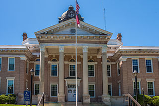
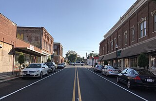
Tarboro is a town located in Edgecombe County, North Carolina, United States. It is part of the Rocky Mount Metropolitan Statistical Area. As of the 2020 census, the town had a population of 10,721. It is the county seat of Edgecombe County. The town is on the opposite bank of the Tar River from Princeville. It is also part of the Rocky Mount-Wilson-Roanoke Rapids CSA. Tarboro is located near the western edge of North Carolina's coastal plain. It has many historical churches, some dating from as early as 1742.
Halifax is a town in Halifax County, North Carolina, United States. The population was 234 at the 2010 census. It is the county seat of Halifax County. It is known as "The Birthplace of Freedom" for being the location for the April 12, 1776, adoption of the Halifax Resolves, which was the first official action by a colony calling for independence. Halifax is also home to the Halifax Historic District, a historic site operated by the North Carolina Department of Cultural Resources. Halifax is part of the Roanoke Rapids, North Carolina Micropolitan Statistical Area.

Roanoke Rapids is a city in Halifax County, North Carolina, United States. The population was 15,754 at the 2010 census. It is the principal city of the Roanoke Rapids Micropolitan Statistical Area, and is also an anchor city of the Rocky Mount-Wilson-Roanoke Rapids CSA, with a total population of 297,726 as of 2018.
Weldon is a town in Halifax County, North Carolina, United States. The population was 1,655 at the 2010 census. It is part of the Roanoke Rapids, North Carolina Micropolitan Statistical Area.

Wilson is a city in and the county seat of Wilson County, North Carolina, United States. It is the 23rd most populous city in North Carolina. Located approximately 40 mi (64 km) east of the capital city of Raleigh, it is served by the interchange of Interstate 95 and U.S. Route 264. Wilson had an estimated population of 49,459 in 2019, according to the U.S. Census Bureau, and is also an anchor city of the Rocky Mount-Wilson-Roanoke Rapids CSA, with a total population of 297,726 as of 2018.
The Wilmington and Weldon Railroad (W&W) name began use in 1855, having been originally chartered as the Wilmington and Raleigh Railroad in 1834. When it opened in 1840, the line was the longest railroad in the world with 161.5 miles (259.9 km) of track. It was constructed in 4 ft 8 in gauge. At its terminus in Weldon, North Carolina, it connected with the Seaboard and Roanoke Railroad and the Petersburg Railroad. The railroad also gave rise to the city of Goldsboro, North Carolina, the midpoint of the W&W RR and the railroad intersection with the North Carolina Railroad.

The Inner Banks is a neologism made up by developers and tourism promoters to describe the inland coastal region of eastern North Carolina. Without historical precedent, the term "Inner Banks" is an early 21st-century construct that is part of an attempt to rebrand the mostly agrarian coastal plain east of I-95 as a more attractive region for visitors and retirees.
The Coastal Plain League was a Minor league baseball affiliated circuit which, except for the war years (1942–1945), operated in North Carolina between 1937 and 1952. It was classified as a "D" league. It grew out of a semi-pro league that operated from 1935 to 1936 under the same Coastal Plain League name. Today, the summer collegiate baseball league has adopted the Coastal Plain League moniker.

Eastern North Carolina is the region encompassing the eastern tier of North Carolina, United States. It is known geographically as the state's Coastal Plain region. Primary subregions of Eastern North Carolina include the Sandhills, the Lower Cape Fear, the Crystal Coast, the Inner Banks and the Outer Banks. It is composed of the 41 most eastern counties in the state. Cities include Greenville, Jacksonville, Wilmington, Rocky Mount and North Carolina's first capital New Bern.

The Rocky Mount Metropolitan Statistical Area, as defined by the United States Census Bureau, is an area consisting of two counties – Edgecombe and Nash – in eastern North Carolina, anchored by the city of Rocky Mount. As of the 2010 census, the MSA had a population of 152,392. It is commonly referred to as the Twin Counties.

Pleasant Hill is an unincorporated community in northwestern Northampton County, North Carolina, United States. The community is on U.S. Route 301, north of Weldon, and lies at an elevation of 125 feet (38 m).

The Roanoke Rapids Micropolitan Statistical Area (μSA) as defined by the United States Census Bureau, is an area consisting of two counties in North Carolina, anchored by the city of Roanoke Rapids.
Edgecombe County Public Schools is a PK–12 graded school district serving Edgecombe County, North Carolina. It was formed in 1993 from the merger of the old Edgecombe County Schools and Tarboro City Schools systems. The system's nine schools serve 7,477 students as of the 2010–11 school year.

Vollis Simpson was an American "outsider" folk artist known for large kinetic sculptures called "whirligigs", which Simpson made from salvaged metal. He lived and worked in Lucama, North Carolina. Many of his larger pieces are on display at the Vollis Simpson Whirligig Park in Wilson, North Carolina, about 10 miles from Lucama.
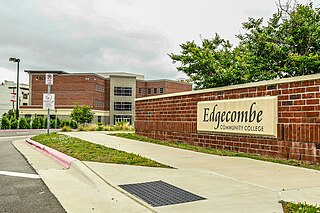
Edgecombe Community College is a public community college in Tarboro, North Carolina. It is part of the North Carolina Community College System.


