Rossmoor, New Jersey

Last updated

Rossmoor, New Jersey
Middlesex County New Jersey Incorporated and Unincorporated areas Rossmoor Highlighted.svg
Map of Rossmoor highlighted within Middlesex County. Right: Location of Middlesex County in New Jersey.
Location map of Middlesex County, New Jersey.svg
Red pog.svg
Rossmoor
Location in Middlesex County
USA New Jersey relief location map.svg
Red pog.svg
Rossmoor
Location in New Jersey
Usa edcp relief location map.png
Red pog.svg
Rossmoor
Location in the United States
Coordinates: 40°19′58″N74°28′21″W / 40.332747°N 74.472422°W / 40.332747; -74.472422
Country Flag of the United States.svg  United States
State Flag of New Jersey.svg  New Jersey
County Middlesex
Township Monroe
Area
[1]
  Total0.69 sq mi (1.77 km2)
  Land0.68 sq mi (1.75 km2)
  Water0.01 sq mi (0.02 km2)  1.48%
Elevation
[2]
131 ft (40 m)
Population
 (2020) [3]
  Total2,992
  Density4,432.59/sq mi (1,712.63/km2)
Time zone UTC−05:00 (Eastern (EST))
  Summer (DST) UTC−04:00 (Eastern (EDT))
ZIP Code
Area code 609
FIPS code 34-64865 [4] [5] [6]
GNIS feature ID02389783 [4] [7]

Rossmoor is an unincorporated community and census-designated place (CDP) in Monroe Township, Middlesex County, New Jersey, United States. [8] [9] [10] As of the 2020 census, the CDP's population was 2,992, [3] up from 2,666 in 2010. [11]

Contents

Rossmoor is a gated age-restricted co-op, active adult community. Rossmoor covers 418 acres (1.69 km2) just off Exit 8A of the New Jersey Turnpike (Interstate 95). It has 2,303 residences, encircling a 104-acre (0.42 km2) championship golf course. The community offers a wide selection of living space, from smaller units of 500 sq ft (46 m2), to larger units with 2,300 sq ft (210 m2) of living space, with its architecture primarily being American Colonial in style. Many residents continue to work in the area or commute to New York City. Express buses stop at Rossmoor for the 55-minute ride to the Port Authority Bus Terminal on 42nd Street in Midtown Manhattan.[ citation needed ]

History

The concept of a "Senior Community" was an unknown entity in the building trade of the early 1960s. But a man from California had already begun to change that by building three successful “Senior Communities” in Southern California. And then – in 1963 - this 47 year old builder was about to repeat his California success in New Jersey on the east coast. That person was Ross Cortese who started our community and after whom it is named. Through his contacts and research in 1962–63, Ross Cortese identified an area in central New Jersey that seemed to have all the right factors. He purchase available farm land directly adjacent to the New Jersey Turnpike (whose initial 118 miles had just been built between 1950 and 1952.) The land was near a large Country Club (the Forsgate Club), in business since 1931, which had already been successful in attracting a good clientele and which might also be available for purchase. He made sure to offer amenities that would attract buyers, and then he marketed the concept to the surrounding public.

In 1963, Arthur Phillips, Esq., then a young lawyer with offices in the Heritage Building near what is now Rossmoor's North Gate, was hired by Cortese to act as attorney for the purchase of the necessary acreage. The purchase was a huge tract of land, covering the area that now includes today's Adult Communities of Clearbrook, Concordia, Encore, the Ponds, Whittingham and all the Forsgate land including the Forsgate Country Club. Each Village was to have its own clubhouse and golf course. Total cost was expected to be $500 million. On May 8, 1964, the plans for the property were made public. The work on Village #1 began in earnest soon afterwards, and the Farmland appearance of Monroe changed abruptly. The last 6 months of 1966 was when construction began in earnest.

Over a 25-year period Rossmoor Village One was built out. As each section was completed a new sub association was established. Today there are 18 sub-associations called Mutuals in Village One (now known as Rossmoor). Rossmoor is overseen by a master association Board of Governors made up of each Mutual's presidents. Together they assure the care and operation of the communities infrastructure and amenities and provide needed administrative and maintenance services to each Mutual and thus every owner.

Although only one of the original five villages were ever developed by Mr. Cortese's company the spirit of his plan did eventually come to fruition through the construction of multiple active adult communities on the original land. His idea expanded even further into Monroe Township providing more and more affordable adult active housing options.

Geography

Rossmoor is in southern Middlesex County, along the western edge of Monroe Township. It is bordered to the north by Forsgate and to the west by Cranbury Township. The New Jersey Turnpike passes just west of the community's border, with Exit 8A at the community's northwestern corner. New Brunswick, the Middlesex county seat, is 10 miles (16 km) to the north, and Newark is 33 miles (53 km) to the north, while Trenton is 21 miles (34 km) to the southwest.

According to the U.S. Census Bureau, the Rossmoor CDP has a total area of 0.68 square miles (1.76 km2), of which 0.01 square miles (0.03 km2), or 1.46%, are water. [1] The community is on flat terrain which drains west toward Shallow Brook, a west-flowing tributary of Devils Brook and part of the Millstone River watershed.

Demographics

Historical population
CensusPop.Note
1990 3,231
2000 3,129−3.2%
2010 2,666−14.8%
2020 2,99212.2%
Population sources: 2000 [12] 2010 [11] [3]

2010 census

The 2010 United States census counted 2,666 people, 1,966 households, and 617 families in the CDP. The population density was 2,947.6 people per square mile (1,138.1 people/km2). There were 2,257 housing units at an average density of 2,495.4 units per square mile (963.5 units/km2). The racial makeup was 93.96% (2,505) White, 4.31% (115) Black or African American, 0.08% (2) Native American, 1.01% (27) Asian, 0.00% (0) Pacific Islander, 0.15% (4) from other races, and 0.49% (13) from two or more races. Hispanic or Latino of any race were 2.63% (70) of the population. [11]

Of the 1,966 households, 0.0% had children under the age of 18; 27.3% were married couples living together; 3.5% had a female householder with no husband present and 68.6% were non-families. Of all households, 65.5% were made up of individuals and 57.6% had someone living alone who was 65 years of age or older. The average household size was 1.36 and the average family size was 2.03. [11]

0.0% of the population were under the age of 18, 0.1% from 18 to 24, 0.8% from 25 to 44, 16.4% from 45 to 64, and 82.7% who were 65 years of age or older. The median age was 77.9 years. For every 100 females, the population had 50.6 males. For every 100 females ages 18 and older there were 50.6 males. [11]

2000 census

As of the 2000 United States Census [5] there were 3,129 people, 2,131 households, and 790 families living in the CDP. The population density was 1,342.3 people/km2 (3,477 people/sq mi). There were 2,345 housing units at an average density of 1,006.0 units/km2 (2,606 units/sq mi). The racial makeup of the CDP was 97.95% White, 0.96% African American, 0.10% Native American, 0.51% Asian, 0.06% from other races, and 0.42% from two or more races. Hispanic or Latino of any race were 0.51% of the population. [12]

There were 2,131 households, out of which none had children under the age of 18 living with them, 33.8% were married couples living together, 2.6% had a female householder with no husband present, and 62.9% were non-families. 61.1% of all households were made up of individuals, and 56.4% had someone living alone who was 65 years of age or older. The average household size was 1.40 and the average family size was 2.03. [12]

In the CDP the population was spread out, with 0.1% under the age of 18, 0.1% from 18 to 24, 0.6% from 25 to 44, 9.8% from 45 to 64, and 89.5% who were 65 years of age or older. The median age was 77 years. For every 100 females, there were 50.1 males. For every 100 females age 18 and over, there were 50.1 males. [12]

The median income for a household in the CDP was $33,104, and the median income for a family was $41,847. Males had a median income of $65,385 versus $38,750 for females. The per capita income for the CDP was $31,178. About 1.1% of families and 4.3% of the population were below the poverty line, including none of those under age 18 and 3.1% of those age 65 or over. [12]

Related Research Articles

<span class="mw-page-title-main">Country Lake Estates, New Jersey</span> Populated place in Burlington County, New Jersey, US

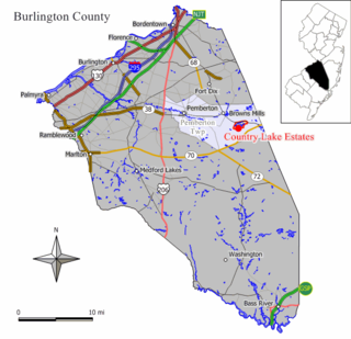
Country Lake Estates is an unincorporated community and census-designated place (CDP) located within Pemberton Township, in Burlington County, in the U.S. state of New Jersey. As of the 2010 United States Census, the CDP's population was 3,943.

<span class="mw-page-title-main">Ramblewood, New Jersey</span> Populated place in Burlington County, New Jersey, US

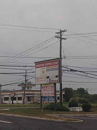
Ramblewood is an unincorporated community and census-designated place (CDP) located within Mount Laurel in Burlington County, in the U.S. state of New Jersey. As of the 2010 United States Census, the CDP's population was 5,907.

<span class="mw-page-title-main">Springdale, New Jersey</span> Populated place in Camden County, New Jersey, US

Springdale is an unincorporated community and census-designated place (CDP) located within Cherry Hill Township, in Camden County, in the U.S. state of New Jersey. As of the 2010 United States Census, the section population was 14,518.

<span class="mw-page-title-main">Brownville, New Jersey</span> Populated place in Middlesex County, New Jersey, US

Brownville is an unincorporated community and census-designated place (CDP) in Old Bridge Township, Middlesex County, New Jersey, United States. As of the 2020 census, the population was 2,746, up from 2,383 in 2010.

<span class="mw-page-title-main">Colonia, New Jersey</span> Place in Middlesex County, New Jersey, United States

Colonia is an unincorporated community and census-designated place (CDP) in Woodbridge Township, Middlesex County, New Jersey, United States. As of the 2020 United States census, the CDP's population was 18,609.

<span class="mw-page-title-main">Concordia, New Jersey</span> Populated place in Middlesex County, New Jersey, US

Concordia is an unincorporated community and census-designated place (CDP) in Monroe Township, Middlesex County, New Jersey, United States. The CDP is oriented around the age restricted gated community of Concordia. As of the 2020 United States census, the CDP's population was 2,455, down from 3,092 in 2010. Prior to 2020, the corner of Concordia known as The Ponds was split off into its own CDP.

<span class="mw-page-title-main">Kendall Park, New Jersey</span> Populated place in Middlesex County, New Jersey, US

Kendall Park is an unincorporated community and census-designated place (CDP) in South Brunswick Township, Middlesex County, New Jersey, United States. As of the 2020 census, the CDP's population was 9,989, up from 9,339 in 2010. Kendall Park has a post office with its own ZIP Code (08824) that encompasses the majority of the CDP, as well as some surrounding areas.

<span class="mw-page-title-main">Madison Park, New Jersey</span> Populated place in Middlesex County, New Jersey, US

Madison Park is an unincorporated community and census-designated place (CDP) in Old Bridge Township, Middlesex County, New Jersey, United States. As of the 2020 census, the CDP's population was 8,050, up from 7,144 in 2010. The name "Madison Park" comes from Madison Township, the original name for Old Bridge Township from 1869 until 1975.

<span class="mw-page-title-main">Princeton Meadows, New Jersey</span> Populated place in Middlesex County, New Jersey, US

Princeton Meadows is an unincorporated community and census-designated place (CDP) in Plainsboro Township, Middlesex County, New Jersey, United States. As of the 2020 census, the population was 14,776.

<span class="mw-page-title-main">Whittingham, New Jersey</span> Populated place in Middlesex County, New Jersey, US

Whittingham, also known as Greenbriar at Whittingham, is an unincorporated community and census-designated place (CDP) located within Monroe Township, in Middlesex County, in the U.S. state of New Jersey. As of the 2010 United States Census, the CDP's population was 2,476. The area is focused around the age-restricted gated community of Whittingham.

<span class="mw-page-title-main">East Freehold, New Jersey</span> Populated place in Monmouth County, New Jersey, US

East Freehold is an unincorporated community and census-designated place (CDP) located within Freehold Township, in Monmouth County, in the U.S. state of New Jersey. As of the 2010 United States Census, the CDP's population was 4,894.

<span class="mw-page-title-main">Cedar Glen Lakes, New Jersey</span> Populated place in Ocean County, New Jersey, US

Cedar Glen Lakes is an unincorporated community and census-designated place (CDP) located within Manchester Township, in Ocean County, in the U.S. state of New Jersey. As of the 2010 United States Census, the CDP's population was 1,421.

<span class="mw-page-title-main">Leisure Village, New Jersey</span> Populated place in Ocean County, New Jersey, US

Leisure Village is an unincorporated community and census-designated place (CDP) located within Lakewood Township, in Ocean County, in the U.S. state of New Jersey. As of the 2010 United States Census, the CDP's population was 4,400. The sprawling active adult community is also locally known as "Original" Leisure Village because it was the first of three neighboring active adult communities bearing similar names. Leisure Village East, and Leisure Village West are the other two communities nearby. Original Leisure Village (OLV) is also referred to by the moniker "The Village of Seven Lakes."

<span class="mw-page-title-main">Leisure Village East, New Jersey</span> Populated place in Ocean County, New Jersey, US

Leisure Village East is an unincorporated community and census-designated place (CDP) located within Lakewood Township, in Ocean County, in the U.S. state of New Jersey. As of the 2010 United States Census, the CDP's population was 4,217. Leisure Village East is one of several active adult communities bearing similar names. Leisure Village and Leisure Village West are the other two communities nearby.

<span class="mw-page-title-main">Ocean Acres, New Jersey</span> Populated place in Ocean County, New Jersey, US

Ocean Acres is an unincorporated community and census-designated place (CDP) split between Barnegat Township and Stafford Township, in Ocean County, in the U.S. state of New Jersey. As of the 2010 United States Census, the CDP's population was 16,142, of which 925 were in Barnegat Township and 15,217 were in Stafford Township. Ocean Acres is located in the northwestern end of Stafford Township and part of Barnegat Township, and is the newest and biggest part of both communities, with approximately 5,500 lots in an area of 6 square miles (16 km2).

<span class="mw-page-title-main">Leisuretowne, New Jersey</span> Populated place in Burlington County, New Jersey, US

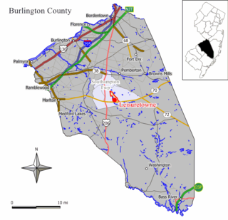
Leisuretowne is an unincorporated community and census-designated place (CDP) located within Southampton Township, in Burlington County, in the U.S. state of New Jersey. As of the 2010 United States Census, the CDP's population was 3,582.

<span class="mw-page-title-main">Rossmoor, California</span> Census-designated place in California, United States

Rossmoor is a planned census-designated place located in Orange County, California. As of the 2020 census, the CDP had a total population of 10,625 up from the 2010 census population of 10,244. The gated Leisure World retirement community in the city of Seal Beach is to the south of Rossmoor, Los Alamitos is to the east and north, and Long Beach is to the west. The community of Rossmoor has two shopping centers within its boundaries, but only one—the Rossmoor Village Square, is now within the political boundaries of Rossmoor. A larger shopping center, the Rossmoor Business Center, was annexed, despite many protests, by the City of Seal Beach in 1967. The Center has been remodeled several times and was renamed the Shops at Rossmoor in the early 2000s.

Brookfield is an unincorporated community and census-designated place (CDP) located within White Township, in Warren County, in the U.S. state of New Jersey. As of the 2010 United States Census, the CDP's population was 675.

<span class="mw-page-title-main">Clearbrook, New Jersey</span> Populated place in Middlesex County, New Jersey, US

Clearbrook is a gated community and census-designated place (CDP) in Monroe Township, Middlesex County, New Jersey, United States. The CDP was named Clearbrook Park in the 2000 and 2010 censuses and renamed in 2020. As of the 2020 United States census, the CDP's population was 2,909, up from 2,667 in 2010.

Forsgate is a golf course community and census-designated place (CDP) in Monroe Township, Middlesex County, New Jersey, United States. It consists of Forsgate Country Club and its associated housing developments. As of the 2020 United States census, it had a population of 2,056.

References

  1. 1 2 "2023 U.S. Gazetteer Files: New Jersey". United States Census Bureau. Retrieved August 8, 2024.
  2. U.S. Geological Survey Geographic Names Information System: Rossmoor Park Census Designated Place, Geographic Names Information System. Accessed November 28, 2012.
  3. 1 2 3 "Census Population API". United States Census Bureau. Retrieved October 11, 2022.
  4. 1 2 Gazetteer of New Jersey Places, United States Census Bureau. Accessed July 21, 2016.
  5. 1 2 U.S. Census website, United States Census Bureau. Accessed September 4, 2014.
  6. Geographic Codes Lookup for New Jersey, Missouri Census Data Center. Accessed June 9, 2023.
  7. US Board on Geographic Names, United States Geological Survey. Accessed September 4, 2014.
  8. New Jersey: 2010 - Population and Housing Unit Counts - 2010 Census of Population and Housing (CPH-2-32), United States Census Bureau, August 2012. Accessed November 28, 2012.
  9. GCT-PH1 - Population, Housing Units, Area, and Density: 2010 - County County Subdivision and Place from the 2010 Census Summary File 1 for Middlesex County, New Jersey Archived 2020-02-12 at archive.today , United States Census Bureau. Accessed November 28, 2012.
  10. Locality Search, State of New Jersey. Accessed April 19, 2015.
  11. 1 2 3 4 5 DP-1 - Profile of General Population and Housing Characteristics: 2010 Demographic Profile Data for Rossmoor CDP, New Jersey, United States Census Bureau. Accessed November 28, 2012.
  12. 1 2 3 4 5 DP-1 - Profile of General Demographic Characteristics: 2000 from the Census 2000 Summary File 1 (SF 1) 100-Percent Data for Rossmoor CDP, New Jersey Archived 2020-02-12 at archive.today , United States Census Bureau. Accessed November 28, 2012.