Statenville, Georgia | |
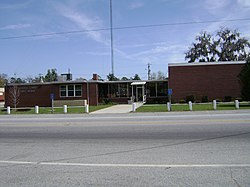
---|---|
Coordinates: 30°42′11″N83°1′40″W / 30.70306°N 83.02778°W | |
Country | United States |
State | Georgia |
County | Echols |
Area | |
• Total | 4.6 sq mi (12.0 km2) |
• Land | 4.6 sq mi (12.0 km2) |
• Water | 0.0 sq mi (0.0 km2) |
Elevation | 138 ft (42 m) |
Population (2010) | |
• Total | 1,040 |
• Density | 225/sq mi (87.0/km2) |
Time zone | UTC-5 (Eastern (EST)) |
• Summer (DST) | UTC-4 (EDT) |
ZIP code | 31648 |
Area code | 229 |
FIPS code | 13-73200 |
GNIS feature ID | 356558 |
Statenville is an unincorporated community and the county seat of Echols County, Georgia, United States. [1] It was formerly a census-designated place (CDP) with a population of 1,040 at the 2010 census. [2] The ZIP code is 31648, and the area code 229.
The town of Statenville was originally called Troublesome. It grew up at a ford on the Alapaha River in the 1850s. Troublesome was renamed Statenville when the latter was designated county seat in 1858 of the newly-formed Echols County. It is named for James Watson Staten, [3] but was erroneously incorporated as "Statesville" in 1859. [4] In 1965, the state officially amended the city's charter to read "Statenville". In 1995, a new state law revoked the city charter, along with dozens of others in Georgia which had inactive governments. This left Echols and Webster as the only counties in Georgia with no incorporated communities whatsoever.
Columbia County has the unincorporated county seat of Appling, though most court functions take place in Evans.
Knoxville is the unincorporated county seat of Crawford County, with the city of Roberta just to its west that grew with the railroad.
In July 2008, a referendum passed to consolidate the city with Echols County by a margin of 639 to 245. [5]
Statenville is located in western Echols County, just east of the Alapaha River. U.S. Route 129 passes through the community, leading north 27 miles (43 km) to Lakeland, south 6 miles (10 km) to the Florida border, and south 14 miles (23 km) to Jasper, Florida. Georgia State Route 94 crosses US 129 in the center of Statenville, leading east 28 miles (45 km) to Fargo and northwest 18 miles (29 km) to Valdosta.
According to the U.S. Census Bureau, the Statenville CDP has a total area of 11.96 square kilometres (4.62 sq mi), all land. [2]
The Echols County School District consists of two schools. [6] The district has 40 full-time teachers and over 700 students. [7]
The South Georgia Regional Library operates the Hansford Allen Echols County Library. Named after timber and turpentine farmer Handsford Allen, who contributed money towards the establishment of the library, it is the smallest library in the system. It opened on July 19, 1992, with its construction funded by State of Georgia money. The community previously had its library in other locations: first in a Methodist church and later in the school district superintendent's courthouse office. [8]
Census | Pop. | Note | %± |
---|---|---|---|
2010 | 1,040 | — | |
U.S. Decennial Census [9] 1850-1870 [10] 1870-1880 [11] 1890-1910 [12] 1920-1930 [13] 1940 [14] 1950 [15] 1960 [16] 1970 [17] 1980 [18] 1990 [19] 2000 [20] 2010 [21] |
Statenville appeared as a census designated place in the 2010 U.S. Census. [21] It no longer was listed thereafter due to consolidation with the county in 2008. [22]
Race / Ethnicity (NH = Non-Hispanic) | Pop 2010 [23] | % 2010 |
---|---|---|
White alone (NH) | 560 | 53.85% |
Black or African American alone (NH) | 121 | 11.63% |
Native American or Alaska Native alone (NH) | 22 | 2.12% |
Asian alone (NH) | 9 | 0.87% |
Pacific Islander alone (NH) | 1 | 0.10% |
Some Other Race alone (NH) | 0 | 0.00% |
Mixed Race/Multi-Racial (NH) | 23 | 2.21% |
Hispanic or Latino (any race) | 304 | 29.23% |
Total | 1,040 | 100.00% |
Echols County is a county located in the southeastern part of the U.S. state of Georgia. As of the 2020 census, the population was 3,697. The county seat is Statenville. Since 2008, Statenville is a disincorporated municipality. Echols and Webster counties are the only two counties in Georgia to currently have no incorporated municipalities. The county was established in 1858 and named in honor of Robert Milner Echols (1798–1847).
Jasper is a city and the county seat of Hamilton County, Florida, United States. The population was 4,546 at the 2020 census.
Montgomery is an unincorporated community and census-designated place (CDP) in Chatham County, Georgia, United States. The population was 4,443 at the 2020 United States census, down slightly from 4,523 in 2010. It is a suburb of Savannah and is part of the Savannah metropolitan area.
Country Club Estates is an unincorporated community and census-designated place (CDP) in Glynn County, Georgia, United States. It is part of the Brunswick metropolitan statistical area. The population was 8,373 at the 2020 census, down from 8,545 in 2010.
Mountain Park is an unincorporated community and census-designated place (CDP) in Gwinnett County, Georgia, United States. The population was 11,554 at the 2010 census. The older name for the area is Trickum, which is reflected in Five Forks-Trickum Road which bisects the community. The older community was centered on Five Forks and Rockbridge Roads.
Lakeland is a city and the county seat of Lanier County, Georgia, United States. The city is the county seat of Lanier County. It is part of the Valdosta, Georgia metropolitan statistical area. The population was 2,875 at the 2020 census.
Sunnyside is an unincorporated community and census-designated place (CDP) in Ware County, Georgia, United States. The population was 1,472 in 2020. It is part of the Waycross micropolitan statistical area.
Morse is an unincorporated community and census-designated place (CDP) in Hansford County, Texas, United States. The population was 157 at the 2020 census.
Cataula is an unincorporated community and census-designated place (CDP) in Harris County, Georgia, United States.
Knoxville is an unincorporated community and census-designated place in Crawford County, Georgia, United States. It is the county seat of Crawford County. The community is part of the Macon Metropolitan Statistical Area. As of the 2020 census, Knoxville had a population of 65.
Boykin is an unincorporated community and census-designated place (CDP) in Miller County, Georgia, United States. The 2020 census listed a population of 151.
Lamont is an unincorporated community and census-designated place (CDP) in Jefferson County, Florida, United States. As of the 2020 census,the population was 170, down from 178 at the 2010 census. It is part of the Tallahassee, Florida Metropolitan Statistical Area.
Perkins is a census-designated place and unincorporated community in Jenkins County, Georgia, United States. As of the 2010 census it had a population of 91.
Calvary is a census-designated place and unincorporated community in Grady County, Georgia, United States. As of 2020, its population was 129. It is located along Georgia State Route 111, 15 miles (24 km) southwest of Cairo, the Grady County seat. Tallahassee, Florida, is 23 miles (37 km) to the south.
Seville is an unincorporated community and census-designated place (CDP) in Wilcox County, Georgia, United States. Per the 2020 census, the population was 197. It lies approximately 0.5 miles (0.80 km) away from the Crisp County line, and about 4 miles (6.4 km) away from Pitts.
Empire is an unincorporated community and census-designated place in Dodge and Bleckley counties in the U.S. state of Georgia. As of the 2020 census, the CDP had a population of 319.
Mineral Bluff is a census-designated place and unincorporated community located in Fannin County in the U.S. state of Georgia. Its population was 223 as of the 2020 census. The community is situated 6 miles (10 km) northeast of the city of Blue Ridge, the county seat, 80 miles (130 km) east of Chattanooga, Tennessee, and 100 miles (160 km) north of Atlanta.
Godfrey is an unincorporated community and census-designated place in Morgan County, in the U.S. state of Georgia. It first appeared as a CDP in the 2020 Census with a population of 108.
Cogdell is an unincorporated community and census-designated place (CDP) in the northeast corner of Clinch County, Georgia, United States. It is on Georgia State Route 122, 22 miles (35 km) west of Waycross and 24 miles (39 km) east of Lakeland. Homerville, the Clinch county seat, is 10 miles (16 km) to the south.