Sullivan's Island, South Carolina

Last updated

Sullivan's Island, South Carolina
Sullivan's Island viewed from Fort Moultrie.JPG
Sullivan's Island viewed from Fort Moultrie
Coordinates: 32°45′48″N79°50′16″W / 32.76333°N 79.83778°W / 32.76333; -79.83778
CountryUnited States
State South Carolina
County Charleston
Settled17th century (as O'Sullivan's Island)
Named for Captain Florence O'Sullivan
Government
   Mayor Patrick O'Neil
Area
[1]
  Total3.44 sq mi (8.91 km2)
  Land2.50 sq mi (6.47 km2)
  Water0.94 sq mi (2.44 km2)
Elevation
9 ft (3 m)
Population
 (2020) [2]
  Total1,891
  Density757.01/sq mi (292.28/km2)
Time zone UTC−5 (EST)
  Summer (DST) UTC−4 (EDT)
ZIP code
29482
Area code(s) 843, 854
FIPS code 45-70090 [3]
GNIS feature ID1231842 [4]
Website sullivansisland-sc.com

Sullivan's Island, historically known as O'Sullivan's Island [5] , is a town and island in Charleston County, South Carolina, United States, at the entrance to Charleston Harbor, with a population of 1,791 at the 2010 census, [6] and 1,891 people in 2020. [7] The town is part of the Charleston metropolitan area, and is considered a very affluent suburb of Charleston.

Contents

Sullivan's Island was the point of entry for approximately 40 to 50 percent of the 400,000 enslaved Africans brought to Colonial America, meaning that 99% of all African Americans have ancestors that came through the island. [8] [9] [10] It has been likened to Ellis Island, the 19th-century reception point for immigrants in New York City. [11] During the American Revolution, the island was the site of a major battle at Fort Sullivan on June 28, 1776, since renamed Fort Moultrie in honor of the American commander at the battle.

On September 23, 1989, Hurricane Hugo came ashore near Sullivan's Island; few people were prepared for the destruction that followed in its wake. The eye of the hurricane passed directly over Sullivan's Island. The Ben Sawyer Bridge was a casualty, breaking free of its locks. Before the storm was over, one end of the bridge was in the water and the other was pointing skyward. Sullivan's Island police chief, Jack Lilien, was the last person to leave the island before the bridge gave way.

History

Circa 1900 building on Sullivan's Island, renovated for use as condominiums Condos on Sullivans Island.jpg
Circa 1900 building on Sullivan's Island, renovated for use as condominiums

The island was known as O'Sullivan's Island, [5] named for Captain Florence O'Sullivan, who was stationed here as a lookout in the late 17th century. O'Sullivan was captain of one of the ships in the first fleet to establish the colonial settlement of Charles Town. In 1671, he became surveyor general. He appears in the earliest record of Irish immigration to the Carolinas, mentioned as being taken on "at Kingsayle (Kinsale) in Ireland".

Sullivan's Island was used as a quarantine station for enslaved Africans, who were housed in various "pest houses" on the island and checked for communicable diseases before they were transported to Charleston for sale at public auction. [12] Sullivan's Island was the port of entry for over 40% of the estimated 400,000 enslaved Africans transported to Colonial America, making it the largest slave port in North America. It is estimated that more than half, if not all, of all African Americans have ancestors who passed through Sullivan's Island. [12]

"There is no suitable memorial, or plaque, or wreath or wall, or park or skyscraper lobby," writer Toni Morrison said in 1989. [13] "There's no 300-foot tower, there's no small bench by the road."

On July 26, 2008, the Toni Morrison Society dedicated a small, black, steel bench on Sullivan's Island to the memory of the Africans forced into slavery, one of several which are planned. [12] The memorial was privately funded. [14]

In 2009, the National Park Service installed a commemorative marker at Fort Moultrie describing the Sullivan's Island Quarantine Station. The text on the plaque reads:

This is Sullivan's Island

A place where...Africans were brought to this country under extreme conditions of human bondage and degradation. Tens of thousands of captives arrived on Sullivan's Island from the West African shores between 1700 and 1775. Those who remained in the Charleston community and those who passed through this site account for a significant number of the African-Americans now residing in these United States. Only through God's blessings, a burning desire for justice, and persistent will to succeed against monumental odds, have African-Americans created a place for themselves in the American mosaic.

A place where...We commemorate this site as the entry of Africans who came and who contributed to the greatness of our country. The Africans who entered through this port have moved on to meet the challenges created by injustices, racial and economic discrimination, and withheld opportunities. Africans and African-Americans, through the sweat of their brow, have distinguished themselves in the Arts, Education, Medicine, Politics, Religion, Law, Athletics, Research, Artisans and Trades, Business, Industry, Economics, Science, Technology and Community and Social Services.

A place where...This memorial rekindles the memory of a dismal time in American history, but it also serves as a reminder for a people who – past and present, have retained the unique values, strength and potential that flow from our West African culture which came to this nation through the middle passage.

Erected in 1990 by the S.C. Department of Archives and History. The Charleston Club of S.C. and the Avery Research Center.

Pursuant to a request from the South Carolina General Assembly as Evidenced in concurrent resolution S. 719, Adopted June 3, 1990. [15]

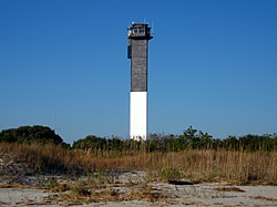
Albert Wheeler Todd, an architect from Charleston, designed a town hall for the island. [16] For most of its history, the town, located on the southwest half of the island, was known as "Moultrieville". Later, Atlanticville, a community on the north-east of the islands, merged with Moultrieville and together the two became the town of Sullivan's Island. In 1962, the new Charleston Light was built.

In May 2006, the Town of Sullivan's Island became the first municipality in South Carolina to ban smoking in all public places. The ordinance passed 4–2 and the ban went into effect in June. [17]

The Atlanticville Historic District, Battery Gadsden, Battery Thomson, Fort Moultrie Quartermaster and Support Facilities Historic District, Moultrieville Historic District, Dr. John B. Patrick House, Sullivan's Island Historic District, and U.S. Coast Guard Historic District are listed on the National Register of Historic Places. [18]

Fort Moultrie

The Moultrie Flag (also known as the Liberty Flag) being raised over Fort Moultrie, after the Patriot victory in the Battle of Sullivan's Island. Battle of Sullivans Island.jpg
The Moultrie Flag (also known as the Liberty Flag) being raised over Fort Moultrie, after the Patriot victory in the Battle of Sullivan's Island.

On June 28, 1776, an incomplete fort was held by South Carolinian forces under Colonel William Moultrie against an invasion by a British force under the command of Henry Clinton sailing with Commodore Sir Peter Parker's Royal Navy fleet. The British cannonade proved to have no effect on the sand-filled palmetto log walls of the fort; the only fatalities were the result of those shots that carried over the walls.

During this battle, a flag designed by Moultrie flew over the fortress; it was dark blue with a crescent moon on it bearing the word "liberty". When this flag was shot down, Sergeant William Jasper reportedly picked it up and held it aloft, rallying the troops until a new standard could be provided. Because of the importance of this pivotal battle, that flag became symbolic of liberty in South Carolina, the South, and the nation as a whole.

The Battle of Sullivan's Island was commemorated by the addition of a white palmetto tree to the flag used to rally that day, known as the Moultrie Flag. This was used as the basis of the state flag of South Carolina. The victory is celebrated and June 28 is known as Carolina Day.

The history of the island has been dominated by Fort Moultrie, which, until its closure in the late 1940s, served as the base of command for the defense of Charleston. After World War II, the Department of Defense concluded that such coastal defense installations were no longer needed, given current technology and style of war. It is now used as heritage tourism.

Breach Inlet between Sullivan's Island and Isle of Palms Breach Inlet Sullivan's Island.jpg
Breach Inlet between Sullivan's Island and Isle of Palms

Geography

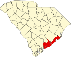
Sullivan's Island is located along the Atlantic Ocean near the center of Charleston County. The town is bordered to the west by the entrance to Charleston Harbor, to the north by Cove Inlet and the Intracoastal Waterway, and to the east by Breach Inlet and Swinton Creek. The Ben Sawyer Bridge connects Sullivan's Island to Mount Pleasant to the north. A bridge spanning Breach Inlet connects it to Isle of Palms to the east. By road it is 9 miles (14 km) north and then west into Charleston.

According to the U.S. Census Bureau, the town of Sullivan's Island has a total area of 3.4 square miles (8.9 km2), of which 2.5 square miles (6.5 km2) is land and 0.93 square miles (2.4 km2), or 27.36%, is water. [6]

Climate

According to the Köppen Climate Classification system, Sullivan's Island has a humid subtropical climate, abbreviated "Cfa" on climate maps. The hottest temperature recorded in Sullivan's Island was 105 °F (40.6 °C) on June 26, 1952, while the coldest temperature recorded was 9 °F (−12.8 °C) on January 21, 1985. [19]

Climate data for Sullivan's Island, South Carolina, 1991–2020 normals, extremes 1951–present
MonthJanFebMarAprMayJunJulAugSepOctNovDecYear
Record high °F (°C)78
(26)
83
(28)
90
(32)
93
(34)
99
(37)
105
(41)
101
(38)
103
(39)
99
(37)
94
(34)
89
(32)
84
(29)
105
(41)
Mean maximum °F (°C)72.3
(22.4)
74.3
(23.5)
79.8
(26.6)
85.0
(29.4)
91.1
(32.8)
95.5
(35.3)
97.8
(36.6)
95.9
(35.5)
92.8
(33.8)
87.8
(31.0)
81.0
(27.2)
74.3
(23.5)
98.7
(37.1)
Mean daily maximum °F (°C)59.2
(15.1)
61.4
(16.3)
67.1
(19.5)
74.8
(23.8)
82.2
(27.9)
87.9
(31.1)
91.1
(32.8)
90.0
(32.2)
85.9
(29.9)
78.3
(25.7)
69.2
(20.7)
62.1
(16.7)
75.8
(24.3)
Daily mean °F (°C)47.8
(8.8)
50.2
(10.1)
55.9
(13.3)
64.1
(17.8)
72.7
(22.6)
78.9
(26.1)
82.0
(27.8)
81.0
(27.2)
76.8
(24.9)
67.9
(19.9)
58.1
(14.5)
51.0
(10.6)
65.5
(18.6)
Mean daily minimum °F (°C)36.5
(2.5)
39.0
(3.9)
44.7
(7.1)
53.5
(11.9)
63.2
(17.3)
69.9
(21.1)
73.0
(22.8)
72.0
(22.2)
67.7
(19.8)
57.5
(14.2)
47.0
(8.3)
39.8
(4.3)
55.3
(13.0)
Mean minimum °F (°C)23.2
(−4.9)
27.7
(−2.4)
31.6
(−0.2)
41.5
(5.3)
51.9
(11.1)
61.8
(16.6)
67.6
(19.8)
65.6
(18.7)
58.7
(14.8)
44.2
(6.8)
34.5
(1.4)
27.9
(−2.3)
21.1
(−6.1)
Record low °F (°C)9
(−13)
12
(−11)
18
(−8)
23
(−5)
37
(3)
49
(9)
59
(15)
55
(13)
46
(8)
22
(−6)
22
(−6)
11
(−12)
9
(−13)
Average precipitation inches (mm)3.81
(97)
3.30
(84)
3.49
(89)
3.59
(91)
3.33
(85)
5.36
(136)
5.97
(152)
3.72
(94)
5.47
(139)
3.94
(100)
3.00
(76)
3.62
(92)
51.60
(1,311)
Average precipitation days (≥ 0.01 in)10.48.68.27.06.19.010.510.57.97.88.09.8103.8
Source 1: NOAA (precip days 19812010) [20] [21]
Source 2: National Weather Service [19]

Airport

The town of Sullivan's Island is served by the Charleston International Airport. It is located in the City of North Charleston and is about 12 mi (19 km) northwest of Sullivan's Island. It is the busiest passenger airport in South Carolina ( IATA : CHS, ICAO : KCHS). The airport shares runways with the adjacent Charleston Air Force Base. Charleston Executive Airport is a smaller airport located in the John's Island section of the city of Charleston and is used by noncommercial aircraft. Both airports are owned and operated by the Charleston County Aviation Authority.

Demographics

Historical population
CensusPop.Note
1960 1,358
1970 1,4265.0%
1980 1,86730.9%
1990 1,623−13.1%
2000 1,91117.7%
2010 1,791−6.3%
2020 1,8915.6%
U.S. Decennial Census [22] [2]
The beach at Sullivan's Island Sullivans Island in South Carolina.jpg
The beach at Sullivan's Island

2020 census

Sullivan's Island racial composition [7]
RaceNum.Perc.
White (non-Hispanic)1,77093.6%
Black or African American (non-Hispanic)70.37%
Asian 160.85%
Other/Mixed 512.7%
Hispanic or Latino 472.49%

As of the 2020 United States census, there were 1,891 people, 821 households, and 619 families residing in the town.

2000 census

As of the census [3] of 2000, there were 1,911 people, 797 households, and 483 families residing in the town. The population density was 787.2 inhabitants per square mile (303.9/km2). There were 1,045 housing units at an average density of 430.5 per square mile (166.2/km2). The racial makeup of the town was 98.74% White, 0.63% African American, 0.05% Native American, 0.16% Asian, and 0.42% from race were 0.84% of the population. .

There were 797 households, out of which 29.1% had children under the age of 18 living with them, 50.9% were married couples living together, 7.0% had a female householder with no husband present, and 39.3% were non-families. 29.9% of all households were made up of individuals, and 7.0% had someone living alone who was 65 years of age or older. The average household size was 2.40 and the average family size was 3.01.

In the town, the population was spread out, with 24.0% under the age of 18, 5.0% from 18 to 24, 29.0% from 25 to 44, 31.0% from 45 to 64, and 10.9% who were 65 years of age or older. The median age was 41 years. For every 100 females, there were 100.7 males. For every 100 females age 18 and over, there were 97.7 males.

The median income for a household in the town was $72,955, and the median income for a family was $96,455. Males had a median income of $58,571 versus $41,029 for females. The per capita income for the town was $49,427. About 1.4% of families and 4.2% of the population were below the poverty line, including 2.2% of those under age 18 and 0.9% of those age 65 or over.

Sullivan's Island has some of the highest per capita real estate costs in the United States. Although not the most expensive in the region, home values on Sullivan's Island, based on the small size of the island and number of regular residents, makes it one of the priciest locations.

Ethnicity

As of 2016 the largest self-reported ancestries/ethnicities in Sullivan's Island, South Carolina were: [23]

Largest ancestries (2016)Percent
English 19.5%
German 14.0%
Irish 12.6%
"American" 11.5%
French 10.0%
Scottish 6.0%
Italian 3.4%
Russian 2.8%
Polish 2.0%
Dutch 1.6%

Literary references

Musical references

Sullivan's Island is mentioned in the song Palmetto Rose by Jason Isbell in his 2015 album Something More Than Free .

Other references

Charleston Light Sullivans-Lighthouse.jpg
Charleston Light

E. Lee Spence, a pioneer underwater archaeologist, was a longtime resident of Sullivan's Island. In the 1960s and 1970s, he discovered many shipwrecks along its shores. Those discoveries included the Civil War blockade runners Flora , Beatrice , Stono , Flamingo , Prince Albert , and the Celt (also known as the Colt).

In 1981, adventure novelist and marine archaeologist Clive Cussler and his organization, the National Underwater and Marine Agency, discovered the wreck of the blockade runner Raccoon off Sullivan's Island.

Several districts and properties on Sullivans' Island have been listed in the National Register of Historic Places: Atlanticville Historic District, [26] Moultrieville Historic District, [27] Sullivans Island Historic District, [28] Fort Moultrie Historic District, [29] U. S. Coast Guard Historic District, [30] Battery Gadsden [31] and Battery Thomson. [32]

See also

Related Research Articles

<span class="mw-page-title-main">Charleston, South Carolina</span> City in South Carolina, United States

Charleston is the most populous city in the U.S. state of South Carolina, the county seat of Charleston County, and the principal city in the Charleston metropolitan area. The city lies just south of the geographical midpoint of South Carolina's coastline on Charleston Harbor, an inlet of the Atlantic Ocean formed by the confluence of the Ashley, Cooper, and Wando rivers. Charleston had a population of 150,277 at the 2020 census. The 2020 population of the Charleston metropolitan area, comprising Berkeley, Charleston, and Dorchester counties, was 799,636 residents, the third-largest in the state, 8th-largest in the Deep South and the 74th-largest metropolitan statistical area in the United States.

<span class="mw-page-title-main">Fort Sumter</span> Historic coastal fortress in South Carolina, United States

Fort Sumter is a sea fort built on an artificial island near Charleston, South Carolina to defend the region from a naval invasion. It was built after British forces captured and occupied Washington during the War of 1812 via a naval attack. The fort was still incomplete in 1861 when the Battle of Fort Sumter occurred, sparking the American Civil War. It was severely damaged during the battle and left in ruins. Although there were some efforts at reconstruction after the war, the fort as conceived was never completed. Since the middle of the 20th century, Fort Sumter has been open to the public as part of the Fort Sumter and Fort Moultrie National Historical Park, operated by the National Park Service.

<span class="mw-page-title-main">Charleston County, South Carolina</span> County in South Carolina, United States

Charleston County is located in the U.S. state of South Carolina along the Atlantic coast. As of the 2020 census, the population was 408,235, making it the third most populous county in South Carolina. Its county seat is Charleston. It is also the largest county in the state by total area, although Horry County has a larger land area. The county was created in 1800 by an act of the South Carolina State Legislature.

<span class="mw-page-title-main">Berkeley County, South Carolina</span> County in South Carolina, United States

Berkeley County is a county in the U.S. state of South Carolina. As of the 2020 census, its population was 229,861. Its county seat is Moncks Corner, and the largest community is Goose Creek. After two previous incarnations of Berkeley County, the current county was created in 1882. Berkeley County is included in the Charleston-North Charleston, SC Metropolitan Statistical Area.

<span class="mw-page-title-main">Moultrie County, Illinois</span> County in Illinois, United States

Moultrie County is a county in the U.S. state of Illinois. According to the 2020 United States Census, its population was 14,526. Its county seat is Sullivan. The name is pronounced as in "mole tree", unlike the pronunciation of its namesake, the South Carolinian Revolutionary War hero William Moultrie.

<span class="mw-page-title-main">Mount Pleasant, South Carolina</span> Town in South Carolina, United States

Mount Pleasant is a large suburban town in Charleston County, South Carolina, United States. In the Lowcountry, it is the fourth-most populous municipality in South Carolina, and for several years was one of the state's fastest-growing areas, doubling in population between 1990 and 2000. The population was 90,801 at the 2020 census. It is part of the Charleston metropolitan area.

<span class="mw-page-title-main">Society Hill, South Carolina</span> Town in South Carolina, United States

Society Hill is a town in Darlington County, South Carolina, United States alongside the Pee Dee River. It is the oldest community in Darlington County and one of the first towns founded in South Carolina. The town was once the intellectual center of the Pee Dee region. However, the town's fortunes declined in the 19th century after rivers became less important as means of transportation. It is part of the Florence Metropolitan Statistical Area.

<span class="mw-page-title-main">William Moultrie</span> American politician

William Moultrie was an American planter and politician who became a general in the American Revolutionary War. As colonel leading a state militia, in 1776 he prevented the British from taking Charleston, and Fort Moultrie was named in his honor.

<span class="mw-page-title-main">Battle of Fort Sumter</span> 1861 American Civil War battle

The Battle of Fort Sumter was the bombardment of Fort Sumter near Charleston, South Carolina by the South Carolina militia. It ended with its surrender by the United States Army, beginning the American Civil War.

<span class="mw-page-title-main">Flag of South Carolina</span> Flag of the U.S. state of South Carolina

The flag of South Carolina is a symbol of the U.S. state of South Carolina consisting of a blue field with a white palmetto tree and white crescent. Roots of this design have existed in some form since 1775, being based on one of the first American Revolutionary War flags. While keeping most of its design intact since its adoption, it has varied over the years.

<span class="mw-page-title-main">Fort Moultrie</span> United States historic place

Fort Moultrie is a series of fortifications on Sullivan's Island, South Carolina, built to protect the city of Charleston, South Carolina. The first fort, formerly named Fort Sullivan, built of palmetto logs, inspired the flag and nickname of South Carolina, as "The Palmetto State". The fort was renamed for the U.S. patriot commander in the Battle of Sullivan's Island, General William Moultrie. During British occupation, in 1780–1782, the fort was known as Fort Arbuthnot.

<span class="mw-page-title-main">Fort Sumter and Fort Moultrie National Historical Park</span> National Historical Park of the United States

Fort Sumter and Fort Moultrie National Historical Park is a United States National Historical Park located in Charleston County, in coastal South Carolina. It mainly protects Fort Sumter, Fort Moultrie, the Charleston Light and Liberty Square. It was known as Fort Sumter National Monument until it was renamed in the John D. Dingell Jr. Conservation, Management, and Recreation Act, signed March 12, 2019.

<span class="mw-page-title-main">James Island, South Carolina</span> Town in South Carolina, United States

James Island is a town in Charleston County, South Carolina, United States. It is located in the central and southern parts of James Island. James Island is included within the Charleston-North Charleston-Summerville metropolitan area and the Charleston-North Charleston Urbanized Area.

<span class="mw-page-title-main">West Ashley</span>

West Ashley, or more formally, west of the Ashley, is one of the six distinct areas of the city proper of Charleston, South Carolina. As of July 2022, its estimated population was 83,996. Its name is derived from the fact that the land is west of the Ashley River.

<span class="mw-page-title-main">Battle of Sullivan's Island</span> 1776 American Revolutionary War battle

The Battle of Sullivan's Island or the Battle of Fort Sullivan was fought on June 28, 1776, during the American Revolutionary War. It took place near Charleston, South Carolina, during the first British attempt to capture the city from American forces. It is also sometimes referred to as the first siege of Charleston, owing to a more successful British siege in 1780.

<span class="mw-page-title-main">Sullivan's Island Range Lights</span> Lighthouses in South Carolina, US

The Sullivan's Island Range Lights were range lights on the southern end of Sullivan's Island in Charleston County, South Carolina. The light station was first established in 1848 and was destroyed in 1861 during the Civil War. It was rebuilt after the war and the lights were in existence at least as late as 1901. Neither of the range lights still remains today.

<span class="mw-page-title-main">National Register of Historic Places listings in Columbia, South Carolina</span>

This is a list of the National Register of Historic Places listings in Columbia, South Carolina.

<span class="mw-page-title-main">History of Charleston, South Carolina</span>

The history of Charleston, South Carolina, is one of the longest and most diverse of any community in the United States, spanning hundreds of years of physical settlement beginning in 1670. Charleston was one of leading cities in the South from the colonial era to the Civil War in the 1860s. The city grew wealthy through the export of rice and, later, sea island cotton and it was the base for many wealthy merchants and landowners. Charleston was the capital of American slavery.

<span class="mw-page-title-main">Battery Gadsden</span> United States historic place

Battery Gadsden is a historic artillery battery located at Sullivan's Island, Charleston County, South Carolina. It was built in 1903–1904, and is one of a series of batteries stretching from Fort Moultrie to the eastern end of Sullivan's Island. It was named after Christopher Gadsden. Until decommissioned in 1917, the concrete battery housed four, six inch guns. It measures approximately 377 feet long and 84 feet wide, with the front or ocean side of the battery at approximately 7 feet high. Battery Gadsden and its neighbor Battery Thomson provided fortification at the mouth of Charleston Harbor. The battery now houses the Edgar Allan Poe Branch of the Charleston County Public Library. It was built at the same time as Battery Jasper.

<span class="mw-page-title-main">Moultrieville Historic District</span> Historic district in South Carolina, United States

Moultrieville Historic District is a national historic district located at Sullivan's Island, Charleston County, South Carolina. The district encompasses 18 contributing buildings and 1 contributing site in Moultrieville. They predominantly include frame residences built between about 1830 to 1930 which are known as "Island Houses." Also located in the district are the Stella Maris Catholic Church (1869-1873) and Fort Moultrie Torpedo Shed/Mines Storehouse.

References

  1. "ArcGIS REST Services Directory". United States Census Bureau. Retrieved October 15, 2022.
  2. 1 2 "Census Population API". United States Census Bureau. Retrieved October 15, 2022.
  3. 1 2 "U.S. Census website". United States Census Bureau . Retrieved January 31, 2008.
  4. "US Board on Geographic Names". United States Geological Survey. October 25, 2007. Retrieved January 31, 2008.
  5. 1 2 "Chapter 5: Cultural Resources Element" (PDF). Sullivan's Island Comprehensive Plan 2018-2028. Archived (PDF) from the original on January 8, 2023. Retrieved January 8, 2023.{{cite book}}: |website= ignored (help)
  6. 1 2 "Geographic Identifiers: 2010 Census Summary File 1 (G001): Sullivan's Island town, South Carolina". U.S. Census Bureau, American Factfinder. Archived from the original on February 13, 2020. Retrieved June 30, 2015.
  7. 1 2 "Explore Census Data". data.census.gov. Retrieved December 15, 2021.
  8. IBW21 (February 11, 2020). "The Erasure of the History of Slavery at Sullivan's Island". Institute of the Black World 21st Century. Retrieved July 13, 2021.{{cite web}}: CS1 maint: numeric names: authors list (link)
  9. Twitty, Michael (August 2017). The cooking gene : a journey through African American culinary history in the Old South (First ed.). New York, NY. ISBN   978-0-06-237929-0. OCLC   971130586.{{cite book}}: CS1 maint: location missing publisher (link)
  10. "Nearly 1,000 Cargos: The Legacy of Importing Africans into Charleston". Charleston County Public Library. October 5, 2018. Retrieved July 13, 2021.
  11. Chin, Adeline; Kermeliotis, Teo (May 25, 2018) [December 7, 2012]. "African Slave Traditions Live On in U.S." CNN .
  12. 1 2 3 Morekis, Jim (February 2018). Coastal Carolinas. Avalon Travel (Moon). p. 170. ISBN   978-1-64049-245-5 . Retrieved November 20, 2018.
  13. Morrison, Toni. "a bench by the road". uuworld.org. Retrieved April 15, 2014.
  14. Lee, Felicia R. (July 28, 2008). "Bench of Memory at Slavery's Gateway". The New York Times .
  15. "What You Need to Know about Slavery and Sullivan's Island". Black Then. May 24, 2018.
  16. The Buildings of Charleston: A Guide to the City's Architecture By Jonathan H. Poston, page 316
  17. "Sullivan's Island Passes Area's 1st Smoking Ban [05/18/06]". Archived from the original on July 19, 2012. Retrieved November 10, 2006.
  18. "National Register Information System". National Register of Historic Places . National Park Service. July 9, 2010.
  19. 1 2 "NOAA Online Weather Data – NWS Charleston". National Weather Service. Retrieved March 8, 2023.
  20. "U.S. Climate Normals Quick Access – Station: Sullivans IS, SC (19912020)". National Oceanic and Atmospheric Administration. Retrieved March 8, 2023.
  21. "U.S. Climate Normals Quick Access – Station: Sullivans Island, SC". National Oceanic and Atmospheric Administration. Retrieved March 8, 2023.
  22. "Census of Population and Housing". Census.gov. Retrieved June 4, 2015.
  23. "American FactFinder – Results". factfinder.census.gov. U. S. Census – Bureau. Archived from the original on February 13, 2020. Retrieved December 24, 2017.
  24. Sova, Dawn B. Edgar Allan Poe: A to Z. New York: Checkmark Books, 2001: 98. ISBN   0-8160-4161-X.
  25. "Chasing Poe's ghost in Charleston". Baltimore Sun . October 7, 2014.
  26. "SCDAH". Nationalregister.sc.gov. September 6, 2007. Retrieved April 15, 2014.
  27. "SCDAH". Nationalregister.sc.gov. September 6, 2007. Retrieved April 15, 2014.
  28. "SCDAH". Nationalregister.sc.gov. September 6, 2007. Retrieved April 15, 2014.
  29. "SCDAH". Nationalregister.sc.gov. September 6, 2007. Retrieved April 15, 2014.
  30. "SCDAH". Nationalregister.sc.gov. June 19, 1973. Retrieved April 15, 2014.
  31. "SCDAH". Nationalregister.sc.gov. June 25, 1974. Retrieved April 15, 2014.
  32. "SCDAH". Nationalregister.sc.gov. June 25, 1974. Retrieved April 15, 2014.

Further reading