1Most severe tornado damage; see Enhanced Fujita scale 2Time from first tornado to last tornado
An unseasonably strong tornado outbreak began on January 7, 2008 and continued for nearly four days across the Central and Southern United States, with the hardest hit area being southwestern Missouri, northwestern Arkansas, and the surrounding area. In addition, a strong supercell in northern Illinois and southeastern Wisconsin produced that region's first January tornadoes since 1967.[2]
More tornadoes occurred across the Mississippi Valley on January 8 and after a break in the activity on January 9, another round of severe weather took place in the Southern United States (primarily Alabama and Mississippi) on January 10. Several damaging tornadoes were reported that day, although no one was killed. In total, over the four-day period, 72 tornadoes were confirmed and four people were killed.
Meteorological synopsis
An unseasonably warm air mass was entrenched over much of central and eastern North America with record highs for much of the region. Several record high temperatures were broken across several states and Canadian provinces from January 7 to January 9 as temperatures rose into the 70s (21–25°C) as far north as the Ohio Valley with dewpoints in the high 50s and low 60s (14–17°C) providing additional fuel for storm development.
In addition, many areas near the Great Lakes region reached the mid to upper 60s (17–20°C) which allowed the northern cells to form, while several areas in southern Ontario and Quebec near the Canada-US border reached near 60°F (16°C).[3][4]
Tornado tracks across Southern Missouri on January 7–8 (Courtesy of NWS Springfield, Missouri)
A strong low-pressure area over the central Great Lakes and its associated cold front combined with intense wind shear to provide a favorable environment for supercell development.[5] Despite only moderate instability (which meant only a slight risk of severe weather was issued by the Storm Prediction Center, and only modest probabilities for severe weather at first[6]), supercells developed throughout the day over much of the central US and continued throughout the evening and overnight hours, continuing into the morning of January 8. The hardest-hit area was in the Ozarks, around Springfield, Missouri, where nearly continuous supercells developed throughout the evening, resulting in numerous tornado touchdowns. In addition to the tornadoes, hail larger than baseballs and damaging straight-line downburst winds as strong as 100mph (160km/h) were reported. At least three people were killed in Missouri as a result of the tornadoes. Two of these deaths occurred near Marshfield and there were also six injuries.[7]
Strong tornadoes also touched down further north near Chicago and Milwaukee causing extensive damage along the Wisconsin/Illinois border as well as several injuries. Strong cells and lines also formed in Michigan prompting rare tornado warnings across central parts of Lower Michigan.[8] Scattered thunderstorms were reported in Northern, Central and Southern Ontario on the evening of January 7.[9] Tornado watches extended from eastern Oklahoma to southwestern Ontario on January 7.[10]
SPC Severe Weather Forecast for January 10, 2008 showing the moderate risk area. (Courtesy of NWS Birmingham, Alabama)
Activity shifted across the Mid-Mississippi Valley on January 8 where tornado watches were issued across Arkansas and Tennessee and later extended across the Ohio Valley to near Columbus, Ohio and Dayton, Ohio until the early morning hours on January 9. A strong tornado in Pope County, Arkansas killed person and additional tornadoes were reported just west of Memphis. During the day, most of the activity was formed into a line that extended from the Ohio Valley to Alabama although thunderstorm-related wind damage was reported as far north as upstate New York and western Pennsylvania.
After a lull in activity on January 9, a separate system across the Southern United States led to more severe weather, including tornadoes, on January 10. A moderate risk of severe weather was issued by the Storm Prediction Center.
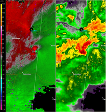
NEXRAD view of a supercell producing an EF3 tornado near Caledonia, Mississippi, displaying relative velocity on the left, and base reflectivity on the right. (Courtesy of NWS Jackson, Mississippi)
Storms developed across Louisiana and Mississippi during the morning and noon periods moving into Alabama with additional storms developing as far north as central and eastern Kentucky where a tornado watch was issued stretching down towards eastern Louisiana and later into Georgia. Multiple strong tornadoes affected Mississippi, Tennessee, and Alabama that evening, including an EF3 that severely damaged the town of Caledonia, Mississippi. More stable air farther east reduced the severe weather potential. Wintry weather including snow, sleet and freezing rain on the northern side of the storm was reported from Wisconsin to Maine on January 10–11. Overall, this outbreak killed four people and injured at least 62 others.
A shed, a house, and other structures had sections of their roofing ripped off. A large barn was destroyed while a second, poorly-constructed one was blown over. A two-story farm house and associated garage were leveled. Several other buildings were severely damaged. A second garage was blown down, 12 rail cars were blown off a railroad, and numerous trees were snapped or uprooted. A semi-trailer was flipped.[13][14]
In Walworth County, three structures sustained minor damage and two structures sustained moderate damage. After crossing into Kenosha County, the tornado impacted Wheatland; 7 homes were affected, 25 sustained minor damage, 27 sustained major damage, and 25 were completely destroyed. In Brighton, 10 homes were affected, 3 sustained minor damage, 3 sustained major damage, and 4 were completely destroyed. Numerous trees were snapped, uprooted, or debarked. Damage to some structures suggested an EF4 rating, but lack of proper anchoring prevented an upgrade.[16][17] This became the earliest confirmed tornado in Wisconsin.[18]
Two homes sustained minor damage and one home sustained major damage in Somers. In Kenosha, 1 home was affected, 21 sustained minor damage, 6 sustained major damage, and 5 were completely destroyed; a church was destroyed as well. Several power lines were toppled, and dozens of trees were snapped or uprooted.[19]
3 deaths – A long-tracked and significant tornado caused extensive damage to homes, trees, and outbuildings. One death occurred in rural Greene County while an additional two occurred in Webster County.[24][25] [26]
In Pulaski County, a few homes and outbuildings were destroyed, injuring three people. In Phelps County, one home and several outbuildings were destroyed. [33][34]
In Phelps County, one home sustained roof damage and numerous trees were damaged. In Maries County, approximately 40 structures were damaged, including a mobile home that was destroyed. Four airplanes were damaged at Rolla National Airport, where an ASOS station measured a gust of 96mph (154km/h).[46][47]
1 death – A strong tornado began in Pope County, affecting 42 structures: 6 sustained minor damage, 29 sustained moderate to heavy damage, and 7 were destroyed. Six chicken houses, two barns, and a number of outbuildings were destroyed. A travel trailer and motor home were overturned, and one death occurred when a mobile home was destroyed. In Conway County, 3 homes were destroyed and 12 others sustained light to heavy damage. A church and 10 other structures were destroyed, and a cemetery, three natural gas well sites, and 13 additional structures were damaged. Hundreds of trees were downed.[69] [70][71]
A house was heavily damaged, with its roof ripped off and tossed 100–200yd (91–183m). Three outbuildings and an equipment shed were destroyed, a trailer was thrown about 75yd (69m), approximately 10 power poles were snapped, windows of vehicles were broken, and a few large trees were snapped. A pump house was thrown into a propane tank, causing a propane leak.[72]
Numerous homes sustained roof damage, many trees were downed, a metal farm equipment building was shifted off its foundation, and a vehicle was destroyed.[75]
A mobile home was shifted off its foundation and destroyed. Numerous homes sustained substantial damage or were shifted off their foundations. Fences were damaged, a garage was collapsed, a machine shed was destroyed, several power lines were downed, and numerous trees were snapped or uprooted.[76][77]
A framed house had a large section of its roof ripped off. One outbuilding was destroyed and blown away while several others sustained damage to their tin roofs. A home sustained shingle damage, power lines were downed, and numerous trees were snapped or uprooted.[79]
A narrow path of scattered downed trees occurred near the start of the track before the damage became much more intense, with hundreds of trees snapped and uprooted, and one home had part of its roof ripped off. The tornado reached maximum intensity between Highway 17 and U.S. Highway 51. Hundreds more trees were snapped and uprooted, some of which were hardwoods that were completely snapped off except for some large limbs and partially debarked. Several mobile homes were destroyed, and two homes built with wood frames and concrete blocks had almost all outer walls collapsed and roofs completely removed. A pickup truck was thrown nearly 150 yards (140m), and further along the track, three high tension steel power poles were snapped off near their bases. The tornado then crossed into Attala County and snapped or uprooted many more trees before it weakened and dissipated. This was the first of three EF3 tornadoes spawned by the same supercell. Three people were injured.[82][83]
The tornado touched west of Ethel and produced a path of tree damage that intensified shortly after beginning. The tornado reached its widest point as it crossed the Natchez Trace Parkway, snapping and uprooting several dozen trees. Significant structural damage occurred to some buildings just southwest of McCool, and one cinder block building was almost completely destroyed. A room added to the back of a frame home was removed as well. After passing McCool, the tornado narrowed and weakened, while continuing to produce tree damage. The tornado again intensified after crossing into Choctaw County, and a dairy complex was heavily damaged south of Weir. A well-constructed milking parlor was completely destroyed, with all exterior walls collapsed or destroyed. A large 9,000lb (4,100kg) trailer was picked up and flipped on top of a farm building, and a few metal and wood livestock buildings and grain silo were destroyed. In addition, 300 head of cattle were injured, and ten were killed. A path of tree damage continued for a few miles before the tornado dissipated. This was the second of three EF3 tornadoes produced by the same supercell. Three people were injured.[84][85]
A brief tornado touched down and damaged several industrial buildings of a farm equipment dealer. Several large doors were blown in, a few windows were broken, and most of a roof was torn off. Debris was scattered about 0.25 miles (0.40km) into an open field and trees and a railroad crossing arm was broken off as well.[88]
Two homes had minor damage: one had its porch damaged and another had shingles torn off. Two outbuildings had their roofs blown off and several trees were snapped or uprooted along the path. [89]
Two homes had minor damage and two metal side panels were blown off of two large sheds. Tree damage also occurred, with about three dozen trees uprooted, some trees snapped and twisted, and additional smaller trees snapped. [90]
Nine barns were destroyed, one home had minor roof damage, and another home had its front porch torn off. Many trees were snapped or uprooted as well, and a path of straight line wind damage continued for about 1.5 miles (2.4km) after the tornado lifted.[91]
A home, a shed, power poles and trees were damaged near the start of the path, and another shed was damaged and the combine harvester inside was thrown into some trees. After the tornado passed through a wooded area, eight well-built homes in a neighborhood were damaged, and about five sustained severe damage. The tornado then moved into the Caledonia school complex and reached maximum intensity. The press box and concession stand of a football stadium were destroyed, several metal power poles were bent, and several trees were knocked down. Cars were moved up to 100 yards (91m), and some cars were flipped or had windows broken. Five school buses, two of which were flipped over, and one was lifted up and ripped apart. The gymnasium and another building were nearly destroyed, with several vehicles landing inside them. Six homes sustained significant damage, mainly to roofs, as the tornado moved across the south side of Caledonia. A church was completely destroyed when the roof was lifted up and collapsed on the building, and another church had minor roof damage. Further along the track, tree damage occurred in a wooded area, and many more homes were severely damaged. Many hardwood trees were snapped, a few of which fell on cars and homes, and a horse stable was completely destroyed. Several mobile homes were also destroyed, a high tension metal truss tower was snapped, and cars were moved up to 50 yards (46m) in this area. The tornado weakened and continued to produce tree damage as it passed into Alabama. In Alabama, two homes were unroofed, two wooden barns were destroyed, and the foundations of two mobile homes were moved before the tornado lifted northeast of the town of Molloy. This was the third of three EF3 tornadoes produced by the same supercell. 15 people were injured.[92][93]
A 30 by 30 foot metal barn was completely destroyed, with sheets of metal from the barn carried about half a mile away into Lawrence County, and other metal barns had most of their roofs blown off. Some homes lost shingles, and a dog house that was anchored onto a concrete platform was blown away. In addition, several trees were snapped at the trunk, a wooden plank was planted into the ground, and many trees were uprooted near the Natchez Trace Parkway. [94]
A brief, weak tornado touched down shortly after the previous event. A few trees had tops blown off and many tree limbs were snapped and downed along the path.[96]
Four houses and a mobile home sustained roof damage, including one that had its covered deck ripped off. Several large trees were snapped, twisted, or uprooted.[101]
Non-tornadic events
An image of a snowman taken three weeks prior to the melt.
The storm system was also responsible for heavy flooding rains across much of the Midwest from Michigan to Missouri as well as dense fog across Wisconsin, Ontario and Quebec which was caused by rapid snow melt stemming from the January thaw.[102] flooding was reported across several towns and roads which forced the evacuation of some residents. Record-breaking temperatures were reported all across Southern Ontario and surrounding areas.[103][104][105][106][107][108][109][110][111][112][113] The thick fog lead to numerous accidents including two pile-ups involving in total 100 vehicles on Interstate 90 near Madison, Wisconsin which killed at least two and injured dozens more while additional fatal accidents occurred elsewhere.[114] It also disrupted air travel across several airports.[115] Rainfall had exceeded locally 4inches (100mm) of rain from Missouri to Indiana and Michigan.
1 2 3 4 All damage totals are in 2008 USD unless otherwise stated.
Related Research Articles
On December 23, 2015, an outbreak of supercell thunderstorms produced tornadoes across northern Mississippi and middle Tennessee, resulting in 13 tornado-related deaths and numerous injuries. Other tornadoes occurred as far north as Indiana and Michigan. Scattered tornado activity continued over the next two days before the outbreak ended. This was the first of two deadly tornado outbreaks to impact the southern United States during December 2015 with the other occurring just a day after this one ended.
The April 2018 North American storm complex brought a wide swath of severe and winter weather that affected much of Midwest across to the East Coast of the United States. This particular outbreak led to at least 73 confirmed tornadoes over a three-day period, most of which occurred across Arkansas and Louisiana during the evening hours of April 13. The most significant tornadoes were an EF1 that caused a fatality in Red Chute, Louisiana, early on April 14, an upper-end EF2 tornado that impacted eastern sections of Greensboro, North Carolina on April 15, causing 17 injuries, and a significant EF3 tornado that impacted areas from Lynchburg to Elon, Virginia, causing severe damage and at least 10 injuries.
The tornado outbreak of January 10–11, 2020 was a two-day severe weather event stretching from the South-Central Plains eastward into the Southeast United States. An eastward-moving shortwave trough tracked across the continental United States through that two-day period, combining with abundant moisture, instability, and wind shear to promote the formation of a long-lived squall line. Hundreds of damaging wind reports were received, and 80 tornadoes occurred within this line, making it the third largest January tornado outbreak on record. Three tornadoes—an EF1 in eastern Texas, an EF2 in northern Louisiana, and an EF2 in western Alabama—led to a total of seven deaths, all in mobile homes. There were five other storm related deaths, including two due to icy roads in Lubbock, Texas, one due to drowning in Oklahoma, and one due to icy roads in Iowa. The system also brought a monthly record high temperature to Boston. Extensive damage and several other injuries occurred as well. The severe weather event was notable in that it was forecast well in advance, with the Storm Prediction Center first highlighting the risk area a full week beforehand. Total damage from the event reached $1.1 billion according to the National Centers for Environmental Information.
The tornado outbreak of October 20–22, 2019 was a significant severe weather event across the South Central United States. Forecasters first identified the threat on October 16 as a large upper-level trough was expected to combine with an unstable atmosphere across Texas, Oklahoma, and Arkansas particularly. On the evening of October 20, discrete supercell thunderstorms developed across the Dallas–Fort Worth metroplex, contributing to several tornadoes. One of those tornadoes caused EF3 damage in the Dallas suburbs, becoming the costliest tornado event in Texas history, at $1.55 billion. A later squall line contributed to additional tornadoes and a widespread swath of damaging winds as the system tracked eastward.
↑ Missouri Event Report: EF0 Tornado (Report). National Centers for Environmental Information. National Weather Service Weather Forecast Office in Springfield, Missouri. 2008. Retrieved January 3, 2016.
↑ Missouri Event Report: EF0 Tornado (Report). National Centers for Environmental Information. National Weather Service Weather Forecast Office in Springfield, Missouri. 2008. Retrieved January 3, 2016.
↑ Illinois Event Report: EF3 Tornado (Report). National Centers for Environmental Information. National Weather Service Weather Forecast Office in Chicago, Illinois. 2008. Retrieved January 3, 2016.
↑ Illinois Event Report: EF3 Tornado (Report). National Centers for Environmental Information. National Weather Service Weather Forecast Office in Chicago, Illinois. 2008. Retrieved January 3, 2016.
↑ Missouri Event Report: EF0 Tornado (Report). National Centers for Environmental Information. National Weather Service Weather Forecast Office in Kansas City, Missouri. 2008. Retrieved January 3, 2016.
↑ Wisconsin Event Report: EF1 Tornado (Report). National Centers for Environmental Information. National Weather Service Weather Forecast Office in Milwaukee, Wisconsin. 2008. Retrieved March 2, 2016.
↑ Wisconsin Event Report: EF3 Tornado (Report). National Centers for Environmental Information. National Weather Service Weather Forecast Office in Milwaukee, Wisconsin. 2008. Retrieved March 2, 2016.
↑ Wisconsin Event Report: EF1 Tornado (Report). National Centers for Environmental Information. National Weather Service Weather Forecast Office in Milwaukee, Wisconsin. 2008. Retrieved March 2, 2016.
↑ Missouri Event Report: EF2 Tornado (Report). National Centers for Environmental Information. National Weather Service Weather Forecast Office in Springfield, Missouri. 2008. Retrieved March 2, 2016.
↑ Illinois Event Report: EF1 Tornado (Report). National Centers for Environmental Information. National Weather Service Weather Forecast Office in Central Illinois. 2008. Retrieved March 2, 2016.
↑ Missouri Event Report: EF0 Tornado (Report). National Centers for Environmental Information. National Weather Service Weather Forecast Office in Springfield, Missouri. 2008. Retrieved March 2, 2016.
↑ Missouri Event Report: EF2 Tornado (Report). National Centers for Environmental Information. National Weather Service Weather Forecast Office in Springfield, Missouri. 2008. Retrieved March 2, 2016.
↑ Missouri Event Report: EF3 Tornado (Report). National Centers for Environmental Information. National Weather Service Weather Forecast Office in Springfield, Missouri. 2008. Retrieved March 2, 2016.
↑ Missouri Event Report: EF3 Tornado (Report). National Centers for Environmental Information. National Weather Service Weather Forecast Office in Springfield, Missouri. 2008. Retrieved March 2, 2016.
↑ Missouri Event Report: EF3 Tornado (Report). National Centers for Environmental Information. National Weather Service Weather Forecast Office in Springfield, Missouri. 2008. Retrieved March 2, 2016.
↑ Missouri Event Report: EF0 Tornado (Report). National Centers for Environmental Information. National Weather Service Weather Forecast Office in Springfield, Missouri. 2008. Retrieved March 2, 2016.
↑ Missouri Event Report: EF0 Tornado (Report). National Centers for Environmental Information. National Weather Service Weather Forecast Office in Springfield, Missouri. 2008. Retrieved March 2, 2016.
↑ Missouri Event Report: EF2 Tornado (Report). National Centers for Environmental Information. National Weather Service Weather Forecast Office in Springfield, Missouri. 2008. Retrieved March 2, 2016.
↑ Missouri Event Report: EF2 Tornado (Report). National Centers for Environmental Information. National Weather Service Weather Forecast Office in Springfield, Missouri. 2008. Retrieved March 2, 2016.
↑ Missouri Event Report: EF0 Tornado (Report). National Centers for Environmental Information. National Weather Service Weather Forecast Office in Springfield, Missouri. 2008. Retrieved March 3, 2016.
↑ Arkansas Event Report: EF0 Tornado (Report). National Centers for Environmental Information. National Weather Service Weather Forecast Office in Tulsa, Oklahoma. 2008. Retrieved March 3, 2016.
↑ Missouri Event Report: EF3 Tornado (Report). National Centers for Environmental Information. National Weather Service Weather Forecast Office in Springfield, Missouri. 2008. Retrieved March 3, 2016.
↑ Missouri Event Report: EF3 Tornado (Report). National Centers for Environmental Information. National Weather Service Weather Forecast Office in Springfield, Missouri. 2008. Retrieved March 3, 2016.
↑ Oklahoma Event Report: EF0 Tornado (Report). National Centers for Environmental Information. National Weather Service Weather Forecast Office in Tulsa, Oklahoma. 2008. Retrieved March 3, 2016.
↑ Missouri Event Report: EF1 Tornado (Report). National Centers for Environmental Information. National Weather Service Weather Forecast Office in Springfield, Missouri. 2008. Retrieved March 3, 2016.
↑ Missouri Event Report: EF1 Tornado (Report). National Centers for Environmental Information. National Weather Service Weather Forecast Office in Springfield, Missouri. 2008. Retrieved March 3, 2016.
↑ Missouri Event Report: EF0 Tornado (Report). National Centers for Environmental Information. National Weather Service Weather Forecast Office in St. Louis, Missouri. 2008. Retrieved March 3, 2016.
↑ Illinois Event Report: EF0 Tornado (Report). National Centers for Environmental Information. National Weather Service Weather Forecast Office in St. Louis, Missouri. 2008. Retrieved March 3, 2016.
↑ Missouri Event Report: EF1 Tornado (Report). National Centers for Environmental Information. National Weather Service Weather Forecast Office in Springfield, Missouri. 2008. Retrieved March 3, 2016.
↑ Missouri Event Report: EF0 Tornado (Report). National Centers for Environmental Information. National Weather Service Weather Forecast Office in Springfield, Missouri. 2008. Retrieved March 3, 2016.
↑ Arkansas Event Report: EF0 Tornado (Report). National Centers for Environmental Information. National Weather Service Weather Forecast Office in Tulsa, Oklahoma. 2008. Retrieved March 3, 2016.
↑ Missouri Event Report: EF2 Tornado (Report). National Centers for Environmental Information. National Weather Service Weather Forecast Office in Springfield, Missouri. 2008. Retrieved March 3, 2016.
↑ Missouri Event Report: EF0 Tornado (Report). National Centers for Environmental Information. National Weather Service Weather Forecast Office in Springfield, Missouri. 2008. Retrieved March 3, 2016.
↑ Missouri Event Report: EF1 Tornado (Report). National Centers for Environmental Information. National Weather Service Weather Forecast Office in Springfield, Missouri. 2008. Retrieved March 3, 2016.
↑ Missouri Event Report: EF1 Tornado (Report). National Centers for Environmental Information. National Weather Service Weather Forecast Office in Springfield, Missouri. 2008. Retrieved March 3, 2016.
↑ Missouri Event Report: EF0 Tornado (Report). National Centers for Environmental Information. National Weather Service Weather Forecast Office in Springfield, Missouri. 2008. Retrieved March 3, 2016.
↑ Missouri Event Report: EF0 Tornado (Report). National Centers for Environmental Information. National Weather Service Weather Forecast Office in Springfield, Missouri. 2008. Retrieved March 3, 2016.
↑ Oklahoma Event Report: EF0 Tornado (Report). National Centers for Environmental Information. National Weather Service Weather Forecast Office in Tulsa, Oklahoma. 2008. Retrieved March 3, 2016.
↑ Arkansas Event Report: EF1 Tornado (Report). National Centers for Environmental Information. National Weather Service Weather Forecast Office in Tulsa, Oklahoma. 2008. Retrieved March 3, 2016.
↑ Oklahoma Event Report: EF0 Tornado (Report). National Centers for Environmental Information. National Weather Service Weather Forecast Office in Tulsa, Oklahoma. 2008. Retrieved March 3, 2016.
↑ Oklahoma Event Report: EF0 Tornado (Report). National Centers for Environmental Information. National Weather Service Weather Forecast Office in Tulsa, Oklahoma. 2008. Retrieved March 3, 2016.
↑ Missouri Event Report: EF1 Tornado (Report). National Centers for Environmental Information. National Weather Service Weather Forecast Office in Springfield, Missouri. 2008. Retrieved March 3, 2016.
↑ Missouri Event Report: EF0 Tornado (Report). National Centers for Environmental Information. National Weather Service Weather Forecast Office in Springfield, Missouri. 2008. Retrieved March 3, 2016.
↑ Missouri Event Report: EF1 Tornado (Report). National Centers for Environmental Information. National Weather Service Weather Forecast Office in Springfield, Missouri. 2008. Retrieved March 3, 2016.
↑ Missouri Event Report: EF1 Tornado (Report). National Centers for Environmental Information. National Weather Service Weather Forecast Office in Springfield, Missouri. 2008. Retrieved March 3, 2016.
↑ Missouri Event Report: EF1 Tornado (Report). National Centers for Environmental Information. National Weather Service Weather Forecast Office in Springfield, Missouri. 2008. Retrieved March 3, 2016.
↑ Missouri Event Report: EF0 Tornado (Report). National Centers for Environmental Information. National Weather Service Weather Forecast Office in Springfield, Missouri. 2008. Retrieved March 3, 2016.
↑ Missouri Event Report: EF0 Tornado (Report). National Centers for Environmental Information. National Weather Service Weather Forecast Office in Springfield, Missouri. 2008. Retrieved March 3, 2016.
↑ Missouri Event Report: EF0 Tornado (Report). National Centers for Environmental Information. National Weather Service Weather Forecast Office in Springfield, Missouri. 2008. Retrieved March 3, 2016.
↑ Missouri Event Report: EF2 Tornado (Report). National Centers for Environmental Information. National Weather Service Weather Forecast Office in Springfield, Missouri. 2008. Retrieved March 3, 2016.
↑ Missouri Event Report: EF1 Tornado (Report). National Centers for Environmental Information. National Weather Service Weather Forecast Office in Springfield, Missouri. 2008. Retrieved March 3, 2016.
↑ Missouri Event Report: EF0 Tornado (Report). National Centers for Environmental Information. National Weather Service Weather Forecast Office in Springfield, Missouri. 2008. Retrieved March 3, 2016.
↑ Missouri Event Report: EF1 Tornado (Report). National Centers for Environmental Information. National Weather Service Weather Forecast Office in Springfield, Missouri. 2008. Retrieved March 3, 2016.
↑ Missouri Event Report: EF1 Tornado (Report). National Centers for Environmental Information. National Weather Service Weather Forecast Office in Springfield, Missouri. 2008. Retrieved March 3, 2016.
↑ Missouri Event Report: EF0 Tornado (Report). National Centers for Environmental Information. National Weather Service Weather Forecast Office in Springfield, Missouri. 2008. Retrieved March 3, 2016.
↑ Arkansas Event Report: EF2 Tornado (Report). National Centers for Environmental Information. National Weather Service Weather Forecast Office in Little Rock, Arkansas. 2008. Retrieved March 3, 2016.
↑ Arkansas Event Report: EF2 Tornado (Report). National Centers for Environmental Information. National Weather Service Weather Forecast Office in Little Rock, Arkansas. 2008. Retrieved March 3, 2016.
↑ Arkansas Event Report: EF1 Tornado (Report). National Centers for Environmental Information. National Weather Service Weather Forecast Office in Little Rock, Arkansas. 2008. Retrieved March 3, 2016.
↑ Missouri Event Report: EF1 Tornado (Report). National Centers for Environmental Information. National Weather Service Weather Forecast Office in Paducah, Kentucky. 2008. Retrieved March 3, 2016.
↑ Arkansas Event Report: EF0 Tornado (Report). National Centers for Environmental Information. National Weather Service Weather Forecast Office in Memphis, Tennessee. 2008. Retrieved March 3, 2016.
↑ Arkansas Event Report: EF1 Tornado (Report). National Centers for Environmental Information. National Weather Service Weather Forecast Office in Memphis, Tennessee. 2008. Retrieved March 3, 2016.
↑ Arkansas Event Report: EF1 Tornado (Report). National Centers for Environmental Information. National Weather Service Weather Forecast Office in Memphis, Tennessee. 2008. Retrieved March 3, 2016.
↑ Tennessee Event Report: EF1 Tornado (Report). National Centers for Environmental Information. National Weather Service Weather Forecast Office in Memphis, Tennessee. 2008. Retrieved March 3, 2016.
↑ Tennessee Event Report: EF1 Tornado (Report). National Centers for Environmental Information. National Weather Service Weather Forecast Office in Memphis, Tennessee. 2008. Retrieved March 3, 2016.
↑ Mississippi Event Report: EF0 Tornado (Report). National Centers for Environmental Information. National Weather Service Weather Forecast Office in Jackson, Mississippi. 2008. Retrieved March 3, 2016.
↑ Mississippi Event Report: EF1 Tornado (Report). National Centers for Environmental Information. National Weather Service Weather Forecast Office in Jackson, Mississippi. 2008. Retrieved March 3, 2016.
↑ Mississippi Event Report: EF0 Tornado (Report). National Centers for Environmental Information. National Weather Service Weather Forecast Office in Jackson, Mississippi. 2008. Retrieved March 3, 2016.
↑ Mississippi Event Report: EF1 Tornado (Report). National Centers for Environmental Information. National Weather Service Weather Forecast Office in Jackson, Mississippi. 2008. Retrieved March 6, 2016.
↑ Mississippi Event Report: EF3 Tornado (Report). National Centers for Environmental Information. National Weather Service Weather Forecast Office in Jackson, Mississippi. 2008. Retrieved March 6, 2016.
↑ Mississippi Event Report: EF3 Tornado (Report). National Centers for Environmental Information. National Weather Service Weather Forecast Office in Jackson, Mississippi. 2008. Retrieved March 6, 2016.
↑ Mississippi Event Report: EF0 Tornado (Report). National Centers for Environmental Information. National Weather Service Weather Forecast Office in Jackson, Mississippi. 2008. Retrieved March 6, 2016.
↑ Alabama Event Report: EF0 Tornado (Report). National Centers for Environmental Information. National Weather Service Weather Forecast Office in Birmingham, Alabama. 2008. Retrieved March 7, 2016.
↑ Louisiana Event Report: EF1 Tornado (Report). National Centers for Environmental Information. National Weather Service Weather Forecast Office in New Orleans/Baton Rouge, Louisiana. 2008. Retrieved March 7, 2016.
↑ Mississippi Event Report: EF0 Tornado (Report). National Centers for Environmental Information. National Weather Service Weather Forecast Office in Jackson, Mississippi. 2008. Retrieved March 7, 2016.
↑ Mississippi Event Report: EF1 Tornado (Report). National Centers for Environmental Information. National Weather Service Weather Forecast Office in Memphis, Tennessee. 2008. Retrieved March 7, 2016.
↑ Kentucky Event Report: EF1 Tornado (Report). National Centers for Environmental Information. National Weather Service Weather Forecast Office in Louisville, Kentucky. 2008. Retrieved March 7, 2016.
↑ Mississippi Event Report: EF3 Tornado (Report). National Centers for Environmental Information. National Weather Service Weather Forecast Office in Jackson, Mississippi. 2008. Retrieved March 8, 2016.
↑ Alabama Event Report: EF3 Tornado (Report). National Centers for Environmental Information. National Weather Service Weather Forecast Office in Birmingham, Alabama. 2008. Retrieved March 8, 2016.
↑ Tennessee Event Report: EF2 Tornado (Report). National Centers for Environmental Information. National Weather Service Weather Forecast Office in Nashville, Tennessee. 2008. Retrieved March 13, 2016.
↑ Mississippi Event Report: EF1 Tornado (Report). National Centers for Environmental Information. National Weather Service Weather Forecast Office in Jackson, Mississippi. 2008. Retrieved March 13, 2016.
↑ Mississippi Event Report: EF0 Tornado (Report). National Centers for Environmental Information. National Weather Service Weather Forecast Office in Jackson, Mississippi. 2008. Retrieved March 13, 2016.
↑ Alabama Event Report: EF0 Tornado (Report). National Centers for Environmental Information. National Weather Service Weather Forecast Office in Birmingham, Alabama. 2008. Retrieved March 13, 2016.
↑ Alabama Event Report: EF1 Tornado (Report). National Centers for Environmental Information. National Weather Service Weather Forecast Office in Birmingham, Alabama. 2008. Retrieved March 13, 2016.
↑ Alabama Event Report: EF0 Tornado (Report). National Centers for Environmental Information. National Weather Service Weather Forecast Office in Birmingham, Alabama. 2008. Retrieved March 13, 2016.
↑ Alabama Event Report: EF3 Tornado (Report). National Centers for Environmental Information. National Weather Service Weather Forecast Office in Birmingham, Alabama. 2008. Retrieved December 27, 2016.
↑ Alabama Event Report: EF1 Tornado (Report). National Centers for Environmental Information. National Weather Service Weather Forecast Office in Birmingham, Alabama. 2008. Retrieved March 5, 2016.
This page is based on this Wikipedia article Text is available under the CC BY-SA 4.0 license; additional terms may apply. Images, videos and audio are available under their respective licenses.