Twin Peaks (Sangre de Cristo)

Last updated
Twin Peaks
Twin Peaks, Colorado.jpg
West aspect, centered
Highest point
Elevation 13,580 ft (4,140 m) [1]
Prominence 656 ft (200 m) [2]
Parent peak Ellingwood Point (14,048 ft) [2]
Isolation 1.20 mi (1.93 km) [2]
Coordinates 37°35′24″N105°31′09″W / 37.5900774°N 105.5190616°W / 37.5900774; -105.5190616 [3]
Geography
USA Colorado relief location map.svg
Red triangle with thick white border.svg
Twin Peaks
Location in Colorado
Usa edcp relief location map.png
Red triangle with thick white border.svg
Twin Peaks
Twin Peaks (the United States)
CountryUnited States
State Colorado
County Alamosa
Protected area Sangre de Cristo Wilderness
Parent range Rocky Mountains
Sangre de Cristo Range [4]
Topo map USGS Twin Peaks
Geology
Mountain type Fault block
Climbing
Easiest route class 2 [2]

Twin Peaks is a mountain summit in Alamosa County, Colorado, United States.

Contents

Description

Twin Peaks is set in the Sangre de Cristo Range which is a subrange of the Rocky Mountains. It is the sixth-highest summit in Alamosa County and the 198th-highest in Colorado. [2] The north peak is the true summit at 13,580-feet-elevation (4,139 m) and is separated by one-quarter mile from the south peak (13,534-ft (4,125 m)). [1] The mountain is located 20 miles (32 km) east-northeast of the town of Alamosa in the Sangre de Cristo Wilderness, on land managed by Rio Grande National Forest. [4] Precipitation runoff from the mountain's slopes drains to the San Luis Valley via Zapata, Urraca, and Pioneer creeks. Topographic relief is significant as the summit rises over 5,800 feet (1,768 m) above the valley in four miles (6.4 km). The mountain's toponym has been officially adopted by the United States Board on Geographic Names. [3]

Climate

According to the Köppen climate classification system, Twin Peaks has an alpine climate with cold, snowy winters, and cool to warm summers. [5] Due to its altitude, it receives precipitation all year, as snow in winter and as thunderstorms in summer, with a dry period in late spring. Climbers can expect afternoon rain, hail, and lightning from the seasonal monsoon in late July and August.

See also

Related Research Articles

<span class="mw-page-title-main">Blanca Peak</span> Mountain in Colorado, United States

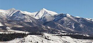
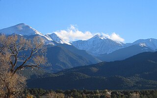
Blanca Peak is the fourth highest summit of the Rocky Mountains of North America and the U.S. state of Colorado. The ultra-prominent 14,351-foot (4,374 m) peak is the highest summit of the Sierra Blanca Massif, the Sangre de Cristo Range, and the Sangre de Cristo Mountains. The fourteener is located 9.6 miles (15.5 km) north by east of the Town of Blanca, on the drainage divide separating Rio Grande National Forest and Alamosa County from the Sangre de Cristo Land Grant and Costilla County. The summit is the highest point of both counties and the entire drainage basin of the Rio Grande. Below the steep North Face of Blanca Peak two live Glaciers once developed, until extinction sometime after 1903. North & South Blanca Glaciers were located at 37° 35N.,longitude 105° 28W. Blanca Peak is higher than any point in the United States east of its longitude.

<span class="mw-page-title-main">Crestone Peak</span> Mountain in the state of Colorado, United States

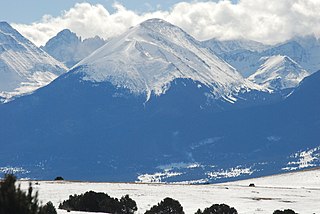
Crestone Peak is the seventh-highest summit of the Rocky Mountains of North America and the U.S. state of Colorado. The prominent 14,296.8-foot (4,358 m) fourteener is the highest summit of the Crestones and the second-highest summit in the Sangre de Cristo Range after Blanca Peak. The summit is located in the Sangre de Cristo Wilderness of Rio Grande National Forest, 5.0 miles (8.1 km) east by south of the Town of Crestone in Saguache County, Colorado, United States.

<span class="mw-page-title-main">Ellingwood Point</span> Mountain in Colorado, United States

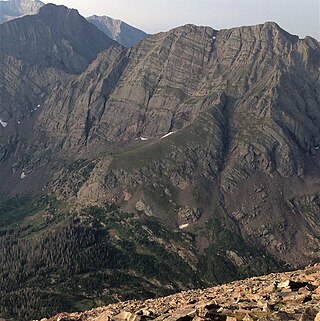
Ellingwood Point is a high mountain summit in the Sangre de Cristo Range of the Rocky Mountains of North America. The 14,048-foot (4,282 m) fourteener is located on the Sierra Blanca Massif, 9.9 miles (16.0 km) north by east of the Town of Blanca, Colorado, United States, on the drainage divide separating the Rio Grande National Forest and Alamosa County from the San Isabel National Forest and Huerfano County. Ellingwood Point was named in honor of Albert Russell Ellingwood, an early pioneer of mountain climbing in the Western United States and in Colorado in particular.

<span class="mw-page-title-main">Hunts Peak</span> Mountain in the state of Colorado

Hunts Peak is a 13,071-foot (3,984 m) mountain summit on the boundary shared by Fremont County and Saguache County, in Colorado, United States.

<span class="mw-page-title-main">Mount Otto</span> Mountain in the state of Colorado

Mount Otto is a 12,865-foot (3,921 m) mountain summit on the boundary shared by Fremont County and Saguache County, in Colorado, United States.

<span class="mw-page-title-main">Galena Peak</span> Mountain in the state of Colorado

Galena Peak is a 12,461-foot (3,798 m) mountain summit on the boundary shared by Fremont County and Saguache County, in Colorado, United States.

<span class="mw-page-title-main">Horn Peak</span> Mountain in the state of Colorado

Horn Peak is a 13,450-foot (4,100 m) mountain summit in Custer County, Colorado, United States.

<span class="mw-page-title-main">Spread Eagle Peak</span> Mountain in the state of Colorado

Spread Eagle Peak is a 13,423-foot (4,091 m) mountain summit in Custer County, Colorado, United States.

<span class="mw-page-title-main">Colony Baldy</span> Mountain in Colorado, United States

Colony Baldy is a 13,705-foot (4,177 m) mountain summit in Custer County, Colorado, United States.

<span class="mw-page-title-main">Broken Hand Peak</span> Mountain in the state of Colorado

Broken Hand Peak is a 13,573-foot (4,137 m) mountain summit on the boundary shared by Custer and Saguache counties, in Colorado, United States.

<span class="mw-page-title-main">Pico Aislado</span>

Pico Aislado is a 13,611-foot (4,149 m) mountain summit in Saguache County, Colorado, United States.

<span class="mw-page-title-main">Cleveland Peak</span> Mountain in Colorado, United States

Cleveland Peak is a 13,414-foot (4,089 m) mountain summit in Saguache County, Colorado, United States.

<span class="mw-page-title-main">Milwaukee Peak</span> Mountain in Colorado, United States

Milwaukee Peak is a 13,522-foot (4,122 m) mountain summit in Saguache County, Colorado, United States.

<span class="mw-page-title-main">Eureka Mountain (Colorado)</span> Mountain in the state of Colorado

Eureka Mountain is a 13,507-foot (4,117 m) mountain summit on the boundary shared by Custer and Saguache counties, in Colorado, United States.

<span class="mw-page-title-main">Electric Peak (Sangre de Cristo)</span> Mountain in the state of Colorado

Electric Peak is a 13,598-foot (4,145 m) mountain summit on the boundary shared by Custer and Saguache counties, in Colorado, United States.

<span class="mw-page-title-main">Cottonwood Peak (Colorado)</span> Mountain peak in the Rockies

Cottonwood Peak is a 13,588-foot (4,142 m) mountain summit on the boundary shared by Custer and Saguache counties, in Colorado, United States.

<span class="mw-page-title-main">Fluted Peak (Colorado)</span> Mountain in the state of Colorado

Fluted Peak is a 13,554-foot (4,131 m) mountain summit on the boundary shared by Custer and Saguache counties, in Colorado, United States.

<span class="mw-page-title-main">Gold Hill (New Mexico)</span>

Gold Hill is a 12,716-foot elevation (3,876 m) mountain summit in Taos County, New Mexico, United States.

<span class="mw-page-title-main">Lake Fork Peak</span> Mountain summit in Taos County, New Mexico

Lake Fork Peak is a 12,881-foot-elevation (3,926 m) mountain summit in Taos County, New Mexico, United States.

<span class="mw-page-title-main">Pueblo Peak</span> Mountain in New Mexico, United States

Pueblo Peak is a 12,303-foot-elevation (3,750-meter) summit in Taos County, New Mexico, United States.

References

  1. 1 2 Robert M. Ormes (2000), Guide to the Colorado Mountains, Colorado Mountain Club Press, ISBN   9780967146607, p. 122.
  2. 1 2 3 4 5 "Twin Peaks, North – 13,584' CO". listsofjohn.com. Retrieved May 31, 2023.
  3. 1 2 "Twin Peaks". Geographic Names Information System . United States Geological Survey, United States Department of the Interior . Retrieved May 31, 2023.
  4. 1 2 "Twin Peaks, Colorado". Peakbagger.com. Retrieved May 31, 2023.
  5. Peel, M. C.; Finlayson, B. L.; McMahon, T. A. (2007). "Updated world map of the Köppen−Geiger climate classification". Hydrol. Earth Syst. Sci. 11 (5): 1633. Bibcode:2007HESS...11.1633P. doi: 10.5194/hess-11-1633-2007 . ISSN   1027-5606.