Walnut Creek (California)

Last updated
Walnut Creek
Arroyo de Las Nueces, [1] Arroyo de Los Nogales [1]
Great Egret on Secondary Beaver Dam lower Walnut Creek Courtesy Cheryl Reynolds 2013.jpg
Secondary beaver dam on lower Walnut Creek provides happy hunting perch for a great egret. Courtesy Cheryl Reynolds, Worth a Dam, 2013
Relief map of California.png
Red pog.svg
Location of the mouth of Walnut Creek in California
Location
Country United States
State California
Region Contra Costa County
Cities Walnut Creek, Pleasant Hill, Four Corners, Concord, Pacheco, Vine Hill, Mococo, Martinez
Physical characteristics
SourceConfluence of Las Trampas Creek and Tice Creek
  location Walnut Creek, California 375338N 1220335W
  coordinates 37°53′38″N122°3′35″W / 37.89389°N 122.05972°W / 37.89389; -122.05972 [2]
  elevation144 ft (44 m)
Mouth Suisun Bay
  location
Martinez, California
  coordinates
38°1′27″N122°4′13″W / 38.02417°N 122.07028°W / 38.02417; -122.07028 [2]
  elevation
2 ft (0.61 m)
Basin size146 sq mi (380 km2)

The Walnut Creek mainstem is a 12.3-mile-long (19.8-kilometer) [3] northward-flowing stream in northern California. The Walnut Creek watershed lies in central Contra Costa County, California and drains the west side of Mount Diablo and the east side of the East Bay Hills. [4] The Walnut Creek mainstem is now mostly a concrete or earthen flood control channel until it reaches Pacheco Creek [5] on its way to Suisun Bay. Walnut Creek was named for the abundant native Northern California walnut trees (Juglans hindsii) which lined its banks historically. The city of Walnut Creek, California was named for the creek when its post office was established in the 1860s. [1]

Contents

History

There are three bands of Bay Miwok Native Americans associated with early Walnut Creek, the stream for which the city of Walnut Creek is named: [6] [7] the Saclan, whose territory extended through the hills east of present-day Oakland, Rossmoor, Lafayette, Moraga and Walnut Creek; the Volvon (also spelled Bolbon, Wolwon and Zuicun) near Mt. Diablo; and the Tactan located on the San Ramon Creek in Danville and Walnut Creek.

Today's Walnut Creek is located within the earlier site of four Mexican land grants. One of these land grants  measuring 18,000 acres (73 square kilometers)  belonged to Juana Sanchez de Pacheco, who eventually passed the land down to her two grandsons. Ygnacio Sibrian, one of the grandsons, created the first roofed home in the valley in about 1850. The grant was called Rancho Arroyo de Las Nueces y Bolbones, named after the principal waterway, Arroyo de Las Nueces (Walnut Creek), as well as for the local group of indigenous Americans (Bolbones). The Arroyo de Las Nueces or Arroyo de Los Nogales referred to the plentiful Northern California walnut trees on its banks.

The first town settler was William Slusher, who built a dwelling on the bank of Walnut Creek, which was called "Nuts Creek" by the Americans in 1849. [8]

Watershed and course

The Walnut Creek watershed basin is 146 square miles (380 square kilometers) and consists of five sub-watersheds: the Clayton Valley Drain, Pine Creek Watershed, San Ramon Creek Watershed, Las Trampas Creek Watershed, and Grayson Creek Watershed. [9] While the mainstem Walnut Creek flows through densely urbanized areas, the upper watersheds of its tributaries generally remain undeveloped open space. Las Trampas Creek drains 27 square miles (70 km2) of Lafayette, Orinda, Moraga, and unincorporated lands in the western Walnut Creek watershed. Lafayette Creek emerges from Lafayette Reservoir to join Las Trampas Creek in Lafayette. Tice Creek joins Las Trampas Creek from the right (heading downstream) to form the Walnut Creek mainstem. Next, San Ramon Creek joins the mainstem Walnut Creek underground near the intersection of Mount Diablo Boulevard and Broadway. The San Ramon Creek subwatershed begins at the northern border of the city of San Ramon's border with Danville and flows northwards through the San Ramon Valley. San Ramon Creek begins as Bollinger Creek, which drains the Las Trampas Regional Wilderness. After becoming San Ramon Creek, the two main tributaries of the 54 square miles (140 km2) San Ramon watershed are Green Valley Creek and Sycamore Creek, which drain the western slopes of Mount Diablo. The next tributary to the Walnut Creek mainstem is Pine Creek, which at 31 square miles (80 km2) is the second largest subwatershed in the basin. Pine Creek drains the west slopes of flows through Mount Diablo State Park, Diablo Foothills Regional Park, and Castle Rock Regional Recreational Area. It is joined by Galindo Creek downstream of Monument Boulevard in Concord, before it joins Walnut Creek. The 9 square miles (23 km2) Clayton Drain drains urbanized Concord through the Clayton Valley. It used to receive flows from Mount Diablo Creek before the latter was diverted into Seal Creek along the east side of the valley The drain enters the Walnut Creek channel just upstream of Highway 4. Lastly, Grayson Creek drains the eastern flank of the Briones Hills and its 23 square miles (60 km2) subwatershed includes Murderer's Creek and Hidden Valley Creek. It joins Walnut Creek from the left just downstream of Highway 4. Shortly thereafter, Walnut Creek ends as it joins Pacheco Creek [5] from the right (heading downstream). From that confluence, Pacheco Creek flows north 4 miles (6.4 kilometers) through the Concord Marsh into Suisun Bay. [9]

Ecology

Walnut Creek is one of the few San Francisco Bay Area coastal watersheds that has extant Chinook salmon (Oncorhynchus tshawytscha) spawning and rearing, in its lower watershed. [10] This is consistent with archeological records of both Chinook and coho salmon (Oncorhynchus kisutch) at CCO-309, a site dating to 1400-1500 C.E. about 12 miles (19 km) upstream from Suisun Bay in the Tice Creek Valley in the Walnut Creek watershed. [11] [12]

See also

Related Research Articles

<span class="mw-page-title-main">Contra Costa County, California</span> County in California, United States

Contra Costa County is a county located in the U.S. state of California, in the East Bay of the San Francisco Bay Area. As of the 2020 United States Census, the population was 1,165,927. The county seat is Martinez. It occupies the northern portion of the East Bay region of the San Francisco Bay Area and is primarily suburban. The county's name refers to its position on the other side of the bay from San Francisco. Contra Costa County is included in the San Francisco–Oakland–Berkeley, CA Metropolitan Statistical Area.

<span class="mw-page-title-main">Alamo, California</span> Unincorporated community in California, United States

Alamo is an unincorporated community and census-designated place (CDP) in Contra Costa County, California, in the United States. It is a suburb located in the San Francisco Bay Area's East Bay region, approximately 28 miles (45 km) east of San Francisco. Alamo is equidistant from the city of Walnut Creek and the incorporated town of Danville. As of the 2020 census, the population was 15,314.

<span class="mw-page-title-main">Walnut Creek, California</span> City in California, United States

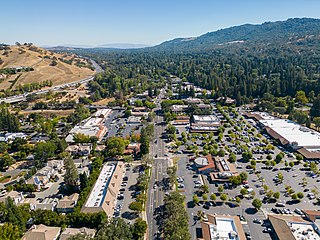
Walnut Creek is a city in Contra Costa County, California, United States, located in the East Bay region of the San Francisco Bay Area, about 16 miles east of the city of Oakland. Walnut Creek has a total population of 70,127 per the 2020 census, is located at the junction of the highways from Sacramento and San Jose (I-680) and San Francisco/Oakland (SR-24), and is accessible by BART. The city shares its borders with Clayton, Lafayette, Alamo, Pleasant Hill, and Concord.

The San Ramon Valley is a valley and region in Contra Costa County and Alameda County, in the East Bay region of the San Francisco Bay Area in northern California.

<span class="mw-page-title-main">Alameda Creek</span> River in California, United States

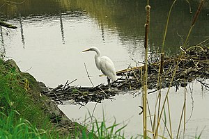
Alameda Creek is a large perennial stream in the San Francisco Bay Area. The creek runs for 45 miles (72 km) from a lake northeast of Packard Ridge to the eastern shore of San Francisco Bay by way of Niles Canyon and a flood control channel. Along its course, Alameda Creek provides wildlife habitat, water supply, a conduit for flood waters, opportunities for recreation, and a host of aesthetic and environmental values. The creek and three major reservoirs in the watershed are used as water supply by the San Francisco Public Utilities Commission, Alameda County Water District and Zone 7 Water Agency. Within the watershed can be found some of the highest peaks and tallest waterfall in the East Bay, over a dozen regional parks, and notable natural landmarks such as the cascades at Little Yosemite and the wildflower-strewn grasslands and oak savannahs of the Sunol Regional Wilderness. After an absence of half a century, ocean-run steelhead trout are able to return to Alameda Creek to mingle with remnant rainbow trout populations. Completion of a series of dam removal and fish passage projects, along with improved stream flows for cold-water fish and planned habitat restoration, enable steelhead trout and Chinook salmon to access up to 20 miles (32 km) of spawning and rearing habitat in Alameda Creek and its tributaries. The first juvenile trout migrating downstream from the upper watershed through lower Alameda Creek toward San Francisco Bay was detected and documented in April 2023.

<span class="mw-page-title-main">John A. Nejedly</span> American politician

John Albert Nejedly was a district attorney and Republican state senator in California who represented Contra Costa County from 1958 to 1980.

<span class="mw-page-title-main">Pacheco Creek (Contra Costa County)</span>

Pacheco Creek is a 3.4-mile-long (5.5 km) waterway in central Contra Costa County, California, United States. It empties into Suisun Bay. It is formed by the intersection of Walnut Creek, Grayson Creek and Pine Creek.

<span class="mw-page-title-main">Rancho Arroyo de Las Nueces y Bolbones</span> Mexican land grant in Contra Costa County, California

Rancho Arroyo de Las Nueces y Bolbones was a 17,782-acre (71.96 km2) Mexican land grant in present-day Contra Costa County, California given in 1834 by Governor José Figueroa to Juana Sanchez de Pacheco.

Grayson Creek is a stream in Contra Costa County in northern California that flows northeasterly 7.4 miles (11.9 km) from its origin in Briones Regional Park to Pacheco Slough four miles east of Martinez. Pacheco Slough, in turn, connects to Suisun Bay. The Grayson Creek subwatershed is part of the Walnut Creek watershed and includes the cities of Pleasant Hill and Pacheco, California.

The Saklan are a tribe of the Native American Miwok community, based just south of San Pablo and Suisun Bays, in Contra Costa County, California. Their historical tribal lands ranged from Moraga, to San Leandro Creek, to Lafayette.

<span class="mw-page-title-main">Las Trampas Creek</span> River in California, United States

Las Trampas Creek is a 12.37 mile long north-east flowing stream in Contra Costa County, California. Its watershed comprises an area of 17,238 acres. It's mean daily flow is approximately 15.4 cfs.

<span class="mw-page-title-main">Grizzly Creek, Contra Costa County</span> Stream in California, US

Grizzly Creek is a 3.2-mile-long northwest-flowing perennial stream in Contra Costa County, California. It is a major tributary of Las Trampas Creek, which is part of the larger Walnut Creek watershed, which in turn drains into Suisun Bay.

<span class="mw-page-title-main">Las Trampas Peak</span> Mountain in SF Bay Area Coast Ranges

Las Trampas Peak is a 1,827 ft (557 m) peak in the Inner Coast Ranges in western Contra Costa County, California, in the San Francisco Bay Area.

<span class="mw-page-title-main">Rocky Ridge (California)</span> Mountain in SF Bay Area

Rocky Ridge is a 2,020 ft (620 m) ridge in the Inner Coast Ranges in western Contra Costa County, California, in the San Francisco Bay Area. Being the second-highest mountain in the county, it is visible from much of the surrounding area. The ridge is a very prominent feature in the geography of the towns of Lafayette, Moraga and Orinda, California.

<span class="mw-page-title-main">Lafayette Creek (California)</span> Stream in Contra Costa County


Lafayette Creek is a 3.78 mi (6.08 km) long creek in Contra Costa County, California in the San Francisco Bay Area. It is a tributary of Las Trampas Creek.

<span class="mw-page-title-main">Tice Creek</span> River

Tice Creek is a minor creek in Contra Costa County, California in the San Francisco Bay Area. It is approximately 4.1 miles (6.6 km) long. It is a tributary of Las Trampas Creek, which itself is a major tributary to Walnut Creek which in turn drains into Suisun Bay. The name comes from the surname of a settler family who settled in the Tice valley.

<span class="mw-page-title-main">Bollinger Canyon Creek</span> Creek in Central California

Bollinger Canyon Creek is an approximately 6.72-mile-long stream in Contra Costa County, California in the San Francisco Bay Area. It is a tributary of San Ramon Creek which is part of the Walnut Creek watershed. The creek derives its name from the surname of a family who settled in the area in the 19th century.

<span class="mw-page-title-main">Buckhorn Creek (California)</span> Creek in Central California

Buckhorn Creek is a 2.1 mile long creek in Contra Costa County, California, in the San Francisco Bay Area. It gets its name from the Buckhorn family who settled on the creek in the late 19th century.

<span class="mw-page-title-main">Las Trampas Ridge</span>

Las Trampas Ridge is an 1,827 ft ridge in western Contra Costa County, California, in the San Francisco Bay Area. It comprises the western side of the San Ramon Valley.

Mount Diablo Creek is a 14.3-mile-long (23.0 km) northwest-flowing stream originating on the north flank of Mount Diablo. Its dozen small tributaries gather near Clayton before flowing through Concord and the Concord Naval Weapons Station, ultimately ending in tidelands on the southern shore of Suisun Bay in Contra Costa County. If the Concord Naval Weapons Station is converted to protected wildlands, Mount Diablo Creek may serve as the last wildlife corridor for black-tailed deer, tule elk, and other mammals from Mount Diablo to Suisun Bay.

References

  1. 1 2 3 Gudde, Erwin G. (1949). California Place Names: A Geographical Dictionary. Berkeley, California: University of California Press.
  2. 1 2 U.S. Geological Survey Geographic Names Information System: Walnut Creek
  3. U.S. Geological Survey. National Hydrography Dataset high-resolution flowline data. The National Map, accessed October 20, 2020
  4. Contra Costa County Watershed Atlas (PDF) (Report). Martinez, California: Contra Costa County Community Development Department. November 2003. Archived from the original (PDF) on 2020-10-29. Retrieved October 29, 2020.
  5. 1 2 U.S. Geological Survey Geographic Names Information System: Pacheco Creek
  6. Forester, Maria (2006). The Bay Miwok of Contra Costa County (Report). Retrieved October 20, 2020.
  7. Randall Milliken; Laurence H. Shoup; Beverly R. Ortiz (June 1, 2009). Ohlone/Costanoan Indians of the San Francisco Peninsula and their Neighbors, Yesterday and Today (PDF) (Report). Golden Gate National Recreation Area, San Francisco, California: National Park Service. Retrieved October 20, 2020.
  8. History of Contra Costa County, California. Contra Costa County, California: Brooks-Sterling Company. 1882. p. 444.
  9. 1 2 Rich Walkling; et al. (Restoration Design Group) (February 2013). Walnut Creek Watershed Inventory (PDF) (Report). Walnut Creek Watershed Council. Archived from the original (PDF) on 2020-10-26. Retrieved October 20, 2020.
  10. Leidy, Robert A. (2007). Ecology, Assemblage Structure, Distribution, and Status of Fishes in Streams Tributary to the San Francisco Estuary, California, SFEI Contribution No. 530 (Report). San Francisco Estuary Institute. p. 194.
  11. Kenneth W. Gobalet (1992). "Inland Utilization of Marine Fishes by Native Americans along the Central California Coast". Journal of California and Great Basin Anthropology. 14 (1): 72–84. JSTOR   27825478.
  12. Kenneth W. Gobalet; Peter D. Schulz; Thomas A. Wake; Nelson Siefkin (2004). "Archaeological Perspectives on Native American Fisheries of California, with Emphasis on Steelhead and Salmon". Transactions of the American Fisheries Society. 133 (4): 801–833. doi:10.1577/T02-084.1.