Benton County | |
---|---|
Coordinates: 42°04′47″N92°04′03″W / 42.079722222222°N 92.0675°W | |
Country | United States |
State | Iowa |
Founded | 1837 |
Named for | Thomas Hart Benton |
Seat | Vinton |
Largest city | Vinton |
Area | |
• Total | 718 sq mi (1,860 km2) |
• Land | 716 sq mi (1,850 km2) |
• Water | 2.2 sq mi (6 km2) 0.3% |
Population (2020) | |
• Total | 25,575 |
• Density | 36/sq mi (14/km2) |
Time zone | UTC−6 (Central) |
• Summer (DST) | UTC−5 (CDT) |
Congressional district | 1st |
Website | www |
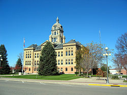
Benton County is a county in the U.S. state of Iowa. As of the 2020 census, the population was 25,575. [1] Its county seat and largest city is Vinton. [2] The county is named for Thomas Hart Benton, a U.S. Senator from Missouri.
Benton County is part of the Cedar Rapids, IA Metropolitan Statistical Area. [3]
Benton County was formed on December 21, 1837, from sections of Dubuque County. It was named after US Senator Thomas Hart Benton. [4]
According to the U.S. Census Bureau, the county has a total area of 718 square miles (1,860 km2), of which 716 square miles (1,850 km2) is land and 2.2 square miles (5.7 km2) (0.3%) is water. [5]
Census | Pop. | Note | %± |
---|---|---|---|
1850 | 672 | — | |
1860 | 8,496 | 1,164.3% | |
1870 | 22,454 | 164.3% | |
1880 | 24,888 | 10.8% | |
1890 | 24,178 | −2.9% | |
1900 | 25,177 | 4.1% | |
1910 | 23,156 | −8.0% | |
1920 | 24,080 | 4.0% | |
1930 | 22,851 | −5.1% | |
1940 | 22,879 | 0.1% | |
1950 | 22,656 | −1.0% | |
1960 | 23,422 | 3.4% | |
1970 | 22,885 | −2.3% | |
1980 | 23,649 | 3.3% | |
1990 | 22,429 | −5.2% | |
2000 | 25,308 | 12.8% | |
2010 | 26,076 | 3.0% | |
2020 | 25,575 | −1.9% | |
2023 (est.) | 25,796 | [6] | 0.9% |
U.S. Decennial Census [7] 1790-1960 [8] 1900-1990 [9] 1990-2000 [10] 2010-2018 [11] |
The 2020 census recorded a population of 25,575 in the county, with a population density of 35.6124/sq mi (13.75001/km2). 96.29% of the population reported being of one race. 93.04% were non-Hispanic White, 0.45% were Black, 1.81% were Hispanic, 0.13% were Native American, 0.32% were Asian, 0.01% were Native Hawaiian or Pacific Islander and 4.24% were some other race or more than one race. There were 11,076 housing units of which 10,282 were occupied. [1]
The 2010 census recorded a population of 26,076 in the county, with a population density of 36.419/sq mi (14.061/km2). There were 11,095 housing units, of which 10,302 were occupied. [12]
As of the census [13] of 2000, there were 25,308 people, 9,746 households, and 7,056 families residing in the county. The population density was 35 inhabitants per square mile (14/km2). There were 10,377 housing units at an average density of 14 per square mile (5.4/km2). The racial makeup of the county was 98.84% White, 0.20% Black or African American, 0.15% Native American, 0.17% Asian, 0.02% Pacific Islander, 0.11% from other races, and 0.52% from two or more races. 0.62% of the population were Hispanic or Latino of any race.
There were 9,746 households, out of which 34.90% had children under the age of 18 living with them, 62.70% were married couples living together, 6.5% had a female householder with no husband present, and 27.6% were non-families. 23.4% of all households were made up of individuals, and 11.70% had someone living alone who was 65 years of age or older. The average household size was 2.56 and the average family size was 3.04.
In the county, the population was spread out, with 27.4% under the age of 18, 6.8% from 18 to 24, 29.3% from 25 to 44, 21.1% from 45 to 64, and 15.4% who were 65 years of age or older. The median age was 37 years. For every 100 females, there were 100.0 males. For every 100 females age 18 and over, there were 95.8 males.
The median income for a household in the county was $42,427, and the median income for a family was $49,701. Males had a median income of $35,044 versus $23,978 for females. The per capita income for the county was $18,891. About 4.6% of families and 6.1% of the population were below the poverty line, including 7.2% of those under age 18 and 7.0% of those age 65 or over.
Benton County is divided into twenty townships:
The population ranking of the following table is based on the 2020 census of Benton County. [1]
†county seat
Rank | City/Town/etc. | Municipal type | Population (2020 Census) |
---|---|---|---|
1 | † Vinton | City | 4,938 |
2 | Belle Plaine | City | 2,330 |
3 | Atkins | City | 2,056 |
4 | Urbana | City | 1,554 |
5 | Walford (partially in Linn County ) | City | 1,366 |
6 | Shellsburg | City | 961 |
7 | Blairstown | City | 692 |
8 | Newhall | City | 876 |
9 | Van Horne | City | 713 |
10 | Keystone | City | 599 |
11 | Norway | City | 466 |
12 | Garrison | City | 344 |
13 | Mount Auburn | City | 162 |
14 | Watkins | CDP | 116 |
15 | Luzerne | City | 112 |
Year | Republican | Democratic | Third party(ies) | |||
---|---|---|---|---|---|---|
No. | % | No. | % | No. | % | |
2024 | 9,549 | 65.81% | 4,739 | 32.66% | 221 | 1.52% |
2020 | 9,188 | 62.75% | 5,160 | 35.24% | 294 | 2.01% |
2016 | 8,232 | 59.46% | 4,678 | 33.79% | 934 | 6.75% |
2012 | 6,940 | 49.49% | 6,862 | 48.93% | 221 | 1.58% |
2008 | 6,447 | 47.00% | 7,058 | 51.45% | 212 | 1.55% |
2004 | 6,658 | 49.31% | 6,747 | 49.97% | 96 | 0.71% |
2000 | 5,468 | 46.47% | 5,915 | 50.27% | 383 | 3.26% |
1996 | 3,835 | 37.31% | 5,546 | 53.95% | 898 | 8.74% |
1992 | 3,469 | 33.23% | 4,467 | 42.79% | 2,503 | 23.98% |
1988 | 4,011 | 40.20% | 5,873 | 58.87% | 93 | 0.93% |
1984 | 5,566 | 52.13% | 4,993 | 46.76% | 119 | 1.11% |
1980 | 5,329 | 50.11% | 4,223 | 39.71% | 1,083 | 10.18% |
1976 | 5,014 | 46.85% | 5,514 | 51.52% | 175 | 1.64% |
1972 | 5,273 | 54.09% | 4,282 | 43.92% | 194 | 1.99% |
1968 | 5,016 | 52.06% | 3,944 | 40.93% | 675 | 7.01% |
1964 | 3,453 | 34.24% | 6,614 | 65.59% | 17 | 0.17% |
1960 | 5,972 | 56.33% | 4,620 | 43.58% | 9 | 0.08% |
1956 | 5,634 | 56.31% | 3,946 | 39.44% | 426 | 4.26% |
1952 | 6,316 | 59.09% | 3,831 | 35.84% | 542 | 5.07% |
1948 | 3,770 | 45.06% | 4,209 | 50.30% | 388 | 4.64% |
1944 | 4,378 | 48.43% | 4,619 | 51.10% | 42 | 0.46% |
1940 | 5,298 | 49.55% | 5,363 | 50.15% | 32 | 0.30% |
1936 | 4,144 | 41.72% | 5,606 | 56.43% | 184 | 1.85% |
1932 | 3,424 | 34.87% | 6,070 | 61.82% | 325 | 3.31% |
1928 | 5,669 | 62.68% | 3,307 | 36.56% | 69 | 0.76% |
1924 | 5,314 | 58.13% | 1,459 | 15.96% | 2,369 | 25.91% |
1920 | 6,539 | 71.02% | 2,343 | 25.45% | 325 | 3.53% |
1916 | 3,189 | 54.16% | 2,556 | 43.41% | 143 | 2.43% |
1912 | 1,831 | 31.53% | 2,472 | 42.56% | 1,505 | 25.91% |
1908 | 3,180 | 55.08% | 2,418 | 41.88% | 175 | 3.03% |
1904 | 3,609 | 61.10% | 2,057 | 34.82% | 241 | 4.08% |
1900 | 3,609 | 56.89% | 2,575 | 40.59% | 160 | 2.52% |
1896 | 3,604 | 57.50% | 2,560 | 40.84% | 104 | 1.66% |
School districts: [15]
There was formerly a state-operated school, Iowa Braille and Sight Saving School.
Washington County is a county located in the U.S. state of Iowa. As of the 2020 census, the population was 22,565. The county seat is Washington. Washington County is included in the Iowa City Metropolitan Statistical Area.
Taylor County is a county located in the U.S. state of Iowa. As of the 2020 census, the population was 5,896, making it the fourth-least populous county in Iowa. The county seat is Bedford. The county was formed in 1847 and named after General and President Zachary Taylor.
Tama County is a county located in the U.S. state of Iowa. As of the 2020 census, the population was 17,135. Its county seat is Toledo. The county was formed on February 17, 1843 and named for Taimah, a leader of the Meskwaki people.
Polk County is located in the U.S. state of Iowa. As of the 2020 census, the population was 492,401. It is Iowa's most populous county, and home to over 15% of the state's residents. The county seat is Des Moines, which is also the capital city of Iowa. Polk County is included in the Des Moines–West Des Moines, IA Metropolitan Statistical Area.
Kossuth County is a county in the U.S. state of Iowa. As of the 2020 census, the population was 14,828. The county seat is Algona.
Keokuk County is a county located in the U.S. state of Iowa. As of the 2020 United States Census, the population was 10,033. The county seat is Sigourney.
Iowa County is a county located in the U.S. state of Iowa. As of the 2020 census, the population was 16,662. The county seat is Marengo.
Henry County is a county located in the U.S. state of Iowa. As of the 2020 census, the population was 20,482. The county seat is Mount Pleasant. The county was named for General Henry Dodge, governor of Wisconsin Territory.
Buchanan County is a county located in the U.S. state of Iowa. As of the 2020 census, the population was 20,565. Its county seat is Independence. The county was created in 1837 and was named in honor of Senator James Buchanan, the 15th President of the United States.
Belle Plaine is a city in Benton County, Iowa, United States. The population was 2,330 at the 2020 census. It is part of the Cedar Rapids Metropolitan Statistical Area.
Garrison is a city in Benton County, Iowa, United States. The population was 344 at the time of the 2020 census. It is part of the Cedar Rapids Metropolitan Statistical Area.
Norway is a city in Benton County, Iowa, United States. The population was 466 at the time of the 2020 census. The city is approximately 17 miles (27 km) southwest of downtown Cedar Rapids. It is part of the Cedar Rapids Metropolitan Statistical Area. Norway is the setting of the movie The Final Season.
Shellsburg is a city in Benton County, Iowa, United States. The population was 961 at the time of the 2020 census. It is part of the Cedar Rapids Metropolitan Statistical Area.
Urbana is a city in Benton County, Iowa, United States. The population was 1,554 at the time of the 2020 census. It is part of the Cedar Rapids Metropolitan Statistical Area.
Vinton is a city in Benton County, Iowa, United States. The population was 4,938 in the 2020 census, a decrease from 5,102 in 2000. It is also part of the Cedar Rapids Metropolitan Statistical Area. Vinton is the county seat of Benton County.
Mount Ayr is a city in Ringgold County, Iowa, United States. The population was 1,623 at the time of the 2020 census. Mount Ayr is a rural community in southwestern Iowa, 22 miles west of Interstate 35 on State Highway 2. Mount Ayr was founded in 1875 and the community was named in honor of poet Robert Burns’ birthplace in Ayr, Scotland. The “mount” was added to indicate its location on the highest point of land in the area.
Colo is a city in Story County, Iowa, United States. The population was 845 at the 2020 census. The town is home to the "Crossroads of the Nation" as Lincoln Highway and Jefferson Highway intersect at Colo. It is part of the Ames, Iowa Metropolitan Statistical Area, which is a part of the larger Ames-Boone, Iowa Combined Statistical Area.
Canton Township is one of twenty townships in Benton County, Iowa, United States. As of the 2000 census, its population was 847.
Taylor Township is one of twenty townships in Benton County, Iowa, United States. As of the 2000 census, its population was 781.
Watkins is an unincorporated community and census-designated place in southeastern Benton County, Iowa, United States. As of the 2020 census, it had a population of 116. Watkins lies along local roads south of the city of Vinton, the county seat of Benton County. Its elevation is 830 feet (250 m) above sea level. Although Watkins is unincorporated, it has a post office, with the ZIP code of 52354, which opened on 15 December 1873.