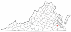
Dendron, Virginia

Last updated

Dendron, Virginia
VAMap-doton-Dendron.PNG
Location of Dendron, Virginia
Coordinates: 37°2′40″N76°56′5″W / 37.04444°N 76.93472°W / 37.04444; -76.93472
Country United States
State Virginia
County Surry
Area
[1]
  Total3.57 sq mi (9.24 km2)
  Land3.57 sq mi (9.24 km2)
  Water0.00 sq mi (0.00 km2)
Elevation
118 ft (36 m)
Population
 (2020) [2]
  Total251
  Density70/sq mi (27/km2)
Time zone UTC-5 (Eastern (EST))
  Summer (DST) UTC-4 (EDT)
ZIP code
23839
Area code(s) 757, 948
FIPS code 51-22160 [3]
GNIS feature ID1492862 [4]

Dendron is a town in Surry County, Virginia, United States. The population was 251 at the 2010 census. [5] Sculptor Leslie Garland Bolling was born in Dendron, as was mayor of Hopewell, Virginia, Curtis W. Harris.

Contents

Geography

Dendron is located at 37°2′40″N76°56′5″W / 37.04444°N 76.93472°W / 37.04444; -76.93472 (37.044516, -76.934737). [6]

According to the United States Census Bureau, the town has a total area of 3.6 square miles (9.2 km2), all land.

History

Dendron was originally a mill town, built and run by the Surry Lumber Company in to house employees of its sawmill. The village was known as Mussel Fork Village until 1896 when it was renamed "Dendron." The name was derived from δένδρον, the Greek word for tree. The years after 1896 saw rapid growth and expansion of the sawmill and the town. More people moved to Dendron and additional Company housing was built. By 1906, Dendron had a population of 1513 people, 298 dwellings, two hotels, eighteen Company stores and five churches. By 1928, Dendron's population had reached nearly 3,000 people. In addition to those establishments listed above, there was also a post office, two schools, a jail, two banks, two doctors, a skating rink, a movie theater, and a number of non-company owned businesses; such as a drug store, barber shops, garages, cleaning establishments, a pool room, a restaurant, bakery and an ice cream parlor.

The company also operated a narrow gauge railroad known as Sussex, Surry and Southampton Railway that transported logs to its sawmill in Dendron, and lumber to its wharf on the James River. It also offered passenger service to Dendron and other small towns along its route. One of its steam locomotives built in 1891 was sold to Argent Lumber company in 1926. It was later bought by Midwest Central Railroad in 1960. Completely restored it is still in operation as Midwest Central Railroad's flagship locomotive.

Production peaked in 1920, and the company did not replant after it cut trees. By 1925, most of the area's old growth timber was exhausted. The Surry Lumber Company shut its Dendron sawmills on October 27, 1927. With its major employer gone, the town lost population rapidly, as did nearby Sedley, Vicksville, and Central Hill. The following year, the company began dismantling and selling its equipment and buildings, leaving Dendron without a railroad, water system or electricity. [7]

In February 1931, a fire swept through what was left of Dendron, destroying twenty-one buildings along Main Street and erasing much of what was left of the once prosperous town. A decade later, the rival Gray Lumber Company of Waverly, which had long replanted its land with pine seedlings, bought 15,000 acres from the nearly defunct Surry Lumber company, and three other companies soon bought most of the remaining acreage in other counties. The company's headquarters in Dendron was razed in 1970, and the former commissary, converted into a store, burned down in 1989. [7]

Demographics

Historical population
CensusPop.Note
1910 1,653
1920 1,7053.1%
1930 671−60.6%
1940 465−30.7%
1950 4762.4%
1960 403−15.3%
1970 336−16.6%
1980 307−8.6%
1990 305−0.7%
2000 297−2.6%
2010 272−8.4%
2020 251−7.7%
U.S. Decennial Census [8]

2020 census

Dendron, Virginia – Racial and Ethnic Composition
(NH = Non-Hispanic)
Note: the US Census treats Hispanic/Latino as an ethnic category. This table excludes Latinos from the racial categories and assigns them to a separate category. Hispanics/Latinos may be of any race.
Race / EthnicityPop 2010 [9] Pop 2020 [2] % 2010% 2020
White alone (NH)10110237.13%40.64%
Black or African American alone (NH)15614157.35%56.18%
Native American or Alaska Native alone (NH)210.74%0.40%
Asian alone (NH)000.00%0.00%
Pacific Islander alone (NH)000.00%0.00%
Some Other Race alone (NH)010.00%0.40%
Mixed Race/Multi-Racial (NH)501.84%0.00%
Hispanic or Latino (any race)862.94%2.39%
Total272251100.00%100.00%

2000 Census

At the 2000 census there were 297 people, 106 households, and 75 families in the town. The population density was 83.3 people per square mile (32.1/km2). There were 121 housing units at an average density of 33.9 per square mile (13.1/km2). The racial makeup of the town was 48.82% White and 51.18% African American. Hispanic or Latino of any race were 1.01%. [3]

Of the 106 households 33.0% had children under the age of 18 living with them, 47.2% were married couples living together, 15.1% had a female householder with no husband present, and 29.2% were non-families. 25.5% of households were one person and 17.9% were one person aged 65 or older. The average household size was 2.80 and the average family size was 3.40.

The age distribution was 24.9% under the age of 18, 8.8% from 18 to 24, 22.9% from 25 to 44, 23.9% from 45 to 64, and 19.5% 65 or older. The median age was 38 years. For every 100 females there were 78.9 males. For every 100 females age 18 and over, there were 78.4 males.

The median household income was $41,667 and the median family income was $46,875. Males had a median income of $35,625 versus $20,000 for females. The per capita income for the town was $15,643. About 3.3% of families and 3.9% of the population were below the poverty line, including 2.9% of those under the age of eighteen and 5.0% of those sixty five or over.

Related Research Articles

<span class="mw-page-title-main">Choctaw County, Alabama</span> County in Alabama, United States

Choctaw County is a county located in the southwestern portion of the U.S. state of Alabama. As of the 2020 census, the population was 12,665. The county seat is Butler. The county was established on December 29, 1847, and named for the Choctaw tribe of Native Americans.

<span class="mw-page-title-main">Houston County, Texas</span> County in Texas, United States

Houston County is a county located in the U.S. state of Texas. As of the 2020 census, its population was 22,066. Its county seat is Crockett. Houston County was one of 46 entirely dry counties in the state of Texas, until voters in a November 2007 special election legalized the sale of alcohol in the county.

<span class="mw-page-title-main">Hermitage, Arkansas</span> City in Arkansas, United States

Hermitage is a city in Bradley County, Arkansas, United States. The United States Census Bureau estimated the population to be 830 as of the 2010 census.

<span class="mw-page-title-main">McNary, Louisiana</span> Village in Louisiana, United States

McNary is a village in Rapides Parish, Louisiana, United States. It is part of the Alexandria, Louisiana, Metropolitan Statistical Area. The population was 211 at the 2000 census.

<span class="mw-page-title-main">Phillips, Maine</span> Town in the state of Maine, United States

Phillips is a town in Franklin County, Maine, United States. The population was 898 at the 2020 census. It is home to the Sandy River and Rangeley Lakes Railroad, a heritage railroad.

<span class="mw-page-title-main">Jackman, Maine</span> Town in the state of Maine, United States

Jackman is a town in Somerset County, Maine, United States. The population was 782 at the 2020 census.

<span class="mw-page-title-main">Willow River, Minnesota</span> City in Minnesota, United States

Willow River is a city in Pine County, Minnesota, United States, at the confluence of the Kettle and Willow Rivers. The population was 415 at the 2010 census.

<span class="mw-page-title-main">Hines, Oregon</span> City in Oregon, United States

Hines is a city in Harney County, Oregon, United States. The population was 1,563 at the 2010 census.

<span class="mw-page-title-main">Westfir, Oregon</span> City in Oregon, United States

Westfir is a city in Lane County, Oregon, United States. The population was 253 at the 2010 census. It is located about 40 miles (64 km) southeast of Eugene and about 4 miles (6 km) west of Oakridge in the Willamette National Forest.

<span class="mw-page-title-main">Pineland, Texas</span> City in Texas, United States

Pineland is a city in Sabine County, Texas, United States. The population was 888 at the 2020 census.

<span class="mw-page-title-main">Sharon, Vermont</span> Town in Vermont, United States

Sharon is a town in Windsor County, Vermont, United States. It had a population of 1,560 at the 2020 census.

<span class="mw-page-title-main">Rushmere, Virginia</span> Census-designated place in Virginia, United States

Rushmere is a census-designated place (CDP) in Isle of Wight County, Virginia, United States. The population was 1,018 at the 2010 census.

<span class="mw-page-title-main">Nassawadox, Virginia</span> Town in Virginia, United States

Nassawadox is a town in Northampton County, Virginia, United States. Per the 2020 census, the population was 533. The town, with an area of 0.4 square miles (1.0 km2), is located on U.S. Route 13 on Virginia's Eastern Shore, approximately five miles south of Exmore and 25 miles (40 km) north of the Chesapeake Bay Bridge-Tunnel.

<span class="mw-page-title-main">Claremont, Virginia</span> Town in Virginia, United States

Claremont is an incorporated town in Surry County, Virginia, United States. The population was 378 at the 2010 census. A granite marker stands as a memorial to the arrival of British settlers in the area. It received its name during the colonial era from the royal residence in Surry Shire in England. The town was incorporated in 1886, had a port on the James River, and gained railroad service as a terminus for a while before being abandoned. Claremont was home to the Temperance, Industrial, and Collegiate Institute, a school for African Americans founded by a former slave. The area includes a historical marker commemorating the institution.

<span class="mw-page-title-main">Surry, Virginia</span> Town in Virginia, United States

Surry is an incorporated town in Surry County, Virginia, United States. The population was 244 at the 2010 census. It is the county seat of Surry County. Its name is derived from the historic county of Surrey in England.

<span class="mw-page-title-main">Waverly, Virginia</span> Town in Virginia, United States

Waverly is an incorporated town in Sussex County, Virginia, United States. Per the 2020 census, the population was 1,955.

<span class="mw-page-title-main">Meadow Bridge, West Virginia</span> Town in West Virginia, United States

Meadow Bridge is a town in Fayette County, West Virginia, United States. The population was 379 at the 2010 census. The first settler of the area was John Gwin, closely followed by Dan Griffin.

<span class="mw-page-title-main">Rainelle, West Virginia</span> Town in West Virginia, United States

Rainelle is a town on the western edge of Greenbrier County, West Virginia, United States. It sits at the base of Sewell Mountain and Sims Mountain, and is bisected by the Meadow River. The only means of transportation to and from Rainelle are roads; primarily US 60 and WV 20, which merge on the western end of the town, and the James River and Kanawha Turnpike, which enters from the south. The population was 1,190 at the 2020 census.

<span class="mw-page-title-main">Catawba, Wisconsin</span> Village in Wisconsin, United States

Catawba is a village in Price County, Wisconsin, United States. The population was 110 at the 2010 census. The village is located within the Town of Catawba.

<span class="mw-page-title-main">Surry County, Virginia</span> County in Virginia, United States

Surry County is a county in the Commonwealth of Virginia. As of the 2020 census, the population was 6,561.

References

  1. "2019 U.S. Gazetteer Files". United States Census Bureau. Retrieved August 7, 2020.
  2. 1 2 "P2 HISPANIC OR LATINO, AND NOT HISPANIC OR LATINO BY RACE - 2020: DEC Redistricting Data (PL 94-171) - Dendron town, Virginia". United States Census Bureau .
  3. 1 2 "U.S. Census website". United States Census Bureau . Retrieved January 31, 2008.
  4. "US Board on Geographic Names". United States Geological Survey. October 25, 2007. Retrieved January 31, 2008.
  5. "Dendron town, Virginia". United States Census Bureau . Retrieved January 26, 2022.
  6. "US Gazetteer files: 2010, 2000, and 1990". United States Census Bureau. February 12, 2011. Retrieved April 23, 2011.
  7. 1 2 Jack Huber, "The Surry Lumber Company", Virginia Forests available (Winter 2000) at http://www.rootsweb.ancestry.com/~vaschs/SLCfinal.htm
  8. "Census of Population and Housing from 1790". US Census Bureau . Retrieved January 24, 2022.
  9. "P2 HISPANIC OR LATINO, AND NOT HISPANIC OR LATINO BY RACE - 2010: DEC Redistricting Data (PL 94-171) - Dendron town, Virginia". United States Census Bureau .