Jammu and Kashmir | |
|---|---|
| 1846–1952 | |
 Jammu and Kashmir in 1946 | |
| Status | Princely state |
| Capital | |
| Common languages | |
| Religion | Islam (majority), Hinduism, Buddhism, Jainism, Sikhism |
| Government | Monarchy |
| Maharaja | |
• 1846–1857 | Gulab Singh (first) |
• 1925–1952 | Hari Singh (last) |
| Dewan | |
• 1917–1921 | Daljit Singh (first) |
• 1948–1952 | Sheikh Abdullah (last) |
| History | |
• End of the First Anglo-Sikh War and formation of the state | 1846 |
• End of British Crown Suzerainty | 15 Aug 1947 |
• Beginning of the First Kashmir War | 22 Oct 1947 |
• Accession to the Indian Union | 26–27 Oct 1947 |
| 1 January 1949 | |
• Disestablished | 17 November 1952 |
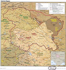
| Today part of | Disputed; see Kashmir conflict |


Jammu and Kashmir, also known as Kashmir and Jammu, [1] was a princely state in a subsidiary alliance with the British East India Company from 1846 to 1858, and under the paramountcy (or tutelage [2] [3] ) of the British Crown from 1858 until British withdrawal and the partition of British India in 1947. Following the subsequent First Kashmir War between India and Pakistan, it became a disputed territory, now administered by three countries: China, India, and Pakistan. [4] [5] [6] The princely state was created after the First Anglo-Sikh War, when the East India Company, which had annexed the Kashmir Valley, [7] from the Sikhs as war indemnity, then sold it to the Raja of Jammu, Gulab Singh, for 75 lakh rupees.
Contents
- Administration
- Prime ministers (Jammu & Kashmir)
- Demographics
- Population
- Religion
- See also
- References
- Notes
- Bibliography
At the time of the partition of India and the political integration of India, Hari Singh, the ruler of the state, delayed making a decision about the future of his state. However, an uprising in the western districts by the Gilgit Scouts against Hari Singh supported by informal militias from the neighbouring Northwest Frontier Province, and the Pakistani army personnel, forced his hand. On 26 October 1947, Hari Singh acceded [8] to India in return for the Indian military being airlifted to Kashmir to counter the invasion by tribal militias from Pakistan, which were assisted by the Pakistani government and military leadership. [9] [10] The western and northern districts now known as Azad Kashmir and Gilgit-Baltistan passed to the control of Pakistan with the support of Gilgit Scouts, [11] while the remaining territory stayed under Indian control, later becoming the Indian administered state of Jammu and Kashmir. [12] India and Pakistan defined a cease-fire line dividing the administration of the territory with the intercession of the United Nations which was supposed to be temporary but still persists. [13] [14]
