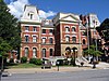
Marker title Image Date dedicated Location Marker type Topics Admiral Peary Park 1948 At site on SR 1005 just N of junction with SR 2014 W of Cresson Roadside Military, Military Post-Civil War, Professions & Vocations Allegheny Portage Railroad September 11, 1994 Intersection of Rts. 53 & 164, Portage Twp. Roadside Railroads, Transportation Cambria City September 1, 1994 418 Broad St., Johnstown 40°20′23″N 78°55′44″W / 40.3397°N 78.9288°W / 40.3397; -78.9288 (Cambria City ) City Cities & Towns, Coal, Ethnic & Immigration, Labor, Religion, Steel Cambria County May 25, 1982 County Courthouse, Center St., Ebensburg 40°31′33″N 78°43′30″W / 40.5257°N 78.7249°W / 40.5257; -78.7249 (Cambria County ) City Government & Politics, Government & Politics 19th Century Charles M. Schwab August 18, 1947 SR 1001 at Loretto 40°30′31″N 78°38′11″W / 40.50859°N 78.63629°W / 40.50859; -78.63629 (Charles M. Schwab ) Roadside Business & Industry, Education, Professions & Vocations, Steel Clara Barton (1821-1912) July 1, 1994 662 Main St., Johnstown City Medicine & Science, Professions & Vocations, Women Demetrius Gallitzin August 19, 1947 SR 1005 (former LR 276), Loretto 40°30′08″N 78°37′51″W / 40.5021°N 78.6309°W / 40.5021; -78.6309 (Demetrius Gallitzin ) Roadside Early Settlement, Ethnic & Immigration, Religion Dr. Lawrence F. Flick May 11, 1959 U.S. 219, 1 mile S of Carrolltown Roadside Medicine & Science, Professions & Vocations First Cambria AME Zion Church May 10, 1997 409 Haynes Street, Johnstown 40°19′12″N 78°55′17″W / 40.32°N 78.9213°W / 40.32; -78.9213 (First Cambria AME Zion Church ) City African American, Religion First Steel March 4, 1947 Pa. 56 in Johnstown, opposite steel mill (Missing) Roadside Business & Industry, Invention, Steel First Steel Rails August 18, 1947 Opposite steel mill (old Pa. 56), Johnstown Roadside Business & Industry, Iron, Railroads, Steel Hastings UMWA - District 2 Labor Chautauquas July 22, 2007 Brubaker Lane walking trail, Hastings (near Boro. Bldg. - 207 5th Ave.) Roadside Coal, Government & Politics 20th Century, Labor John Brophy November 6, 1993 Triangle Park, Route 271 40°19′12″N 78°50′13″W / 40.32°N 78.837°W / 40.32; -78.837 (John Brophy ) Roadside Coal, Government & Politics 20th Century, Labor Johnstown October 1, 1947 William Penn Ave. (ST 3037) at N city line (Missing) Roadside Business & Industry, Steel Johnstown Flood May 1975 North bound side of U.S. 219, at sta. 6/45, approx. one mile south of South Fork Boro. Roadside Environment Johnstown Flood May 31, 2005 Johnstown Festival Park - 90 Johns St., near the Stone Bridge City Environment Johnstown Flood August 18, 1947 Rager's Hill Rd. & Rt. 869, near Rt. 219, 1 mile S of South Fork 40°20′49″N 78°47′02″W / 40.34707°N 78.78386°W / 40.34707; -78.78386 (Johnstown Flood ) Roadside Environment Johnstown Local Flood Protection Project October 21, 1999 Point Park, Johnstown 40°19′49″N 78°55′29″W / 40.3302°N 78.9248°W / 40.3302; -78.9248 (Johnstown Local Flood Protection Project ) Roadside Environment, Government & Politics, Military Lemon House November 19, 1958 old U.S. 22 E of Cresson at county line Roadside Buildings, Business & Industry, Houses & Homesteads Loretto June 29, 1948 Manor Rd. (SR 1005), just outside Loretto 40°27′36″N 78°35′51″W / 40.46005°N 78.59758°W / 40.46005; -78.59758 (Loretto ) Roadside Education, Religion, Steel Loretto August 19, 1947 US 22 and PA 276 West of Cresson Roadside Business & Industry, Religion Malcolm Cowley August 20, 1994 U.S. 422, 2 miles W of Belsano 40°31′33″N 78°53′11″W / 40.5257°N 78.8864°W / 40.5257; -78.8864 (Malcolm Cowley ) Roadside Writers Portage Railroad August 19, 1947 Wm. Penn Hwy. (SR 2014 / old U.S. 22) at Portage Rd., just E of Cresson 40°27′27″N 78°34′22″W / 40.45747°N 78.57277°W / 40.45747; -78.57277 (Portage Railroad ) Roadside Railroads, Transportation Robert E. Peary August 19, 1947 Adm. Peary / Wm. Penn Hwy. (SR 2014 / old US 22) just W of Cresson 40°27′37″N 78°35′58″W / 40.46027°N 78.59933°W / 40.46027; -78.59933 (Robert E. Peary ) Roadside Exploration, Professions & Vocations Sgt. Michael Strank May 17, 1986 125 Main St. (Pa. 271), Franklin Borough 40°20′34″N 78°53′03″W / 40.3429°N 78.8843°W / 40.3429; -78.8843 (Sgt. Michael Strank ) Roadside Military, Military Post-Civil War Staple Bend Tunnel August 19, 1947 Pa. 271, 5 miles N of Johnstown (Missing) Roadside Railroads, Transportation