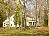
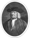
Marker title Image Date dedicated Location Marker type Topics Abraham L. Pennock October 24, 1985 At library on Maple Avenue between Wayne and Hazel, off S. State Rd. (SR 2026), Upper Darby 39°57′44″N 75°16′25″W / 39.9623°N 75.2736°W / 39.9623; -75.2736 (Abraham L. Pennock ) Roadside African American, Government & Politics, Government & Politics 19th Century, Underground Railroad, Women American Viscose Co. framless October 5, 2002 Viscose Village Plaza, Marcus Hook 39°49′18″N 75°24′44″W / 39.8217°N 75.4122°W / 39.8217; -75.4122 (American Viscose Co. ) Roadside Buildings, Business & Industry, Entrepreneurs, Labor, Military, Military Post-Civil War, Women Amos Bond House 2008 Located on the 11th fairway of Paxon Hollow Country Club, 850 Paxon Hollow Rd. Media, PA 19063
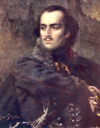
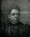
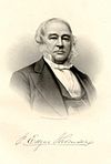
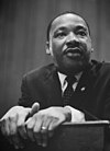
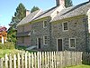
Roadside Early Settlement, Buildings, Houses - homesteads Anna Howard Shaw (1847-1919) May 17, 2014 S Orange St. & S Ridley Creek Rd., Media 39°54′21″N 75°23′48″W / 39.90596°N 75.39656°W / 39.90596; -75.39656 (Anna Howard Shaw ) Roadside Government & Politics 19th Century, Government & Politics 20th Century, Professions & Vocations, Religion, Science & Medicine, Women Battle of Brandywine May 12, 1952 US 1, at entrance to Brandywine Battlefield Park Roadside American Revolution, George Washington, Military Battle of Brandywine May 12, 1952 US 202/322 just S of Brinton's Bridge/Dilworthtown Rd., 1.6 miles N of US 1, Chadds Ford Roadside American Revolution, George Washington, Military Battle of Brandywine May 12, 1952 U.S. 1, at entrance to Brandywine Battlefield Park 39°49′22″N 75°35′18″W / 39.8227°N 75.5884°W / 39.8227; -75.5884 (Battle of Brandywine ) Roadside American Revolution, Military Benjamin West March 3, 1948 Pa. 320 in Swarthmore (Missing) Roadside Artists Caleb Pusey June 9, 1967 Race St. at City Rd., Upland 39°51′06″N 75°33′05″W / 39.8516°N 75.55145°W / 39.8516; -75.55145 (Caleb Pusey ) City Professions & Vocations, Religion, William Penn Casimir Pulaski September 13, 1975 U.S. 1 E of Chadds Ford near entrance to Brandywine Battlefield State Park 39°52′25″N 75°34′19″W / 39.8735°N 75.572°W / 39.8735; -75.572 (Casimir Pulaski ) Roadside American Revolution, Ethnic & Immigration, George Washington, Military Chester October 13, 1947 U.S. 322 at NW end of city Roadside Cities & Towns, Early Settlement, Ethnic & Immigration, Government & Politics, Government & Politics 17th Century, William Penn Colonial Courthouse May 14, 1954 Ave. of the States near 5th St., Chester 39°50′53″N 75°21′36″W / 39.848°N 75.3599°W / 39.848; -75.3599 (Colonial Courthouse ) City Buildings, Government & Politics, Government & Politics 18th Century Colonial Gristmill May 5, 1959 U.S. 1, 1 mile E of Concordville 39°53′28″N 75°30′20″W / 39.8911°N 75.5056°W / 39.8911; -75.5056 (Colonial Gristmill ) Roadside Buildings, Business & Industry, Ethnic & Immigration, Mills, Religion Darby Friends Burial Ground June 1952 Landsdowne Avenue near 12th Street, Darby Roadside Religion Delaware County October 3, 1982 Courthouse, Front St. & Veterans Sq., Media 39°55′09″N 75°23′31″W / 39.9192°N 75.392°W / 39.9192; -75.392 (Delaware County ) City Government & Politics, Government & Politics 18th Century, William Penn Dr. Anna E. Broomall March 26, 2019 Widener Univ., 13th & Chestnut Sts., Chester 39°51′35″N 75°21′22″W / 39.85972°N 75.35611°W / 39.85972; -75.35611 (Anna Broomall ) City Professions & Vocations, Science & Medicine, Women Dr. George Smith October 25, 1985 Off Marvine Ave. at Mansion Dr. on Collenbrook property, Drexel Hill 39°57′05″N 75°19′16″W / 39.9514°N 75.3211°W / 39.9514; -75.3211 (Dr. George Smith ) Roadside Education, Government & Politics, Government & Politics 19th Century, Medicine & Science, Professions & Vocations Dr. Philip Jaisohn May 21, 1994 100 E. Lincoln St., Media 39°54′50″N 75°23′16″W / 39.9139°N 75.3877°W / 39.9139; -75.3877 (Dr. Philip Jaisohn ) Roadside Ethnic & Immigration, Government & Politics, Government & Politics 20th Century, Medicine & Science, Professions & Vocations Eddystone Rifle Plant November 9, 2019 13th Ave. & Simpson St., Eddystone 39°51′52″N 75°20′35″W / 39.86436°N 75.34318°W / 39.86436; -75.34318 (Eddystone Rifle Plant ) Roadside Labor, Military, Military Post-Civil War, Women Fanny Jackson Coppin February 12, 1986 Cheyney University campus, off Dilworthtown & Cheyney Rds., Cheyney 39°55′58″N 75°31′40″W / 39.9327°N 75.5277°W / 39.9327; -75.5277 (Fanny M. Jackson Coppin ) City African American, Education, Professions & Vocations, Religion, Women, Writers FBI Office Burglary September 1, 2021 1-7 Veterans Square, Media, Pennsylvania 39°55′09″N 75°23′30″W / 39.91911°N 75.39175°W / 39.91911; -75.39175 (FBI Office Burglary ) Roadside Government & Politics, Government & Politics 20th Century Finland May 21, 1955 Concord Ave. at monument in Chester 39°50′59″N 75°22′41″W / 39.8496°N 75.378°W / 39.8496; -75.378 (Finland ) City Early Settlement, Ethnic & Immigration First Friends Meeting October 22, 1997 24th & Chestnut Sts., Chester 39°52′10″N 75°21′48″W / 39.8695°N 75.3632°W / 39.8695; -75.3632 (First Friends Meeting ) City Religion, William Penn Glen Mills September 23, 1997 Railroad Station, Glen Mills 39°55′13″N 75°29′25″W / 39.9204°N 75.4904°W / 39.9204; -75.4904 (Glen Mills ) Roadside Business & Industry, Government & Politics, Government & Politics 18th Century, Iron, Mills, Railroads Governor Printz Park June 28, 1948 At site, 2nd St. & Taylor Ave., Essington 39°51′44″N 75°18′09″W / 39.8623°N 75.3026°W / 39.8623; -75.3026 (Governor Printz Park ) Roadside Early Settlement, Ethnic & Immigration, Government & Politics 17th Century Great Trail (The) - Minquas or Susquehanna Indians (PLAQUE) June 5, 1926 Rose Valley Rd. (SR 3019), west side, 1/2 mile S of Moylan 39°53′55″N 75°23′15″W / 39.8985°N 75.3876°W / 39.8985; -75.3876 (Great Trail, The - Minquas or Susquehanna Indians -PLAQUE ) Plaque Early Settlement, Ethnic & Immigration, Native American, Paths & Trails Green-Bank May 15, 1954 2nd St. near Welsh St., Chester City Buildings, Houses & Homesteads, Military Haverford Meeting House September 24, 1946 U.S. 30 bypass near Haverford (Missing) City Houses & Homesteads, Religion Hilldale Athletic Club, The (The Darby Daisies) October 14, 2006 Cedar Ave. & MacDade Blvd., Yeadon 39°55′30″N 75°15′23″W / 39.9249°N 75.2565°W / 39.9249; -75.2565 (Hilldale Athletic Club, The "The Darby Daisies" ) Roadside African American, Baseball, Sports Ivy Mills September 4, 2001 109 Ivy Mill Road at Polecat Road, Glen Mills 39°53′08″N 75°29′06″W / 39.8856°N 75.4849°W / 39.8856; -75.4849 (Ivy Mills ) Roadside Business & Industry, Government & Politics 18th Century, Mills, Religion J. Edgar Thomson June 25, 1991 Junction SR 2016 (Baltimore Pike) & SR 2027 (Thomson Ave.) just NE of Swarthmore 39°54′57″N 75°20′15″W / 39.91577°N 75.33737°W / 39.91577; -75.33737 (J. Edgar Thomson ) City Professions & Vocations, Railroads, Transportation John Chadd's House September 1915 Lawn of Chadd homestead on PA 100 just N of US 1, Chadds Ford 39°52′29″N 75°35′30″W / 39.8748°N 75.5917°W / 39.8748; -75.5917 (John Chadd's House - PLAQUE ) Plaque American Revolution, Houses & Homesteads, Military John Morton January 27, 1967 420 E. Ridley Ave., Ridley Park, Chester 39°53′03″N 75°19′07″W / 39.8842°N 75.3185°W / 39.8842; -75.3185 (John Morton ) Roadside Government & Politics, Government & Politics 18th Century Joshua Humphrey October 13, 1947 SR 1001 (Haverford Ave.) near Haverford 39°59′49″N 75°18′12″W / 39.9969°N 75.3033°W / 39.9969; -75.3033 (Joshua Humphrey ) Roadside Military, Professions & Vocations Joshua Pusey March 27, 1993 #11 N. Middletown Rd. (Pa. 352), Lima 39°55′25″N 75°26′36″W / 39.9236°N 75.4434°W / 39.9236; -75.4434 (Joshua Pusey ) Roadside Business & Industry, Civil War, Invention, Professions & Vocations, Religion Lazaretto Quarantine Station October 25, 2008 99 Wanamaker Ave., at 2nd St. intersection, Essington 39°51′44″N 75°17′59″W / 39.8622°N 75.2996°W / 39.8622; -75.2996 (Lazaretto Quarantine Station ) Roadside Ethnic & Immigration, Government & Politics 19th Century, Medicine & Science Leiper Railway February 7, 1955 SR 2008 (Bullens Ln.) E of Pa. 320, Nether Providence Twp. 39°52′35″N 75°21′27″W / 39.8763°N 75.3576°W / 39.8763; -75.3576 (Leiper Railway ) Roadside Railroads, Transportation Lower Swedish Cabin October 21, 1989 At site on Creek Rd., Clifton Heights 39°56′17″N 75°18′05″W / 39.93818°N 75.30152°W / 39.93818; -75.30152 (Lower Swedish Cabin ) City Early Settlement, Ethnic & Immigration Marcus Hook October 13, 1947 U.S. 13 at Municipal Bldg., Marcus Hook 39°49′08″N 75°25′08″W / 39.819°N 75.4188°W / 39.819; -75.4188 (Marcus Hook ) Roadside Business & Industry, Early Settlement, Ethnic & Immigration Martin Luther King Jr. January 14, 1984 Calvary Baptist Church, 1616 W. 2nd St. (Pa. 291), Chester 39°50′14″N 75°22′41″W / 39.837250°N 75.377944°W / 39.837250; -75.377944 (Martin Luther King Jr. ) City African American, Civil Rights, Religion Martin Luther King Jr. July 27, 1992 Crozer-Chester Medical Center, One Medical Center Blvd., Upland 39°51′21″N 75°22′15″W / 39.8559°N 75.3709°W / 39.8559; -75.3709 (Martin Luther King Jr. ) City African American, Civil Rights, Religion Minquas' Path October 13, 1947 SR 3019 (Rose Valley Rd.) west side, 1/2 mile S of Moylan 39°53′55″N 75°23′15″W / 39.8985°N 75.3876°W / 39.8985; -75.3876 (Minquas' Path ) Roadside Native American, Paths & Trails, Transportation Morton Homestead September 9, 1966 At site, Pa. 420 at Darby Creek, Prospect Park 39°52′39″N 75°18′19″W / 39.8774°N 75.3053°W / 39.8774; -75.3053 (Morton Homestead ) Roadside Early Settlement, Government & Politics, Government & Politics 17th Century Morton Mortonson House March 6, 1955 Winona St. & Amosland Rd., Norwood (Missing) Roadside Buildings, Houses & Homesteads New Sweden April 9, 1988 Governor Printz Park, 2nd St. & Taylor Ave., Essington 39°51′40″N 75°18′10″W / 39.861°N 75.3027°W / 39.861; -75.3027 (New Sweden ) Roadside Early Settlement, Ethnic & Immigration, Exploration Nile Swim Club May 22, 2021 At entrance to club on 513 S Union Ave., Yeadon, Pennsylvania 39°56′03″N 75°15′50″W / 39.934095°N 75.263814°W / 39.934095; -75.263814 (Nile Swim Club ) Roadside African American, Civil Rights, Sports & Recreation Old Haverford Friends' Meeting October 24, 1975 SR 1005 (E. Eagle Rd.) at St. Denis Ave., Havertown 39°59′28″N 75°18′17″W / 39.991°N 75.3048°W / 39.991; -75.3048 (Old Haverford Friends' Meeting ) Roadside Religion, William Penn Old Swedish Burial Ground May 15, 1954 3rd St., E of Ave. of the States 39°50′50″N 75°21′30″W / 39.8472°N 75.3584°W / 39.8472; -75.3584 (Old Swedish Burial Ground ) City Ethnic & Immigration, Religion Penn Landing October 13, 1947 SE corner, 2nd (Pa. 291) & Penn Sts., Chester 39°50′39″N 75°21′41″W / 39.84413°N 75.36143°W / 39.84413; -75.36143 (Penn Landing ) Roadside Early Settlement, Exploration, Government & Politics, Government & Politics 17th Century, William Penn Pennsylvania May 12, 1949 U.S. 202 at state line 39°50′21″N 75°32′21″W / 39.8392°N 75.5393°W / 39.8392; -75.5393 (Pennsylvania ) Roadside Government & Politics, Government & Politics 17th Century, William Penn Pennsylvania May 12, 1949 U.S. 13 by-pass, approx. 100 feet from state line Roadside Government & Politics, Government & Politics 17th Century, William Penn Radnor Meeting House October 13, 1947 Junction Pa. 320 & SR SR 1019 (Conestoga Rd.), Ithan, S of St. Davids 40°01′49″N 75°21′50″W / 40.0303°N 75.364°W / 40.0303; -75.364 (Radnor Meeting House ) Roadside American Revolution, Early Settlement, Houses & Homesteads, Military, Religion Rochambeau Route (Narragansett Bay to Yorktown) October 18, 1954 U.S. 13 (Morton Ave.) near Melrose Ave., E end of Chester 39°51′31″N 75°21′09″W / 39.8585°N 75.3525°W / 39.8585; -75.3525 (Rochambeau Route (Narragansett Bay to Yorktown) ) Roadside American Revolution, Military, Roads, Transportation Sellers Hall October 25, 1985 N. side Walnut St. between Copley and Glendale Rds., Upper Darby 39°57′25″N 75°15′41″W / 39.9569°N 75.2615°W / 39.9569; -75.2615 (Sellers Hall ) Roadside Early Settlement, Buildings, Medicine & Science, Professions & Vocations The Slinky Toy August 30, 2019 2 W Baltimore Pike (at Springfield Rd.), Clifton Heights 39°55′44″N 75°17′49″W / 39.9289°N 75.2969°W / 39.9289; -75.2969 (Slinky Toy ) Roadside Invention, Sports & Recreation, Women Springfield Friends Meeting October 25, 1951 SR 2009 (Old Sproul & W. Springfield Rds.), Springfield 39°56′32″N 75°20′50″W / 39.9423°N 75.3471°W / 39.9423; -75.3471 (Springfield Friends Meeting ) Roadside Artists, Buildings, Education, Religion St. David's Church October 13, 1947 SR 1046 (St. David's Rd.) at SR 1017 (Church Rd.) 2 miles SW of Wayne 40°01′21″N 75°23′58″W / 40.0226°N 75.3994°W / 40.0226; -75.3994 (St. David's Church ) Roadside American Revolution, Ethnic & Immigration, Military, Religion Sun Shipbuilding and Dry Dock Company October 6, 2007 intersection of Industrial Hwy. (Rt. 291) & Harrahs Blvd., Chester Roadside Business & Industry, Labor, Military, Military Post-Civil War, Oil & Gas, Steel Tatiana Proskouriakoff (1909-1985) August 1, 2015 S Lansdowne Ave. & Fairview Ave., Lansdowne 39°56′00″N 75°16′12″W / 39.93326°N 75.27001°W / 39.93326; -75.27001 (Tatiana Proskouriakoff ) Roadside Education, Exploration, Professions & Vocations, Science & Medicine, Women, Writers Thomas Garrett October 25, 1981 Garrett Rd. & Maple Ave., Drexel Hill 39°56′46″N 75°17′37″W / 39.9461°N 75.2935°W / 39.9461; -75.2935 (Thomas Garrett ) Roadside African American, Religion, Underground Railroad Thomas Massey House May 9, 1986 467 Lawrence Rd. (SR 1020), .5 mile NE of Pa. 320, Broomall 39°57′57″N 75°21′06″W / 39.9658°N 75.3518°W / 39.9658; -75.3518 (Thomas Massey House ) Roadside Early Settlement, Buildings, Homesteads Tinicum October 13, 1947 Pa. 291 eastbound, just NE of Essington 39°52′02″N 75°17′37″W / 39.8671°N 75.2937°W / 39.8671; -75.2937 (Tinicum ) Roadside Early Settlement, Ethnic & Immigration, Government & Politics 17th Century Washington House May 15, 1954 Ave. of the States near 5th St., Chester 39°50′53″N 75°21′35″W / 39.8481°N 75.3596°W / 39.8481; -75.3596 (Washington House ) City American Revolution, Buildings, George Washington, Houses & Homesteads William Lightfoot Price November 6, 2021 At Thunderbird Lodge , 44 Rose Valley Rd., Rose Valley 39°53′55″N 75°23′15″W / 39.898625°N 75.387466°W / 39.898625; -75.387466 (William Lightfoot Price ) Roadside Buildings & Architecture William Penn (1644-1718) - "Essex House" - PLAQUE October 1932 102 Penn St., Chester Plaque Early Settlement, Houses & Homesteads, William Penn Williamson Free School of Mechanical Trades June 1, 2013 106 S New Middletown Rd, Media Roadside Buildings, Schools