Related Research Articles

Clayton is a city in and the seat of St. Louis County, Missouri. It borders the independent city of St. Louis. The population was 17,355 at the 2020 census. Organized in 1877, the city was named after Ralph Clayton, who donated the land for the St. Louis County courthouse.

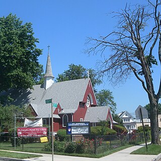
Jamaica is a neighborhood in the New York City borough of Queens. It is mainly composed of a large commercial and retail area, though part of the neighborhood is also residential. Jamaica is bordered by Hollis to the east; St. Albans, Springfield Gardens, Rochdale Village to the southeast; South Jamaica to the south; Richmond Hill and South Ozone Park to the west; Briarwood to the northwest; and Kew Gardens Hills, Jamaica Hills, and Jamaica Estates to the north.
Queens Village is a mostly residential middle class neighborhood in the eastern part of the New York City borough of Queens. It is bound by Hollis to the west, Cambria Heights to the south, Bellerose to the east, and Oakland Gardens to the north.

Atlantic Avenue is a major thoroughfare in the New York City boroughs of Brooklyn and Queens. It stretches from the Brooklyn waterfront on the East River all the way to Jamaica, Queens. Atlantic Avenue runs parallel to Fulton Street for much of its course through Brooklyn, where it serves as a border between the neighborhoods of Prospect Heights and Fort Greene and between Bedford-Stuyvesant and Crown Heights.
Springfield Gardens is a neighborhood in the southeastern area of the New York City borough of Queens, bounded to the north by St. Albans, to the east by Laurelton and Rosedale, to the south by John F. Kennedy International Airport, and to the west by Farmers Boulevard. The neighborhood is served by Queens Community Board 12. The area, particularly east of Springfield Boulevard, is sometimes also referred to as Brookville.

Normal Heights is a neighborhood of the mid-city region of San Diego, California.

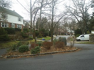
Jamaica Estates is a neighborhood in the New York City borough of Queens. Jamaica Estates is part of Queens Community District 8 and located in the northern portion of Jamaica. It is bounded by Union Turnpike to the north, Hillside Avenue to the south, Utopia Parkway and Homelawn Street to the west, and 188th Street to the east. The main road through the neighborhood is Midland Parkway.
Locust Manor is a neighborhood in the New York City borough of Queens. It is bordered on the north by Baisley Boulevard to Irwin Place to Roe Road to 120th Avenue, on the east by the tracks of the Long Island Rail Road to 121st Avenue to Farmers Boulevard, on the south by North Conduit Boulevard, and on the west by Guy R. Brewer Boulevard to 137th Avenue to 173rd Street to 134th Road to Bedell Street. Nearby neighborhoods include Jamaica, South Jamaica, and Rochdale Village. Locust Manor, which was named after a 1906 residential development in the area, was formerly the location of the Jamaica Race Course, which operated from 1903 to 1959, and was torn down in 1960 in order to construct Rochdale Village.

Union Turnpike is a thoroughfare stretching across part of Long Island in southern New York state, mostly within central and eastern Queens in New York City. It runs from Myrtle Avenue in Glendale, Queens, to Marcus Avenue in North New Hyde Park, Nassau County, about 1 mile (1.6 km) outside New York City border. The name memorializes the Union Racetrack, once a famous attraction for Queens residents.

U.S. Route 1 (US 1) is a major north–south U.S. Route, extending from Key West, Florida, in the south to Fort Kent, Maine, at the Canadian border in the north. In the U.S. state of Pennsylvania, US 1 runs for 81 miles (130 km) from the Maryland state line near Nottingham northeast to the New Jersey state line at the Delaware River in Morrisville, through the southeastern portion of the state. The route runs southwest to northeast and serves as a major arterial road through the city of Philadelphia and for many of the suburbs in the Delaware Valley metropolitan area. South of Philadelphia, the road mostly follows the alignment of the Baltimore Pike. Within Philadelphia, it mostly follows Roosevelt Boulevard. North of Philadelphia, US 1 parallels the route of the Lincoln Highway. Several portions of US 1 in Pennsylvania are freeway, including from near the Maryland state line to Kennett Square, the bypass of Media, the concurrency with Interstate 76 and the Roosevelt Expressway in Philadelphia, and between Bensalem Township and the New Jersey state line.

U.S. Route 13 is a U.S. highway running from Fayetteville, North Carolina, north to Morrisville, Pennsylvania. The route runs for 49.36 mi (79.44 km) through the Philadelphia metropolitan area in the U.S. state of Pennsylvania. The route enters the state from Delaware in Marcus Hook, Delaware County. It continues northeast through Delaware County, passing through the city of Chester before heading through suburban areas along Chester Pike to Darby. US 13 enters the city of Philadelphia on Baltimore Avenue and runs through West Philadelphia to University City, where it turns north along several city streets before heading east across the Schuylkill River along Girard Avenue. The route turns north and heads to North Philadelphia, where it runs northeast along Hunting Park Avenue. US 13 becomes concurrent with US 1 on Roosevelt Boulevard, continuing into Northeast Philadelphia. US 13 splits southeast on a one-way pair of streets before heading northeast out of the city on Frankford Avenue. The route continues into Bucks County as Bristol Pike, heading northeast to Bristol, where it turns into a divided highway. US 13 becomes a freeway in Tullytown and continues north to its terminus at US 1 in Falls Township, near Morrisville. US 13 roughly parallels Interstate 95 (I-95) through its course in Pennsylvania.

Broadway–Flushing is a historic district and residential subsection of Flushing, Queens, New York City. The neighborhood comprises approximately 2,300 homes. It is located between 155th and 170th Streets to the west and east respectively, and is bounded on the north by Bayside and 29th Avenues, and on the south by Northern Boulevard and Crocheron Avenue. Broadway–Flushing is listed on the National Register of Historic Places.

Sam Cooper Boulevard is an urban highway in Memphis, Tennessee, United States. The more recent western segment of the road follows a parkway design, while the older eastern portion, which was proposed and constructed as a segment of Interstate 40 (I-40), is built as a freeway, without at-grade intersections and traffic lights. The western terminus of Sam Cooper Boulevard is at East Parkway North. At the western termination point of the road there is a short concurrency of East Parkway North with U.S. Route 64 (US 64), US 70, and US 79. From its western end, Sam Cooper Boulevard continues east for 5.8 miles (9.3 km) to reach its eastern terminus at the I-40/I-240 interchange.
Conduit Avenue is an arterial road in New York City, the vast majority of which is in Queens. The divided highway runs from Atlantic Avenue in Cypress Hills, Brooklyn to Hook Creek Boulevard in Rosedale, Queens at the Nassau County border. The thoroughfare is named after an aqueduct in its right-of-way.
Bellaire was a station stop along the Hempstead Branch of the Long Island Rail Road. The station was located between 211th Street and 212th Street between 99th Avenue and Jamaica Avenue in Bellaire, Queens.
The community of Forest Park consists of almost 2900 private residential properties, plus apartments, condominiums, commercial properties, city-owned parks and schools, in approximately 1.4 square miles (3.6 km2) of the Northland area of northeast Columbus, Ohio. These properties adjoin a total of 132 distinct streets and courts maintained by the City of Columbus. The community's approximate center is near the intersection of Karl Road and Sandalwood Place in Columbus.
Shore Boulevard Mall is a waterfront promenade extending for nearly a mile along the southern bank of Sheepshead Bay in the Manhattan Beach neighborhood of Brooklyn, New York.
Foothill Malls is a series of eight traffic medians straddling 193rd Street between Foothill Avenue and Jamaica Avenue in the Hollis neighborhood of Queens, New York City.

Bellaire–Puritas is a neighborhood on the West Side of Cleveland, Ohio, in the United States. Originally part of the Village of West Park, it was annexed by the city in 1923. Formerly known as Puritas–Longmead, the neighborhood takes its name from the two streets which form its northern boundary: Puritas Avenue and Bellaire Road.
Holliswood is an affluent residential neighborhood located on the Harbor Hill Moraine in the east-central portion of the borough of Queens, New York City. Bounded to the north by the Grand Central Parkway, to the west by 188th street, the south by Hillside Avenue and to the east by Francis Lewis Boulevard.
References
- ↑ Belcher-Hyde Queens Atlas 1907
- ↑ "Interstate Park to be Cut Into Building Lots". Brooklyn Daily Eagle. August 18, 1906.
- ↑ Haller, Vera (May 29, 2013). "A Picket-Fence Experience". The New York Times.