
Mavelikkara is a taluk and municipality in the Onattukara region of Alappuzha district in the Indian state of Kerala. Located in the southern part of the district on the banks of the Achankovil River.
Kollam district, is one of 14 districts of the state of Kerala, India. The district has a cross-section of Kerala's natural attributes; it is endowed with a long coastline, a major Laccadive Sea seaport and an inland lake. The district has many water bodies. Kallada River is one among them, and the east side land of river is East Kallada and the west side land is West Kallada.
Kottarakkara, also transliterated as Kottarakara, is a town and municipality in the Kollam district of the Kerala, India. The town is close to Kollam Port, which has a rich history linked to the early medieval period as well as the reputation as an important commercial, industrial and trading center. Kottarakkara lies 27 kilometres (17 mi) to the east of Kollam city centre.
Punnala is a small village situated in Kollam district of Kerala, India. Punnala is located at a distance of 8 kilometers from both Pathanapuram and Punalur and 1 km from Chachipunna. It is in the Pathanapuram Taluk, Pathanapuram Assembly Constituency and Mavelikkara Parliament Constituency. Punnala is a part of Pathanapuram Block Panchayat and Kollam district Panchayat.

Pathanapuram is a Town in Pathanapuram Taluk Kollam district, Kerala, India. Pathanapuram is a part of Grama Panchayat and Block panchayat of same name and part of Kollam District Panchayat.
Elikkattoor is a village in India near Punalur, Kerala.

Pidavoor is a village in KOLLAM district in the state of Kerala, India. Pidavoor situated near the Pathanapuram town. Pidavoor is a part of Thalavoor Grama Panchayat. It is the eighth ward of Thalavoor panchayat. It is the border of Thalavoor and Pathanapuram Panchayat. The river Kalladayar divides these two panchayats.
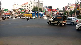
Valakom is a fastest growing town located on Kerala State highway One, in the Kollam district of Kerala, India, with population 17928. It lies within Kottarakkara municipal town, Ummannoor and edamulackal Panchayat.

Kottarakara railway station is a railway station in the Indian town of Kottarakkara in Kollam district, Kerala. Kottarakara railway station falls under the Madurai railway division of the Southern Railway zone of Indian Railways. It is a 'D-Class'(NSG 6) Adersh station. Indian railway is connecting Kottarakkara with various cities in India like Kollam, Thiruvananthapuram, Ernakulam, Thrissur, Palakkad, Kottayam, Madurai, Trichy, Chennai, Tenkasi, Tirunelveli, Nagercoil & with various towns like Punalur, Paravur, Kayamkulam, Thiruvalla, Changanacherry, Aluva, Guruvayoor, Punalur, Sengottai, Rajapalayam, Virudunagar, Mavelikkara, Chengannur, Aluva, Karunagappalli, Varkala, Kazhakkoottam, Neyyattinkara, Kanyakumari & Valliyur. Neighbourhood railway stations are Ezhukone and Kuri (Kura).
Kollam District has four types of administrative hierarchies:
Manchalloor is a village situated near Pathanapuram in Kollam District, Kerala state, India. Manchalloor is a part of Pathanapuram Grama panchayat, Block panchayat and Kollam district Panchayat.
Yeroor is a village situated near Anchal, Kollam district, Kerala, India.
Kundayam is a village situated near Pathanapuram in Kollam District, Kerala state, India. Kundayam is a part of Pathanapuram Block Panchayat and Kollam district Panchayat.
Panampatta is a place situated near Pathanapuram in Kollam District, Kerala state, India.
Panavely is a village situated near Kottarakkara in Kollam District, Kerala state, India.
Neduvannoor is a village situated near Pathanapuram in Kollam District in the Indian state of Kerala.
Nadutheri is a village near Thalavoor in Kollam District, Kerala state, India.
Parankimamukal is a village situated near Pathanapuram in Kollam District, Kerala state, India.
Pazhanjikadavu is a village situated near Pidavoor, Pathanapuram in Kollam District, Kerala state, India.
Padinjaretheruvu is one of the main village of the outskirts of Kottarakkara town, which is 0.5 kilometres (0.31 mi) west of Kizhekketheruvu on the National Highway 208, in Kollam District, Kerala state, India.


