Spencer, Oklahoma | |
---|---|
Coordinates: 35°30′28″N97°22′14″W / 35.50778°N 97.37056°W | |
Country | United States |
State | Oklahoma |
County | Oklahoma |
Area | |
• Total | 5.38 sq mi (13.94 km2) |
• Land | 5.38 sq mi (13.94 km2) |
• Water | 0.00 sq mi (0.00 km2) |
Elevation | 1,168 ft (356 m) |
Population (2020) | |
• Total | 3,978 |
• Density | 739.27/sq mi (285.42/km2) |
Time zone | UTC-6 (Central (CST)) |
• Summer (DST) | UTC-5 (CDT) |
ZIP code | 73084 |
Area code | 405 |
FIPS code | 40-69200 [3] |
GNIS feature ID | 2411952 [2] |
Website | www |
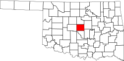
Spencer is a city in Oklahoma County, Oklahoma, United States, and a part of the Oklahoma City metropolitan area. The population was 3,978 at the 2020 census, a 1.7% increase from 2010.
Established in 1903, the City of Spencer is a historic community located just east of the North Canadian River. [4] Spencer is approximately ten miles from downtown Oklahoma City and borders the cities of Nicoma Park to the east and Midwest City to the south.
Contributing to the cultural fabric of Spencer are the Spencer Chamber of Commerce, the Facebook page-Whats going on in Spencer Oklahoma, Spencer Senior Center, Spencer Parks Board and the Spencer Historical Society. [4]
The region where Spencer was developed was opened to settlement in the Land Run of 1889. [5] Louis F. and Henry W. Kramer, businessmen originally from Spencer County, Indiana, first arrived in Guthrie in 1889 and then moved to Oklahoma City. [5]
Originally an agricultural area, Spencer grew after World War II with the nearby General Motors Assembly Plant and Tinker Air Force Base offering employment. [5]
On January 20, 1982, seven children were killed by the explosion of a water heater in the cafeteria of the city's Star Elementary School. [6] [7]
CPT Riley L. Pitts, the first black commissioned officer to receive the Medal of Honor, is buried in Spencer's Hillcrest Memory Gardens. Captain Pitts was a graduate of Wichita University (now Wichita State University.)
According to the United States Census Bureau, the city has a total area of 5.3 square miles (14 km2), all land.
Census | Pop. | Note | %± |
---|---|---|---|
1960 | 1,189 | — | |
1970 | 3,714 | 212.4% | |
1980 | 4,064 | 9.4% | |
1990 | 3,972 | −2.3% | |
2000 | 3,746 | −5.7% | |
2010 | 3,912 | 4.4% | |
2020 | 3,978 | 1.7% | |
U.S. Decennial Census [8] |
Race / Ethnicity (NH = Non-Hispanic) | Pop 2010 [9] | Pop 2020 [10] | % 2010 | % 2020 |
---|---|---|---|---|
White alone (NH) | 1,170 | 1,045 | 29.91% | 26.27% |
Black or African American alone (NH) | 2,191 | 2,029 | 56.01% | 51.01% |
Native American or Alaska Native alone (NH) | 113 | 114 | 2.89% | 2.87% |
Asian alone (NH) | 20 | 23 | 0.51% | 0.58% |
Pacific Islander alone (NH) | 1 | 5 | 0.03% | 0.13% |
Other race alone (NH) | 9 | 24 | 0.23% | 0.60% |
Mixed race or Multiracial (NH) | 242 | 295 | 6.19% | 7.42% |
Hispanic or Latino (any race) | 166 | 443 | 4.24% | 11.14% |
Total | 3,912 | 3,978 | 100.00% | 100.00% |
As of the census [3] of 2000, there were 3,746 people, 1,420 households, and 1,002 families residing in the city. The population density was 701.0 inhabitants per square mile (270.7/km2). There were 1,567 housing units at an average density of 293.3 per square mile (113.2/km2). The racial makeup of the city was 39.94% White, 51.82% African American, 2.83% Native American, 0.35% Asian, 0.05% Pacific Islander, 0.51% from other races, and 4.51% from two or more races. Hispanic or Latino of any race were 2.32% of the population.
There were 1,420 households, out of which 29.4% had children under the age of 18 living with them, 47.0% were married couples living together, 17.8% had a female householder with no husband present, and 29.4% were non-families. 26.1% of all households were made up of individuals, and 11.5% had someone living alone who was 65 years of age or older. The average household size was 2.59 and the average family size was 3.09.
In the city, the population was spread out, with 28.8% under the age of 18, 7.8% from 18 to 24, 24.2% from 25 to 44, 24.1% from 45 to 64, and 15.1% who were 65 years of age or older. The median age was 38 years. For every 100 females, there were 94.6 males. For every 100 females age 18 and over, there were 88.4 males.
The median income for a household in the city was $31,116, and the median income for a family was $37,470. Males had a median income of $30,199 versus $21,153 for females. The per capita income for the city was $18,242. About 15.0% of families and 19.1% of the population were below the poverty line, including 33.3% of those under age 18 and 11.2% of those age 65 or over.
It is in Oklahoma City Public Schools. [11] Zoned schools include Willow Brook Elementary School (PreKindergarten-Grade 1), Spencer Elementary School (grades 2-4), and Rogers Intermediate School (grades 5-6). [12] The zoned secondary school is Star Spencer Mid-High School. [13] [14]
Dundjee School was all-Black school that was built in 1934 and opened as a segregated school in 1935 serving black students in Spencer. [15] The school is named after Black Oklahoma City civil rights leader Roscoe Dunjee. The school served 1st through 12th-grade students and according to Dr. Donnie Nero the school was nurturing, and enriching, but also tough. “Those teachers those educators made sure that we focused on being the best that we possibly could be so there wasn't a lot of time for foolishness or time to waste,” said Nero. [16] The school featured some of the best and brightest black teachers, such as civil rights leader Clara Luper, and the Rev. W.B. Parker, pastor of nearby St. James Baptist Church. [17] Dunjee school closed in 1972, devastating the community of Spencer.
The residents of the Dunjee area had long suffered at the hand of segregation in Oklahoma. Before 1963 it was part of the Choctaw school system. After years of substandard support from the City of Choctaw, they fought to be integrated into the Oklahoma City school system and won. However, in 1972 the school board closed all Dunjee schools and began bussing as part of the mandated laws of de-segregation. The community was stunned. [18]
Because of de-segregation Dunjee closed its doors in 1972, a move that in many eyes damaged the Spencer community. When the school's doors shut for good, "it devastated this community," said Theotis Payne. [17] In 2012 a fire causing $250,000 in damage made the school uninhabitable. [16]
In 2013, the City of Spencer came under fire after several officials affiliated with the city were accused of embezzling funds; this was perpetrated by three previous employees of the city. An estimated $6,200 in funds were missing from the payroll system, and the three employees were shortly charged with embezzlement [19]
Franklin County is a county located in the U.S. state of Alabama. As of the 2020 census, the population was 32,113. Its county seat is Russellville. Its name is in honor of Benjamin Franklin, famous statesman, scientist, and printer. It is a dry county, although the city of Russellville is wet.
Winston County is a county located in the U.S. state of Mississippi. In the 2020 census, the population was 17,714. Its county seat is Louisville. The county is named for Louis Winston (1784–1824), a colonel in the militia, a prominent lawyer, and a judge of the Mississippi Supreme Court.
Lake View is a city in Phillips County, Arkansas, United States. The population was 443 at the 2010 census. Because there is also a Lakeview in Baxter County. The original settlement name was "Turkey Scratch" from the 1850s to the official declaration of the town's namesake was in the 1920s. When the town was re-established in 1937, Lake View became one of three communities in Arkansas to be reserved for black farm families by the Resettlement Administration. It is one of the few communities in the U.S. with an African-American percentage at over 90 percent of the populations.
Cooper City is a city in Broward County, Florida, United States. The city is named for Morris Cooper, who founded the community in 1959. It's part of the Miami metropolitan area of South Florida. The city's population was 34,401 at the 2020 census.
Choctaw is a city in Oklahoma County, Oklahoma, United States, with a population of 12,182 at the 2020 census, a 9.3% increase from 2010. It is the oldest chartered town in Oklahoma Territory. The city is located approximately 10 miles (16.1 km) east of Oklahoma City and is part of the Oklahoma City metropolitan area.
Forest Park is a town in Oklahoma County, Oklahoma, United States, and a part of the Oklahoma City metropolitan area. The population was 998 at the 2010 census.
Midwest City is a city in Oklahoma County, Oklahoma, United States, and a part of the Oklahoma City metropolitan area. As of the 2020 census, the population was 58,409, making it the eighth largest city in the state.
Nichols Hills is a city in Oklahoma County, Oklahoma, United States, and a part of the Oklahoma City metropolitan area. The population was 3,870 as of the 2020 census, a 4.3% increase from 2010.
Nicoma Park is a city in Oklahoma County, Oklahoma, United States, and a part of the Oklahoma City metropolitan area. The name Nicoma is a portmanteau of the first three letters of Nichols, for G.A. Nichols, and the last three letters of Oklahoma. The population was 2,313 at the 2020 census, a 3.3% decrease from 2010.
The Village is a city in Oklahoma County, Oklahoma, United States, and a part of the Oklahoma City metropolitan area. The population was 9,538 at the 2020 Census.
Escobares is a city in Starr County, Texas, United States. The population was 2,588 at the 2020 census. The city was formed in 2005 from part of the deleted Escobares CDP, and parts of Garceno, and North Escobares CDPs, and additional area. Prior to its 2005 incorporation as a city, it was a census-designated place (CDP). The population of the CDP was 1,954 at the 2000 census.
Falcon Heights is a census-designated place (CDP) in Starr County, Texas, United States. The population was 18 at the 2020 census, down from 53 at the 2010 census.
Falcon Village is a census-designated place (CDP) in Starr County, Texas, United States. The population was 3 at the 2020 census.
Fronton is a census-designated place (CDP) in Starr County, Texas, United States, bordering the Mexican state of Tamaulipas, close to Ciudad Miguel Alemán. The population was 172 at the 2020 census, a decline from the figure of 180 tabulated in 2010.
Garceno is a census-designated place (CDP) in Starr County, Texas, United States. The population was 440 at the 2020 census, an increase from the figure of 420 tabulated in 2010.
La Rosita is a census-designated place (CDP) in Starr County, Texas, United States. The population was 85 at the 2010 census, a decline from the figure of 1,729 tabulated in 2000 due to the Census Bureau redefining the CDP. By the 2020 census, the population further decreased to 82.
Los Alvarez is a census-designated place (CDP) in Starr County, Texas, United States. The population was 303 at the 2010 census, a decline from the figure of 1,434 tabulated in 2000.
North Escobares is a census-designated place (CDP) in Starr County, Texas, United States. The population was 162 at the 2020 census.
Roma Creek is a former census-designated place (CDP) in Starr County, Texas, United States. The population was 350 at the 2010 census down from 610 at the 2000 census.
Salineño is a census-designated place (CDP) in Starr County, Texas, United States. The name was changed in 2008, adding a tilde over the second n. The population was 176 at the 2020 census, down from 201 at the 2010 census.