Related Research Articles

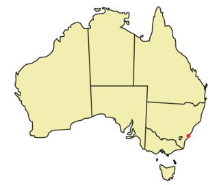
Wollongong is a city located in the Illawarra region of New South Wales, Australia. The name is believed to originate from the Dharawal language, meaning either 'five islands/clouds', 'ground near water' or 'sound of the sea'. Wollongong lies on the narrow coastal strip between the Illawarra Escarpment and the Pacific Ocean, 85 kilometres south of central Sydney. Wollongong had an estimated urban population of 302,739 at June 2018, making it the third-largest city in New South Wales after Sydney and Newcastle and the tenth-largest city in Australia by population. The city's current Lord Mayor is Tania Brown who was elected in 2024.

The Illawarra is a coastal region in the southeast of the Australian state of New South Wales. It is situated immediately south of Sydney and north of the South Coast region. It encompasses the two cities of Wollongong, Shellharbour and the coastal town of Kiama. Wollongong is the largest city of the Illawarra with a population of 240,000, then Shellharbour with a population of 70,000 and Kiama with a population of 10,000. These three cities have their own suburbs. Wollongong stretches from Otford in the north to Windang in the south, with Maddens Plains and Cordeaux in the west.
Spring Hill may refer to:
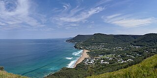
Stanwell Park is a coastal village and northern suburb of Wollongong, New South Wales, Australia. It is the northernmost point of the Illawarra coastal strip and lies south of Sydney's Royal National Park. It is situated in a small valley between Bald Hill to the north, Stanwell Tops to the west and Mount Mitchell to the south. It has two lagoons from the village's two creeks, Stanwell and Hargrave Creeks, and a beach running between headlands. Stanwell Park and the surrounding suburbs are colloquially referred to by its postcode 2508.
The IG postcode area, also known as the Ilford postcode area, is a group of eleven postcode districts in England, within six post towns. These cover parts of eastern Greater London and south-west Essex.
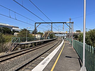
Lysaghts railway station is an intercity train station located in Spring Hill, New South Wales, Australia, on the South Coast railway line's Port Kembla branch. The station serves NSW TrainLink trains travelling south to Port Kembla and north to Wollongong and Sydney. The station is surrounded on both sides by the Lysaght factory at Spring Hill. Trains only stop on request. There is no way out of the station unless commuters work at the neighbouring steelworks.
Wollongong is an electoral district of the Legislative Assembly in the Australian state of New South Wales. It is represented by Paul Scully of the Labor Party. Since a redistribution in 2013, it has covered an area of 79.25 square kilometres and includes the localities of Berkeley, Coachwood Park, Coniston, Cordeaux Heights, Corrimal, Cringila, Fairy Meadow, Farmborough Chase, Farmborough Heights, Figtree, Gwynneville, Kembla Grange, Kembla Heights, Kemblawarra, Lake Heights, Lindsay Heights, Mangerton, Mount Kembla, Mount Saint Thomas, North Wollongong, Port Kembla, Primbee, Spring Hill, Towradgi, Unanderra, Warrawong, West Wollongong, Windang, Wollongong.

North Wollongong is a coastal suburb of the City of Wollongong, New South Wales, Australia. It is immediately to the north of the Wollongong city centre. Although North Wollongong is an official suburb with precise boundaries, the term North Wollongong may refer to northern areas of Wollongong which are not part of the suburb.
The DY postcode area, also known as the Dudley postcode area, is a group of fourteen postcode districts in England, within eight post towns. These cover the south-western part of the West Midlands and north Worcestershire, plus the south-westernmost part of Staffordshire and a small part of south-east Shropshire.

Bombo is a suburb of the Municipality of Kiama, in the Illawarra region of New South Wales, Australia. It is located 2 kilometres (1.2 mi) north of Kiama.
The RH postcode area, also known as the Redhill postcode area, is a group of twenty postcode districts in South East England, within seventeen post towns. These cover east Surrey and northeastern West Sussex plus small parts of northwestern East Sussex.
The DH postcode area, also known as the Durham postcode area, is a group of nine postcode districts in north-east England, within five post towns. These cover northern County Durham, parts of southern Tyne and Wear and a small part of southern Northumberland.
The TN postcode area, also known as the Tunbridge Wells postcode area, is a group of 40 postcode districts in England, within 24 post towns. These cover south and west Kent and northern and eastern East Sussex, plus very small parts of Surrey and the London Borough of Bromley.
Mangerton is an inner western suburb of the coastal city of Wollongong, New South Wales, Australia.
The city of Wollongong has a distinct geography. It lies on a narrow coastal plain flanked by the Pacific Ocean to the east and a steep sandstone precipice known as the Illawarra Escarpment to the west, most notably Mount Keira, joined to the escarpment by a high saddle.
Smiths Hill Fort was a fort at North Wollongong, New South Wales, Australia. The fort was also known as Wollongong Fort.
Berkeley is a suburb of Wollongong, New South Wales. The suburb is located in Wollongong's southern suburbs, on the northern shore of Lake Illawarra, and is one of the city's most populous suburbs. At the 2021 census, it had a population of 7,798.

The Wollongong Head Lighthouse, also known as Flagstaff Hill Lighthouse or Flagstaff Point Light, is an active lighthouse located adjacent to the heritage-listed Wollongong Harbour precinct in Wollongong, a coastal city south of Sydney, New South Wales, Australia. It overlooks the Tasman Sea from the top of Flagstaff Point, directly east of the city centre. Wollongong is the only place in the east of Australia to have two lighthouses located in close proximity of each other, the other being Wollongong Breakwater Lighthouse.

Dion's Bus Service is an Australian bus company operating services in Wollongong.
References
- ↑ "Spring Hill, Wollongong Postcode" . Retrieved 13 June 2022.
| | This Wollongong geography article is a stub. You can help Wikipedia by expanding it. |