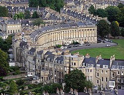
The following is a timeline of the history of the city of Bath, Somerset, England.
History of England |
---|
![]() |
![]() |
Bath is a city in the Bath and North East Somerset unitary area in the ceremonial county of Somerset, England, known for and named after its Roman-built baths. At the 2021 Census, the population was 101,557. Bath is in the valley of the River Avon, 97 miles (156 km) west of London and 11 miles (18 km) southeast of Bristol. The city became a World Heritage Site in 1987, and was later added to the transnational World Heritage Site known as the "Great Spa Towns of Europe" in 2021. Bath is also the largest city and settlement in Somerset.
Aquae Sulis was a small town in the Roman province of Britannia. Today it is the English city of Bath, Somerset. The Antonine Itinerary register of Roman roads lists the town as Aquis Sulis. Ptolemy records the town as Aquae calidae in his 2nd-century work Geographia.
Bath and North East Somerset (B&NES) is a unitary authority district in England. Bath and North East Somerset Council was created on 1 April 1996 following the abolition of the county of Avon. It is part of the ceremonial county of Somerset.
The Roman Baths are well-preserved thermae in the city of Bath, Somerset, England. A temple was constructed on the site between 60 and 70 AD in the first few decades of Roman Britain. Its presence led to the development of the small Roman urban settlement known as Aquae Sulis around the site. The Roman baths—designed for public bathing—were used until the end of Roman rule in Britain in the 5th century AD. According to the Anglo-Saxon Chronicle, the original Roman baths were in ruins a century later. The area around the natural springs was redeveloped several times during the Early and Late Middle Ages.
John Wood, the Elder was an English architect, working mainly in Bath.
Henry Edmund Goodridge was an English architect based in Bath. He worked from the early 1820s until the 1850s, using Classical, Italianate and Gothic styles.
Weston is a suburb and electoral ward of Bath in Bath and North East Somerset, South West England, located in the northwest of the city. Originally a separate village, Weston has become part of Bath as the city has grown, first through the development of Lower Weston in Victorian times and then by the incorporation of the village into the city, with the siting of much local authority housing there in the period after World War II.
Beckford's Tower, originally known as Lansdown Tower, is an architectural folly built in neo-classical style on Lansdown Hill, just outside Bath, Somerset, England. The tower and its attached railings are designated as a Grade I listed building. Along with the adjoining Lansdown Cemetery it is Grade II listed on the Register of Historic Parks and Gardens of special historic interest in England.
Newbridge is a largely residential electoral ward on the western edge of Bath, England.
John Palmer was an English architect who worked on some of the notable buildings in the city of Bath, Somerset, UK. He succeeded Thomas Baldwin as City Architect in 1792. He died in Bath.
Walcot is a suburb of the city of Bath, England. It lies to the north-north-east of the city centre, and is an electoral ward of the city.
The City of Bath Technical School in Bath, Somerset, England had various roles from the late 19th century until 1970. It obtained its official name when technical schools were formally introduced in Bath between the years 1892 and 1896, and at first was housed in a new extension of the Guildhall. The school was transformed in the early 20th century, when it was combined with several other institutions, and then evolved through various sites and roles until its closure at Brougham Hayes, Lower Oldfield Park in 1973 after being renamed in 1971 as Culverhay School.
Cleveland Pools located in Hampton Row, Bath, Somerset, England is a semi-circular lido built to designs by John Pinch the Elder in 1815. It is believed to be the oldest public outdoor swimming pool in the UK. It is a Grade II* listed building.
The buildings and architecture of Bath, a city in Somerset in the south west of England, reveal significant examples of the architecture of England, from the Roman Baths, to the present day. The city became a World Heritage Site in 1987, largely because of its architectural history and the way in which the city landscape draws together public and private buildings and spaces. The many examples of Palladian architecture are purposefully integrated with the urban spaces to provide "picturesque aestheticism". In 2021, the city was added to a second World Heritage Site, a group of historic spa towns across Europe known as the "Great Spas of Europe". Bath is the only entire city in Britain to achieve World Heritage status, and is a popular tourist destination.
The Anglican Bath Abbey Cemetery, officially dedicated as the Cemetery of St Peter and St Paul, was laid out by noted cemetery designer and landscape architect John Claudius Loudon (1783–1843) between 1843 and 1844 on a picturesque hillside site overlooking Bath, Somerset, England.
The Midland Bridge is a road bridge over the River Avon in Bath, Somerset, England, now carrying the B3118 road. It was originally built in 1870 by the Midland Railway Company to allow access to and from their goods station at Sydenham Field on the south bank of the river Avon, the opposite bank to the passenger Green Park terminus station and the city centre.
Kingsmead is an electoral ward within Bath, England, which encompasses most of Bath city centre and stretches west along the A4 to meet Newbridge and Weston wards. The ward elects two councillors to the Bath and North East Somerset unitary authority.
Abbey was an electoral ward covering the centre of Bath, England. It was abolished as part of the boundary changes effected at the elections held on 2 May 2019.
The following is a timeline of the history of the city of Bristol, England.
Bath and North East Somerset is a unitary authority created on 1 April 1996, following the abolition of the County of Avon, which had existed since 1974. Part of the ceremonial county of Somerset, Bath and North East Somerset occupies an area of 220 square miles (570 km2), two-thirds of which is green belt. It stretches from the outskirts of Bristol, south into the Mendip Hills and east to the southern Cotswold Hills and Wiltshire border. The city of Bath is the principal settlement in the district, but BANES also covers Keynsham, Midsomer Norton, Radstock and the Chew Valley. The area has a population of 170,000, about half of whom live in Bath, making it 12 times more densely populated than the rest of the area.
{{cite book}}
: |work=
ignored (help){{cite book}}
: CS1 maint: location missing publisher (link){{cite book}}
: External link in |editor=
(help)CS1 maint: location missing publisher (link){{cite book}}
: CS1 maint: multiple names: authors list (link){{cite book}}
: CS1 maint: multiple names: authors list (link)