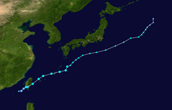
Timeline of the 2018 Pacific typhoon season | |
---|---|
Season boundaries | |
First system formed | December 29, 2017 |
Last system dissipated | January 8, 2019 |
Strongest system | |
Name | Kong-rey & Yutu |
Maximum winds | 215 km/h (130 mph) (10-minute sustained) |
Lowest pressure | 900 hPa (mbar) |
Longest lasting system | |
Name | Typhoon Yutu |
Duration | 13.25 days |
The 2018 Pacific typhoon season was formerly the costliest Pacific typhoon season on record before being surpassed the following year. The season had no official boundaries, and storms can form year-round, as evidenced by the formation of Tropical Storm Bolaven in late December 2017, and Tropical Storm Pabuk on December 31, 2018. Despite this, activity usually peaks between May and November. The season featured above-average activity, with 29 named storms, 13 typhoons, and 7 super typhoons forming in the West Pacific. [1] [2] [nb 1]
The Japan Meteorological Agency (JMA) is the official Regional Specialized Meteorological Centre for the Western Pacific Basin. As such, it is responsible for assigning names to all tropical cyclones that reach 10-minute maximum sustained winds of at least 65 kilometres per hour (40 mph) in the region. [4] The PAGASA assigns names to tropical cyclones that form or enter their area of responsibility as a tropical depression or stronger, regardless if the cyclone has been assigned a name by the JMA. [5] The Joint Typhoon Warning Center (JTWC) also monitors systems in the Western Pacific Basin, assigning systems a number with a "W" suffix if the system is a tropical depression or stronger.
January 1
January 2
January 3
January 4
February 8
February 10
February 11
February 13
February 14
February 15
February 16
March 24
March 25
March 27
March 28
March 29
March 30
March 31
April 1
May 10
May 12
May 13
May 14
May 15
June 2
June 3
June 4
June 5
June 6
June 7
June 8
June 9
June 10
June 11
June 13
June 14
June 15
June 16
June 17
June 18
June 21
June 28
June 29
July 1
July 2
July 3
July 4
July 5
July 6
July 8
July 9
July 10
July 11
July 13
July 14
July 15
July 16
11W made 3 landfalls on Camiguin de Babuyanes, Fuga Island, and Dalupiri Island. [32]
July 17
July 18
Son-Tinh made a fifth landfall on Hà Tĩnh Province. [37]
July 19
July 20
July 21
July 22
Son-Tinh made a sixth landfall on Hainan. [7]
July 23
Son-Tinh made a seventh and eighth landfall on the Leizhou Peninsula. [7]
July 24
July 25
July 26
July 27
July 28
July 29
July 30
July 31
August 1
August 2
August 3
August 4
August 5
August 6
August 7
August 8
August 9
August 10
August 11
August 12
August 13
August 14
August 15
August 16
August 17
August 18
August 19
August 20
August 21
August 22
August 23
August 24
August 25
August 26
August 27
August 28
August 29
August 30
August 31
September 1
September 2
September 3
September 4
September 5
September 6
September 7
September 8
September 9
September 10
September 11
September 12
September 13
September 14
September 15
September 16
September 17
September 18
September 20
September 21
September 22
September 23
September 24
September 25
September 26
September 27
September 28
September 29
September 30
October 1
October 2
October 3
October 4
October 5
October 6
October 7
October 19
October 20
October 21
October 22
October 23
October 24
October 25
October 26
October 27
October 28
October 29
October 30
October 31
November 2
November 3
November 13
November 16
November 17
November 18
November 20
November 21
November 22
November 23
November 24
November 25
November 26
November 27
November 28
November 30
December 25
December 27
December 28
December 29
December 31
The 2001 Pacific typhoon season was an average season with twenty-six named storms, sixteen typhoons and three super typhoons, with a near normal Accumulated Cyclone Energy (ACE) of 307.3 units. It ran year-round in 2001, with most tropical cyclones in the northwestern Pacific Ocean tending between May and November.
This timeline documents all of the events of the 2005 Pacific typhoon season, the period that tropical cyclones formed in the Western Pacific Ocean during the year. The scope of this article is limited to the Pacific Ocean, north of the equator between 100°E and the International Date Line. Tropical depressions that form in the basin were given a number with a "W" suffix by the United States' Joint Typhoon Warning Center (JTWC). If a depression intensified into a tropical storm, it would be assigned a name by the Japan Meteorological Agency (JMA). In addition, the Philippine Atmospheric, Geophysical and Astronomical Services Administration (PAGASA) assigned names to tropical cyclones which were in their area of responsibility.
The 1988 Pacific typhoon season was a very active season in terms of named storms, though it only featured 11 typhoons and 1 super typhoon. It had no official bounds; it ran year-round in 1988, but most tropical cyclones formed between May and November. Tropical storms that formed in the entire west Pacific basin were assigned a name by the Joint Typhoon Warning Center. Tropical depressions that enter or form in the Philippine area of responsibility are assigned a name by the Philippine Atmospheric, Geophysical and Astronomical Services Administration or PAGASA. This can often result in the same storm having two names.
This timeline documents all events that have taken place during the 2007 Pacific typhoon season. This article is limited to the Western Pacific basin which is located north of the equator and between 100°E and the International Date Line. Systems that reach tropical storm intensity are assigned a name by the Japan Meteorological Agency (JMA). Tropical depressions that form within the basin are assigned a number with a "W" suffix by the Joint Typhoon Warning Center (JTWC). Additionally, the Philippine Atmospheric, Geophysical and Astronomical Services Administration (PAGASA) assigns names to tropical cyclones that either form in or move into its self defined area of responsibility, which runs from 135°E to 115°E and 5°N to 25°N.
This timeline documents all of the events of the 2009 Pacific typhoon season which was the period that tropical cyclones formed in the Western Pacific Ocean during 2009, with most of the tropical cyclones forming between May and November. The scope of this article is limited to the Pacific Ocean, north of the equator between 100°E and the International Date Line. Tropical storms that form in the entire Western Pacific basin are assigned a name by the Japan Meteorological Agency. Tropical depressions that form in this basin are given a number with a "W" suffix by the United States' Joint Typhoon Warning Center. In addition, the Philippine Atmospheric, Geophysical and Astronomical Services Administration (PAGASA) assigns names to tropical cyclones that enter or form in the Philippine area of responsibility. These names, however, are not in common use outside of the Philippines.
The 2018 Pacific typhoon season was at the time, the costliest Pacific typhoon season on record, until the record was beaten by the following year. The season was well above-average, producing twenty-nine storms, thirteen typhoons, seven super typhoons and six Category 5 tropical cyclones. The season ran throughout 2018, though most tropical cyclones typically develop between May and October. The season's first named storm, Bolaven, developed on January 3, while the season's last named storm, Man-yi, dissipated on November 28. The season's first typhoon, Jelawat, reached typhoon status on March 29, and became the first super typhoon of the year on the next day.
This timeline documents all of the events of the 2010 Pacific typhoon season. Most of the tropical cyclones forming between May and November. The scope of this article is limited to the Pacific Ocean, north of the equator between 100°E and the International Date Line. Tropical storms that form in the entire Western Pacific basin are assigned a name by the Japan Meteorological Agency. Tropical depressions that form in this basin are given a number with a "W" suffix by the United States' Joint Typhoon Warning Center. In addition, the Philippine Atmospheric, Geophysical and Astronomical Services Administration (PAGASA) assigns names to tropical cyclones that enter or form in the Philippine area of responsibility. These names, however, are not in common use outside of the Philippines.
The 2020 Pacific typhoon season was the first of an ongoing series of below average Pacific typhoon seasons, and became the first with below-average tropical cyclone activity since 2014, with 23 named storms, 10 of which became typhoons and only 2 became super typhoons. This low activity was a consequence of La Niña that persisted from the summer of the year. It had the sixth-latest start in the basin on record, slightly behind 1973, and was the first to start that late since 2016. The first half of the season was unusually inactive, with only four systems, two named storms and one typhoon at the end of July. Additionally, the JTWC recorded no tropical cyclone development in the month of July, the first such occurrence since reliable records began. Despite that, this season featured Super Typhoon Goni, which made the strongest landfall worldwide in terms of 1-minute wind speed. The season's first named tropical cyclone, Vongfong, developed on May 8, while the season's last named tropical cyclone, Krovanh, dissipated on December 24. However, the season's last system was an unnamed tropical depression which dissipated on December 29.
Most of the tropical cyclones of the 2013 Pacific typhoon season formed between May and November of that year. The scope of this article is the Pacific Ocean north of the equator, between 100°E and the International Date Line. Tropical storms which form in the Western Pacific basin are assigned a name by the Japan Meteorological Agency (JMA). Tropical depressions forming in this basin are given a number with a "W" suffix by the United States' Joint Typhoon Warning Center (JTWC). The Philippine Atmospheric, Geophysical and Astronomical Services Administration (PAGASA) assigns names to tropical cyclones that enter or form in the Philippine area of responsibility, but these names are not in common use outside the Philippines.
This timeline documents all of the events of the 2014 Pacific typhoon season. Most of the tropical cyclones forming between May and November. The scope of this article is limited to the Pacific Ocean, north of the equator between 100°E and the International Date Line. Tropical storms that form in the entire Western Pacific basin are assigned a name by the Japan Meteorological Agency. Tropical depressions that form in this basin are given a number with a "W" suffix by the United States' Joint Typhoon Warning Center. In addition, the Philippine Atmospheric, Geophysical and Astronomical Services Administration (PAGASA) assigns names to tropical cyclones that enter or form in the Philippine area of responsibility. These names, however, are not in common use outside of the Philippines.
Typhoon Lingling, known in the Philippines as Typhoon Nanang, was a deadly typhoon that struck the Philippines and Vietnam in 2001 and caused 379 deaths. The name "Lingling" was given by Hong Kong. The 39th tropical depression, 22nd named storm, and 13th typhoon of the 2001 Pacific typhoon season, Lingling developed into a tropical depression on November 6 and given the local name Nanang by the PAGASA. The next day, it was upgraded into a tropical storm and given the name Lingling by the Japan Meteorological Agency (JMA). Lingling's intensity briefly stagnated as it moved over Visayas before resuming intensification and intensifying into a severe tropical storm on November 8. One day later, both the JMA and the Joint Typhoon Warning Center (JTWC) upgraded Lingling to a typhoon as it exited the Philippine archipelago and moved into the South China Sea. After intensifying into a typhoon, Lingling began to quickly intensify, peaking with 10-min sustained winds of 155 km/h (96 mph) and 1-min sustained winds of 215 km/h (134 mph), with a minimum central pressure of 940 mbar (28 inHg). Lingling began to weaken as it approached the Vietnamese coast, before making landfall on November 11 at 18:00 UTC. Lingling rapidly weakened afterward, dissipating on November 12.
Typhoon Hagupit known in the Philippines as Super Typhoon Ruby, was the second most intense tropical cyclone in 2014. Hagupit particularly impacted the Philippines in early December while gradually weakening, killing 18 people and causing $114 million of damage in the country. Prior to making landfall, Hagupit was considered the worst threat to the Philippines in 2014, but it was significantly smaller than 2013's Typhoon Haiyan.
This timeline documents all of the events of the 2015 Pacific typhoon season. Most of the tropical cyclones formed between May and November. The scope of this article is limited to the Pacific Ocean, north of the equator between 100°E and the International Date Line. This area, called the Western Pacific basin, is the responsibility of the Japanese Meteorological Agency (JMA). They host and operate the Regional Specialized Meteorological Center (RSMC), located in Tokyo. The Japanese Meteorological Agency (JMA) is also responsible for assigning names to all tropical storms that are formed within the basin. However, any storm that enters or forms in the Philippine Area of Responsibility (PAR) will be named by the Philippine Atmospheric, Geophysical and Astronomical Services Administration (PAGASA) using a local name. Also of note - the Western Pacific basin is monitored by the United States' Joint Typhoon Warning Center (JTWC), which gives all Tropical depressions a number with a "W" suffix.
This timeline documents all of the events of the 2016 Pacific typhoon season. Most of the tropical cyclones forming between May and November. The scope of this article is limited to the Pacific Ocean, north of the equator between 100°E and the International Date Line. Tropical storms that form in the entire Western Pacific basin are assigned a name by the Japan Meteorological Agency. Tropical depressions that form in this basin are given a number with a "W" suffix by the United States' Joint Typhoon Warning Center. In addition, the Philippine Atmospheric, Geophysical and Astronomical Services Administration (PAGASA) assigns names to tropical cyclones that enter or form in the Philippine area of responsibility. These names, however, are not in common use outside of the Philippines.
The 2021 Pacific typhoon season was the second consecutive to have below average tropical cyclone activity, with twenty-two named storms, and was the least active since 2011. Nine became typhoons, and five of those intensified into super typhoons. This low activity was caused by a strong La Niña that had persisted from the previous year. The season's first named storm, Dujuan, developed on February 16, while the last named storm, Rai, dissipated on December 21. The season's first typhoon, Surigae, reached typhoon status on April 16. It became the first super typhoon of the year on the next day, also becoming the strongest tropical cyclone in 2021. Surigae was also the most powerful tropical cyclone on record in the Northern Hemisphere for the month of April. Typhoons In-fa and Rai are responsible for more than half of the total damage this season, adding up to a combined total of $2.02 billion.
The 2022 Pacific typhoon season was the third consecutive season to have below average tropical cyclone activity, with twenty-five named storms forming. Of the tropical storms, ten became typhoons, and three would intensify into super typhoons. The season saw near-average activity by named storm count, although many of the storms were weak and short-lived, particularly towards the end of the season. This low activity was caused by an unusually strong La Niña that had persisted from 2020. The season's first named storm, Malakas, developed on April 6, while the last named storm, Pakhar, dissipated on December 12. The season's first typhoon, Malakas, reached typhoon status on April 12. The season ran throughout 2022, though most tropical cyclones typically develop between May and October. Tropical storms Megi and Nalgae were responsible for more than half of the casualties, while typhoons Hinnamnor and Nanmadol both caused $1 billion in damages.
Severe Tropical Storm Durian was a deadly system that caused severe impacts in China and Vietnam. The seventh tropical depression and third named storm of the 2001 Pacific typhoon season, the storm was first noted on June 29 and quickly intensified into a tropical storm and given the name Durian by the Japan Meteorological Agency (JMA). Durian continued northwestward before intensifying into a severe tropical storm as it approached the Chinese coast. On July 1 just before landfall, Durian peaked in intensity, with the JMA estimating 10-min winds of 110 km/h (68 mph) and the Joint Typhoon Warning Center (JTWC) estimating 1-min winds of 140 km/h (87 mph). Durian made landfall on Zhanjiang at peak intensity, before quickly weakening over land and dissipating on July 3 over the mountains of Vietnam.
The 2018 North Indian Ocean cyclone season was an above-average period of tropical cyclone formation in the Northern Indian Ocean. The season featured 14 depressions, 10 deep depressions, 7 cyclonic storms, 5 severe cyclonic storms, 4 very severe cyclonic storms, and 1 extremely severe cyclonic storm. The season has no official boundaries, though storms typically form between April and December, with peaks in tropical cyclone activity from May–June and in November.
This timeline documents all of the events of the 2024 Pacific typhoon season. Most of the tropical cyclones form between May and November. The scope of this article is limited to the Pacific Ocean, north of the equator between 100°E and the International Date Line. Tropical storms that form in the entire Western Pacific basin are assigned a name by the Japan Meteorological Agency. Tropical depressions that form in this basin are given a number with a "W" suffix by the United States' Joint Typhoon Warning Center. In addition, the Philippine Atmospheric, Geophysical and Astronomical Services Administration (PAGASA) assigns names to tropical cyclones that enter or form in the Philippine area of responsibility. These names, however, are not in common use outside of the Philippines.
The 2019 Pacific typhoon season consisted of the events that occurred in the annual cycle of tropical cyclone formation over the western North Pacific Ocean and the South China Sea. There were no official bounds, as tropical cyclones form all year round, though most storms in the basin typically form between July and November. The first tropical cyclone of the season, Tropical Storm Pabuk, developed in late December 2018; the final, Typhoon Phanfone, dissipated on December 29, 2019.