Arona, Pennsylvania | |
---|---|
Borough | |
Coordinates: 40°16′11″N79°39′38″W / 40.26972°N 79.66056°W Coordinates: 40°16′11″N79°39′38″W / 40.26972°N 79.66056°W | |
Country | United States |
State | Pennsylvania |
County | Westmoreland |
Incorporated | November 11, 1895 |
Government | |
• Type | Borough Council |
Area | |
• Total | 0.53 sq mi (1.36 km2) |
• Land | 0.52 sq mi (1.35 km2) |
• Water | 0.00 sq mi (0.01 km2) |
Elevation | 1,017 ft (310 m) |
Population | |
• Total | 255 |
• Density | 488.51/sq mi (188.48/km2) |
Time zone | UTC-5 (Eastern (EST)) |
• Summer (DST) | UTC-4 (EDT) |
Zip code | 15617 |
FIPS code | 42-03120 |
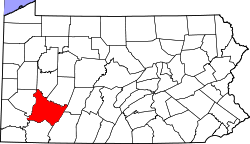
Arona is a borough in Westmoreland County, Pennsylvania, United States. The population was 253 at the 2020 census. [3]
Arona is located at 40°16′11″N79°39′38″W / 40.26972°N 79.66056°W (40.269740, -79.660429). [4]
According to the United States Census Bureau, the borough has a total area of 0.5 square miles (1.3 km2), all land.
Historical population | |||
---|---|---|---|
Census | Pop. | %± | |
1900 | 382 | — | |
1910 | 683 | 78.8% | |
1920 | 549 | −19.6% | |
1930 | 457 | −16.8% | |
1940 | 503 | 10.1% | |
1950 | 482 | −4.2% | |
1960 | 467 | −3.1% | |
1970 | 453 | −3.0% | |
1980 | 446 | −1.5% | |
1990 | 397 | −11.0% | |
2000 | 407 | 2.5% | |
2010 | 370 | −9.1% | |
2020 | 253 | −31.6% | |
2021 (est.) | 250 | [3] | −1.2% |
Sources: [5] [6] [7] [2] |
At the 2010 census there were 370 people, 153 households, and 108 families in the borough. The population density was 664.8 people per square mile (256.5/km²). There were 165 housing units at an average density of 311.3 per square mile (120.2/km²). The racial makeup of the borough was 100.0% White. [8] Of the 153 households 25.5% had children under the age of 18 living with them, 54.2% were married couples living together, 10.5% had a female householder with no husband present, and 29.4% were non-families. 24.8% of households were one person and 11.8% were one person aged 65 or older. The average household size was 2.42 and the average family size was 2.85.
The age distribution was 21.1% under the age of 18, 6.0% from 18 to 24, 26.5% from 25 to 44, 31.4% from 45 to 64, and 14.7% 65 or older. The median age was 42.4 years. For every 100 females, there were 97.9 males. For every 100 females age 18 and over, there were 100.0 males.
The median household income was $40,417 and the median family income was $61,875. Males had a median income of $38,876 versus $23,185 for females. The per capita income for the borough was $18,494. About 4.4% of families and 8.6% of the population were below the poverty line, including 7.1% of those under age 18 and 8.7% of those age 65 or over.
Whitaker is a borough in Allegheny County, Pennsylvania, United States, and is on the Monongahela River 3 miles (5 km) upriver from Pittsburgh. The population was 1,271 at the 2010 census.
Atwood is a borough in Armstrong County, Pennsylvania, United States. The population was 107 at the 2010 census.
Manorville is a borough in Armstrong County, Pennsylvania, United States. The population was 410 at the 2010 census.
Newell is a borough in Fayette County, Pennsylvania, United States. The population was 512 at the 2020 census. The town is served by the Frazier School District.
Plumville is a borough in Indiana County, Pennsylvania, United States. The population was 257 at the 2020 census.
Youngsville is a borough in Warren County, Pennsylvania, United States. The population was 1,729 at the 2010 census.
Centerville is a borough in Washington County, Pennsylvania, United States. The population was 3,254 at the 2020 census.
Long Branch is a borough in Washington County, Pennsylvania, United States. The population was 421 at the 2020 census.
New Eagle is a borough in Washington County, Pennsylvania, United States and is part of the Pittsburgh Metro Area. The population was 2,047 at the 2020 census.
North Charleroi is a borough in Washington County, Pennsylvania, United States. The population was 1,302 at the 2020 census.
Twilight is a borough in Washington County, Pennsylvania, United States. The population was 216 at the 2020 census.
Adamsburg is a borough in Westmoreland County, Pennsylvania, United States. The population was 144 at the time of the 2020 federal census.
East Vandergrift is a borough in Westmoreland County in the U.S. state of Pennsylvania. The population was 601 at the 2020 census.
Hunker is a borough in Westmoreland County, Pennsylvania, United States, which since 1950 has been part of the Pittsburgh metropolitan area. The population was 307 at the 2020 census.
Laurel Mountain is a borough in Westmoreland County, Pennsylvania, United States. The population was 185 at the 2000 census. Located at the foot of Laurel Mountain, the borough lies near numerous limestone caves and is surrounded by venues for skiing, hiking, and other outdoor activities.
Madison is a borough in Westmoreland County, Pennsylvania, United States. The population was 397 at the 2010 census. The borough was named for James Madison, fourth President of the United States.
New Alexandria is a borough in Westmoreland County, Pennsylvania, United States. The population was 560 at the 2010 census.
New Florence is a borough in Westmoreland County, Pennsylvania, United States. It was named for the city of Florence in Italy. The population was 689 as of the 2010 census, which is a decrease from 784 recorded by the 2000 census. It is also one of three communities within the county to utilise the 814 area code, alongside St. Clair and Seward.
Oklahoma is a borough in Westmoreland County, Pennsylvania, United States. The population was 809 at the 2010 census.
West Leechburg is a borough in Westmoreland County, Pennsylvania, United States, along the Kiskiminetas River. The population was 1,294 at the 2010 census.