Ci Liwung

Last updated
Ci Liwung
Sungai Ciliwung, Tji Liwoeng, Tjiliwoeng, Tjiliwung
Ciliwung 100303-0435 jkt.jpg
Lower Ci Liwung at Jakarta
Java Relief Map.svg
Red pog.svg
Indonesia relief location map.jpg
Red pog.svg
Location
Country Indonesia
Cities Jakarta, Depok, Bogor
Physical characteristics
Source 
 - location Mount Pangrango, Bogor Regency, West Java, Indonesia
 - coordinates 6°44′23″S106°56′59″E / 6.739846°S 106.949692°E / -6.739846; 106.949692
 - elevation3,002 m (9,849 ft)
Mouth  
 - location
North Jakarta, Jakarta, Indonesia
 - coordinates
6°07′00″S106°49′42″E / 6.11667°S 106.82833°E / -6.11667; 106.82833 Coordinates: 6°07′00″S106°49′42″E / 6.11667°S 106.82833°E / -6.11667; 106.82833
 - elevation
0 m (0 ft)
Length119 km (74 mi)
Basin size375 km2 (145 sq mi)
[1]
Ci Liwung ("K. Ciliwung "), bottom center in the map of rivers and canals of Jakarta (2012) Map of rivers and canals in Jakarta 2012.jpg
Ci Liwung ("K. Ciliwung "), bottom center in the map of rivers and canals of Jakarta (2012)

Ci Liwung (often written as Ciliwung; also as Tjiliwoeng in Dutch) is a 119 km long river in the northwestern region of Java where it flows through two provinces, West Java and the special region of Jakarta. The natural estuary of the Ciliwung river, known as the Kali Besar ("Big River"), was an important strategic point for trade in the precolonial and colonial periods and was instrumental in the founding of the port city of Jakarta, but has been lost from reorganization of the watercourse of the rivers around the area into canals.

Java island of Indonesia

Java is an island of Indonesia, bordered by the Indian Ocean on the south and the Java Sea on the north. With a population of over 141 million or 145 million, Java is the home to 56.7 percent of the Indonesian population and is the world's most populous island. The Indonesian capital city, Jakarta, is located on its northwestern coast. Much of Indonesian history took place on Java. It was the center of powerful Hindu-Buddhist empires, the Islamic sultanates, and the core of the colonial Dutch East Indies. Java was also the center of the Indonesian struggle for independence during the 1930s and 1940s. Java dominates Indonesia politically, economically and culturally. Four of Indonesia's eight UNESCO world heritage sites are located in Java: Ujung Kulon National Park, Borobudur Temple, Prambanan Temple, and Sangiran Early Man Site.

West Java Province in Indonesia

West Java is a province of Indonesia. It is located in the western part of the island of Java and its capital and largest urban center is Bandung, although much of its population in the northwest corner of the province live in areas suburban to the larger urban area of Jakarta, though that city itself lies outside the administrative province. With a population of 46.3 million West Java is the most populous of Indonesia's provinces.

Jakarta Special Capital Region in Indonesia

Jakarta, officially the Special Capital Region of Jakarta, is the capital and largest city of Indonesia. Located on the northwest coast of the world's most populous island Java, it is the centre of economics, culture and politics of Indonesia, with a population of 10,075,310 as of 2014. Jakarta metropolitan area has an area of 6,392 square kilometers, which is known as Jabodetabek. It is the world's second largest urban agglomeration with a population of 30,214,303 as of 2010. Jakarta is predicted to reach 35.6 million people by 2030 to become the world's biggest megacity. Jakarta's business opportunities, as well as its potential to offer a higher standard of living, attract migrants from across the Indonesian archipelago, combining many communities and cultures.

Contents

Etymology

The etymology of Ciliwung is uncertain; the two least implausible assumptions are "the whirlpool" (compare Sundanese liwung "be distressed, upset" and Javanese "madly turning around, be tormented") or "the meandering one" (compare Malay liuk, liut "to twist"). [2] It is possible that the name originated from one of the many epithets of the king of Pajajaran Sri Baduga Maharaja, among them is Prabu Haliwung, so named because of his temperamental attitude. The name Ci Haliwung was recorded in the map of C.M. Pleyte (1919). [3]

Sundanese language native language used by Sundanese people

Sundanese is a Malayo-Polynesian language spoken by the Sundanese. It has approximately 39 million native speakers in the western third of Java; they represent about 15% of Indonesia's total population.

Javanese language Austronesian language

Javanese is the language of the Javanese people from the central and eastern parts of the island of Java, in Indonesia. There are also pockets of Javanese speakers on the northern coast of western Java. It is the native language of more than 98 million people.

Malay language Austronesian language

Malay is a major language of the Austronesian family spoken in Brunei, Indonesia, Malaysia, and Singapore. A language of the Malays, it is spoken by 290 million people across the Strait of Malacca, including the coasts of the Malay Peninsula of Malaysia and the eastern coast of Sumatra in Indonesia, and has been established as a native language of part of western coastal Sarawak and West Kalimantan in Borneo. It is also used as a trading language in the southern Philippines, including the southern parts of the Zamboanga Peninsula, the Sulu Archipelago, and the southern predominantly Muslim-inhabited municipalities of Bataraza and Balabac in Palawan.

Geography

Upper Ci Liwung 50 km near its source in the Puncak area. Ciliwung at Puncak.JPG
Upper Ci Liwung 50 km near its source in the Puncak area.

Ci Liwung is 119 km long with a catchment area of 476 km2. The Ciliwung river has its source at Mandalawangi in Bogor Regency with the highest peak at 3,002 m. The river flows in a northern direction passing several active volcanoes, Mount Salak, Mount Kendeng, and Mount Halimun, crosses two main cities Bogor and Jakarta before finally flowing into the Java Sea through Jakarta Bay. The main tributaries in the upper catchment area are the Ciesek and Ciluar rivers with respective lengths 9.7 km and 21.0 km, with catchment areas of 27.15 km2 and 35.25 km2 respectively.

Bogor Regency Regency in West Java, Indonesia

Bogor Regency is a regency (kabupaten) of West Java, Indonesia, south of DKI Jakarta. It is considered a bedroom community for Jakarta, and is home to over five million people. Its administration is located in Cibinong.

Mount Salak mountain in West Java, Indonesia

Mount Salak is an eroded volcano in West Java, Indonesia. It has several satellite cones on its southeast flank and the northern foot, along with two additional craters at the summit. Mount Salak has been evaluated for geothermal power development. According to a popular belief, the name "Salak" derived from salak, a tropical fruit with scaly skin; however, according to Sundanese tradition, the name was derived from the Sanskrit word Salaka which means "silver". Mount Salak can be translated to "Silver Mountain" or "Mount Silver".

Mount Halimun

Mount Halimun is a mountain in the island of Java, Indonesia. It is protected by the Mount Halimun Salak National Park.

Ciliwung river basin has a narrow and elongated shape. The 17.2 km length of the upstream area has a very steep slope (0.08), The 25.4 km length in the middle-reach has a slope of 0.01 and the downstream, 55 km in length, has a flat slope of 0.0018. In general the geology of the upstream of Ciliwung river basin is dominated by Tuffaceous Breccia and older deposits lahar and lava. The middle-reach consists mainly of Quaternary period alluvial fans and volcanic rocks. The downstream area is dominated by alluvial and beach ridge deposits.

Lahar

A lahar is a violent type of mudflow or debris flow composed of a slurry of pyroclastic material, rocky debris and water. The material flows down from a volcano, typically along a river valley.

Lava Molten rock expelled by a volcano during an eruption

Lava is molten rock generated by geothermal energy and expelled through fractures in planetary crust or in an eruption, usually at temperatures from 700 to 1,200 °C. The structures resulting from subsequent solidification and cooling are also sometimes described as lava. The molten rock is formed in the interior of some planets, including Earth, and some of their satellites, though such material located below the crust is referred to by other terms.

Quaternary is the current and most recent of the three periods of the Cenozoic Era in the geologic time scale of the International Commission on Stratigraphy (ICS). It follows the Neogene Period and spans from 2.588 ± 0.005 million years ago to the present. The Quaternary Period is divided into two epochs: the Pleistocene and the Holocene. The informal term "Late Quaternary" refers to the past 0.5–1.0 million years.

Mean rainfall reaches 3,125 mm, with mean annual discharge of 16 m3/s as measured at Ciliwung Ratujaya observation station (231 km2). With such topographical, geological and hydrological features the Ciliwung river is often overflowing and inundating parts of Jakarta. The population along the Ciliwung river basin reaches 4.088 million (Census 2000) which can be regarded as the most densely populated area. [1]

Jakarta's canal

The natural flow of Ciliwung was diverted into canals by the Dutch during the early settlement of Jakarta (then named as Batavia). Beginning in area that is now Istiqlal Mosque, the Ciliwung was diverted into two canals, one flowing northwest and one flowing northeast.

The western branch flows along the canal of Jalan Veteran and then through the canal of Jalan Gajah Mada. This 2 km straight canal is known as Batang Hari canal, previously known as Molenvliet, which was dug in the 17th century. Formerly the water branches into two direction in Glodok, following the two course that is now Jalan Pancoran and Jalan Pinangsia Raya; today the water from Batang Hari canal was diverted east before Lindeteves Trade Center. Eventually the water ends up in Sunda Kelapa harbor after passing through the canals of Jakarta Old Town.

The eastern branch of Ci Liwung passing through a canal near Mangga Dua Square Mangga Dua Square.JPG
The eastern branch of Ci Liwung passing through a canal near Mangga Dua Square

The eastern branch flows along the canal of Jalan Antara, passing the Gedung Kesenian Jakarta and then along the canal of Jalan Gunung Sahari. The water ends up in Ancol.

Initially a canal links the eastern and the western branches of Ciliwung. Today this canal, which is now located on the south side of Jalan Tol Pelabuhan, was filled with slum settlement due to careless planning after the independence period.

After the 1918 Jakarta's big flood, a new canal, the Banjir canal ("flood canal"), was constructed in 1922 to divert the water of several rivers of Jakarta, which includes Ciliwung, Cideng, and Krukut. The flow of Ciliwung was diverted through the Manggarai floodgate, constructed at the point near Manggarai station. The water is diverted to the west of the city through Pasar Rumput, Dukuh Atas and going to northwest to Karet Kubur and continued to Tanah Abang, Tomang, Grogol, Pademangan, and ends at Muara Angke.

The New East Flood Canal has been opened since 2010, a 23 kilometers canal from Cipinang River to the east and then to the north of Java Sea as a quarter of a circle with 100 to 300 meters width. [4] On December 19, 2013 a contract to build water tunnel(s) to East Flood Canal from Ciliwung River with minimum capacity of 60 cubic meters per second has been signed by Public Works Ministry. [5] So, the floods in East Jakarta to the north and along the Ciliwung River will be eased.

Ciliwung-Cisadane tunnel

A coordination meeting on January 20, 2014 among the Ministry of Public Works, Ministry of Environment, Jakarta Governor, Bogor Mayor, Bogor Regent and Ciliwung-Cisadane Rivers Control Office agreed to build 1.2 kilometers tunnel from Ciliwung to Cisadane River with capacity 200 cubic meters per second to ease Ciliwung debit when Cisadane is not in flood condition. [6]

History

Kingdoms of Tarumanegara and Sunda

17th-century map of the area south of Batavia, showing River Ciliwung with outposts protecting the road from Batavia to Fort Padjajaran (now Bogor), the River Cisadane, and Citarik. Kaart van Batavia tot Zuid-Java.jpg
17th-century map of the area south of Batavia, showing River Ciliwung with outposts protecting the road from Batavia to Fort Padjajaran (now Bogor), the River Cisadane, and Citarik.

The Ciliwung River Basin has been populated at least since the 4th century. Two kingdoms were founded along the Upper Ciliwung in Bogor; Tarumanegara (4th-5th Century) with its King Purnawarman and Sunda (15th-16th Century) with its King Sri Baduga. The existence of these Kingdoms is found from ancient inscriptions at Ciaruteun (Tarumanagara) and Batutulis (Padjajaran). [1]

In the early 16th-century, Ciliwung was an important mean of transportation from the fortified city of Pakuan Pajajaran, the capital of Hindu Sunda Kingdom. Sunda Kelapa, located at the mouth of Ciliwung (more or less at the north end of present Kali Besar), was the main harbor of the Kingdom of Sunda. [7] Among the many epithets of the king Sri Baduga Maharaja, was Prabu Haliwungan - so called because of his temperamental attitude. The river Ci Haliwung or Ci Liwung was probably named after the king's epithet. The name Ci Haliwung or Tji Haliwoeng was recorded in the map of C.M. Pleyte (1919). [8]

During the rise of the Hindu Kingdom of Sunda, Ciliwung became the important mean of transportation for the kingdom. To protect Sunda Kelapa from the Islamic Sultanate of Cirebon and Demak, Prabu Surawisesa (recorded by the Portuguese as Samian) was instructed by the king to sign a peace treaty with the Portuguese to trade in pepper in exchange to a permission to built a fort to protect the main port of Sunda Kalapa. The pact was immortalized in a 1522 padrão. Despite the treaty, the Portuguese failed to construct the fort at the given year. The padrão of Sunda Kelapa was found by Fatahillah, commander of the Sultanate of Demak, and was fell into the Ciliwung without any ceremony. The padrão will only be rediscovered in 1918. [8]

VOC period

Within the walled Batavia

A map showing the transformation of the mouth of Ciliwung into canals flowing through the inner city and moat flowing around the city and the fort of Batavia. COLLECTIE TROPENMUSEUM Kaart voorstellende het Kasteel en de Stad Batavia in het jaar 1667 TMnr 496-2.jpg
A map showing the transformation of the mouth of Ciliwung into canals flowing through the inner city and moat flowing around the city and the fort of Batavia.

Sunda Kelapa was used as the main port by the Dutch (1619) who constructed a fort at the east bank of the estuary and founded Batavia, the largest city and the capital of the East Indies Empire, until the city was transformed into Jakarta after the independence of Indonesia. [9] Sultanate of Banten (1527) [9]

With the establishment of Batavia in the 17th century, the Dutch diverted Ciliwung into canals following a typical Dutch city pattern. The waters of Ciliwung was also channeled to form two inner and outer moats and a wall surrounding the city of Batavia. The largest canal which flows through the middle of Batavia was named Kali Besar or Dutch Grote Rivier ("Big River"). Small boats sailed along Ciliwung to transport goods from warehouses close to Kali Besar to ships anchored at the port. [10]

The maintenance of the canals within the walled city of Batavia is difficult because of its frequent sedimentation. In the middle of the 1630s, the canals became really shallow, making it difficult for ships to enter Batavia. In order to deal with this, an 800 m long ditch was constructed to the sea that was routinely dredged to ease the flow of water. The length of the ditch increased to 1,350 m (1827) from the mouth of the river due to accumulation of sand and mud and what more with the earthquake in January 1699 [10]

Ciliwung tributary that empties into the ocean was used for ship entrance into the castle from the canals to Waterpoort. The water of the canals were used by the citizens for drinking water. In 1689, the canals were still unpolluted and could be used for drinking water. The earthquake, which occurred in January 1699, caused the increase in sedimentation level. Heaps of mud and sand accumulated in the ditch that was dredged to ease the flow of the water to and from the river. [10]

In 1740, the canal of Batavia was considered unhealthy because of rubbish and the waste from the Binnen Hospital discharged into the river. Many patients suffered from dysentery and cholera. The unhygienic drinking water caused high death rates among the Batavia citizens. On the other hand, most of the Chinese who drank tea rarely got sick. Aware of this, many Dutch people ate tea leaves to stay healthy, but obviously this attempt did not succeed. By the end of the 18th century, Doctor Thunberg still prescribed tea leaves instead of boiled water. It was still unknown at that time that bacteria can be killed by boiling water until boiling point. The Dutch still drank water from Ciliwung through the 19th century. Water from Ciliwung was initially stored in a reservoir (waterplaats or aquada) near Fort Jacatra, north of the city. Later the reservoir was transferred to the sides of Molenvliet in Glodok area. The reservoir contains wooden water outlets which pour water from the height of about 10 feet. The local people knows the area around this reservoir as Pancuran. Back then when Molenvliet was deep enough for boats to sail, annual Peh Cun or Dragon Boat festival were held in the river. [10]

In the area surrounding Batavia

Outside Batavia, within the ommelanden (area surrounding Batavia), canals were constructed by channeling the waters of the rivers surrounding Batavia (e.g. Ciliwung, River Ancol, River Angke, River Krukut, and River Grogol). The creation of canals are mainly to improve transportation of goods to the walled city of Batavia and to expand agricultural land by draining the water of the marshes surrounding Batavia to be converted into arable land.

In 1648, the Ciliwung was connected with the Krukut via Molenvliet. [11] There was an attempt to close the Ciliwung river course north of Noordwijk. [12] The part of the river was dammed so that the river was forced to flow westward via Molenvliet. [12] Despite the attempt, seasonal flooding occurred where the Ciliwung forced its water to flow back to its old tributary, which was still happening around 1725. [12]

In 1681, the Ciliwung flow was diverted toward the east along the Postweg (now Jalan Pos) to reach a new canal known as Gunung Sahari Canal. Gunung Sahari Canal divert the flow of Ciliwung to reach the Java Sea to the north, near the mouth of River Ancol (now the canal near Dunia Fantasi). In the Gunung Sahari Canal, the Ciliwung merged again with its old course at the Krekot Sentiong area. The construction of Gunung Sahari canal caused frequent flooding in the area along the Noordwijk (now Jalan Ir. H. Juanda). Because of this, a lock was constructed at the west side of the Noordwijk (named schutsluis Noordwijk, later becoming the Willemsluis) to protect Noordwijk from flooding, The lock gives name to the streets surrounding the area Jalan Pintu Air ("water lock street"). [11]

The part of Ciliwung that flows straight from Harmoni to the north used to be a private river with toll payments for those who wanted to pass through it. This river was named Molenvliet and it was built by the Dutch by Kapitein der Chinezen (head of the Chinese in Betawi), Phoa Beng Gan known as Beng Gan. In 1648, Beng Gan received permission from the Company to build this river and collected toll payments from sampans that passed through. In 1654, it was taken over by the Company for 1.000 real.

Restoration

Today, the river water is murky once it reaches Jakarta because the area of its flow is a disposal area. As a result, the river is growing shallower and the flow slower. [10] In 2014, the Audit Board of Indonesia released a four-year audit of the river and found that seventeen separate companies had been polluting its waters, submitting a report to the police. [13]

A restoration project is undertaken to widen and water flow of the river. The restoration project is divided into four sections with a total length of about 19-km, extending from Manggarai to the Jl. TB Simatupang area in South Jakarta. Ciliwung will also be widened from present 25 meters up to 40 - 50 meters. It is expected that the water flow will increase from current 200 cubic meters per second to 570 cubic meters per second. [14]

Culture

The Ciliwung River flows through two provinces, West Java and the Special Region of Jakarta. Two main races dominate the region namely, the Sundanese (West Java) in southern Ciliwung and Orang Betawi (Jakarta) in northern Ciliwung.

Culture in the Bogor area is mainly Sundanese, such as can be observed from traditional dances, the Ketuk Tilu or the Jaipongan which is modern, sensual and full of spirit. Specific Sundanese music can be observed from the Degung, Calung, Angklung and Kecapi suling.

Culture of Jakarta can be seen in the Yapong dance and Gambang kromong as well as Kroncong music can still be found at Tugu, north of Jakarta. Also famous is a humorous play, the Lenong, using a special Betawi dialect.

Environment

The section of Ciliwung in Jakarta is heavily polluted. Informal settlements or slums flourished on the banks of Ciliwung, increasing the amount of waste and reducing the surface area of the river. Some canals was completely blocked by slums and people created informal gardens inside by drying the canal. Water maintenance and ecological awareness is minimal. Other sources of pollution originate from agricultural runoff of upstream river users and industrial pollution. [15] Flooding is a problem of Ciliwung. With many of the original forest converted into settlements around Puncak area, the flooding has worsened each year.

In 2012, the government of Indonesia announced a 20-year plan to clean up the Ciliwung river, which kicked off with a $10 million restoration project that will include the construction of a waste processing facility in 2013 [16] and an education centre for riverside communities. [17]   The city administration now hires over 4000 workers to regularly clean the city’s rivers, canals, lakes and coastal areas.  The former Governor Basuki Tjahaja Purnama also plans to turn parts of the Ciliwung riverbank into a tourist site. [18]

Related Research Articles

North Jakarta Administrative city in Jakarta, Indonesia

North Jakarta is one of the five administrative cities (kota) which form Special Capital Region of Jakarta, Indonesia. North Jakarta contains the entire coastal area within the Jakarta Special District. In North Jakarta, an area at the estuary of Ciliwung river was the main port for the kingdom of Tarumanegara, which later grew to become Jakarta. Many historic sites and artefacts of Jakarta can be found in North Jakarta. Both ports of Tanjung Priok and historic Sunda Kelapa are located in the city. The city, which had 1,645,312 inhabitants at the 2010 Census, has its administrative centre in Tanjung Priok.

Kemayoran district in Jakarta Pusat Administrative City, Indonesia

Kemayoran is a subdistrict of Central Jakarta, Indonesia. Kemayoran is roughly bounded by Landas Pacu Barat and Landas Pacu Timur road to the north, Letjend Suprapto Road to the south, and a canal along the Sunter Raya road to the northeast. The area is best known as the location of the former Kemayoran Airport, although the area of the former airport itself is actually located in two subdistrict, the northern part lies on the Subdistrict of Pademangan, North Jakarta while the southern part lies on the Subdistrict of Kemayoran, Central Jakarta. Kemayoran is the location of annual Jakarta Fair.

Sawah Besar Subdistrict in Special Capital City District of Jakarta, Indonesia

Sawah Besar is a subdistrict (kecamatan) of Central Jakarta, Indonesia. The neighborhoods within the subdistrict are among the most historic subdistrict in Jakarta, containing the 1820-established Pasar Baru, the colonial administrative center of Weltevreden, as well as the old course of the Ciliwung. Many colonial landmarks are located in the subdistrict, e.g. the Lapangan Banteng, the A.A. Maramis Building, and the Jakarta Cathedral.

Penjaringan district in Jakarta Utara Administrative City, Indonesia

Penjaringan is a subdistrict of North Jakarta, Indonesia. It is the westernmost Subdistrict of North Jakarta. Muara Angke Port and the mouth of Sunda Kelapa Port is located within Penjaringan. Penjaringan contains the remnants of the original mangrove forest of Jakarta, some is protected by the government. Penjaringan Subdistrict is crisscrossed with water draining channels, canals, and water reservoirs to protect the land from sea flooding. The Cengkareng Drain, part of Jakarta's flood control system, flows to the sea through this subdistrict.

History of Jakarta

Jakarta is Indonesia's capital and largest city. Located on an estuary of the Ciliwung River, on the northwestern part of Java, the area has long sustained human settlement. Historical evidence from Jakarta dates back to the 4th century CE, when it was a Hindu settlement and port. The city has been sequentially claimed by the Indianized kingdom of Tarumanegara, the Hindu Kingdom of Sunda, the Muslim Sultanate of Banten, and by Dutch, Japanese and Indonesian administrations. The Dutch East Indies built up the area before it was taken during World War II by the Empire of Japan and finally became independent as part of Indonesia.

Pakuan Pajajaran

Pakuan Pajajaran was the fortified capital city of Sunda kingdom. The location is roughly corresponds to modern Bogor city in West Java, Indonesia, approximately around the site of Batu Tulis. The site is revered as the spiritual home of Sundanese people as it contains much of shared identity and history of Sundanese people.

Sunda Kelapa

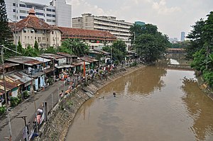
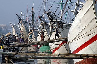
Sunda Kelapa is the old port of Jakarta located on the estuarine of Ciliwung River. "Sunda Kalapa" is the original name, and it was the main port of Hindu Sunda Kingdom of Pajajaran. The port is situated in Penjaringan sub-district, of North Jakarta, Indonesia. Today the old port only accommodate pinisi, a traditional two masted wooden sailing ship serving inter-island freight service in the archipelago. Although it is now only a minor port, Jakarta has its origins in Sunda Kelapa and it played a significant role in the city's development.

Ancol Administrative village in Special Capital City District of Jakarta, Indonesia

Ancol is a coastal lowland area located to the east of Kota Tua Jakarta in northern Jakarta, in Indonesia. The coastal lowland stretched from Kota Tua Jakarta to the west and Tanjung Priok to the east. Today, Ancol contains the main beach resort of Jakarta. Taman Impian Jaya Ancol, the largest integrated tourism area in South East Asia, is located in Ancol.

Kwitang is an administrative village (kelurahan) in the subdistrict (kecamatan) of Senen, Central Jakarta. It is one of the historic administrative village of Jakarta. The boundary of Kwitang is the Ciliwung to the west, Jalan Kramat Kwitang to the north, Jalan Kramat Raya to the east, and Jalan Kramat 4 to the south.

Jakarta Flood Canal

The Jakarta Flood Canal refers to two canals that divert floods from rivers around Jakarta instead of going through the city. This first flood control channel was designed by Hendrik van Breen, engineer at the Burgelijke Openbare Werken or BOW, after a big flood hit the city on 13 February 1918.

Angke River river in Indonesia

Angke River is a 91.25 kilometres (56.70 mi) long river in Jakarta, Indonesia. The river flows from Bogor area of West Java, passing through the cities of Tangerang (Banten) and Jakarta into the Java Sea via the Cengkareng Drain.

Jalan Gajah Mada and Jalan Hayam Wuruk area in Jakarta, ID

Jalan Gajah Mada and Jalan Hayam Wuruk, formerly Molenvliet West and Molenvliet Oost respectively, is a major thoroughfare located in Jakarta, Indonesia. The two streets with its canal, the Batang Hari, connected Glodok and Kota Tua Jakarta to the north with Harmoni Junction to the south. Completed in late 1640s, the canal-street Gajah Mada and Hayam Wuruk is Jakarta's oldest major thoroughfare.

Mookervaart River

Mookervaart River is a canal connecting the Cisadane River in Tangerang and Kali Angke in Jakarta. Constructed from 1678 to 1689, this 25-30 meter wide channel is one of the important flood control water channels in Jakarta.

Krukut River river in Indonesia

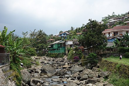
Krukut River is a river flowing in Jakarta from a source in Bogor Regency. In the past the river was clean and one of the tourist attractions during the Dutch East Indies administration, but due to denser housing on the banks and lack of maintenance, the water turned dark and filled with trash, causing routine flooding in rainy seasons.

Jatikramat River river in Indonesia

Jatikramat River is a river in the Bekasi, West Java and eastern part of the Special Capital Region of Jakarta, Indonesia. The lower portions of the original river have been channelized and directed into the eastern flood canal, "Banjir Kanal Timur", which continues to flow to the Java Sea in the district of Marunda, Cilincing, North Jakarta. The river regularly causes flooding in the city of Bekasi and Jakarta.

Cakung River river in Indonesia

Cakung River is a river in the Bekasi, West Java and eastern part of the Special Capital Region of Jakarta, Indonesia. The lower portions of the original river have been channelized and directed into the eastern flood canal, "Banjir Kanal Timur", which continues to flow to the Java Sea in the district of Marunda, Cilincing, North Jakarta. The river regularly causes flooding in the city of Bekasi and Jakarta.

Sunda Kelapa lighthouse lighthouse in Indonesia

Sunda Kelapa lighthouse is a lighthouse located in Jakarta, Indonesia. Established in the mid 19th-century, it is among the oldest modern lighthouse in Indonesia.

Baru Timur River

Baru Timur River is a man-made canal flowing from Ci Liwung in Bogor Regency to Jakarta, Indonesia. It was one of two canals built in 18th century under the order of the Governor-General Gustaaf Willem van Imhoff originally to transport agriculture harvest from Bogor to Batavia. Currently both canals, now known as Kali Baru Timur and Kali Baru Barat, are among the main rivers in Jakarta, and part of the Ciliwung Cisadane flood control project. Baru Timur River flows from Katulampa flood gate, built at the same time as the canal, along the major road Bogor Highway, passing Cimanggis, Depok, Cilangkap, until reaching Java Sea in Kali Besar, Tanjung Priok, North Jakarta.

Baru Barat River

Baru Barat River is a man-made canal flowing from Cisadane River in Bogor Regency to Jakarta, Indonesia. It was one of two canals built in 18th century under the order of the Governor-General Gustaaf Willem van Imhoff originally to transport agriculture harvest from Bogor to Batavia. Currently both canals, now known as Kali Baru Timur and Kali Baru Barat, are among the main rivers in Jakarta, and part of the Ciliwung Cisadane flood control project. Flowing through the areas of Pancoran and Tebet, South Jakarta, among others, Baru Barat River is one of the drainages that flow the water into Banjir Kanal Barat.

Outline of Jakarta Place

The following outline is provided as an overview of and topical guide to Jakarta:

References

  1. 1 2 3 DPRI Ciliwung Archived 2013-12-03 at the Wayback Machine
  2. Grijns, Kees; Nas, Peter J. M., eds. (2000). Jakarta-Batavia: Socio-cultural Essays. Leiden: KITLV Press. p. 220. ISBN   90-6718-139-0.
  3. Mulyawan Karim 2009, p. 98.
  4. "Proyek Banjir Kanal Timur" . Retrieved January 15, 2014.
  5. "Rp500 Billion for Ciliwung River Tunnel Construction" . Retrieved January 15, 2014.
  6. Indah Setiawati and Theresia Sufa (January 21, 2014). "Two reservoirs, big tunnel planned to ease flooding".
  7. Drs. R. Soekmono, (1973, 5th reprint edition in 1988). Pengantar Sejarah Kebudayaan Indonesia 2, 2nd ed. Yogyakarta: Penerbit Kanisius. p. 60.Check date values in: |date= (help)
  8. 1 2 Mulyawan Karim 2009, pp. 98-9.
  9. 1 2 "History of Jakarta". BeritaJakarta. Archived from the original on 2011-08-20.
  10. 1 2 3 4 5 "Ciliwung, Sungai". Ensiklopedi Jakarta. Department of Communication, Informatics and Public Relations of Jakarta Capital City. 2012. Retrieved November 27, 2013.
  11. 1 2 Mulyawan Karim 2009, pp. 91-2.
  12. 1 2 3 de Haan 1935, pp. 397,399.
  13. Fitrian Ardiansyah, Andri Akbar Marthen, and Nur Amalia, Forest and land-use governance in a decentralized Indonesia: A legal and policy review, pg. 32. Bogor: Center for International Forestry Research, 2015. ISBN   9786023870103
  14. "Ciliwung restoration reaches 34 percent completion". The Jakarta Post. Retrieved 7 September 2017.
  15. "Polluted Rivers: The Ciliwung". HydrateLife. 2012-07-20. Retrieved 2016-10-10.
  16. "CILIWUNG, PILOT PROJECT OF INDONESIA'S RIVER CLEAN-UP PROGRAM by Fardah". fardahassegaf.blogspot.sg. Retrieved 2016-10-10.
  17. Post, The Jakarta. "South Korea to help in restoring Ciliwung River". The Jakarta Post. Retrieved 2016-10-10.
  18. Post, The Jakarta. "Jakarta seeing results with cleaner rivers". The Jakarta Post. Retrieved 2016-10-10.

Sources