Harishchandragad is a hill fort in the Ahmednagar district of India. Its history is linked with that of Malshej Ghat, kothale village and it has played a major role in guarding and controlling the surrounding region.

Tikona also known as Vitandgad) is the dominant hill fort in Maval in western India. It is located near Kamshet around 60 km from Pune. The village nearest to the fort is called Tikona-Peth. The 3500 ft high hill is pyramidal in shape and the name Tikona means "triangular".

Ratangad is a fort in Ratan Wadi, Maharashtra, India, overlooking the locale of Bhandardara, one of the oldest artificial catchment area. This fort is located in the Ahmadnagar district of Maharashtra. It is on the boundary of Ahmadnagar and Thane districts. The fort is about 400 years old. This fort is often covered with flowering plants in November. Ratangad is also called Jewels of the Fort.

Ramsej or Ramshej Fort (Marathi: रामशेज किल्ला) is a small fort located 10 kilometres (6.2 mi) north-west of Nashik, in the Indian state of Maharashtra.There is a story that Lord Rama stayed for a while on this fort while going to Sri Lanka. This fort can be visited in a day from Nashik. This fort is located on the busy Nashik-Vapi Route.

Jivdhan is a hill fortress situated 1 km near the modern day town of Ghatghar in Junnar Taluka of Pune district in Maharashtra, India. The fort, which rises 1,145 meters above sea level, is located in the Sahyadri mountain range. The fort was looted and destroyed by the British upon siege between 1815 -1818 Jivdhan is a part of the 'Famous 5' trekking destinations among trekking enthusiasts. Chavaand, Hadsar, Shivneri, and Naneghat are the other destinations in the Famous 5 trek. This is a high difficulty grade trek due to the misleading jungle tracks and the necessity and knowledge of using climbing equipment. The rock cut steps are wonderfully carved, which lead to the kalyan gate. There are hooks attached on the walls of the rock cut steps near kalyan gate, which makes it easy for regular climber.

Rohida fort / Vichitragad Fort is a fort located 10 km from Bhor, Pune district, of Maharashtra. This fort is an important fort in Pune district. The fort restoration is done by the Shree Shivdurga Samvardhan committee with the help of forest dept. and local villagers.

Kenjalgad Fort in Wai, Maharashtra is a fort eleven miles (18 km) north-west of Wai. It is located on the Mandhardev spur of the Mahadev hill range. The fort is visible from quite a long distance as a stone scarp 30–40 feet high rising as a cap on the irregular hill.The fort is rhomboid in shape with 388m long axis and 175m short axis.

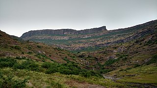
Ankai Fort( Marathi: अंकाई / अणकाई किल्ला ) is a historic site found in the Satmala Range hills in western India. It is located in Yeola Taluka of Nashik district in the state of Maharashtra. Geographically, it is near Manmad. The Ankai fort and Tankai fort are two different forts on adjacent hills. A common fortification is constructed to secure both. The Ankai fort is located on a hill with perpendicular scarps on all the sides, except for a narrow nose on the eastern side.

Ghangad is a fort situated near 30km from Lonavla-Khandala and 100 km from Pune in Maharashtra state, India.This fort is an important fort in the Pune district. The fort restoration is done by the Shivaji Trail group with the help of local villagers. The fort is at least 300 years old. Restoration work took place in 2011-12.

Tringalwadi fort is located in the Igatpuri taluka of Nashik district. It is located on the ancient trade route passing through Thal ghat. The fort is located near village Tringalwadi. The Tringalwadi irrigation dam which is close to the village was built in 1978

Surgad, is a hill fort located in a spur, fragmented from the Sahyadri ranges of Maharashtra. The fort is situated near Roha, next to the village of Gherasurgad in the Raigad district. This fort was an observation fort, which guarded the trade route along the Kundalika river from Sudhagad to Revdanda fort.

Bhaskargad fort / Basgad Fort is a fort located 48 km from Igatpuri, Nashik district, of Maharashtra. This fort is one of the fort in Trimbak hill range. This fort is near to the Harihar fort.

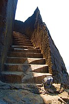
Harihar fort / Harshagad is a fort located 40km from Nashik City, 48 km from Igatpuri, 40 km from Ghoti in Nashik district, of Maharashtra. It is an important fort in Nashik district, and was constructed to look upon the trade route through Gonda Ghat. It receives many visitors because of its peculiar rock-cut steps.
Indrai Fort / Indragiri Fort is a fort located 75 km from Nashik,in Nashik district, of Maharashtra. This fort though is an important fort in Nashik district but, it is less visited by the trekkers. In Chandwad taluka, there are 4 forts in a line on the Satmal hill range, the Chandwad fort, Indrai fort, Rajdher fort, and Koldher fort. This fort is easy to climb but requires 3 hours to reach the fort.

Peb Fort / Vikatgad Fort(Marathi: पेब किल्ला / विकटगड) is a fort located 19km from Karjat, in Raigad district, of Maharashtra. This fort is in continuation with the Malang gad, Tauli Hill and Chanderi fort of the Matheran Hill Range. Vikatgad is a favourite destination for one-day trekkers. The trek path to Vikatgad is along deep ravines and cliffs. Its closeness to Matheran and Neral attracts many trekkers on weekends. The forest department and local villagers are doing plantation and some restoration works on the fort.
Rajdeher Fort (Marathi: राजधेर किल्ला) is a fort located 10 km (6.2 mi) from chandwad, Nashik district, of Maharashtra. This fort is an important fort in Nashik district.

Gorakhgad Fort / गोरखगड is a fort located 24 km from Murbad, Thane district, of Maharashtra. This fort is an important fort in Thane district. This fort was mainly used by sadhus or hermits for meditation.and also by local people's of surrounding village, It was also used to guard the ancient trade route passing through Naneghat.

Hatgad Fort is a fort located 71 km (44 mi)from Nashik, Nashik district, of Maharashtra. The base village is Hatgad on the Nashik-Saputara Road. The nearest town is Saputara, which is 6 km from Hatgad village.It is a historic monument located in Maharashtra, India, south of the hill station of Saputara and near the border with Gujarat. It was built by the Maratha king Shivaji and is located at an elevation of about 3,600 feet. The only way to reach the fort is through a trekking route via a narrow rocky path. A statue of Lord Ganesha is placed on the top of the fort.
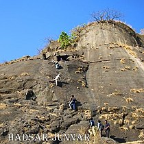
Nimgiri- Hanumantgad Fort is Located in Junnar taluka of Pune district in Maharashtra. These two forts jointly form two peaks on a same hill. It is one of the seven important forts along with Hadsar, Chavand, Shivneri, Jivdhan, Narayangad and Sindola forts that protected the trade route during medieval period from Junnar to Kalyan port through Naneghat. This is a fort located 25 km (16 mi) from the Junnar town.
Pabargad Fort is a fort located 50 km (31 mi)from Igatpuri via Bhandardara. The fort is in Akole taluka in Ahmednagar district, of Maharashtra. The trek to this fort is difficult.