
The emperor penguin is the tallest and heaviest of all living penguin species and is endemic to Antarctica. The male and female are similar in plumage and size, reaching 100 cm (39 in) in length and weighing from 22 to 45 kg. Feathers of the head and back are black and sharply delineated from the white belly, pale-yellow breast and bright-yellow ear patches.

The Weddell Sea is part of the Southern Ocean and contains the Weddell Gyre. Its land boundaries are defined by the bay formed from the coasts of Coats Land and the Antarctic Peninsula. The easternmost point is Cape Norvegia at Princess Martha Coast, Queen Maud Land. To the east of Cape Norvegia is the King Haakon VII Sea. Much of the southern part of the sea is covered by a permanent, massive ice shelf field, the Filchner-Ronne Ice Shelf.

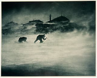
Halley Research Station is a research facility in Antarctica on the Brunt Ice Shelf operated by the British Antarctic Survey (BAS). The base was established in 1956 to study the Earth's atmosphere. Measurements from Halley led to the discovery of the ozone hole in 1985. The current base is the sixth in a line of structures and includes design elements intended to overcome the challenge of building on a floating ice shelf without being buried and crushed by snow. As of 2020, the base has been left unstaffed through winter since 2017, due to concerns over the propagation of an ice crack and how this might cut off the evacuation route in an emergency. The Halley Bay Important Bird Area with its emperor penguin colony lies in the general vicinity of the base.

Berkner Island is an Antarctic ice rise, where bedrock below sea level has caused the surrounding ice sheet to create a dome. If the ice cap were removed, the island would be underwater. Berkner Island is completely ice-covered and is about 320 kilometres (200 mi) long and 150 kilometres (93 mi) wide, with an area of 44,000 km2 (17,000 sq mi). It is surrounded by the Filchner-Ronne Ice Shelf. The northernmost point of the Berkner is about 20 kilometres (12 mi) from the open sea. It lies in the overlapping portion of the Argentine and the British Antarctic territorial claims.

The Brunt Ice Shelf borders the Antarctic coast of Coats Land between Dawson-Lambton Glacier and Stancomb-Wills Glacier Tongue. It was named by the UK Antarctic Place-names Committee after David Brunt, British meteorologist, Physical Secretary of the Royal Society, 1948–57, who was responsible for the initiation of the Royal Society Expedition to this ice shelf in 1955.

Shackleton Ice Shelf is an extensive ice shelf fronting the coast of East Antarctica from 95° E to 105° E. It extends for an along-shore distance of about 384 kilometres (239 mi), projecting seaward about 145 kilometres (90 mi) in the western portion and 64 kilometres (40 mi) in the east. It occupies an area of 33,820 square kilometres (13,058 sq mi). It is part of Mawson Sea and separates the Queen Mary Coast to the west from the Knox Coast of Wilkes Land to the east.

The West Ice Shelf is a prominent ice shelf extending about 350 km (220 mi) in an east–west direction along the Leopold and Astrid Coast in East Antarctica between Barrier Bay and Posadowsky Bay, and up to 120 km northwards from the continental margin.

Beaufort Island is an island in Antarctica's Ross Sea. It is the northernmost feature of the Ross Archipelago, lying 21 kilometres north of Cape Bird, Ross Island. It is approximately 18.4 km2 in area. It was first charted by James Clark Ross in 1841. Ross named the island for Sir Francis Beaufort, hydrographer to the British Royal Navy.
Cape Denison is a rocky point at the head of Commonwealth Bay in George V Land, Antarctica. It was discovered in 1912 by the Australasian Antarctic Expedition (1911–14) under Douglas Mawson, who named it for Sir Hugh Denison of Sydney, a patron of the expedition. The cape was the site of the expedition's main base. Called by Mawson "the windiest place on Earth", the site experiences fierce katabatic winds.

Mertz Glacier is a heavily crevassed glacier in George V Coast of East Antarctica. It is the source of a glacial prominence that historically has extended northward into the Southern Ocean, the Mertz Glacial Tongue. It is named in honor of the Swiss explorer Xavier Mertz.
Princess Ragnhild Coast is the portion of the coast of Queen Maud Land in Antarctica lying between 20° E and the Riiser-Larsen Peninsula, at 34° E. All but the eastern end of the coast is fringed by ice shelves. It was discovered by Capt. Hjalmar Riiser-Larsen and Capt. Nils Larsen in aerial flights from the ship Norvegia on February 16, 1931, and named for Princess Ragnhild of Norway. Vestvika Bay is a large bay on the west side of Riiser-Larsen Peninsula; it was mapped from air photos taken by the Lars Christensen Expedition, 1936–37, and named Vestvika, meaning "west bay."

Riiser-Larsen Ice Shelf is an ice shelf about 250 miles (400 km) long on the coast of Queen Maud Land, Antarctica, extending from Cape Norvegia in the north to Lyddan Island and Stancomb-Wills Glacier in the south.

Cape Adare is a prominent cape of black basalt forming the northern tip of the Adare Peninsula and the north-easternmost extremity of Victoria Land, East Antarctica.
The McDonald Ice Rumples constitute an ice rise in the Brunt Ice Shelf bordering the Weddell Sea in Antarctica, covering an area of 3 by 2 nautical miles.
Emperor Bay was a small bay on the Brunt Ice Shelf due west of Halley Station. It was so named by the Royal Society International Geophysical Year expedition because of the emperor penguin colony on the fast ice in the embayment during 1956. The expedition's base was a few miles eastward (1955–59) on the Brunt Ice Shelf.

The Dawson-Lambton Glacier is a heavily crevassed glacier entering the south-eastern Weddell Sea immediately west of the Brunt Ice Shelf. It was discovered in January 1915 by a British expedition led by Ernest Shackleton. He named it for Elizabeth Dawson-Lambton, a benefactress of the Shackleton expeditions.
Vapour Col is a col lying south of Stonethrow Ridge on the west side of Deception Island in the South Shetland Islands of Antarctica. The name given by the United Kingdom Antarctic Place-Names Committee (UK-APC) in 1959 originates from the fumaroles in the col. This is the only locality on Deception Island where there is a complete cross section through the stratigraphy of volcanic succession. Having a similar name in the same island is the Fumarole Bay.

Taylor Rookery is an emperor penguin breeding colony on the Mawson Coast of Mac. Robertson Land in East Antarctica. It is the larger of the two known entirely land-based colonies of the species, most of which are situated on sea ice.
Amanda Bay, also sometimes known as Hovde Cove, lies in southern Prydz Bay on the Ingrid Christensen Coast of Princess Elizabeth Land, East Antarctica. It is best known for its breeding colony of several thousand pairs of emperor penguins on sea ice at the south-west corner of the bay.
Muskegbukta is a small bay on the west of the Fimbul Ice Shelf, on the Princess Martha Coast of Queen Maud Land, Antarctica.
