Highest mountains in Austria
This table lists about 150 Austrian summits above 3150 m with a topographic prominence of at least 150 m and nine peaks of note with a slightly lower re-ascent. Only those mountains with a prominence of 150 m or more are ranked.
| Rank | Image | Mountain | Height (m) [1] | Region [2] | Range | Coordinates | Isolation (km) | Prominence (m) [3] | First ascent [4] |
|---|---|---|---|---|---|---|---|---|---|
| 1 |  | Großglockner | 3798 | Ca/ET | Glockner Group Hohe Tauern | 47°04′27″N12°41′40″E / 47.07417°N 12.69444°E | 174.6 Königspitze | 2,428 Brenner Pass | 1800 |
| 2 |  | Wildspitze | 3770 | NT | Ötztal Alps Weißkamm | 46°53′07″N10°52′02″E / 46.88528°N 10.86722°E | 48.5 Ortler | 2,263 Reschen Pass | 1848 |
| 3 |  | Weißkugel | 3739 | NT/ST | Ötztal Alps Weißkamm | 46°47′52″N10°43′35″E / 46.79778°N 10.72639°E | 14.9 Wildspitze | 569 Langtauferer Joch | 1845 [5] |
 | Glocknerwand | 3721 | Ca/ET | Glockner Group Hohe Tauern | 47°04′45″N12°41′12″E / 47.07917°N 12.68667°E | 0.8 Großglockner | 132 Untere Glocknerscharte | 1872 | |
| 4 |  | Großvenediger | 3666 | ET/Sb | Venediger Group Hohe Tauern | 47°06′33″N12°20′47″E / 47.10917°N 12.34639°E | 26.1 Glocknerwand | 1,185 Felbertauern | 1841 |
| 5 |  | Hintere Schwärze | 3628 | NT/ST | Ötztal Alps Maine Ridge | 46°46′24″N10°54′53″E / 46.77333°N 10.91472°E | 13.3 Wildspitze | 838 Hochjoch | 1867 |
| 6 |  | Hinterer Brochkogel | 3628 | NT | Ötztal Alps Weißkamm | 46°53′10″N10°50′59″E / 46.88611°N 10.84972°E | 0.9 Wildspitze | 160 Mitterkarjoch | 1858 |
| 7 |  | Similaun | 3599 | NT/ST | Ötztal Alps Maine Ridge | 46°45′49″N10°52′51″E / 46.76361°N 10.88083°E | 2.8 Hintere Schwärze | 261 Similaunjoch | 1834 |
| 8 |  | Vorderer Brochkogel | 3565 | NT | Ötztal Alps Weißkamm | 46°52′29″N10°51′03″E / 46.87472°N 10.85083°E | 1.1 Hinterer Brochkogel | 165 Vernagtjoch | 1851 |
| 9 |  | Großes Wiesbachhorn | 3564 | Sb | Glockner Group Hohe Tauern | 47°09′23″N12°45′19″E / 47.15639°N 12.75528°E | 9.7 Glocknerwand | 481 Gruberscharte | 1795 [6] |
| 10 |  | Rainerhorn | 3559 | ET | Venediger Group Hohe Tauern | 47°06′03″N12°21′51″E / 47.10083°N 12.36417°E | 1.3 Großvenediger | 153 Rainertörl | 1859 |
| 11 |  | Großer Ramolkogel | 3550 | NT | Ötztal Alps Maine Ridge | 46°50′48″N10°57′32″E / 46.84667°N 10.95889°E | 7.9 Wildspitze | 380 Fanatjoch | 1862 |
| 12 |  | Schalfkogel | 3540 | NT | Ötztal Alps Maine Ridge | 46°48′06″N10°57′33″E / 46.80167°N 10.95917°E | 4.5 Hintere Schwärze | 351 Ramoljoch | 1830 |
| 13 |  | Hochvernagtspitze | 3535 | NT | Ötztal Alps Weißkamm | 46°52′53″N10°47′46″E / 46.88139°N 10.79611°E | 4.0 Hinterer Brochkogel | 299 Taschachjoch | 1865 |
| 14 |  | Watzespitze | 3533 | NT | Ötztal Alps Kaunergrat | 46°59′22″N10°47′44″E / 46.98944°N 10.79556°E | 12.1 Hochvernagtspitze | 489 Ölgrubenjoch | 1869 |
| 15 |  | Langtauferer Spitze | 3529 | NT/ST | Ötztal Alps Weißkamm | 46°48′17″N10°44′45″E / 46.80472°N 10.74583°E | 1.4 Weißkugel | 173 Weißkugeljoch | 1865 |
 | Mutmalspitze | 3528 | NT | Ötztal Alps Maine Ridge | 46°46′59″N10°54′28″E / 46.78306°N 10.90778°E | 1.1 Hintere Schwärze | 138 Hintere Schwärzenjoch | 1868 | |
| 16 |  | Weißseespitze | 3518 | NT/ST | Ötztal Alps Weißkamm | 46°50′48″N10°43′02″E / 46.84667°N 10.71722°E | 5.1 Langtauferer Spitze | 350 Gepatschferner | 1870 |
| 17 |  | Fineilspitze | 3514 | NT/ST | Ötztal Alps Maine Ridge | 46°46′49″N10°49′55″E / 46.78028°N 10.83194°E | 4.1 Similaun | 504 Niederjoch | 1865 |
| 18 |  | Hochfeiler | 3510 | NT/ST | Zillertal Alps Main ridge | 46°58′20″N11°43′40″E / 46.97222°N 11.72778°E | 49.0 Großvenediger | 982 East of Hörndljoch | 1865 |
| 19 |  | Zuckerhütl | 3507 | NT | Stubai Alps | 46°57′52″N11°09′14″E / 46.96444°N 11.15389°E | 19.6 Ramolkogel | 1,033 Timmelsjoch | 1863 |
| 20 |  | Dreiherrnspitze | 3499 | ET/Sb/ST | Venediger Group Hohe Tauern | 47°04′09″N12°14′27″E / 47.06917°N 12.24083°E | 8.8 Großvenediger | 581 Obersulzbachtörl | 1866 |
| 21 |  | Schrankogel | 3497 | NT | Stubai Alps | 47°02′38″N11°05′57″E / 47.04389°N 11.09917°E | 9.7 Zuckerhütl | 523 Eissatel (N of Hinterer Daunkopf) | 1840 [6] |
| 22 |  | Fluchtkogel | 3497 | NT | Ötztal Alps Weißkamm | 46°51′28″N10°47′33″E / 46.85778°N 10.79250°E | 2.5 Hochvernagtspitze | 256 Gepatschjoch | 1869 |
| 23 |  | Rötspitze | 3496 | ET/ST | Venediger Group Hohe Tauern | 47°01′37″N12°12′19″E / 47.02694°N 12.20528°E | 5.5 Dreiherrenspitze | 653 Hinteres Umbaltörl | 1854 |
| 24 |  | Firmisanschneide | 3491 | NT | Ötztal Alps Maine Ridge | 46°49′11″N10°57′13″E / 46.81972°N 10.95361°E | 2.0 Schalfkogel | 204 Firmisanjoch | 1870 |
| | Simonyspitzen | 3488 | ET/Sb | Venediger Group Hohe Tauern | 47°04′22″N12°15′42″E / 47.07278°N 12.26167°E | 1.6 Dreiherrenspitze | 117 Umbalscharte | 1871 | |
| 25 |  | Hintereisspitzen | 3486 | NT/ST | Ötztal Alps Weißkamm | 46°49′22″N10°45′51″E / 46.82278°N 10.76417°E | 2.3 Langtaufererspitze | 270 Kesselwandjoch | 1875 |
| 26 |  | Großer Möseler | 3480 | NT/ST | Zillertal Alps Main ridge | 46°59′33″N11°46′55″E / 46.99250°N 11.78194°E | 4.7 Hochfeiler | 455 Neveser Sattel | 1865 |
| 27 |  | Hochwilde | 3480 | NT/ST | Ötztal Alps Maine Ridge | 46°45′56″N11°01′20″E / 46.76556°N 11.02222°E | 6.1 Schalfkogel | 355 SW of Gurgler Eisjoch | 1852 |
| 28 |  | Olperer | 3476 | NT | Zillertal Alps Tuxer Kamm | 47°03′11″N11°39′32″E / 47.05306°N 11.65889°E | 10.4 Hochfeiler | 1,230 Pfitscherjoch | 1867 |
| 29 |  | Ruderhofspitze | 3474 | NT | Stubai Alps | 47°02′22″N11°08′36″E / 47.03944°N 11.14333°E | 3.4 Schrankogel | 370 Schwarzenbergjoch | 1864 |
| 30 |  | Hinterer Seelenkogel | 3472 | NT/ST | Ötztal Alps Maine Ridge | 46°48′06″N11°02′40″E / 46.80167°N 11.04444°E | 4.3 Hochwilde | 441 Langtaler Joch | 1871 |
| 31 | | Karlesspitze | 3462 | NT/ST | Ötztal Alps Maine Ridge | 46°46′21″N10°58′29″E / 46.77250°N 10.97472°E | 3.2 Schalfkogel | 192 Kleinleitenjoch | 1869 |
 | Wilder Pfaff | 3456 | NT/ST | Stubai Alps | 46°57′57″N11°09′52″E / 46.96583°N 11.16444°E | 0.75 Zuckerhütl | 116 Pfaffensattel | 1870 | |
| 32 |  | Kreuzspitze | 3455 | NT | Ötztal Alps Maine Ridge | 46°48′59″N10°52′12″E / 46.81639°N 10.87000°E | 4.9 Fineilspitze | 228 N of Sennkogel | 1865 |
| 33 |  | Bliggspitze [7] | 3454 | NT | Ötztal Alps Kaunergrat | 46°55′05″N10°47′10″E / 46.91806°N 10.78611°E | 4.1 Hochvernagtspitze | 387 N of Eiskastenspitze | 1874 |
| 34 | 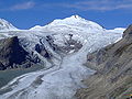 | Johannisberg | 3453 | Ca/Sb | Glockner Group Hohe Tauern | 47°06′34″N12°40′22″E / 47.10944°N 12.67278°E | 2.1 Romariswandköpfe | 293 Unt. Ödenwinkelscharte | 1844 |
| 35 | 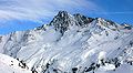 | Vordere Ölgrubenspitze [7] | 3452 | NT | Ötztal Alps Kaunergrat | 46°54′30″N10°46′24″E / 46.90833°N 10.77333°E | 1.5 Vordere Ölgrubenspitze | 244 Bliggschartl | 1876 |
| 36 |  | Sonklarspitze | 3444 | NT/ST | Stubai Alps | 46°57′22″N11°09′52″E / 46.95611°N 11.16444°E | 1.4 Zuckerhütl | 169 Sonklarscharte | 1869 |
| 37 | 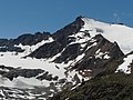 | Hinterer Brunnenkogel | 3440 | NT | Ötztal Alps Weißkamm | 46°54′46″N10°51′41″E / 46.91278°N 10.86139°E | 1.9 Schuchtkogel | 274 Mittelbergjoch | 1873 |
 | Hochgall [8] | 3436 | ST/ET | Rieserferner Group Hohe Tauern | 46°54′39″N12°08′23″E / 46.91083°N 12.13972°E | 13.7 Rötspitze | 1,148 Klammjoch | 1868 | |
| 38 | | Hintere Spiegelkogel | 3426 | NT | Ötztal Alps Maine Ridge | 46°49′45″N10°57′32″E / 46.82917°N 10.95889°E | 1.1 Firmisanschneide | 175 Spiegeljoch | 1870 |
| 39 |  | Verpeilspitze | 3425 | NT | Ötztal Alps Kaunergrat | 47°00′12″N10°48′18″E / 47.00333°N 10.80500°E | 1.6 Watzespitze | 415 Schneeiges Madatschjoch | 1886 |
| 40 | 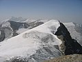 | Klockerin | 3425 | Sb | Glockner Group Hohe Tauern | 47°08′50″N12°44′10″E / 47.14722°N 12.73611°E | 1.6 Großes Wiesbachhorn | 160 Wielingerscharte | 1869 |
| 41 |  | Turnerkamp | 3420 | NT/ST | Zillertal Alps Main ridge | 46°59′24″N11°48′36″E / 46.99000°N 11.81000°E | 2.1 Großer Möseler | 210 W of Rossruggspitze | 1865 [6] |
| 42 | 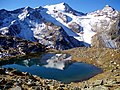 | Wilder Freiger | 3418 | NT/ST | Stubai Alps | 46°58′13″N11°11′26″E / 46.97028°N 11.19056°E | 2.0 Wilder Pfaff | 282 Pfaffennieder | 1865 |
| 43 |  | Östliche Seespitze | 3416 | NT | Stubai Alps | 47°02′57″N11°09′06″E / 47.04917°N 11.15167°E | 1.2 Ruderhofspitze | 185 Hochmoosscharte | 1863 |
| 44 |  | Schrammacher | 3411 | NT | Zillertal Alps Tuxer Kamm | 47°01′37″N11°38′35″E / 47.02694°N 11.64306°E | 3.1 Olperer | 452 Alpeiner Scharte | 1847 |
| 45 | Weißer Kogel | 3409 | NT | Ötztal Alps Weißkamm | 46°53′30″N10°54′22″E / 46.89167°N 10.90611°E | 2.1 Wildspitze | 199 Taufkarjoch | 1862 | |
| 46 |  | Talleitspitze | 3406 | NT | Ötztal Alps Maine Ridge | 46°49′59″N10°53′11″E / 46.83306°N 10.88639°E | 2.2 Kreuzspitze | 186 | 1811 |
| 47 |  | Hochfirst | 3403 | NT/ST | Ötztal Alps Maine Ridge | 46°49′36″N11°04′51″E / 46.82667°N 11.08083°E | 3.9 Hinterer Seelenkogel | 393 NE of Scheiberkogel | 1870 |
| 48 |  | Daberspitze | 3402 | ET | Venediger Group Hohe Tauern | 47°00′59″N12°12′25″E / 47.01639°N 12.20694°E | 1.0 Rötspitze | 222 Welitzscharte | 1873 |
| 49 |  | Sennkogel | 3400 | NT | Ötztal Alps Maine Ridge | 46°48′18″N10°51′21″E / 46.80500°N 10.85583°E | 1.6 Kreuzspitze | 164 Saykogeljoch | 1871 |
| 50 |  | Fluchthorn | 3399 | NT | Silvretta | 46°53′27″N10°13′39″E / 46.89083°N 10.22750°E | 15.2 Piz Linard | 647 Fuorcla Zadrell | 1861 |
| 51 |  | Liebenerspitze | 3399 | NT/ST | Ötztal Alps Maine Ridge | 46°49′13″N11°04′32″E / 46.82028°N 11.07556°E | 0.8 Hochfirst | 166 Gaisbergjoch | 1872 |
| 52 |  | Großer Bärenkopf | 3396 | Sb | Glockner Group Hohe Tauern | 47°07′51″N12°43′54″E / 47.13083°N 12.73167°E | 1.8 Klockerin | 302 Riffltor | 1869 |
| 53 |  | Hohe Geige | 3395 | NT | Ötztal Alps Geigenkamm | 47°00′17″N10°54′31″E / 47.00472°N 10.90861°E | 7.9 Verpeilspitze | 458 Nördliches Pollesjoch | 1853 |
| 54 |  | Rostizkogel | 3394 | NT | Ötztal Alps Kaunergrat | 46°58′07″N10°47′41″E / 46.96861°N 10.79472°E | 1.8 Watzespitze | 213 Seekarlesjoch ? | 1893 |
| 55 |  | Schrandele | 3393 | NT | Stubai Alps | 47°03′17″N11°06′42″E / 47.05472°N 11.11167°E | 1.3 Schrankogel | 168 P. 3225 | 1868 [6] |
| 56 |  | Rötenspitze | 3393 | NT/ST | Ötztal Alps Maine Ridge | 46°46′30″N10°56′40″E / 46.77500°N 10.94444°E | 1.3 Hintere Schwärze | 156 Pfasser Scharte | 1892 |
| 57 |  | Großer Löffler | 3379 | NT/ST | Zillertal Alps Main ridge | 47°01′57″N11°54′57″E / 47.03250°N 11.91583°E | 9.4 Turnerkamp | 368 Trattenjoch | 1843 |
| 58 |  | Östliche Schwarzenbergspitze | 3379 | NT | Stubai Alps | 47°01′52″N11°07′14″E / 47.03111°N 11.12056°E | 1.9 Ruderhofspitze | 206 Hölltalscharte | 1888 |
| 59 |  | Schwabenkopf | 3379 | NT | Ötztal Alps Kaunergrat | 47°00′23″N10°47′38″E / 47.00639°N 10.79389°E | 0.9 Verpeilspitze | 183 Schwabenjoch | 1892 |
| 60 |  | Eiskastenspitze | 3373 | NT | Ötztal Alps Kaunergrat | 46°55′49″N10°47′30″E / 46.93028°N 10.79167°E | 1.3 Bliggspitze | 203 Bliggjoch | 1853 |
| 61 |  | Vorderer Diemkogel | 3372 | NT | Ötztal Alps Maine Ridge | 46°48′40″N10°55′22″E / 46.81111°N 10.92278°E | 1.9 Hintere Diemkogel | 150 | 1853 [6] |
| 62 |  | Hoher Eichham | 3371 | ET | Venediger Group Hohe Tauern | 47°03′13″N12°24′23″E / 47.05361°N 12.40639°E | 5 Hoher Zaun | 329 Seekopfscharte | 1887 |
| 63 |  | Schwarzenstein | 3369 | NT/ST | Zillertal Alps Main ridge | 47°00′36″N11°52′27″E / 47.01000°N 11.87417°E | 4.1 Großer Löffler | 342 Floitenjoch | 1852 |
| 64 | | Hoher Tenn | 3368 | Sb | Glockner Group Hohe Tauern | 47°10′47″N12°45′34″E / 47.17972°N 12.75944°E | 2.1 Gross Wiesbachhorn | 337 Wiesbachscharte | 1840 [6] |
| 65 |  | Malhamspitzen | 3368 | ET | Venediger Group Hohe Tauern | 47°02′57″N12°15′34″E / 47.04917°N 12.25944°E | 1.7 Hint. Gubachspitze | 321 Reggentorl | 1873 |
| 66 |  | Innere Schwarze Schneid | 3367 | NT | Ötztal Alps Weißkamm | 46°55′27″N10°55′17″E / 46.92417°N 10.92139°E | 3.7 Weißer Kogel | 293 P. 3074 | 1876 |
| 67 |  | Hochalmspitze | 3360 | Ca | Ankogel Group Hohe Tauern | 47°00′54″N13°19′16″E / 47.01500°N 13.32111°E | 45.6 Großes Wiesbachhorn | 946 Niederer Tauern | 1855 |
| 68 |  | Großer Geiger | 3360 | ET/Sb | Venediger Group Hohe Tauern | 47°05′35″N12°18′32″E / 47.09306°N 12.30889°E | 2.8 Großvenediger | 293 East of Maurertörl | 1871 |
| 69 |  | Wilde Leck | 3359 | NT | Stubai Alps | 47°00′10″N11°03′45″E / 47.00278°N 11.06250°E | 5.2 Schrankogel | 309 Fernaujoch | 1865 [6] |
| 70 |  | Mittlerer Bärenkopf | 3358 | Ca/Sb | Glockner Group Hohe Tauern | 47°07′38″N12°42′48″E / 47.12722°N 12.71333°E | 1.4 Großer Bärenkopf | 171 Keilscharte | 1871 |
 | Seekogel | 3358 | NT | Ötztal Alps Kaunergrat | 46°58′18″N10°48′39″E / 46.97167°N 10.81083°E | 1.2 Rostizkogel | 134 P. 3224 | 1899 | |
| 71 |  | Glockturm | 3355 | NT | Ötztal Alps Glockturmkamm | 46°53′36″N10°39′56″E / 46.89333°N 10.66556°E | 6.2 Weißseespitze | 415 Weißseejoch | 1853 |
| 72 |  | Rofelewand | 3354 | NT | Ötztal Alps Kaunergrat | 47°01′57″N10°49′06″E / 47.03250°N 10.81833°E | 3.4 Verpeilspitze | 529 Verpeiljoch | 1873 |
 | Aperer Pfaff | 3353 | NT | Stubai Alps | 46°58′20″N11°08′27″E / 46.97222°N 11.14083°E | 0.7 Zuckerhütl | 145 Pfaffenjoch | 1867 | |
| 73 |  | Windacher Daunkogel | 3348 | NT | Stubai Alps | 46°59′15″N11°04′52″E / 46.98750°N 11.08111°E | 2.2 Wilde Leck | 245 Wütenkarsattel | 1876 |
| 74 |  | Warenkarseitenspitze | 3347 | NT | Stubai Alps | 46°58′48″N11°04′34″E / 46.98000°N 11.07611°E | 0.9 Windacher Daunkogel | 161 Warenkarscharte | 1890 |
| 75 |  | Puitkogel | 3345 | NT | Ötztal Alps Geigenkamm | 46°58′53″N10°54′05″E / 46.98139°N 10.90139°E | 2.6 Hohe Geige | 392 Weißmaurachjoch | 1894 [9] |
| 76 |  | Stubaier Wildspitze | 3341 | NT | Stubai Alps | 46°58′59″N11°05′58″E / 46.98306°N 11.09944°E | 1.5 Windacher Daunkogel | 168 NW of Wildspitze | 1882 |
| 77 |  | Schaufelspitze | 3332 | NT | Stubai Alps | 46°58′42″N11°06′57″E / 46.97833°N 11.11583°E | 1.3 Stubaier Wildspitze | 216 Bildstöckljoch | 1862 |
| 78 |  | Fuscherkarkopf | 3331 | Ca/Sb | Glockner Group Hohe Tauern | 47°05′56″N12°44′44″E / 47.09889°N 12.74556°E | 3.5 Hohe Dock | 490 Fuscherkarscharte | 1845 [6] |
| 79 |  | Löcherkogel | 3324 | NT | Ötztal Alps Kaunergrat | 46°57′33″N10°47′29″E / 46.95917°N 10.79139°E | 1.0 Rostizkogel | 243 Rostizjoch | 1900 |
| 80 | | Granatenkogel | 3318 | NT/ST | Ötztal Alps Maine Ridge | 46°50′13″N11°04′20″E / 46.83694°N 11.07222°E | 1.2 Hochfirst | 158 Hochfirstjoch | 1891 |
| 81 |  | Großer Hexenkopf | 3313 | ET | Venediger Group Hohe Tauern | 47°03′34″N12°24′20″E / 47.05944°N 12.40556°E | 0.6 Hoher Eichham | 188 Nördl. Eichhamscharte | 1898 |
| 82 |  | Piz Buin | 3312 | Vb/Gb | Silvretta | 46°50′39″N10°07′07″E / 46.84417°N 10.11861°E | 6.1 Piz Linard | 544 Futschölpass | 1865 |
| 83 |  | Vorderer Brunnenkogel | 3306 | NT | Stubai Alps | 47°04′59″N11°06′19″E / 47.08306°N 11.10528°E | 1.0 Hinterer Brunnenkogel | 181 P. 3125 | 1895 |
| 84 |  | Reichenspitze | 3303 | Sb/NT | Zillertal Alps Eastern group | 47°08′22″N12°06′39″E / 47.13944°N 12.11083°E | 12.6 Dreiherrnspitze | 683 Schüttaler Joch | 1856 |
| 85 |  | Weißspitze | 3300 | ET | Venediger Group Hohe Tauern | 47°04′34″N12°23′33″E / 47.07611°N 12.39250°E | 1.9 Kristallwand | 190 Frosnitztörl | 1881 |
| 86 |  | Lüsener Fernerkogel | 3298 | NT | Stubai Alps | 47°05′48″N11°06′54″E / 47.09667°N 11.11500°E | 1.7 Vorderer Brunnenkogel | 163 N of Lüsener Spitze | 1836 |
| 87 |  | Strahlkogel | 3295 | NT | Stubai Alps | 47°06′33″N11°01′10″E / 47.10917°N 11.01944°E | 7.1 Vorderer Brunnenkogel | 513 Winnebachjoch | 1833 |
| 88 | | Hintere Ölgrubenspitze | 3295 | NT | Ötztal Alps Kaunergrat | 46°53′27″N10°46′30″E / 46.89083°N 10.77500°E | 1.1 Sexegertenspitze | 185 Wannetjoch | 1871 |
| 89 |  | Keeskogel | 3291 | Sb | Venediger Group Hohe Tauern | 47°08′11″N12°18′43″E / 47.13639°N 12.31194°E | 3.2 Großvenediger | 374 Zwischensulzbachtörl | 1840 [6] |
| 90 |  | Schlieferspitze | 3290 | Sb | Venediger Group Hohe Tauern | 47°07′22″N12°14′36″E / 47.12278°N 12.24333°E | 4.6 Hint. Maurerkeeskopf | 514 Krimmler Törl | 1871 |
| 91 |  | Hohe Wand | 3289 | NT/ST | Zillertal Alps Tuxer Kamm | 47°00′48″N11°37′39″E / 47.01333°N 11.62750°E | 1.9 Schrammacher | 154 E of Sagwandspitze | 1883 |
| 92 |  | Gefrorene-Wand-Spitzen | 3288 | NT | Zillertal Alps Tuxer Kamm | 47°03′53″N11°40′44″E / 47.06472°N 11.67889°E | 2.0 Olperer | 253 Riepensattel | 1867 |
| 93 |  | Breiter Grießkogel | 3287 | NT | Stubai Alps | 47°06′04″N11°01′22″E / 47.10111°N 11.02278°E | 0.9 Strahlkogel | 157 | 1881 [9] |
| 94 |  | Großer Mörchner | 3285 | NT | Zillertal Alps Main ridge | 47°01′52″N11°51′56″E / 47.03111°N 11.86556°E | 2.4 Schwarzenstein | 154 Schwarzensteinsattel | 1846 |
| 95 |  | Petzeck | 3283 | Ca | Schober Group Hohe Tauern | 46°56′53″N12°48′17″E / 46.94806°N 12.80472°E | 14.9 Hohenwartkopf | 799 Peischlachtörl | 1844 [9] |
| 96 |  | Roter Knopf | 3281 | Ca/ET | Schober Group Hohe Tauern | 46°58′43″N12°44′22″E / 46.97861°N 12.73944°E | 6 Petzeck | 549 Gößnitzscharte | 1872 |
 | Wildgerlosspitze | 3280 | Sb/NT | Zillertal Alps Eastern group | 47°08′37″N12°05′54″E / 47.14361°N 12.09833°E | 1.1 Reichenspitze | 145 W and E of Hahnenkamm | 1877 | |
| 97 | Im Hinteren Eis | 3279 | NT | Ötztal Alps Maine Ridge | 46°47′48″N10°47′23″E / 46.79667°N 10.78972°E | 2.8 Langtauferer Spitze | 154 W of Teufelsegg | Early | |
| 98 |  | Stockkogel / Zirmkogel | 3278 | NT | Ötztal Alps Maine Ridge | 46°52′53″N10°59′20″E / 46.88139°N 10.98889°E | 1.3 Gampleskogel | 153 | 1893 |
| 99 |  | Habicht | 3277 | NT | Stubai Alps | 47°02′37″N11°17′23″E / 47.04361°N 11.28972°E | 10.1 Östliche Seespitze | 527 Simmingjöchl | 1836 [9] |
| 100 | | Gsallkopf | 3277 | NT | Ötztal Alps Kaunergrat | 47°02′16″N10°48′18″E / 47.03778°N 10.80500°E | 1.2 Rofelewand | 287 Rofelejoch | 1894 |
| 101 |  | Feuerstein | 3268 | NT/ST | Stubai Alps | 46°58′18″N11°14′40″E / 46.97167°N 11.24444°E | 3.6 Wilder Freiger | 428 Weites Türl | 1854 [9] |
| 102 |  | Äussere Schwarze Schneid | 3257 | NT | Ötztal Alps Weißkamm | 46°56′15″N10°57′10″E / 46.93750°N 10.95278°E | 2.2 Innere Schwarze Schneid | 201 Seiter Jöchl | 1853 [9] |
| 103 |  | Piz Buin Pitschen | 3255 | Vb/Gb | Silvretta | 46°50′32″N10°06′42″E / 46.84222°N 10.11167°E | 0.5 Piz Buin | 199 Buinlücke | 1868 |
| 104 |  | Hocharn | 3254 | Ca/Sb | Goldberg Group Hohe Tauern | 47°04′34″N12°56′14″E / 47.07611°N 12.93722°E | 13.9 Sinwelleck | 678 Hochtor | 1827 [9] |
| 105 |  | Berliner Spitze / III. Hornspitze | 3253 | NT | Zillertal Alps Main ridge | 47°00′09″N11°50′42″E / 47.00250°N 11.84500°E | 3.0 Turnerkamp | 233 Schwarzenbachscharte | 1874 |
| 106 |  | Ankogel | 3252 | Ca/Sb | Ankogel Group Hohe Tauern | 47°03′04″N13°14′57″E / 47.05111°N 13.24917°E | 6.4 Hochalm Spitze | 578 Großelendscharte | 1762 |
| 107 |  | Wassertalkogel | 3252 | NT | Ötztal Alps Geigenkamm | 46°58′01″N10°54′19″E / 46.96694°N 10.90528°E | 1.5 Puitkogel | 172 | 1895 [9] |
| 108 |  | Rauhkofel | 3251 | NT/ST | Zillertal Alps Eastern group | 47°04′34″N12°05′31″E / 47.07611°N 12.09194°E | 7.2 Reichenspitze | 593 Heiliges Geistjöchl | 1853 |
| 109 |  | Großer Hornkopf | 3251 | Ca | Schober Group Hohe Tauern | 46°58′02″N12°46′44″E / 46.96722°N 12.77889°E | 2.8 Petzeck | 455 Nd. Gradenscharte | 1890 |
| 110 |  | Quirl | 3251 | ET | Venediger Group Hohe Tauern | 47°01′59″N12°16′08″E / 47.03306°N 12.26889°E | 1.5 Malhamspitzen | 166 Steingrubenscharte | 1887 |
| 111 |  | Hohe Fürleg | 3244 | ET/Sb | Venediger Group Hohe Tauern | 47°08′30″N12°21′46″E / 47.14167°N 12.36278°E | 2.9 Kleinvenediger | 410 Untersulzbachtörl | 1894 |
| 112 |  | Silvrettahorn | 3244 | Vb/Gb | Silvretta | 46°51′29″N10°05′33.5″E / 46.85806°N 10.092639°E | 2.3 Piz Buin Pitschen | 201 Fuorcla dal Cunfin | 1865 |
| 113 |  | Hochschober | 3242 | ET | Schober Group Hohe Tauern | 46°56′33″N12°41′54″E / 46.94250°N 12.69833°E | 5 Roter Knopf | 433 Kaisertörl | 1852 |
| 114 |  | Lenkstein | 3236 | ET/ST | Rieserferner Group Hohe Tauern | 46°56′21″N12°10′01″E / 46.93917°N 12.16694°E | 3.0 Hochgall | 152 Lenksteinjoch | 1874 |
| 115 |  | Hoher Seeblaskogel | 3235 | NT | Stubai Alps | 47°05′44″N11°04′29″E / 47.09556°N 11.07472°E | 2.7 Vorderer Brunnenkogel | 365 N of Bachfallenkopf | 1881 |
| 116 |  | Großer Muntanitz | 3232 | ET | Granatspitz Group Hohe Tauern | 47°04′25″N12°35′21″E / 47.07361°N 12.58917°E | 7.3 Grossglockner | 717 Kalser Tauern | 1871 |
| 117 |  | Hoher Riffler | 3231 | NT | Zillertal Alps Tuxer Kamm | 47°04′52″N11°42′16″E / 47.08111°N 11.70444°E | 2.6 Gefrorene-Wand-Spitzen | 321 Friesenbergscharte | 1853 [6] |
| 118 | | Mörchenschneide | 3230 | NT | Zillertal Alps Main ridge | 47°02′04″N11°51′40″E / 47.03444°N 11.86111°E | 0.5 Großer Mörchner | 155 Mörchenschneidscharte | 1892 |
| 119 |  | Augstenberg | 3228 | NT/Gb | Silvretta | 46°51′53″N10°12′14″E / 46.86472°N 10.20389°E | 3.2 Fluchthorn | 430 Vermuntpass | 1881 |
| 120 |  | Hintere Stangenspitze | 3225 | NT | Zillertal Alps Main ridge | 47°03′26″N11°58′34″E / 47.05722°N 11.97611°E | 5.3 Großer Löffler | 465 Frankbachjoch | 1891 [9] |
| 121 |  | Hinterer Daunkopf | 3225 | NT | Stubai Alps | 47°00′15″N11°05′47″E / 47.00417°N 11.09639°E | 1.6 Westliche Daunkogel | 168 Daunjoch | 1887 |
| 122 |  | Längentaler Weißer Kogel | 3218 | NT | Stubai Alps | 47°04′12″N11°05′09″E / 47.07000°N 11.08583°E | 1.3 Hinterer Brunnenkogel | 230 Längentaljoch | 1888 |
| 123 |  | Gaißlehnkogel | 3216 | NT | Stubai Alps | 47°03′48″N11°04′35″E / 47.06333°N 11.07639°E | 1.1 Längentaler Weißer Kogel | 164 Gaislehnscharte | 1888 |
| 124 |  | Signalhorn | 3210 | Vb/Gb | Silvretta | 46°50′54″N10°05′50″E / 46.84833°N 10.09722°E | 1.1 Silvrettahorn | 163 Egghornlücke | 1865 |
| 125 |  | Wollbachspitze | 3210 | NT/ST | Zillertal Alps Main ridge | 47°03′00″N11°58′47″E / 47.05000°N 11.97972°E | 0.8 Hintere Stangenspitze | 155 Stangenjoch | 1852 |
| 126 |  | Hocheiser | 3206 | Sb | Glockner Group Hohe Tauern | 47°09′23″N12°40′24″E / 47.15639°N 12.67333°E | 3.5 Hohe Riffl | 567 Kapruner Törl | 1871 |
| 127 |  | Glödis | 3206 | ET | Schober Group Hohe Tauern | 46°57′40″N12°43′34″E / 46.96111°N 12.72611°E | 1.9 Roter Knopf | 376 Glödistörl | 1872 |
| 128 |  | Kitzsteinhorn | 3203 | Sb | Glockner Group Hohe Tauern | 47°11′17″N12°41′15″E / 47.18806°N 12.68750°E | 3.7 Hocheiser | 436 Geralscharte | 1828 |
 | Schattenspitze | 3202 | Vb | Silvretta | 46°52′03″N10°05′14″E / 46.86750°N 10.08722°E | 0.4 Schneeglocke | 145 Schattenlücke | 1914 | |
| 129 |  | Großer Greiner | 3201 | NT | Zillertal Alps Main ridge | 47°01′11″N11°45′14″E / 47.01972°N 11.75389°E | 3.7 Großer Möseler | 190 S of Gr. Greiner | 1873 |
| 130 |  | Zopetspitze | 3198 | ET | Venediger Group Hohe Tauern | 47°03′26″N12°21′42″E / 47.05722°N 12.36167°E | 2.9 Großer Hexenkopf | 216 Scheidlscharte | 1898 |
| 131 |  | Dreiländerspitze | 3197 | NT/Vb/Gb | Silvretta | 46°51′04″N10°08′42″E / 46.85111°N 10.14500°E | 2.0 Piz Buin | 300 Urezzasjoch | 1853 [6] |
| 132 |  | Pitztaler Urkund | 3197 | NT | Ötztal Alps Weißkamm | 46°53′43″N10°48′34″E / 46.89528°N 10.80944°E | 0.7 Hochvernagtwand | 164 Urkundsattel | Early ? |
| 133 | Kühlehnkarschneid | 3195 | NT | Stubai Alps | 47°04′08″N11°03′58″E / 47.06889°N 11.06611°E | 1.0 Geißlehnkg | 185 | 1888 | |
| 134 | 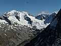 | Westliche Floitenspitze | 3195 | NT/ST | Zillertal Alps Main ridge | 47°01′13″N11°53′42″E / 47.02028°N 11.89500°E | 1.1 Schwarzenstein | 168 Flojtenjoch | 1876 |
| 135 |  | Großer Löffler / Löffelspitze | 3190 | ET | Venediger Group Hohe Tauern | 47°01′03″N12°09′52″E / 47.01750°N 12.16444°E | 2.9 Rötspitze | 303 Rotenmannjoch | 1877 |
| 136 |  | Gleirscher Fernerkogel | 3189 | NT | Stubai Alps | 47°06′50″N11°03′50″E / 47.11389°N 11.06389°E | 3.2 Breiter Grießkogel | 321 Zwieselbachjoch | 1883 |
| 137 | Krone | 3188 | NT/Gb | Silvretta | 46°52′32″N10°13′55″E / 46.87556°N 10.23194°E | 1.5 Fluchthorn | 243 Zahnjoch | 1849 | |
| 138 |  | Talggenköpfe | 3179 | NT | Zillertal Alps Main ridge | 47°00′48″N11°45′45″E / 47.01333°N 11.76250°E | 1.0 Großer Greiner | 150 | 1885 |
| 139 |  | Keeseck / Keesegg | 3173 | ET | Venediger Group Hohe Tauern | 46°58′09″N12°14′28″E / 46.96917°N 12.24111°E | 5.4 Daberspitze | 275 S of Schwarzachtörl | 1894 |
| 140 | 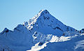 | Grubenwand | 3173 | NT | Stubai Alps | 47°07′05″N11°05′07″E / 47.11806°N 11.08528°E | 1.7 Gleirscher Fernerkogel | 225 | 1894 |
 | Larstigspitze | 3172 | NT | Stubai Alps | 47°06′32″N11°02′01″E / 47.10889°N 11.03361°E | 0.7 Strahlkogel | 140 Larstigscharte | 1881 | |
| 141 | Plattigkopf | 3170 | NT | Ötztal Alps Glockturmkamm | 46°55′39″N10°40′33″E / 46.92750°N 10.67583°E | 3.0 Rifflkarspitze | 230 Kaiserjoch | 1903 | |
| 142 | Kleinspitze | 3169 | NT | Zillertal Alps Eastern group | 47°05′18″N12°04′49″E / 47.08833°N 12.08028°E | 1.5 Rauchkofel | 175 | 1890 | |
| 143 |  | Hoher Riffler | 3168 | NT | Verwall Alps | 47°06′57″N10°22′15″E / 47.11583°N 10.37083°E | 23.8 Muttler | 1,341 Zeinisjoch | 1864 |
| 144 |  | Jagdhausspitze | 3165 | ET | Venediger Group Hohe Tauern | 47°00′33″N12°09′48″E / 47.00917°N 12.16333°E | 0.9 Löffelspitze | 195 | 1894 |
| 145 | | Klammerköpfe | 3163 | Ca | Schober Group Hohe Tauern | 46°57′32″N12°45′44″E / 46.95889°N 12.76222°E | 1.3 Hornkopf | 233 Klammerscharte | ? |
| 146 |  | Nederkogel/Nörderkogel | 3163 | NT | Ötztal Alps Maine Ridge | 46°54′25″N11°00′33″E / 46.90694°N 11.00917°E | 1.4 Zirmkogel | 231 Seiter Schartle | 1853 |
| 147 |  | Hohe Achsel | 3161 | ET | Venediger Group Hohe Tauern | 47°04′02″N12°25′36″E / 47.06722°N 12.42667°E | 1.4 Hintere Seekopf | 150 | 1905 |
| 148 |  | Hohes Kreuz | 3159 | ET | Venediger Group Hohe Tauern | 47°00′27″N12°13′31″E / 47.00750°N 12.22528°E | 1.5 Daberspitze | 165 SE of Tredeberscharte | 1904 |
| 149 | Roßwandspitze | 3157 | NT | Zillertal Alps Main ridge | 47°04′59″N11°57′36″E / 47.08306°N 11.96000°E | 2.8 Hintere Stangenspitze | 210 | 1852 | |
| 150 | Fleischbachspitze | 3157 | ET | Rieserferner Group Hohe Tauern | 46°57′29″N12°09′45″E / 46.95806°N 12.16250°E | 0.9 Muklaspitze | 204 Fleischbachjoch | 1876 | |
| 151 |  | Vordere Sonnenwand | 3156 | NT | Stubai Alps | 47°07′46″N11°03′42″E / 47.12944°N 11.06167°E | 1.7 Gleirscher Fernerkogel | 150 | 1894 |
| 152 |  | Kreuzspitze | 3155 | ET | Venediger Group Hohe Tauern | 47°02′48″N12°21′34″E / 47.04667°N 12.35944°E | 1.2 Zopetspitze | 211 P. 2944 | Early |
| 153 | | Murkarspitze | 3150 | NT | Stubai Alps | 47°01′26″N11°02′09″E / 47.02389°N 11.03583°E | 1.9 Kuhscheibe | 205 | 1887 |
| 154 |  | Alplesspitze | 3149 | ET | Venediger Group Hohe Tauern | 46°57′28″N12°15′39″E / 46.95778°N 12.26083°E | 1.9 Keesegg | 258 Panargenscharte | 1896 |