Sayres Benchmark | |
---|---|
Highest point | |
Elevation | 13,746 ft (4,190 m) [1] |
Prominence | 968 ft (295 m) [1] |
Parent peak | La Plata Peak (14,343 ft) [1] |
Isolation | 1.92 mi (3.09 km) [1] |
Coordinates | 39°00′34″N106°29′52″W / 39.009374°N 106.497738°W [2] |
Geography | |
Country | United States |
State | Colorado |
County | Chaffee |
Protected area | Collegiate Peaks Wilderness |
Parent range | Rocky Mountains Sawatch Range Collegiate Peaks [2] |
Topo map | USGS Mount Elbert |
Climbing | |
Easiest route | class 2 hiking [1] |
Sayres Benchmark is a 13,746-foot-elevation (4,190-meter) mountain summit in Chaffee County, Colorado, United States.
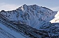
Sayres Benchmark is located three miles (4.8 km) east of the Continental Divide in the Collegiate Peaks which are a subset of the Sawatch Range. The mountain is set on the boundary of the Collegiate Peaks Wilderness on land managed by San Isabel National Forest. [1] The highest peak in Colorado and the Rocky Mountains, Mount Elbert, is 7.46 miles (12.01 km) north-northeast of Sayres Benchmark, and the fifth-highest, La Plata Peak, is less than two miles to the northeast. [2] Sayres ranks as the 130th-highest summit in Colorado. [1] Precipitation runoff from the mountain's south slope drains into Clear Creek, whereas the north slope drains to Lake Creek, and both are tributaries of the Arkansas River. Topographic relief is significant as the summit rises 2,950 feet (899 m) above North Fork Clear Creek in 1.5 miles (2.4 km). An ascent of Sayres involves 10 miles of hiking with 3,500-feet of elevation gain. [3] In winter the peak offers excellent ski mountaineering on its rugged north face. [4]
According to the Köppen climate classification system, Sayres Benchmark is located in an alpine subarctic climate zone with cold, snowy winters, and cool to warm summers. [5] Due to its elevation, it receives precipitation all year, as snow in winter and as thunderstorms in summer, with a dry period in late spring. Climbers can expect afternoon rain, hail, and lightning from the seasonal monsoon in late July and August.
Powell Peak is a summit in Grand County, Colorado, in the United States. With an elevation of 13,176 feet (4,016 m), Powell Peak is the 493rd-highest summit in the state of Colorado.
Palmyra Peak is a 13,319-foot-elevation (4,060-meter) mountain summit located in San Miguel County of southwest Colorado, United States. It is situated four miles south of the town of Telluride, on land managed by Uncompahgre National Forest. It is part of the San Juan Mountains which are a subset of the Rocky Mountains, and is west of the Continental Divide. It is immediately south of Telluride Ski Resort, from which it is a prominent landmark, and Palmyra has the distinction of having the highest inbounds skiing terrain of any North American ski resort. Topographic relief is significant as the north aspect rises 2,300 feet above Prospect Basin in one mile, and the west aspect rises 2,100 feet above Alta Lakes in one-half mile. The mountain's name has been officially adopted by the United States Board on Geographic Names in association with the Palmyra Mine, a gold and silver mine located at an elevation of 11,650-feet on the peak's western aspect. Other mines on its flanks included Lakeview Mine, Mountain Quail Mine, Roy Johnston mine, and Turkey Creek Mine.
North Star Mountain is a 13,614-foot (4,150 m) mountain summit on the shared border of Park County and Summit County, in Colorado, United States.
Mount White is a 13,667-foot (4,166 m) mountain summit in Chaffee County, Colorado, United States.
Apache Peak is a 13,441-foot (4,097 m) mountain summit on the boundary shared by Boulder County and Grand County, in Colorado, United States.
Navajo Peak is a 13,409-foot (4,087 m) mountain summit on the boundary shared by Boulder County and Grand County, in Colorado, United States.
Mount Tweto is a 13,672-foot (4,167 m) mountain summit on the boundary shared by Lake County and Park County, in Colorado, United States.
Carson Peak is a 13,662-foot-elevation (4,164-meter) summit in Hinsdale County, Colorado, United States.
Paiute Peak is a 13,088-foot (3,989 m) mountain summit on the boundary shared by Boulder County and Grand County, in Colorado, United States.
Mount Moss is a 13,192-foot-elevation (4,021-meter) mountain summit on the common boundary shared by La Plata County and Montezuma County in Colorado.
Electric Peak is a 13,598-foot (4,145 m) mountain summit on the boundary shared by Custer and Saguache counties, in Colorado, United States.
Turner Peak is a 13,233-foot-elevation (4,033-meter) mountain summit in Chaffee County, Colorado, United States.
Jones Mountain is a 13,218-foot-elevation (4,029-meter) mountain summit in Chaffee County, Colorado, United States.
Emma Burr Mountain is a 13,544-foot-elevation (4,128-meter) mountain summit on the common border shared by Chaffee and Gunnison counties in Colorado, United States.
Grizzly Peak is a 13,309-foot-elevation (4,057-meter) mountain summit in Gunnison County, Colorado, United States.
Mount Sheridan is a 13,748-foot (4,190 m) mountain summit on the boundary shared by Lake County and Park County, in Colorado, United States.
Rinker Peak is a 13,789-foot (4,203 m) mountain summit in Chaffee County, Colorado, United States.
Twin Peaks is a 13,341-foot (4,066 m) mountain summit in Chaffee County, Colorado, United States.
Ervin Peak is a 13,538-foot (4,126 m) mountain summit in Chaffee County, Colorado, United States.
Quail Mountain is a 13,465-foot (4,104 m) mountain summit in Chaffee County, Colorado, United States.