South Hill, Virginia | |
---|---|
Coordinates: 36°43′36″N78°7′50″W / 36.72667°N 78.13056°W | |
Country | United States |
State | Virginia |
County | Mecklenburg |
Area | |
• Total | 6.85 sq mi (25.52 km2) |
• Land | 6.82 sq mi (25.45 km2) |
• Water | 0.03 sq mi (0.07 km2) |
Elevation | 436 ft (133 m) |
Population (2020) | |
• Total | 4,709 |
• Estimate (2019) [3] | 4,456 |
• Density | 442.65/sq mi (170.90/km2) |
Time zone | UTC−5 (Eastern (EST)) |
• Summer (DST) | UTC−4 (EDT) |
ZIP code | 23970 |
Area code | 434 |
FIPS code | 51-73904 [4] |
GNIS feature ID | 2391422 [2] |
Website | http://www.southhillva.org/ |
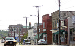
South Hill is a town in Mecklenburg County, Virginia, United States. The population was 4,709 at the 2020 census. Located on major Interstate and U.S. highways, it has a full-service hospital (serving patients from several rural counties), a tobacco market, and several hotels. South Hill has a close relationship with the neighboring town of La Crosse. Kerr Reservoir, a large reservoir popular with boaters and fishermen, is a short distance to the southwest.
The Colonial Theatre was listed on the National Register of Historic Places in 2003. [5]
South Hill is located at 36°43′36″N78°7′50″W / 36.72667°N 78.13056°W (36.726759, −78.130597). [6]
The town has a total area of 6.31 square miles (16.4 km2), of which 6.27 square miles (16.4 km2) is land and 0.04 square mile (0.1 km2) (0.47%) is water.
Census | Pop. | Note | %± |
---|---|---|---|
1910 | 732 | — | |
1920 | 1,074 | 46.7% | |
1930 | 1,405 | 30.8% | |
1940 | 1,739 | 23.8% | |
1950 | 2,153 | 23.8% | |
1960 | 2,569 | 19.3% | |
1970 | 3,858 | 50.2% | |
1980 | 4,347 | 12.7% | |
1990 | 4,217 | −3.0% | |
2000 | 4,403 | 4.4% | |
2010 | 4,650 | 5.6% | |
2019 (est.) | 4,456 | [3] | −4.2% |
U.S. Decennial Census [7] |
As of the census [4] of 2000, there were 4,403 people, 1,809 households, and 1,190 families living in the town. The population density was 696.2 people per square mile (269.0/km2). There were 1,988 housing units at an average density of 314.4/sq mi (121.5/km2). The racial makeup of the town was 58.37% White, 39.43% African American, 0.30% Native American, 1.00% Asian, 0.39% from other races, and 0.52% from two or more races. Hispanic or Latino of any race were 1.57% of the population.
There were 1,809 households, out of which 27.8% had children under the age of 18 living with them, 43.7% were married couples living together, 18.6% had a female householder with no husband present, and 34.2% were non-families. 30.0% of all households were made up of individuals, and 13.8% had someone living alone who was 65 years of age or older. The average household size was 2.33 and the average family size was 2.88.
In the town the population was spread out, with 23.2% under the age of 18, 7.6% from 18 to 24, 26.3% from 25 to 44, 23.0% from 45 to 64, and 19.9% who were 65 years of age or older. The median age was 40 years. For every 100 females, there were 77.6 males. For every 100 females aged 18 and over, there were 70.5 males.
The median income for a household in the town was $31,078, and the median income for a family was $38,156. Males had a median income of $30,128 versus $21,996 for females. The per capita income for the town was $19,319. About 14.3% of families and 18.8% of the population were below the poverty line, including 30.9% of those under age 18 and 11.2% of those age 65 or over.
2008 Presidential Candidates Contributions from South Hill, VA [8] | ||
---|---|---|
Candidate | Party | Total Contributions |
Obama, Barack | Dem | $62,311 |
McCain, John | Rep | $59,990 |
Paul, Ron | Rep | $39,257 |
Clinton, Hillary | Dem | $34,777 |
Huckabee, Mike | Rep | $23,650 |
Keyes, Alan | Rep | $550 |
In previous years, election returns have shown that South Hill citizens favored Republican candidates (more often at 60% or above) in state and national elections since 1996, though this slipped to only 57.5% support for Republican candidate Mitt Romney in the 2012 Presidential election. [9]
In the 2006 election cycle, while donations from residents to Democratic and Republican candidates and organizations were almost evenly divided, citizens favored Republican candidate George Allen over Democratic candidate Jim Webb. [10] [11] Webb eventually went on to win the election.
In 2007–2008, contributions to presidential campaigns favored Republican candidates overall, although the top single recipient as of March was Democratic Senator Barack Obama. The 283 South Hill voters who participated in the state's February 12 Democratic primary also favored Obama over Senator Hillary Clinton, 58% to 41%; [12] the 244 Republican primary voters supported Senator John McCain (62.3%) over Governor Mike Huckabee (34.8%). [13]
South Hill is governed by a council/manager form of government, with an eight-member town council and a mayor.
Members of the South Hill Town Council:
Lillie Feggins-Boone (Ward 1)
Ashley C. Hardee (Ward 2)
Gavin Honeycutt (Ward 3)
Dr. Lisa Jordan (Ward 3)
Delores Luster (Ward 1)
Mike Moody (Ward 2)
Michael Smith (Ward 2)
Joseph E. Taylor, Jr. (Ward 3)
Mayor: Dean Marion Vice Mayor: Mike Moody
The daily operation of South Hill is overseen by a town manager, Keli Reekes.
The town council and mayor seats are non-partisan, and elections are held every four years.
Kane County is a county in the U.S. state of Utah. As of the 2020 United States Census, the population was 7,667. Its county seat and largest city is Kanab.
Crook County is a county in the northeastern corner of the U.S. state of Wyoming. As of the 2020 United States Census, the population was 7,181, making it the third-least populous county in Wyoming. Its county seat is Sundance. The county is located at the northwestern extreme of the Black Hills, which are its defining geographical feature.
Hardy County is a county in the U.S. state of West Virginia. As of the 2020 census, the population was 14,299. Its county seat is Moorefield. The county was created from Hampshire County in 1786 and named for Samuel Hardy, a distinguished Virginian.
Clallam County is a county in the U.S. state of Washington. As of the 2020 census, the population was 77,155, with an estimated population of 77,805 in 2022. The county seat and largest city is Port Angeles; the county as a whole comprises the Port Angeles, WA Micropolitan Statistical Area. The name is a Klallam word for "the strong people". The county was formed on April 26, 1854. Located on the Olympic Peninsula, it is south from the Strait of Juan de Fuca, which forms the Canada–US border, as British Columbia's Vancouver Island is across the strait.
Shenandoah County is a county located in the Commonwealth of Virginia. As of the 2020 United States Census, the population was 44,186. Its county seat is Woodstock. It is part of the Shenandoah Valley region of Virginia.
Halifax County is a county located in the Commonwealth of Virginia. As of the 2020 census, the population was 34,022. Its county seat is Halifax.
Brule County is a county in the U.S. state of South Dakota. As of the 2020 census, the population was 5,247. Its county seat is Chamberlain.
Barnwell County is a county in the U.S. state of South Carolina. As of the 2020 census, its population was 20,589. It is located in the Central Savannah River Area. Its county seat is Barnwell.
Bamberg County is a county located in the southwestern portion of U.S. state of South Carolina. As of the 2020 census, the population was 13,311, making the rural county the fourth-least populous of any in South Carolina. Its county seat is Bamberg.
Ward County is a county in the U.S. state of North Dakota. As of the 2020 census, the population was 69,919, making it the fourth-most populous county in North Dakota. Its county seat is Minot. Ward County is part of the Minot, ND Micropolitan Statistical Area.
Greene County is a county located in the U.S. state of North Carolina. As of the 2020 census, the population was 20,451. Its county seat is Snow Hill.
Red Willow County is a county located in the U.S. state of Nebraska. As of the 2020 United States Census, the population was 10,702. Its county seat is McCook.
Hooker County is a county in the U.S. state of Nebraska. As of the 2020 United States Census, the population was 711. Its county seat is Mullen, which is the county's only community of substantial size.
Musselshell County is a county in south-central Montana. As of the 2020 census, the population was 4,730. Its county seat is Roundup.
Golden Valley County is a county located in the U.S. state of Montana. As of the 2020 census, the population was 823, making it the third-least populous county in Montana. Its county seat is Ryegate.
Piscataquis County is a county located in the U.S. state of Maine. As of the 2020 census, its population was 16,800, making it Maine's least-populous county. Its county seat is Dover-Foxcroft. The county was incorporated on March 23, 1838, taken from the western part of Penobscot County and the eastern part of Somerset County. It is named for an Abenaki word meaning "branch of the river" or "at the river branch."
Trego County is a county located in the U.S. state of Kansas. Its county seat and largest city is WaKeeney. As of the 2020 census, the county population was 2,808. The county was named for Edgar Trego.
Worth County is a county located in the U.S. state of Iowa. As of the 2020 census, the population was 7,443. The county seat is Northwood. The county was founded in 1851 and named for Major General William Jenkins Worth (1794–1849), an officer in both the Seminole War and the Mexican–American War.
Eastford is a town in Windham County, Connecticut, United States. The town is part of the Northeastern Connecticut Planning Region. The population was 1,649 at the 2020 census.
West Greenwich is a town in Kent County, Rhode Island, United States. The population was 6,528 at the 2020 census. West Greenwich was named for the historic town of Greenwich, Kent, England. It was separated from East Greenwich in 1741. Students go to Exeter-West Greenwich Regional School in West Greenwich.