| The Castles | |
|---|---|
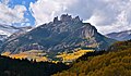
 Northeast aspect | |
| Highest point | |
| Elevation | 12,296 ft (3,748 m) [1] [2] |
| Prominence | 452 ft (138 m) [1] |
| Parent peak | West Elk Peak (13,042 ft) [1] |
| Isolation | 2.02 mi (3.25 km) [1] |
| Coordinates | 38°44′13″N107°10′07″W / 38.7369392°N 107.1686626°W [2] |
| Geography | |
 The Castles Location in Colorado  The Castles The Castles (the United States) | |
| Country | United States |
| State | Colorado |
| County | Gunnison County |
| Protected area | West Elk Wilderness |
| Parent range | Rocky Mountains West Elk Mountains |
| Topo map | USGS West Elk Peak |
| Geology | |
| Rock type | Stratified Breccia [3] |
| Climbing | |
| Easiest route | class 5.10 climbing [1] |
The Castles are naturally occurring pillars of stone in Gunnison County, Colorado, United States.