
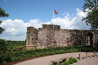
Ewenny Priory, in Ewenny in the Vale of Glamorgan, Wales, was a monastery of the Benedictine order, founded in the 12th century. The priory was unusual in having extensive military-style defences and in its state of preservation; the architectural historian John Newman described it as “the most complete and impressive Norman ecclesiastical building in Glamorgan”. Following the Dissolution of the Monasteries, parts of the priory were converted into a private house by Sir Edward Carne, a lawyer and diplomat. This Elizabethan house was demolished between 1803-1805 and replaced by a Georgian mansion, Ewenny Priory House. The house is still owned by the Turbervill family, descendants of Sir Edward. The priory is not open to the public apart from the Church of St Michael, the western part of the priory building, which continues to serve as the parish church for the village. The priory is in the care of Cadw and is a Grade I listed building.

Llanthony Priory is a partly ruined former Augustinian priory in the secluded Vale of Ewyas, a steep-sided once-glaciated valley within the Black Mountains area of the Brecon Beacons National Park in Monmouthshire, south east Wales. It lies seven miles north of Abergavenny on an old road to Hay-on-Wye at Llanthony. The priory ruins lie to the west of the prominent Hatterrall Ridge, a limb of the Black mountains. The main ruins are under the care of Cadw and entrance is free.

Raglan (; is a village and community in Monmouthshire, south east Wales, United Kingdom. It is located some 9 miles south-west of Monmouth, midway between Monmouth and Abergavenny on the A40 road very near to the junction with the A449 road. The fame of the village derives from Raglan Castle, built for William ap Thomas and now maintained by Cadw. The community includes the villages of Llandenny and Pen-y-clawdd. Raglan itself has a population of 1,183.
Monmouth Castle is a castle close to the centre of the town of Monmouth, the county town of Monmouthshire, on a hill above the River Monnow in south east Wales.

George Vaughan Maddox was a nineteenth-century British architect and builder, whose work was undertaken principally in the town of Monmouth, Wales, and in the wider county. Working mainly in a Neo-Classical style, his extensive output made a significant contribution to the Monmouth townscape. The architectural historian John Newman considers that Monmouth owes to Maddox "its particular architectural flavour. For two decades from the mid-1820s he put up a sequence of public buildings and private houses in the town, in a style deft, cultured, and only occasionally unresolved." The Market Hall and 1-6 Priory Street are considered his "most important projects".

LlanvihangelCourt, Llanvihangel Crucorney, is a Tudor country house in Monmouthshire, Wales. The architectural historian John Newman, in his Gwent/Monmouthshire volume of The Buildings of Wales series described the court as "the most impressive and richly decorated house of around 1600 in Monmouthshire". The origins of the house are medieval, with a traditional date of construction of 1471. The building was given its present appearance by a substantial enlargement and re-casing of circa 1600 by Rhys Morgan, of the family of the original owners. In the very early 17th century it was owned briefly by Edward Somerset, 4th Earl of Worcester.

Monmouthshire is a county and principal area of Wales. It borders Torfaen and Newport to the west; Herefordshire and Gloucestershire to the east; and Powys to the north. The largest town is Abergavenny, with other large settlements being Chepstow, Monmouth, and Usk. The present county was formed under the Local Government (Wales) Act 1994, and comprises some sixty percent of the historic county. Between 1974 and 1996, the county was known by the ancient title of Gwent, recalling the medieval Welsh kingdom. The county is 850 km2 in extent, with a population of 95,200 as of 2020.
Rhondda Cynon Taf is a county borough in South Wales. It is located to the north-west of Cardiff and covers an area of 424 km2 (164 sq mi). In 2020 the population was approximately 241,900.

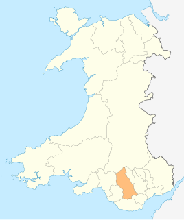
There are 33 Grade I listed buildings in the Vale of Glamorgan all of which are churches and priory buildings, castles, country or manor houses and associated structures such as churchyard crosses and a dovecote.

Merthyr Tydfil County Borough is located in the historic county of Glamorgan in Wales and takes its name from its largest town. The county borough covers an area of 111 km2 (43 sq mi) and had a population of approximately 60,400 in 2020. There are ten structures on the list of twelve Grade II* listed buildings in Merthyr Tydfil. Two viaducts constructed as part of the Brecon and Merthyr Railway both straddle the borders of neighbouring communities so have separate designations for each of these locations.
Monmouthshire is a county and principal area of Wales. It borders Torfaen and Newport to the west; Herefordshire and Gloucestershire to the east; and Powys to the north. The largest town is Abergavenny, with the other major towns being Chepstow, Monmouth, and Usk. The county is 850 km2 in extent, with a population of 95,200 as of 2020. The present county was formed under the Local Government (Wales) Act 1994, and comprises some sixty percent of the historic county. Between 1974 and 1996, the county was known by the ancient title of Gwent, recalling the medieval Welsh kingdom. In his essay on local government in the fifth and final volume of the Gwent County History, Robert McCloy suggests that the governance of "no county in the United Kingdom in the twentieth century was so transformed as that of Monmouthshire".
Rhondda Cynon Taf is a county borough in South Wales. It is located to the north-west of Cardiff and covers an area of 424 km2 (164 sq mi). In 2020 the population was approximately 241,900.
In the United Kingdom, the term listed building refers to a building or other structure officially designated as being of special architectural, historical, or cultural significance; Grade II* structures are those considered to be "particularly important buildings of more than special interest". Listing was begun by a provision in the Town and Country Planning Act 1947. Once listed, strict limitations are imposed on the modifications allowed to a building's structure or fittings. In Wales, the authority for listing under the Planning Act 1990 rests with Cadw.

Castle Farmhouse is a medieval farmhouse in St Georges super Ely, in the Vale of Glamorgan, south Wales. Its origins are as part of the Norman castle of the Le Flemings, after which it declined in status, first to a manor house, and subsequently to a farmstead. It was designated a Grade I listed building on 14 February 1952.
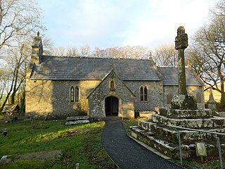
St Canna Church is a church in Llangan, in the Vale of Glamorgan, south Wales. Its churchyard cross is a Grade I listed building, listed on 22 July 2003.

Trewyn House, Llanvihangel Crucorney, Monmouthshire, Wales, is a country house dating from 1692. Its origins are older but the present building was constructed by the Delahayes at the very end of the 17th century when the house sat in Herefordshire. It has since been extended and reconstructed giving an "obscure and complicated" building history. The house is Grade II* listed. The parkland has traces of 17th-century terracing and a rare Grade II* listed dovecote.

The Dovecote, Hygga, Trellech, Monmouthshire is a late 16th-century dovecote, in an unusually complete state of preservation. Part of the service buildings for the, now demolished, Hygga House, the dovecote is a Grade II* listed building and a scheduled monument.
Llanddewi Court, Llanddewi Skirrid, Monmouthshire, Wales, is a Grade II* listed house dating from the late 16th century. It is an example of a "double-house", a building in two sections, originally without interconnections, and designed to accommodate two families.

The Church of St Andrew, Penrice, Swansea, Wales dates from the 12th century. A Grade II* listed building, St Andrew's remains an active parish church in the parish of South-West Gower, in the Diocese of Swansea and Brecon.

Kemeys Manor, Langstone, Newport, Wales, is a manor house dating from the 13th century. The family that built it was established in South Wales in the Middle Ages by Edward, Lord of Kemeys and the manor was held by his descendants until the 18th century. The building was greatly enlarged in the 16th and 17th centuries and comprises a tower, hall and attached ranges. Kemeys is a Grade II* listed building. A barn to the north of the house, and Kemeys Folly to the south, are both listed at Grade II. The manor and the folly remain private residences and are not open to the public.


