Flower's Cove

Last updated

Flower's Cove
Town
Canada Newfoundland location map.svg
Red pog.svg
Flower's Cove
Location of Flower's Cove in Newfoundland
Coordinates: 51°17′0″N56°44′0″W / 51.28333°N 56.73333°W / 51.28333; -56.73333
Country Flag of Canada (Pantone).svg  Canada
Province Flag of Newfoundland and Labrador.svg  Newfoundland and Labrador
Population
 (2021)
  Total272
Time zone UTC-3:30 (Newfoundland Time)
  Summer (DST) UTC-2:30 (Newfoundland Daylight)
Area code 709
Highways NL Route 430.svg Route 430
Flower's Cove Lighthouse OOjs UI icon edit-ltr-progressive.svg
Constructed1899 (first)
Foundationconcrete base (current)
Constructionwoody tower (first)
metal skeletal tower (current)
Height15.5 metres (51 ft) (first)
4 metres (13 ft) (current)
Shapequadrangular atop the keeper’s house with balcony and lantern (first)
square pyramidal skeletal tower with balcony and light (current)
Markingswhite tower (first)
grey metal skeletal tower (current)
Power sourcemains electricity  OOjs UI icon edit-ltr-progressive.svg
OperatorTown of Flower's Cove [1] [2] [3]
First lit1969 (current)
Deactivated1969 (first)
Focal height5 metres (16 ft) (current)
Range4 nmi (7.4 km; 4.6 mi)  OOjs UI icon edit-ltr-progressive.svg
Characteristic Fl G 3s  OOjs UI icon edit-ltr-progressive.svg

Flower's Cove is a town in the Canadian province of Newfoundland and Labrador. The town had a population of 272 in the Canada 2021 Census. It is known for its thrombolite fossils.

Contents

Geography

Climate

Flower's Cove has a subarctic climate (Koppen: Dfc) per usual of the Great Northern Peninsula. Summers are short, cool and rainy, while winters are long, very cold, and snowy, with annual snowfall averaging 109 inches (277 cm). Summer typically begins by late June and can last until the end of September. Autumn is short but cool, with highs in the mid-40s (°F) and lows in the mid-30s (°F). Winter usually begins during November, sometimes late October, and can last into May. Springs are cool and relatively dry, and typically start during May and end during June, where summer begins. [4]

Climate data for Flowers Cove 1981 to 2010 Canadian Climate Normals station data
MonthJanFebMarAprMayJunJulAugSepOctNovDecYear
Record high °C (°F)12.0
(53.6)
12.0
(53.6)
10.0
(50.0)
17.0
(62.6)
25.0
(77.0)
24.0
(75.2)
25.0
(77.0)
26.0
(78.8)
24.5
(76.1)
20.0
(68.0)
17.0
(62.6)
11.0
(51.8)
26.0
(78.8)
Average high °C (°F)−6.5
(20.3)
−7.0
(19.4)
−2.3
(27.9)
2.2
(36.0)
7.3
(45.1)
12.2
(54.0)
16.6
(61.9)
17.3
(63.1)
13.7
(56.7)
7.7
(45.9)
2.6
(36.7)
−2.4
(27.7)
5.1
(41.2)
Daily mean °C (°F)−10.8
(12.6)
−11.4
(11.5)
−6.2
(20.8)
−1.0
(30.2)
3.7
(38.7)
7.9
(46.2)
12.5
(54.5)
13.4
(56.1)
9.8
(49.6)
4.4
(39.9)
−0.4
(31.3)
−5.8
(21.6)
1.3
(34.4)
Average low °C (°F)−15.5
(4.1)
−15.8
(3.6)
−10.2
(13.6)
−4.2
(24.4)
0.1
(32.2)
3.7
(38.7)
8.4
(47.1)
9.5
(49.1)
5.9
(42.6)
1.1
(34.0)
−3.5
(25.7)
−9.3
(15.3)
−2.5
(27.5)
Record low °C (°F)−30.0
(−22.0)
−34.0
(−29.2)
−31.0
(−23.8)
−21.0
(−5.8)
−9.0
(15.8)
−4.0
(24.8)
−1.0
(30.2)
2.0
(35.6)
−2.0
(28.4)
−9.0
(15.8)
−18.0
(−0.4)
−29.0
(−20.2)
−34.0
(−29.2)
Average precipitation mm (inches)87.9
(3.46)
70.8
(2.79)
71.9
(2.83)
56.4
(2.22)
76.1
(3.00)
106.5
(4.19)
107.6
(4.24)
102.3
(4.03)
99.2
(3.91)
96.5
(3.80)
79.3
(3.12)
84.7
(3.33)
1,039.2
(40.92)
Average rainfall mm (inches)16.0
(0.63)
12.4
(0.49)
21.8
(0.86)
31.0
(1.22)
70.4
(2.77)
105.9
(4.17)
107.6
(4.24)
102.3
(4.03)
99.2
(3.91)
94.0
(3.70)
65.6
(2.58)
36.6
(1.44)
762.8
(30.04)
Average snowfall cm (inches)72
(28)
58
(23)
50
(20)
25
(9.8)
6
(2.4)
1
(0.4)
0
(0)
0
(0)
0
(0)
3
(1.2)
14
(5.5)
48
(19)
277
(109.3)
Average precipitation days (≥ 0.2 mm)13.212.411.411.212.715.115.114.614.615.514.313.8163.9
Average rainy days (≥ 0.2 mm)2.42.53.66.311.715.015.114.614.615.210.14.3115.4
Average snowy days (≥ 0.2 cm)11.710.68.34.91.00.130000.483.99.550.51
Source: Environment Canada [5]

Demographics

In the 2021 Census of Population conducted by Statistics Canada, Flower's Cove had a population of 272 living in 119 of its 144 total private dwellings, a change of

Sights

Flower's Cove is famous for thrombolites, very rare fossils which can be seen on the coast in the southern part of the town, remnants of bacteria and algae. They are about 650 million years old. The only places where thrombolites were found are Flower's Cove and Western Australia. [7]

There are three churches in Flower's Cove, the most famous and largest of which is St. Barnabas Anglican Church. It is known as Skin Boot Church, as leather shoes were sold for the church fund when the church was built in the 1920s. Flower's Cove United Church is the smallest. It has a flèche instead of a spire.

Marjorie Bridge is a red-roofed bridge dating from the beginning of the 20th century. [8] It is close to the Roman Catholic Church Lady of Snow, which is more than 100 years old. The church was renovated in 2007. It is a part of Our Lady of Grace Parish in Bird Cove, which belongs to the diocese of St. George.

See also

Related Research Articles

<span class="mw-page-title-main">St. John's, Newfoundland and Labrador</span> Capital and largest city of Newfoundland and Labrador, Canada

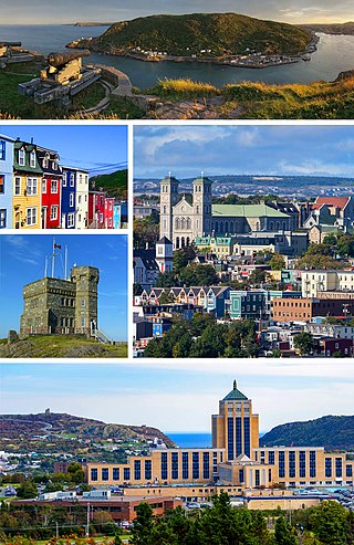
St. John's is the capital and largest city of the Canadian province of Newfoundland and Labrador. It is located on the eastern tip of the Avalon Peninsula on the island of Newfoundland. The city spans 446.04 km2 (172.22 sq mi) and is the easternmost city in North America.

<span class="mw-page-title-main">Arnold's Cove</span> Town in Newfoundland and Labrador, Canada

Arnold's Cove is a town on Newfoundland's Avalon Peninsula in the province of Newfoundland and Labrador, Canada. It is in Division 1 on Placentia Bay.

Upper Island Cove, Newfoundland and Labrador is a town in Newfoundland and Labrador. It is located in Division 1, Newfoundland and Labrador census division. It is north east of Bay Roberts. The Way office was established in 1864. The population was 942 in 1940; 1,346 in 1951, 1,563 in 1956, and 1762 in 1966. As of 2021, the population is 1,401.

<span class="mw-page-title-main">Twillingate</span> Place in Newfoundland and Labrador, Canada

Twillingate is a town of 2,121 people located on the Twillingate Islands ("Toulinquet") in Notre Dame Bay, off the north eastern shore of the island of Newfoundland in the province of Newfoundland and Labrador, Canada. The town is about 100 kilometres (62 mi) north of Lewisporte and Gander.

<span class="mw-page-title-main">Grand Bank</span> Town in Newfoundland and Labrador, Canada

Grand Bank or 'Grand Banc' as the first French settlers pronounced it, is a small rural town in the Canadian province of Newfoundland and Labrador, with a population of 2,580. It is located on the southern tip or "toe" of the Burin Peninsula, 360 km from the province's capital of St. John's.

<span class="mw-page-title-main">Grates Cove, Newfoundland and Labrador</span> Local service district / designated place in Newfoundland and Labrador, Canada

Grates Cove is a local service district and designated place in the Canadian province of Newfoundland and Labrador. It is the most northerly community on the Avalon Peninsula, located on the tip of the Bay de Verde Peninsula on the island of Newfoundland. Called "the Grates" by John Guy as early as 1612, the origin of the name is unknown.

Hant's Harbour is an incorporated town located on the east side of Trinity Bay on the Bay de Verde Peninsula in the province of Newfoundland and Labrador, Canada. It has a population of 318 according to the 2021 Canadian census.

Brigus is a small fishing community located in Conception Bay, Newfoundland and Labrador, Canada. Brigus was home to Captain Bob Bartlett and the location of his residence Hawthorne Cottage.

<span class="mw-page-title-main">Anchor Point, Newfoundland and Labrador</span> Town in Newfoundland and Labrador, Canada

Anchor Point is a town located in St. Barbe Bay, south of Flower's Cove on the west side of the Great Northern Peninsula, in Newfoundland and Labrador, Canada. It was the first English settlement on what is called the 'French Shore' of Newfoundland.

<span class="mw-page-title-main">Woody Point, Newfoundland and Labrador</span> Town in Newfoundland and Labrador, Canada

Woody Point is a town located in the heart of Gros Morne National Park, on the western coast of Newfoundland. Situated on Bonne Bay, the Town of Woody Point encompasses three areas: Curzon Village, Woody Point and Winterhouse Brook. It has a total population of 244 residents. Woody Point is a Registered Heritage District and has a waterfront with many heritage buildings and four Registered Newfoundland and Labrador Heritage Structures. The community is served by Route 431.

<span class="mw-page-title-main">Rencontre East</span> Town in Newfoundland and Labrador, Canada

Rencontre East is a small, outport community in Newfoundland and Labrador, Canada located north east of Belleoram, and west of Terrenceville in Fortune Bay. The population was 115 in the 2021 census. This small community is not connected to any surrounding areas by road but is accessible by scheduled ferry service from ports in Pool's Cove and Bay L'Argent.

<span class="mw-page-title-main">Reefs Harbour-Shoal Cove West-New Ferolle</span> Lighthouse

Reefs Harbour-Shoal Cove West-New Ferolle is a local service district and designated place in the Canadian province of Newfoundland and Labrador. It is southwest of Anchor Point.

<span class="mw-page-title-main">Rose Blanche-Harbour le Cou</span> Town in Newfoundland and Labrador, Canada

Rose Blanche – Harbour le Cou is a small town on Newfoundland's southwest shore, about 45 km at the end of Route 470 from Port aux Basques. This community is located in a barren area on the east side of a small bay. In this bay there are 2 harbours that were mainly used to provide shelter for fishing vessels. Scenery includes the rugged granite coastline, and the white and rocky cliffs of "Diamond Cove". Its granite lighthouse was in operation from 1873 to the 1940s. After it was abandoned in the 1940s the building fell into ruins. The spiral stone staircase extends into the tower wall and kept the tower from collapsing while the remainder of the lighthouse fell to ruin. In 1999 the lighthouse was fully reconstructed and serves as a tourist attraction.

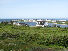
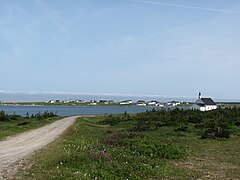
Bay de Verde is an incorporated town in Conception Bay on the northern tip of the Bay de Verde Peninsula of Newfoundland and Labrador, Canada. The first recorded inhabitants at Bay de Verde arrived in 1662. Bay de Verde became an incorporated town in 1950.

<span class="mw-page-title-main">Flatrock, Newfoundland and Labrador</span> Town in Newfoundland and Labrador, Canada

Flatrock is a town in Newfoundland and Labrador. The town had a population of 1,722 in the Canada 2021 Census.

South River is an incorporated municipality in the Canadian province of Newfoundland and Labrador, located at the south-southeast side of Bay de Grave, in Conception Bay. The town had a population of 674 according to the 2021 Canadian Census. South River is the site of the western terminus of Newfoundland and Labrador Route 60, also known as the Conception Bay Highway, which proceeds eastward to downtown St. John's. The river itself forms a natural boundary with neighbouring Clarke's Beach and is a scheduled salmon river. A second river, known as the Gould Brook, forms another natural boundary with the unincorporated local service district of Makinsons. South River is home to the Bay de Grave Regional Fire Department, a first step in developing successful regional cooperation amongst municipalities.

St. Mary's is a town in the Canadian province of Newfoundland and Labrador. The town had a population of 313 in the Canada 2021 Census.

Winterton is a town in the Canadian province of Newfoundland and Labrador. It was originally named Sille Cove or Scilly Cove. In 1912 the town was named Winterton for Sir James Spearman Winter, former Prime Minister of Newfoundland.

<span class="mw-page-title-main">St. Jacques-Coomb's Cove</span> Town in Newfoundland and Labrador, Canada

St. Jacques-Coomb's Cove is a town in the Canadian province of Newfoundland and Labrador. The town had a population of 546 in the Canada 2021 Census. It is located on the south coast of the island of Newfoundland on the north side of Fortune Bay, on the southern tip of the Connaigre Peninsula in what is now known as the Coast of Bays Region. The town consists of six communities, St. Jacques, English Harbour West, Mose Ambrose, Boxey, Coomb's Cove, and Wreck Cove, all nestled within the inlets along the coast. They all had their beginnings in the fisheries and the fisheries have always been the mainstay of employment in the communities. In recent years aquaculture was introduced in the area, providing employment for its residents.

<span class="mw-page-title-main">Brig Bay</span>

Brig Bay is a local service district and designated place in the Canadian province of Newfoundland and Labrador. It was first mapped by Captain James Cook in September 1764. The name "Brig" was adopted by the French who occupied the bay prior to English occupation. It provided a safe and well-sheltered harbour.

References

  1. Rowlett, Russ. "Lighthouses of Canada: Southwestern Newfoundland". The Lighthouse Directory. University of North Carolina at Chapel Hill . Retrieved 2017-02-15.
  2. Flower's Cove Lighthouse Friends. Retrieved 15 February 2017
  3. List of Lights, Pub. 110: Greenland, The East Coasts of North and South America (Excluding Continental U.S.A. Except the East Coast of Florida) and the West Indies (PDF). List of Lights . United States National Geospatial-Intelligence Agency. 2016.
  4. Canada, Environment and Climate Change (2013-09-25). "Canadian Climate Normals 1981-2010 Station Data - Climate - Environment and Climate Change Canada". climate.weather.gc.ca. Retrieved 2020-05-28.
  5. "Canadian Climate Normals - Climate - Environment and Climate Change Canada". 31 October 2011.
  6. "Population and dwelling counts: Canada, provinces and territories, census divisions and census subdivisions (municipalities), Newfoundland and Labrador". Statistics Canada. February 9, 2022. Retrieved March 15, 2022.
  7. Andrew Hampstead: Atlantic Canada, p. 380. Berkeley CA 2012.
  8. Andrew Hampstead: Atlantic Canada, p. 379. Berkeley CA 2012.

51°17′57.42″N56°43′42.39″W / 51.2992833°N 56.7284417°W / 51.2992833; -56.7284417