Tottori, Tottori

Last updated
Tottori
鳥取市
Core city

Tottori montage.jpg

From top left:Tottori Castle, Shikano(old castle town), Tottori Sand Dunes, Jinpūkaku, View of Tottori from Tottori Castle
Flag of Tottori, Tottori.svg
Flag
Symbol of Tottori, Tottori.svg
Emblem
Tottori City in Tottori Prefecture Ja.svg
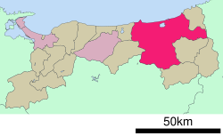
Location of Tottori in Tottori Prefecture
Japan location map with side map of the Ryukyu Islands.svg
Red pog.svg
Tottori
Location in Japan
Coordinates: 35°30′N134°14′E / 35.500°N 134.233°E / 35.500; 134.233 Coordinates: 35°30′N134°14′E / 35.500°N 134.233°E / 35.500; 134.233
Country Japan
Region Chūgoku (Sanin)
Prefecture Tottori Prefecture
Government
  Mayor Yoshihiko Fukazawa [1]
Area
  Total 765.31 km2 (295.49 sq mi)
Population (June 1, 2016)
  Total 192,912
  Density 250/km2 (650/sq mi)
Symbols
  Tree Camellia sasanqua
  Flower Allium chinense
  Bird Blue-and-white flycatcher
Time zone Japan Standard Time (UTC+9)
City hall address 116 Shutoku-cho, Tottori-shi, Tottori-ken
680-8571
Website city.tottori.lg.jp

Tottori(鳥取市,Tottori-shi) is the capital city of Tottori Prefecture in the Chūgoku region of Japan.

Cities of Japan administrative division of Japan

A city is a local administrative unit in Japan. Cities are ranked on the same level as towns and villages, with the difference that they are not a component of districts. Like other contemporary administrative units, they are defined by the Local Autonomy Law of 1947.

Tottori Prefecture Prefecture of Japan

Tottori Prefecture is a prefecture of Japan located in the Chūgoku region. The capital is the city of Tottori. It is the least populous prefecture in Japan.

Chūgoku region Region

The Chūgoku region, also known as the San'in-San'yō region, is the westernmost region of Honshū, the largest island of Japan. It consists of the prefectures of Hiroshima, Okayama, Shimane, Tottori, and Yamaguchi. In 2010, it had a population of 7,563,428.

Contents

As of June 1, 2016, the city has an estimated population of 192,912 and a population density of 250 persons per km2. The total area is 765.31 km2.

Population All the organisms of a given species that live in the specified region

In biology, a population is the number of all the organisms of the same group or species, which live in a particular geographical area, and have the capability of interbreeding. The area of a sexual population is the area where inter-breeding is potentially possible between any pair within the area, and where the probability of interbreeding is greater than the probability of cross-breeding with individuals from other areas.

Population density A measurement of population numbers per unit area or volume

Population density is a measurement of population per unit area or unit volume; it is a quantity of type number density. It is frequently applied to living organisms, and most of the time to humans. It is a key geographical term. In simple terms population density refers to the number of people living in an area per kilometer square.

Within Japan the city is best known for its sand dunes which are a popular tourist attraction, drawing visitors from outside the prefecture. The sand dunes are also important as a centre for research into arid agriculture, hosting Tottori University's Arid Land Research Center. Most of Tottori is located in the western part of the San'in Kaigan Geopark.[ citation needed ]

Tottori Sand Dunes dunes in Tottori, Japan

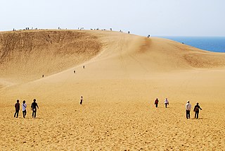
The Tottori Sand Dunes are sand dunes located near the city of Tottori in Tottori Prefecture, Japan. They form the only large dune system in Japan.

Tottori University higher education institution in Tottori Prefecture, Japan

National University Corporation Tottori University, abbreviated to Toridai (鳥大), is a national university in Japan. The main campus is located in Koyamachō-Minami, Tottori City, Tottori Prefecture. Another campus, the Faculty of Medicine, is located on the Yonago Campus in Yonago, Tottori.

Sanin Kaigan Geopark

The San'in Kaigan Geopark (山陰海岸ジオパーク) is a geopark in Japan. The area was declared a Japanese Geopark in 2008, and a UNESCO Global Geopark in 2010. The underlying themes of the geopark are "geological features, the natural environment, people's lives, and the formation of the Sea of Japan". This geologically diverse area contains records of the process from when Japan was part of the Asian continent to its present-day formation of the Sea of Japan. People's lives are also diverse in this area because of its geodiversity.

Outline

The city's main street (Wakasa, or "young cherry blossom" street) runs north from the station and terminates at the foot of the Kyushouzan ("eternal pine") mountain. Around this mountain lies the oldest part of the city. Its centre is the now ruined Tottori Castle, once the property of the Ikeda clan daimyō who ruled the Tottori Domain during the Edo period. It is open to the public, and is the site of the Castle Festival in autumn each year. In the vicinity are temples, museums, and public parks. The city also hosts the prefecturally famous Shan-shan festival in the summer, which features teams of people dressing up and dancing with large umbrellas; the name 'Shan-shan' is said to come from the sound made by the small bells and pieces of metal attached to the umbrellas, which are very large. An exceptionally big example of a Shan-shan umbrella graces the main foyer of Tottori Station.

Cherry blossom

A cherry blossom is a flower of several trees of genus Prunus, particularly the Japanese cherry, Prunus serrulata, which is called sakura after the Japanese.

Tottori Castle castle ruins in Tottori, Japan

Tottori Castle was the central castle of the Tottori han (fief) in feudal Japan. It was a yamashiro, or "mountain castle", built into the mountain itself, using natural obstacles and defenses to a greater extent than man-made walls. Little remains of the castle aside from parts of the stone wall and one gate, reinforced with iron and featuring spikes on the outside of the doors to help protect against attackers.

Ikeda clan

Ikeda clan was a Japanese clan that claimed descent from the Seiwa Genji. In the Edo period, several of the clan's branches were daimyō families, most notably of the Tottori Domain and Okayama Domain. Takamasa Ikeda, former head of the Okayama Ikeda house was the husband of Atsuko Ikeda, fourth daughter of Emperor Shōwa.

At the beginning of every summer, Tottori is host to one of the biggest beach parties in the country, the San In Beach Party. The event lasts an entire weekend and some top names on the national DJ circuit are invited to perform.

History

Tottori was incorporated as a city on October 1, 1889. Most of the downtown area was destroyed by the Tottori earthquake of September 10, 1943, which killed over 1000 people.

1943 Tottori earthquake earthquake struck Tottori prefecture, Japan on September 10, 1943 (local time)

The Tottori earthquake occurred in Tottori prefecture, Japan at 17:36 local time on September 10, 1943. Although the earthquake occurred during World War II, information about the disaster was surprisingly uncensored, and relief volunteers and supplies came from many parts of the Japanese empire, including Manchukuo.

The organization AFS (AFS Intercultural Programs) for exchange students is relatively developed in Tottori. Exchange students who come to Tottori can experience countryside life and enjoy traditional Japanese customs through the many events organized by the Tottori AFS.

AFS Intercultural Programs nonprofit organization

AFS Intercultural Programs is an international youth exchange organization. It consists of over 50 independent, not-for-profit organizations, each with its own network of volunteers, professionally staffed offices, volunteer board of directors and website. In 2015, 12,578 students traveled abroad on an AFS cultural exchange program, between 99 countries. The U.S.-based partner, AFS-USA, sends more than 1,100 U.S. students abroad and places international students with more than 2,300 U.S. families each year. More than 424,000 people have gone abroad with AFS and over 100,000 former AFS students live in the U.S.

Redistricting ("gappei") of the city's borders in November 2004 increased its size to include a number of surrounding areas. On November 1, 2004, the town of Kokufu, the village of Fukube (both from Iwami District), the towns of Aoya, Ketaka and Shikano (all from Ketaka District), the towns of Kawahara and Mochigase and the village of Saji (all from Yazu District) were merged into Tottori. Ketaka District was dissolved as a result of this merger.

Education

Tottori City has two universities. The main campus of Tottori University, a national public university, is located next to Koyama Lake on the west end of the city. The privately funded Tottori University of Environmental Studies is located in the south-eastern part of Tottori city, near the town of Yazu. These two universities are not to be confused with the 2-year junior college in the prefecture, Tottori College, which is located in the central city of Kurayoshi.

Transportation

In the city's downtown shopping district, Tottori Station offers regularly scheduled local and express train service on the JR West rail line. Travel time from Osaka is approximately 2 hours 30 minutes. Tottori City's local and inter-city Bus Terminal is also conveniently located next to Tottori Station. On the west end of the city, Tottori Airport provides daily scheduled flights to Tokyo's Haneda Airport.

Notable places

Climate

Tottori has a humid subtropical climate (Köppen climate classification Cfa) with hot summers and cool winters. Precipitation is abundant throughout the year.

Climate data for Tottori, Tottori (1961–1990)
MonthJanFebMarAprMayJunJulAugSepOctNovDecYear
Average high °C (°F)7.4
(45.3)
7.6
(45.7)
11.8
(53.2)
18.3
(64.9)
23.1
(73.6)
26.7
(80.1)
30.1
(86.2)
31.8
(89.2)
26.8
(80.2)
21.4
(70.5)
16.1
(61)
10.9
(51.6)
19.3
(66.7)
Daily mean °C (°F)3.7
(38.7)
3.7
(38.7)
6.9
(44.4)
12.7
(54.9)
17.3
(63.1)
21.7
(71.1)
25.5
(77.9)
26.7
(80.1)
22.0
(71.6)
16.1
(61)
11.2
(52.2)
6.5
(43.7)
14.5
(58.1)
Average low °C (°F)0.5
(32.9)
0.2
(32.4)
2.4
(36.3)
6.9
(44.4)
11.9
(53.4)
17.5
(63.5)
21.7
(71.1)
22.5
(72.5)
18.1
(64.6)
11.6
(52.9)
7.0
(44.6)
2.7
(36.9)
10.3
(50.5)
Average precipitation mm (inches)185.3
(7.295)
165.0
(6.496)
124.6
(4.906)
120.5
(4.744)
121.4
(4.78)
168.0
(6.614)
202.5
(7.972)
134.8
(5.307)
246.6
(9.709)
147.7
(5.815)
162.0
(6.378)
171.1
(6.736)
1,949.5
(76.752)
Average snowfall cm (inches)84
(33.1)
78
(30.7)
16
(6.3)
0
(0)
0
(0)
0
(0)
0
(0)
0
(0)
0
(0)
0
(0)
1
(0.4)
32
(12.6)
211
(83.1)
Average precipitation days19.016.814.811.510.411.910.79.212.811.413.917.1159.5
Average relative humidity (%)74757170717779778077757375
Mean monthly sunshine hours 68.273.4132.2176.7207.7159.0179.8207.7144.4142.6102.083.71,677.4
Source #1: NOAA (1961-1990) [4]
Source #2: HKO (sun only) [5]

Twin towns

Related Research Articles

Inazawa, Aichi City in Chūbu, Japan

Inazawa is a city located in Aichi Prefecture, Japan.

Inaba Province province of Japan

Inaba Province was an old province of Japan in the area that is today the eastern part of Tottori Prefecture. It was sometimes called Inshū (因州). Inaba bordered on Harima, Hōki, Mimasaka, and Tajima Provinces.

Kokufu was a town located in Iwami District, Tottori Prefecture, Japan.

Fukube was a village located in Iwami District, Tottori Prefecture, Japan.

Kawahara was a town located in Yazu District, Tottori Prefecture, Japan.

Wakasa, Tottori Town in Japan

Wakasa is a town located in Yazu District, Tottori Prefecture, Japan.

Mochigase was a town located in Yazu District, Tottori Prefecture, Japan.

Saji was a village located in Yazu District, Tottori Prefecture, Japan.

Ketaka was a town located in Ketaka District, Tottori Prefecture, Japan.

Shikano was a town located in Ketaka District, Tottori Prefecture, Japan.

Aoya was a town located in Ketaka District, Tottori Prefecture, Japan.

Ketaka was a district located in Tottori Prefecture, Japan.

Yonago, Tottori City in Chūgoku, Japan

Yonago is a city in western Tottori Prefecture, Japan, facing the Sea of Japan and making up part of the boundary of Lake Nakaumi. It is adjacent to Shimane Prefecture and across the lake from its capital of Matsue. It is the prefecture's second largest city after Tottori, and forms a commercial center of the western part of this prefecture.

Jinpūkaku

Jinpūkaku is a Western-style French Renaissance style residence of the Ikeda clan located in Tottori, Tottori Prefecture, Japan.

Kannon-in Buddhist temple in Tottori Prefecture, Japan

Kannon-in, formally known as Fudarakusan Jigen-ji Kannon-in (補陀落山慈眼寺観音院), is a Buddhist temple in Uemachi district of the city of Tottori, Tottori Prefecture, Japan. Kannon-in was built early in the Edo period and is noted for its Edo-style Japanese garden.

Sendai River river in Japan

The Sendai River is a river in eastern Tottori Prefecture, Japan. The Sendai is 52 kilometers (32 mi) in length and has a drainage area of 1,190 square kilometers (460 sq mi). The source of the river is in the Chūgoku Mountains. The Sendai flows north through Tottori Prefecture into the Sea of Japan. Under the Rivers Act of 1964 it is designated a Class 1 River, and is managed by the Japanese Ministry of Land, Infrastructure, Transport and Tourism. About 200,000 people live along the course of the river. The Sendai River provides sediment to form the Tottori Sand Dunes, the largest dune system in Japan.

Shikano Domain was a Japanese domain of the Edo period. It was associated with Inaba Province in modern-day Tottori Prefecture.

Shikano Castle was a medieval period castle, situated in Tottori Prefecture. The date the castle was constructed is not known, though the earliest mention of it occurs in 1544. The castle is located south west of Tottori city, in Shikano, Tottori town. It was a small castle, situated not far from the centre of Tottori city. In the period of the construction of the castle, the area was governed by a local clan, the Shikano. The Amago clan moved in on the area, and defeated the Shikano, claiming the castle as theirs. Following this, the castle was put in the lordship of Kamei Korenori (1557–1612). Korenori engaged with foreign trade, which was rare for a lower level lord, and even named some parts of the castle after countries.

References