Takasaki, Gunma

Last updated
Takasaki
高崎市
Core city

View from Takasaki Kannon northeast.jpg

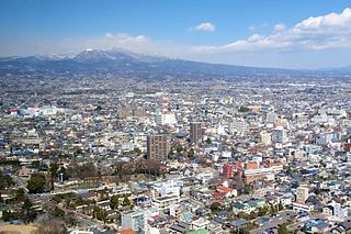
City view from Takasaki Kannon
Flag of Takasaki, Gunma.svg
Flag
Qun Ma Xian Gao Qi Shi Shi Zhang .svg
Seal
Takasaki in Gunma Prefecture Ja.svg
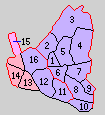
Location of Takasaki in Gunma Prefecture
Japan location map with side map of the Ryukyu Islands.svg
Red pog.svg
Takasaki
 
Coordinates: 36°19′18.8″N139°0′11.8″E / 36.321889°N 139.003278°E / 36.321889; 139.003278 Coordinates: 36°19′18.8″N139°0′11.8″E / 36.321889°N 139.003278°E / 36.321889; 139.003278
Country Japan
Region Kantō
Prefecture Gunma Prefecture
Government
  Mayor Kenji Tomioka (since May 2011)
Area
  Total 459.16 km2 (177.28 sq mi)
Population (December 2015)
  Total 371,750
  Density 810/km2 (2,100/sq mi)
Time zone Japan Standard Time (UTC+9)
Symbols 
• Tree Zelkova serrata , Cyclobalanopsis
• Flower Sakura
• Bird Japanese bush-warbler
Phone number 027-321-111
Address Takamatsu-cho 35-1, Takasaki-shi, Gunma-ken 370-8501
Website http://www.city.takasaki.gunma.jp/
Takasaki City Hall Takasaki City Hall.jpg
Takasaki City Hall

Takasaki(高崎市,Takasaki-shi, [takasakiɕi] ) is a city located in Gunma Prefecture, Japan. As of December 2015, the city had an estimated population of 371,750, and a population density of 810 persons per km2. Its total area is 459.16 square kilometres (177.28 sq mi). Takasaki is famous as the hometown of the Daruma doll, theoretically representing the Buddhist sage Bodhidharma and in modern practice a symbol of good luck.

Cities of Japan administrative division of Japan

A city is a local administrative unit in Japan. Cities are ranked on the same level as towns and villages, with the difference that they are not a component of districts. Like other contemporary administrative units, they are defined by the Local Autonomy Law of 1947.

Gunma Prefecture Prefecture of Japan

Gunma Prefecture is a prefecture of Japan located in the Kantō region. Its capital is Maebashi.

Japan Constitutional monarchy in East Asia

Japan is an island country in East Asia. Located in the Pacific Ocean, it lies off the eastern coast of the Asian continent and stretches from the Sea of Okhotsk in the north to the East China Sea and the Philippine Sea in the south.

Contents

History

During the Edo period, the area of present-day Takasaki was the center of the Takasaki Domain, a feudal domain held by a branch of the Matsudaira clan under the Tokugawa shogunate in Kōzuke Province. The area also prospered from its location on the Nakasendō highway connecting Edo with Kyoto. Post stations located within the borders of modern Takasaki were: Shinmachi-shuku, Kuragano-shuku, and Takasaki-shuku. Following the Meiji Restoration, Takasaki was briefly capital of Gunma Prefecture, before the capital was moved to Maebashi in 1881.

Edo period period of Japanese history

The Edo period or Tokugawa period (徳川時代) is the period between 1603 and 1868 in the history of Japan, when Japanese society was under the rule of the Tokugawa shogunate and the country's 300 regional daimyō. The period was characterized by economic growth, strict social order, isolationist foreign policies, a stable population, "no more wars", and popular enjoyment of arts and culture. The shogunate was officially established in Edo on March 24, 1603, by Tokugawa Ieyasu. The period came to an end with the Meiji Restoration on May 3, 1868, after the fall of Edo.

Takasaki Domain Japanese historical estate

Takasaki Domain was a feudal domain under the Tokugawa shogunate of Edo period Japan, located in Kōzuke Province, Japan. It was centered on Takasaki Castle in what is now part of the city of Takasaki, Gunma. Takasaki was ruled through most of its history by a junior branch of the Matsudaira clan.

The han or domain is the Japanese historical term for the estate of a warrior after the 12th century or of a daimyō in the Edo period (1603–1868) and early Meiji period (1868–1912).

Takasaki Town was created within Gunma District, Gunma on April 1, 1889 with the creation of the municipalities system. It was raised to city status on April 1, 1900. On April 1, 1927, Takasaki annexed the neighboring villages of Tsukasawa and Kataoka, followed by Sano on October 1, 1937. The city largely escaped damage in World War II. Following the war, it continued to expand its borders by annexing the village of Rokugo on April 1, 1951, Shintakao and Nakamura as well as Yawata and Toyooka from Ushi District on January 20, 1955. This was followed by Orui village and Sano village from Tano District on September 30, 1956. The city celebrated its 360th anniversary in 1963 and annexed the town of Kuragano on March 31 of the same year. On September 1, 1965 the village of Gunnan was annexed.

Gunma was a district located in Gunma Prefecture, Japan.

Usui District, Gunma district of Gunma prefecture, Japan

Usui District is a former rural district located in Gunma Prefecture, Japan. All of the city of Annaka and a tall portion of the city of Takasaki were formerly part of the district.

In September 1987, five-year-old Yoshiaki Ogiwara, the son of a local firefighter, was abducted and subsequently murdered in Takasaki. The murder received heavy media coverage across Japan. [1]

On April 1, 2001 Takasaki was proclaimed a Special City (Tokurei-shi), which gave it greater autonomy.

Special cities of Japan type of city of Japan

A special city of Japan is a city with a population of at least 200,000, and is delegated functions normally carried out by prefectural governments. Those functions are a subset of the ones delegated to a core city.

On January 23, 2006, the towns of Gunma, Kurabuchi and Misato (all from Gunma District), and the town of Shinmachi (from Tano District) were merged into Takasaki. On October 1, 2006, the town of Haruna (from Gunma District) was merged into Takasaki. Gunma District was dissolved as a result of this merger. On June 1, 2009, the town of Yoshii (from Tano District) was merged into Takasaki. [2]

Gunma is a former town located in Gunma District, Gunma Prefecture, Japan.

Kurabuchi, Gunma human settlement in Japan

Kurabuchi was a town located in Gunma District, Gunma Prefecture, Japan.

Misato was a town located in Gunma District, Gunma Prefecture, Japan.

Takasaki was elevated to a Core city with even greater autonomy on April 1, 2011.

Geography

Takasaki is located in the southwestern part of Gunma Prefecture in the flat northern part of the Kantō Plain.

Surrounding municipalities

Economy

Takasaki is a regional commercial center and transportation hub, and is a major industrial center within Gunma Prefecture. Companies headquartered in Takasaki include:

Education

There are 9 public and 5 private high schools, 25 middle schools, and 60 elementary schools in Annaka.

Universities and colleges

Primary and secondary education

Transportation

Railway

The city of Takasaki is served by the following JR East lines:

Highway

Local attractions

Sport

Sister-city relations

Notable people

Related Research Articles

Shibukawa, Gunma City in Kantō, Japan

Shibukawa is a city in Gunma Prefecture, Japan. As of February 2016, the city had an estimated population of 78,178, and a population density of 325 persons per km². Its total area is 240.27 square kilometres (92.77 sq mi). Shibukawa is the location of Ikaho Onsen, a popular hot spring resort.

Annaka, Gunma City in Kantō, Japan

Annaka is a city located in Gunma Prefecture, Japan. As of February 2015, the city had an estimated population of 58,675, and a population density of 212 persons per km². Its total area is 276.31 km².

Shintō, Gunma Village in Kantō, Japan

Shintō is a village located in Gunma Prefecture, Japan. As of February 2015, the village had an estimated population of 14,343, and a population density of 514 persons per km2. Its total area is 27.92 km2.

Yoshioka, Gunma Town in Kantō, Japan

Yoshioka is a town located in Gunma Prefecture, Japan. As of February 2015, the town had an estimated population of 20,847, and a population density of 1020 persons per km². Its total area is 20.46 km².

Yoshii was a town located in Tano District, Gunma Prefecture, Japan.

Tano District, Gunma district of Japan

Tano District is a rural district located in Gunma Prefecture, Japan. As of January 2015, the district had an estimated population of 3,272 and an area of 296.45 km², with a population density of 11 people per square kilometer.

Tamamura, Gunma Town in Kantō, Japan

Tamamura is a town located in Gunma Prefecture, Japan. As of February 2015, the town had an estimated population of 36,952, and a population density of 1430 persons per km². Its total area is 25.78 km².

Ryōmō Line railway line in Japan

The Ryōmō Line is a Japanese railway line connecting Oyama in Tochigi Prefecture with Maebashi in Gunma Prefecture. 84.4 km (52.4 mi) long, the line is owned and operated by the East Japan Railway Company. The name refers to the fact that Gunma and Tochigi prefectures were once part of an ancient province called Keno (毛野), which was later split into Kōzuke (Gunma) and Shimotsuke (Tochigi). This line connects both halves of the old province.

Maebashi Core city in Kantō, Japan

Maebashi is a city located in Gunma Prefecture, in the northern Kantō region of Japan. It is the capital city of Gunma Prefecture.

Isesaki, Gunma Special city in Kantō, Japan

Isesaki is a city located in Gunma Prefecture, Japan. As of February 2015, the city had an estimated population of 208,705, and a population density of 1500 persons per km². Its total area is 139.44 km².

69 Stations of the Nakasendō

The 69 Stations of the Nakasendō are the rest areas along the Nakasendō, which ran from Nihonbashi in Edo to Sanjō Ōhashi in Kyoto. The route stretched approximately 534 km (332 mi) and was an alternate trade route to the Tōkaidō.

Shinmachi-shuku

Shinmachi-shuku was the eleventh of the sixty-nine stations of the Nakasendō. It is located in the present-day city of Takasaki, Gunma Prefecture, Japan.

Kuragano-shuku

Kuragano-shuku was the twelfth of the sixty-nine stations of the Nakasendō. It is located in the present-day city of Takasaki, Gunma Prefecture, Japan.

Japan National Route 18 road in Japan

National Route 18 is a national highway connecting Takasaki, Gunma and Joetsu, Niigata in Japan.

Nawa District, Gunma

Nawa District was formerly a rural district located in Gunma Prefecture, Japan. The district is now divided between the cities of Isesaki and Maebashi, with a remaining portion forming Sawa District and the town of Tamamura

References

  1. Kristof, Nicholas D. "Kidnap-murder of 5-year-old shakes Japan," The New York Times, 20 September 1987. Retrieved 12 April 2015.
  2. Information at kokudo.or.jp Archived August 21, 2006, at the Wayback Machine .
  3. "100 Soundscapes of Japan". Ministry of the Environment . Retrieved 8 December 2015.