Chiba, Chiba

Last updated
Chiba
千葉市
Designated city
Chiba montage.jpg
Top: Coastal industrial area, Chiba Folk Museum
Middle: Makuhari Messe, Chiba Port Tower, Chiba Marine Stadium
Bottom: Skyscrapers of Makuhari on the coast.
Flag of Chiba, Chiba.svg
Flag
Chiba in Chiba Prefecture Ja.svg
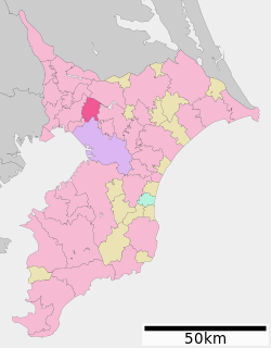
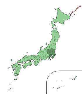
Location of Chiba in Chiba Prefecture
Japan location map with side map of the Ryukyu Islands.svg
Red pog.svg
Chiba
 
Coordinates: 35°36′26.2″N140°06′22.9″E / 35.607278°N 140.106361°E / 35.607278; 140.106361 Coordinates: 35°36′26.2″N140°06′22.9″E / 35.607278°N 140.106361°E / 35.607278; 140.106361
Country Japan
Region Kantō
Prefecture Chiba Prefecture
Government
  Mayor Toshihito Kumagai
Area
  Total 271.76 km2 (104.93 sq mi)
Population (February 1, 2016)
  Total 972,861
  Density 3,580/km2 (9,300/sq mi)
Time zone Japan Standard Time (UTC+9)
-Tree Zelkova serrata
– Flower Nelumbo nucifera
– Bird Little tern
Phone number 043-245-5111
Address 1-1 Chiba-minato, Chūō-ku, Chiba-shi 260-8722
Website https://www.city.chiba.jp/
Chiba
Chiba (Chinese characters).svg
"Chiba" in kanji
Japanese name
Kanji 千葉
Hiragana ちば
Katakana チバ

Chiba(千葉市,Chiba-shi, Japanese:  [tɕiꜜba] ), literally "Thousand(s) Leaves", is the capital city of Chiba Prefecture, Japan. It sits about 40 kilometres (25 mi) southeast of the center of Tokyo on Tokyo Bay. [1] Chiba City became a government-designated city in 1992. In February 2016, its population was 972,861, with a population density of 3,580 people per square kilometer. The city has an area of 271.76 square kilometres (104.93 sq mi).

Cities of Japan administrative division of Japan

A city is a local administrative unit in Japan. Cities are ranked on the same level as towns and villages, with the difference that they are not a component of districts. Like other contemporary administrative units, they are defined by the Local Autonomy Law of 1947.

Chiba Prefecture Prefecture of Japan

Chiba Prefecture is a prefecture of Japan located in the Kantō region, and the Greater Tokyo Area. The sixth most populous prefecture, and 27th largest by land area, Chiba is on the east coast of Honshu and largely consists of the Bōsō Peninsula, which encloses the eastern side of Tokyo Bay. Its capital is the city of Chiba.

Japan Constitutional monarchy in East Asia

Japan is an island country in East Asia. Located in the Pacific Ocean, it lies off the eastern coast of the Asian continent and stretches from the Sea of Okhotsk in the north to the East China Sea and the Philippine Sea in the south.

Contents

Chiba City is one of the Kantō region's primary seaports, and is home to Chiba Port, which handles one of the highest volumes of cargo in the nation. Much of the city is residential, although there are many factories and warehouses along the coast. There are several major urban centers in the city, including Makuhari, a prime waterfront business district in which Makuhari Messe is located, and Central Chiba, in which the prefectural government office and the city hall are located.

Kantō region Region

The Kantō region is a geographical area of Honshu, the largest island of Japan. The region includes the Greater Tokyo Area and encompasses seven prefectures: Gunma, Tochigi, Ibaraki, Saitama, Tokyo, Chiba, and Kanagawa. Within its boundaries, slightly more than 45 percent of the land area is the Kantō Plain. The rest consists of the hills and mountains that form the land borders. According to the official census on October 1, 2010 by the Japan Statistics Bureau, the population was 42,607,376, amounting to approximately one third of the total population of Japan.

Makuhari area in Chiba city

Makuhari (幕張) is a community in Chiba City, Chiba Prefecture, Japan. It is within Hanamigawa-ku and Mihama-ku.

Makuhari Messe Japanese convention center in the Mihama-ku of Chiba city

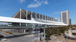
Makuhari Messe (幕張メッセ) is a Japanese convention center outside Tokyo, located in the Mihama-ku ward of Chiba city, in the northwest corner of Chiba prefecture. Designed by Fumihiko Maki, it is easily accessible by Tokyo's commuter rail system. Makuhari is the name of the area, and Messe is a German language word meaning "trade fair".

Chiba is famous for the Chiba Urban Monorail, the longest suspended monorail in the world. Some popular destinations in the city include: Kasori Shell Midden, the largest shellmound in the world at 134,000 m2 (160,000 sq yd), Inage Beach, the first artificial beach in the nation which forms part of the longest artificial beach in Japan, and the Chiba City Zoological Park, popular on account of the standing red panda Futa.

Chiba Urban Monorail

The Chiba Urban Monorail is a two-line suspended monorail system located in Chiba, Chiba Prefecture, Japan. It is owned and operated by Chiba Urban Monorail Co., Ltd, a so-called "third-sector" company established on March 20, 1979. Investors include Chiba Prefecture and the city of Chiba.

Monorail single-rail based transportation system

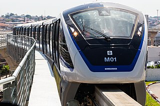
A monorail is a railway in which the track consists of a single rail. The term is also used to describe the beam of the system, or the trains traveling on such a beam or track. The term originates from joining "mono" (one) and "rail" (rail), from 1897, possibly from German engineer Eugen Langen, who called an elevated railway system with wagons suspended the Eugen Langen One-railed Suspension Tramway.

Red panda species of mammal

The red panda is a mammal native to the eastern Himalayas and southwestern China. It is listed as Endangered on the IUCN Red List because the wild population is estimated at fewer than 10,000 mature individuals and continues to decline due to habitat loss and fragmentation, poaching, and inbreeding depression.

Etymology

The name of Chiba in the Japanese language is formed from two kanji characters. The first, , means "thousand" and the second, means "leaves". The name first appears as an ancient kuni no miyatsuko , or regional command office, as the Chiba Kuni no Miyatsuko(千葉国造). [2] The name was adopted by a branch of the Taira clan, which moved to the area in present-day Chiba City in the late Heian period. The branch of the Taira adopted the name and became the Chiba clan, which held strong influence over the area of the prefecture until the Azuchi–Momoyama period. The name "Chiba" was chosen for Chiba Prefecture at the time its creation in 1873 by the Assembly of Prefectural Governors (地方官会議,Chihō Kankai Kaigi), an early Meiji-period body of prefectural governors that met to decide the structure of local and regional administration in Japan. [3]

Japanese is an East Asian language spoken by about 128 million people, primarily in Japan, where it is the national language. It is a member of the Japonic language family, and its relation to other languages, such as Korean, is debated. Japanese has been grouped with language families such as Ainu, Austroasiatic, and the now-discredited Altaic, but none of these proposals has gained widespread acceptance.

<i>Kanji</i> adopted logographic Chinese characters used in the modern Japanese writing system

Kanji are the adopted logographic Chinese characters that are used in the Japanese writing system. They are used alongside the Japanese syllabic scripts hiragana and katakana. The Japanese term kanji for the Chinese characters literally means "Han characters". It is written with the same characters in the Chinese language to refer to the character writing system, hanzi (漢字).

Kuni no miyatsuko (国造), also read as "kokuzō" or "kunitsuko", were officials in ancient Japan at the time of the Yamato court.

History

Early history

The first records related to the city of Chiba record the emigration of Taira Tsuneshige (1083?1088), a powerful bushi warlord of the late Heian period, to Shimōsa Province, which historically occupied the north of Chiba Prefecture. Tsuneshige was appointed as gunji administrator of Sōma District, but was transferred to the same position in Chiba District two years later. Here he proclaimed himself Chiba Tsuneshige (千葉常重), became a kokushi governor of the province, and used the area around present-day Chiba City as a power base to rule over Shimōsa Province, Kazusa Province, as well as establish himself as a military force in the Kantō region. [4] Tsuneshige's son, Chiba Tsunetane (千葉常胤) (1118–1201) was instrumental in aiding Minamoto no Yoritomo (1147–1199) with the establishment of the Kamakura shogunate. Tsuneshige built a spacious residence and numerous temples in present-day Chiba City, and in the same period he transferred his power base from Ōji Castle to Inohana Castle on Mount Inohana. [5] The area of present-day Chiba City became jōkamachi (城下町), or castle town, and prospered under the Chiba clan. [6] The clan's power extended in the region until the Muromachi period. [7] [8]

Taira Tuneshige was a bushi acting around the Kantō region in the latter period of the Heian period. He is a descendant of Emperor Kanmu (桓武天皇) and of Taira Tadatsune. His father is Taira Tsunekane and His mother is a daughter of Torinoumi Saburō-Tadahira.

Samurai Military nobility of pre-industrial Japan

Samurai (侍) were the military nobility and officer caste of medieval and early-modern Japan.

Heian period last major division of classical Japanese history (794 to 1185), named after the capital city of Heian-kyō, or modern Kyōto

The Heian period is the last division of classical Japanese history, running from 794 to 1185. The period is named after the capital city of Heian-kyō, or modern Kyōto. It is the period in Japanese history when Buddhism, Taoism and other Chinese influences were at their height. The Heian period is also considered the peak of the Japanese imperial court and noted for its art, especially poetry and literature. Although the Imperial House of Japan had power on the surface, the real power was in the hands of the Fujiwara clan, a powerful aristocratic family who had intermarried with the imperial family. Many emperors actually had mothers from the Fujiwara family. Heian (平安) means "peace" in Japanese.

Medieval period

The Chiba clan's power and influence declined because of wars around the Kantō region during the Nanboku-chō and Muromachi periods. In the 16th century, instead of the Chiba clan, the Hara clan, which was one of the servants of Chiba clan, wielded power in this region. In the Sengoku period, the Hara clan was forcibly removed by Ashikaga Yoshiaki (足利義明, not to be confused with 足利義昭). Then, Ashikaga Yoshiaki was also removed by the Sakai (酒井 not to be confused with the Sakai clan in Mikawa) clan, which was one of the servants of the Satomi (里見) clan. Finally both the Chiba and Sakai clans were annihilated by Toyotomi Hideyoshi.

Nanboku-chō period period (1336–1392) within the Muromachi period of Japanese history, in which two men had competing claims to the Japanese imperial throne

The Nanboku-chō period, spanning from 1336 to 1392, was a period that occurred during the formative years of the Muromachi bakufu of Japanese history.

Muromachi period division of Japanese history running from approximately 1336 to 1573

The Muromachi period is a division of Japanese history running from approximately 1336 to 1573. The period marks the governance of the Muromachi or Ashikaga shogunate, which was officially established in 1338 by the first Muromachi shōgun, Ashikaga Takauji, two years after the brief Kenmu Restoration (1333–36) of imperial rule was brought to a close. The period ended in 1573 when the 15th and last shogun of this line, Ashikaga Yoshiaki, was driven out of the capital in Kyoto by Oda Nobunaga.

Chiba clan Japanese clan

The Chiba clan was a branch family of the Taira clan descended from Chiba no Suke, son of Taira no Tadatsune. The Chiba governed in Shimōsa Province, and the clan was based in present-day Chiba City. The clan additionally, for a period, the area that includes the Ise Grand Shrine. After the establishment of the Kamakura shogunate, the head of the Chiba clan became the hereditary shugo governor of Shimōsa Province.

Later history

In the Edo period, the Oyumi (生実氏), Morikawa (森川氏) clan, and the Sakura (佐倉氏) clans governed the area now occupied by the city. A part of the area was also governed directly by the Tokugawa Bakufu. The Oyumi clan governed their territory stably. On the other hand, according to the Sakura clan, from the beginning of the Edo period, changed governors frequently, including Takeda Nobuyoshi, Matsudaira Tadateru, Ogasawara Yoshitsugu (小笠原吉次), and Doi Toshikatsu. Finally the Hotta clan stabilized the governance of their territory. Chiba prospered in this period as a shukuba(宿場) post-town of the Tokugawa shogunate. [6]

Modern history

After the Meiji Restoration in 1868 and the advent of the railroad in Japan Chiba became the political, economic, and cultural capital of the Chiba Prefecture. The town of Chiba was established within Chiba District with the creation of the municipalities system on April 1, 1889. Chiba City formed on January 1, 1921. [6] Numerous small villages and towns were merged into the previous town of Chiba(千葉町), a process that continued until 1944. Large-scale land reclamation added to the area of the city throughout the 20th century. The city was a major center of military production leading up to World War II, and as such, was a target of aerial bombing by the United States. The city was almost completely destroyed by the end of the war. Post-war industrialization led to the city becoming a major part of the Keiyō Industrial Zone. [6] Chiba became a Designated City of Japan on April 1, 1992. [1]

Climate

Chiba has a humid subtropical climate (Köppen climate classification Cfa) with very hot summers and cool to mild winters. Precipitation is significant throughout the year, but is somewhat lower in winter.

Climate data for Chiba, Chiba
MonthJanFebMarAprMayJunJulAugSepOctNovDecYear
Average high °C (°F)9.8
(49.6)
10.2
(50.4)
13.2
(55.8)
18.3
(64.9)
22.3
(72.1)
25.0
(77)
28.6
(83.5)
30.5
(86.9)
26.9
(80.4)
21.8
(71.2)
16.9
(62.4)
12.4
(54.3)
19.6
(67.3)
Daily mean °C (°F)5.7
(42.3)
6.1
(43)
8.9
(48)
14.0
(57.2)
18.3
(64.9)
21.3
(70.3)
25.0
(77)
26.7
(80.1)
23.3
(73.9)
18.0
(64.4)
12.9
(55.2)
8.3
(46.9)
15.7
(60.3)
Average low °C (°F)1.9
(35.4)
2.3
(36.1)
5.0
(41)
10.1
(50.2)
14.8
(58.6)
18.4
(65.1)
22.3
(72.1)
23.9
(75)
20.5
(68.9)
14.9
(58.8)
9.2
(48.6)
4.4
(39.9)
12.3
(54.1)
Average precipitation mm (inches)59.6
(2.346)
59.5
(2.343)
110.0
(4.331)
110.4
(4.346)
112.5
(4.429)
149.9
(5.902)
122.5
(4.823)
134.3
(5.287)
200.4
(7.89)
185.9
(7.319)
91.0
(3.583)
51.5
(2.028)
1,387.5
(54.627)
Average snowfall cm (inches)3
(1.2)
4
(1.6)
1
(0.4)
0
(0)
0
(0)
0
(0)
0
(0)
0
(0)
0
(0)
0
(0)
0
(0)
0
(0)
8
(3.2)
Average relative humidity (%)55576368727980787873675969
Mean monthly sunshine hours 185.1162.3160.3174.1172.3125.2153.0190.0127.7135.6142.0176.11,903.7
Source: Japan Meteorological Agency

Demographics

As of February 2016, the city had an estimated population of 972,861 and a population density of 3,580 persons per km². The total area of the city is 271.76 km2 (104.93 sq mi). There were 19,135 registered foreign residents in the city as of March 31, 2007, making up for about 2% of the total population. It is the 14th most populated city in Japan.

Politics and government

Building of Chiba Prefectural government and Chiba Urban Monorail Chiba monorail and prefectual office.jpg
Building of Chiba Prefectural government and Chiba Urban Monorail

Chiba was governed by Keiichi Tsuruoka, an independent (elected with support of LDP and Kōmeitō), until May 1, 2009. He was arrested in April 2009 during a corruption investigation by the Tokyo Metropolitan Police. He was succeeded by Toshihito Kumagai of the DPJ, who won election in June 2009. [9]

The city assembly has 54 elected members.

Wards

Wards of Chiba
Chiba has six wards (ku):

Culture

One of the many points of interest is the Experimental Station for Landscape Plants.

Facilities

Sports

Home Stadium of the Chiba Marines Chiba Marine Stadium Complete View.jpg
Home Stadium of the Chiba Marines

Chiba plays host to the annual International Chiba Ekiden and the Chiba International Cross Country takes place just outside the city. Chiba Velodrome is located within the city. It also hosts the Bridgestone Open golf tournament.

Chiba is home to several professional sports teams, most notably:

ClubSportLeagueVenueEstablished
Chiba Lotte Marines Baseball Pacific League Chiba Marine Stadium 1950
JEF United Ichihara Chiba Football J. League Division 2 Fukuda Denshi Arena 1946

Transportation

Airports

There is no commercial airport within city limits. Narita International Airport and Tokyo International Airport (Haneda) are the closest major airports.

Railway

Chiba Station Chiba Station May 2005-2.jpg
Chiba Station

The Chiba Urban Monorail runs through Chiba City. The major intercity railway stations are Chiba Station, (Sobu Line, Sotobō Line, Uchibo Line, Sōbu Main Line, Narita Line, transfer for Chiba Urban Monorail), Keisei Chiba Station (Keisei Chiba Line), and Soga Station, (Keiyō Line, Sotobō Line, Uchibo Line) all in Chūō-ku.

Highway

Education

Colleges and universities

High schools

Chiba has 20 public high schools operated by the Chiba Prefectural Board of Education and two public high schools operated by the Chiba City Board of Education, including Inage Senior High School. There are also nine private high schools, including the Makuhari Junior and Senior High School.

Elementary and middle schools

Chiba has 114 public and one private elementary school and 59 public and one private middle school.

International schools

Hospitals and clinics

Twin towns – sister cities

Chiba is twinned with:

Notable people

See also

Related Research Articles

Narashino City in Kantō, Japan

Narashino is a city located in Chiba Prefecture, Japan. As of December 1, 2015, the city had an estimated population of 170,331, and a population density of 8,120 persons per km². The total area is 20.97 square kilometres (8.10 sq mi).

Tokyo Bay Bay of Japan area

Tokyo Bay is a bay located in the southern Kantō region of Japan, and spans the coasts of Tokyo, Kanagawa Prefecture, and Chiba Prefecture. Tokyo Bay is connected to the Pacific Ocean by the Uraga Channel. Its old name was Edo Bay. The Tokyo Bay region is both the most populous and largest industrialized area in Japan.

Yachiyo, Chiba City in Kantō, Japan

Yachiyo is a city located in Chiba Prefecture, Japan.

Kamagaya City in Kantō, Japan

Kamagaya is a city located in Chiba Prefecture, Japan.

Urayasu City in Kantō, Japan

Urayasu is a city located in Chiba Prefecture, Japan. As of December 1, 2015, the city had an estimated population of 163,258, and a population density of 9490 persons per km². The total area is 17.30 square kilometres (6.68 sq mi).

Yotsukaidō City in Kantō, Japan

Yotsukaidō is a city located in Chiba Prefecture, Japan. As of December 1, 2015, the city had an estimated population of 89,564, and a population density of 2,590 persons per km². The total area is 34.52 square kilometres (13.33 sq mi).

Bōsō Peninsula peninsula

The Bōsō Peninsula is a peninsula that encompasses the entirety of Chiba Prefecture on Honshu, the largest island of Japan. It forms the eastern edge of Tokyo Bay, separating it from the Pacific Ocean. The peninsula covers approximately 5,034 square kilometres (1,944 sq mi).

Mihama-ku Ward in Kantō, Japan

Mihama Ward is one of the six wards of the city of Chiba in Chiba Prefecture, Japan. As of April 2012, the ward had an estimated population of 149,314 and a population density of 7,060 persons per km². The total area was 21.16 km².

Takeda clan clan

The Takeda clan was a Japanese clan active from the late Heian period until the late 16th century. The clan was historically based in Kai Province in present-day Yamanashi Prefecture. The clan was known for their honorable actions under the rule of Takeda Shingen, one of the most famous rulers of the period.

Satomi clan Japanese clan

The Satomi clan was a clan of the Sengoku period (1467–1573) and early Edo period (1603–1868). The Satomi claimed descent from the Seiwa Genji clan. Nitta Yoshishige, whose son Yoshitoshi took "Satomi" as his surname.

Inage-ku Ward in Kantō, Japan

Inage Ward is one of the six wards of the city of Chiba in Chiba Prefecture, Japan. As of April 2012, the ward had an estimated population of 156,860 and a population density of 7,380 persons per km². The total area was 21.25 square kilometres (8.20 sq mi).

Kaihimmakuhari Station railway station in Chiba, Chiba prefecture, Japan

Kaihimmakuhari Station is a railway station in Mihama-ku, Chiba city, Chiba Prefecture, Japan, operated by the East Japan Railway Company.

Chibaminato Station railway station in Chiba, Chiba prefecture, Japan

Chibaminato Station is a railway station in Chūō-ku, Chiba, Japan, operated by East Japan Railway Company and Chiba Urban Monorail.

Port of Chiba seaport in Japan, located in Chiba prefecture on the interior of Tokyo Bay

The Port of Chiba is the largest seaport in Japan, located in Chiba Prefecture on the interior of Tokyo Bay. The Port spans 24,800 hectares across the cities of Ichikawa, Funabashi, Narashino, Chiba, Ichihara, and Sodegaura.

Hanamigawa-ku Ward in Kantō, Japan

Hanamigawa Ward is one of the six wards of the city of Chiba in Chiba Prefecture, Japan. As of April 2012, the ward has an estimated population of 179,770 and a population density of 5,250 persons per km². The total area is 34.24 km².

Chiba-dera Buddhist temple in Chiba Prefecture, Japan

Chiba-dera, also known as Senyō-ji (千葉寺), is a Buddhist temple in the city of Chiba, Chiba Prefecture, Japan. The temple is located in the central Chūō District in the city of Chiba. Chiba-dera is one of many Buddhist temples in the region that, according to tradition, was established by the priest Gyōki (668–749). Chiba-dera is a temple of the Shingon Buzan Sect, and is temple number 29 in the Bandō Sanjūsankasho, or the circuit of 33 Buddhist temples in eastern Japan sacred to the Goddess Kannon.

Shimōsa Plateau plateau in Chiba Prefecture, Japan

The Shimōsa Plateau is a plateau on the Kantō Plain in central Honshu, Japan. The plateau covers most of northern Chiba Prefecture. The plateau was historically richly agricultural, but in the 20th century the western and central Shimōsa Plateau became one of the major industrial areas of Japan, as well as a large-scale bedroom community of the Tokyo Metropolitan Region. Narita International Airport is located in the center of the Shimōsa Plateau.

Makuharihongo Place in Chiba Prefecture, Japan

Makuharihongo is a district of Hanamigawa Ward, Chiba City, Chiba Prefecture, Japan, consisting of 1-chōme to 7-chōme.

References

  1. 1 2 "Chiba-shi (千葉市)". Nihon Rekishi Chimei Taikei (日本歴史地名大系 (in Japanese). Tokyo: Shogakukan. 2012. Retrieved 2012-04-10.
  2. 千葉国造(下総) (in Japanese)
  3. "千葉県の成立と行政的変遷". Nihon Rekishi Chimei Taikei (日本歴史地名大系) (in Japanese). Tokyo: Shogakukan. 2012. Archived from the original on 2007-08-25. Retrieved 2012-04-01.
  4. "Chiba Tsuneshige (千葉常重)". Nihon Jinmei Daijiten (日本人名大辞典) (in Japanese). Tokyo: Shogakukan. 2012. Archived from the original on 2007-08-25. Retrieved 2012-04-10.
  5. "Chiba Tsunetane (千葉常胤)". Nihon Jinmei Daijiten (日本人名大辞典) (in Japanese). Tokyo: Shogakukan. 2012. Archived from the original on 2007-08-25. Retrieved 2012-04-10.
  6. 1 2 3 4 "Chiba". Encyclopedia of Japan. Tokyo: Shogakukan. 2012. Archived from the original on 2007-08-25. Retrieved 2012-04-10.
  7. "Chiba". Encyclopedia of Japan. Tokyo: Shogakukan. 2012. Archived from the original on 2007-08-25. Retrieved 2012-02-27.
  8. "Chiba-shi (千葉氏)". Kokushi Daijiten (国史大辞典) (in Japanese). Tokyo: Shogakukan. 2012. Archived from the original on 2007-08-25. Retrieved 2012-04-10.
  9. DPJ-backed Kumagai takes Chiba mayoral election, Japan Times Online, June 15, 2009
  10. 1 2 3 4 5 6 "International Exchange". List of Affiliation Partners within Prefectures. Council of Local Authorities for International Relations (CLAIR). Archived from the original on 4 March 2016. Retrieved 21 November 2015.
  11. "The City of Houston, Houston Office of Protocol and International Affairs". Archived from the original on 2013-05-17.
  12. the Nihon Ki-in