Wakayama, Wakayama

Last updated
Wakayama
和歌山市
Core City
Wakayama City

Wakayama montage.jpg

Wakayama Castle, Nishinomaru Garden, Saikazaki, Kimiidera Temple, Downtown Wakayama viewed from the castle keep
Flag of Wakayama, Wakayama.png
Flag
Symbol of Wakayama, Wakayama.svg
Seal
Wakayama in Wakayama Prefecture Ja.svg
Location of Wakayama in Wakayama Prefecture
Japan location map with side map of the Ryukyu Islands.svg
Red pog.svg
Wakayama
Location of Wakayama in Wakayama Prefecture
Coordinates: 34°14′N135°10′E / 34.233°N 135.167°E / 34.233; 135.167 Coordinates: 34°14′N135°10′E / 34.233°N 135.167°E / 34.233; 135.167
Country Japan
Region Honshu (Kansai)
Prefecture Wakayama Prefecture
Government
  Mayor Masahiro Obana
Area
  Land 210.25 km2 (81.18 sq mi)
Population (1 May 2017)
  Total 360,664
  Density 1,730/km2 (4,500/sq mi)
Time zone Japan Standard Time (UTC+9)
- Tree Cinnamomum camphora
- Flower Azalea
Website www.city.wakayama.wakayama.jp

Wakayama(和歌山市,Wakayama-shi, Japanese:  [ɰakaꜜjama] ) is the capital city of Wakayama Prefecture in the Kansai region of Japan.

Cities of Japan administrative division of Japan

A city is a local administrative unit in Japan. Cities are ranked on the same level as towns and villages, with the difference that they are not a component of districts. Like other contemporary administrative units, they are defined by the Local Autonomy Law of 1947.

Wakayama Prefecture Prefecture of Japan

Wakayama Prefecture is a prefecture of Japan on the Kii Peninsula in the Kansai region on Honshū island. The capital is the city of Wakayama.

Kansai region Region

The Kansai region or the Kinki region lies in the southern-central region of Japan's main island Honshū. The region includes the prefectures of Mie, Nara, Wakayama, Kyoto, Osaka, Hyōgo and Shiga, sometimes Fukui, Tokushima and Tottori. While the use of the terms "Kansai" and "Kinki" have changed over history, in most modern contexts the use of the two terms is interchangeable. The urban region of Osaka, Kobe, and Kyoto is the second-most populated in Japan after the Greater Tokyo Area.

Contents

Background

The city population rose from 382,155 in 2003 to 386,501 in 2004, a growth of 1.87%. The population density as of October 1, 2010, was 1,755.47 persons per km². The total area is 209.20 km².

Population All the organisms of a given species that live in the specified region

In biology, a population is all the organisms of the same group or species, which live in a particular geographical area, and have the capability of interbreeding. The area of a sexual population is the area where inter-breeding is potentially possible between any pair within the area, and where the probability of interbreeding is greater than the probability of cross-breeding with individuals from other areas.

Population density A measurement of population numbers per unit area or volume

Population density is a measurement of population per unit area or unit volume; it is a quantity of type number density. It is frequently applied to living organisms, and most of the time to humans. It is a key geographical term. In simple terms population density refers to the number of people living in an area per kilometer square.

This population increase has occurred despite Wakayama's beleaguered economy, which has suffered since Sumitomo Steel moved much of its steel producing operations to China. The Wakayama steel mills have since been reduced and restructured, with part of the industry completely shutting in 2004.

China Country in East Asia

China, officially the People's Republic of China (PRC), is a country in East Asia and the world's most populous country, with a population of around 1.404 billion. Covering approximately 9,600,000 square kilometers (3,700,000 sq mi), it is the third- or fourth-largest country by total area. Governed by the Communist Party of China, the state exercises jurisdiction over 22 provinces, five autonomous regions, four direct-controlled municipalities, and the special administrative regions of Hong Kong and Macau.

Wakayama is cleft in two by the Kinokawa River. The city is bordered at the north by mountains and Osaka Prefecture.

Kinokawa River river in Nara and Wakayama prefectures, Japan

The Kinokawa or redundantly Kinokawa River is a river in Nara and Wakayama Prefecture in Japan. It is called Yoshino River in Nara. It is 136 km long and has a watershed of 1,660 km².

Osaka Prefecture Prefecture of Japan

Osaka Prefecture is a prefecture located in the Kansai region on Honshu, the main island of Japan. The capital is the city of Osaka. It is the center of Osaka-Kobe-Kyoto area. Osaka is one of the two "urban prefectures" of Japan, Kyoto being the other.

In the city center is Wakayama Castle, built on Mt. Torafusu (the name means "a tiger leaning on his side") in a city central park. During the Edo period, the Kishū Tokugawa daimyō ruled from Wakayama Castle. Tokugawa Yoshimune, the fifth Kishū Tokugawa daimyo, became the eighth Tokugawa shogun. This castle is a concrete replica of the original, which was destroyed in World War II.

Wakayama Castle fortification

Wakayama Castle in Wakayama, Wakayama Prefecture, Japan, sits at the mouth of the Kii River. Originally Ōta castle, home of the Saiga Ikki, it was captured by Toyotomi Hideyoshi in 1585, during the Siege of Negoro-ji; many monks from Negoro-ji sought refuge in Ōta, which was soon destroyed by flood. Hideyoshi ordered the building of dams on three sides of the castle, focusing the rainwaters and diverting the river to ruin the castle. As hunger set in, the samurai, monks, and peasants inside Ōta surrendered, and fifty warrior monks led a final suicidal charge against Hideyoshi's army.

Edo period period of Japanese history

The Edo period or Tokugawa period (徳川時代) is the period between 1603 and 1868 in the history of Japan, when Japanese society was under the rule of the Tokugawa shogunate and the country's 300 regional daimyō. The period was characterized by economic growth, strict social order, isolationist foreign policies, a stable population, "no more wars", and popular enjoyment of arts and culture. The shogunate was officially established in Edo on March 24, 1603, by Tokugawa Ieyasu. The period came to an end with the Meiji Restoration on May 3, 1868, after the fall of Edo.

Tokugawa clan noble family

The Tokugawa clan was a powerful daimyō family of Japan. They nominally descended from Emperor Seiwa (850–880) and were a branch of the Minamoto clan by the Nitta clan. The early history of this clan remains a mystery. Members of the clan ruled Japan as shōguns from 1603 to 1867.

Wakayama is home to one of Japan's three Melody Roads, which is made from grooves cut into the pavement, which when driven over causes a tactile vibration and audible rumbling transmitted through the wheels into the car body. [1] [2]

Wakayama Prefecture is famous across Japan for its umeboshi (salty pickled plums) and mikan (mandarins).

Climate

Wakayama has a humid subtropical climate (Köppen climate classification Cfa) with hot summers and cool winters. Precipitation is significant throughout the year, and is greater in summer than in winter.

Climate data for Wakayama, Wakayama
MonthJanFebMarAprMayJunJulAugSepOctNovDecYear
Average high °C (°F)9.5
(49.1)
10.0
(50)
13.5
(56.3)
19.5
(67.1)
23.6
(74.5)
26.6
(79.9)
30.6
(87.1)
32.1
(89.8)
28.3
(82.9)
22.7
(72.9)
17.4
(63.3)
12.3
(54.1)
20.5
(68.9)
Daily mean °C (°F)5.5
(41.9)
5.8
(42.4)
8.9
(48)
14.6
(58.3)
18.9
(66)
22.5
(72.5)
26.6
(79.9)
27.6
(81.7)
23.9
(75)
18.0
(64.4)
12.8
(55)
8.0
(46.4)
16.1
(61)
Average low °C (°F)1.9
(35.4)
2.0
(35.6)
4.4
(39.9)
10.0
(50)
14.4
(57.9)
19.1
(66.4)
23.4
(74.1)
24.0
(75.2)
20.3
(68.5)
13.9
(57)
8.6
(47.5)
4.1
(39.4)
12.2
(53.9)
Average precipitation mm (inches)49.0
(1.929)
59.3
(2.335)
89.2
(3.512)
124.4
(4.898)
136.8
(5.386)
212.8
(8.378)
149.0
(5.866)
108.5
(4.272)
200.2
(7.882)
111.1
(4.374)
73.1
(2.878)
39.2
(1.543)
1,352.6
(53.253)
Average snowfall cm (inches)1
(0.4)
1
(0.4)
1
(0.4)
0
(0)
0
(0)
0
(0)
0
(0)
0
(0)
0
(0)
0
(0)
0
(0)
0
(0)
3
(1.2)
Average relative humidity (%)63636265687576737370686669
Mean monthly sunshine hours 137.1134.2175.6180.3203.7161.2207.2228.3162.1164.2142.2134.92,031
Source: NOAA (1961-1990) [3]

Transportation

Sightseeing spots

Education

The city has a North Korean school, Wakayama Korean Elementary and Middle School (和歌山朝鮮初中級学校). [5]

Sister cities

Wakayama has sister-city relationships with four overseas municipalities: [6]

Wakayama City formed a sister-city relationship with the city of Jinan in China mainly due to the efforts of Hiroshi Yamazaki (山崎 宏), who was an escaped medic in the Imperial Japanese Army and stayed in China after the war. He married and runs his own clinic in China. In 1976, he visited Wakayama after nearly 40 years.[ citation needed ]

Related Research Articles

Kii Province province of Japan in the part of Honshū that is today Wakayama Prefecture, as well as the southern part of Mie Prefecture

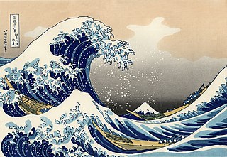
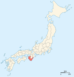
Kii Province, or Kishū (紀州), was a province of Japan in the part of Honshū that is today Wakayama Prefecture, as well as the southern part of Mie Prefecture. Kii bordered Ise, Izumi, Kawachi, Shima, and Yamato Provinces. The Kii Peninsula takes its name from this province.

Kii Peninsula

The Kii Peninsula is the largest peninsula on the island of Honshū in Japan. It is named after the ancient Kii Province.

Hirado Castle Japanese castle in Hirado, Nagasaki prefecture

Hirado Castle was the seat of the Matsura clan, the daimyō of Hirado Domain, of Hizen Province, Kyūshū. It is located in present-day Hirado city Nagasaki Prefecture, Japan. It was also known as Kameoka Castle.

The Wakayamakō Line is a railway line operated by Japanese private railway company Nankai Electric Railway that runs in Wakayama, Wakayama Prefecture, between Wakayamashi and Wakayamakō stations.

Echizen, Fukui City in Chūbu, Japan

Echizen is a city located in Fukui Prefecture, Japan. As of 1 July 2018, the city had an estimated population of 83,078 in 20.341 households and the population density of 360 persons per km². The total area of the city was 230.70 square kilometres (89.07 sq mi). The modern city of Echizen was established on October 1, 2005, from the merger of the city of Takefu and the town of Imadate ; although the Echizen Basin has been an important regional center for over 1,500 years. The city is home to the largest number of cultural assets in Fukui Prefecture and has many former castle sites and prehistoric archeological sites.

Gosanke

The Tokugawa Gosanke, also called simply Gosanke, or even Sanke, were the most noble three branches of the Tokugawa clan of Japan: Owari House of Tokugawa, Kii House of Tokugawa, and Mito House of Tokugawa, all of which were descended from clan founder Tokugawa Ieyasu's three youngest sons, Yoshinao, Yorinobu, and Yorifusa, and were allowed to provide a shōgun in case of need. In the Edo period the term gosanke could also refer to various other combinations of Tokugawa houses, including (1) the shogunal, Owari and Kii houses and (2) the Owari, Kii, and Suruga houses.

Wakayama Station railway station in Wakayama, Wakayama prefecture, Japan

Wakayama Station is a railway station in Wakayama, Wakayama Prefecture, Japan, jointly operated by the West Japan Railway Company and the Wakayama Electric Railway.

Matsue Core city in Chūgoku, Japan

Matsue is the capital city of Shimane Prefecture, Japan, located in the Chūgoku region of Honshu.

Tsuyama Domain Japanese historical estate in Mimasaka province

Tsuyama Domain was a Japanese domain of the Edo period. It was associated with Mimasaka Province in modern-day Okayama Prefecture.

Kishū Domain Japanese historical estate in Kii province

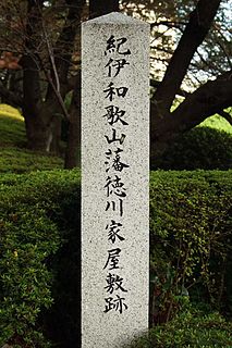
The Kishū Domain, also known as Kii Domain (紀伊藩) or Wakayama Domain (和歌山藩), was a han or Japanese feudal domain in Kii Province. The domain spanned areas of present-day Wakayama and southern Mie prefectures, and had an income of 555,000 koku. The domain was administered from Wakayama Castle in present-day Wakayama, Wakayama Prefecture. The heads of the domain were drawn from the Kishu-Tokugawa clan, one of the Gosanke, or three branches of the Tokugawa clan. The domain was founded by Tokugawa Yorinobu, the tenth son of the shōgun Tokugawa Ieyasu, when he moved from Sunpu Domain in Suruga Province to Kii Province. The Kishū came to control the smaller adjacent Tanabe and Shingū domains. The Kishū Domain was noted for its production of the Kishū mikan, soy sauce, lacquerware, and high-grade oak charcoal during the Edo period, and leather and cotton production by the Meiji Restoration in 1868.

Matsusaka Castle building in Matsusaka, Mie Prefecture, Japan

Matsusaka Castle was a Japanese castle located in Matsusaka, Mie Prefecture, Japan. Throughout most of the Edo period, Matsusaka Castle was a secondary administrative center for the Kishu-Tokugawa clan, daimyō of Kishū Domain. The site has been proclaimed a National Historic Site by the Japanese government.

Wakayamashi Station railway station in Wakayama, Wakayama Prefecture, Japan

Wakayamashi Station is a railway station in Wakayama, Wakayama Prefecture, Japan. To distinguish it from Wakayama Station, the station is called "City Station".

Wakayamakō Station railway station in Wakayama, Wakayama prefecture, Japan

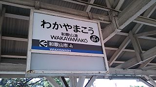
Wakayamakō Station is a railway station in Wakayama, Wakayama Prefecture, Japan, operated by the private railway operator Nankai Electric Railway.

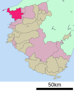
Wakayama 3rd district is a constituency of the House of Representatives in the Diet of Japan. It is located in Wakayama Prefecture and consists of Arida, Gobo, Shingu, and Tanabe cities and the Arida, Hidaka, Higashimuro, and Nishimuro districts. As of 2012, 298,296 eligible voters were registered in the district.

Wakayamadaigakumae Station railway station in Wakayama, Wakayama prefecture, Japan

Wakayamadaigakumae Station is a train station on the Nankai Main Line in the city of Wakayama, Wakayama Prefecture, Japan, operated by the private railway operator Nankai Electric Railway. It serves Wakayama University.

Wakayama Prefectural Museum

Wakayama Prefectural Museum is a museum in Wakayama, Japan. It is one of Japan's many museums which are supported by a prefecture.

Mount Izumi Katsuragi mountain in Japan

Mount Izumi Katsuragi is a mountain in the Kongō Range straddling the border between Osaka and Wakayama Prefectures in Japan. Its peak elevation is 858 metres (2,815 ft).

References

  1. Johnson, Bobbie (13 November 2007). "Japan's melody roads play music as you drive". The Guardian . Farringdon Road, London, England: GMG. p. 19 (International section). Retrieved 20 October 2008.
  2. "Your car as a musical instrument - Melody Roads". Noise Addicts. 29 September 2008. Retrieved 20 October 2008.
  3. "Wakayama Climate Normals 1961-1990". National Oceanic and Atmospheric Administration . Retrieved January 6, 2013.
  4. "Archived copy". Archived from the original on 23 September 2015. Retrieved 26 August 2015.
  5. "ウリハッキョ一覧" (Archive). Chongryon. Retrieved on October 14, 2015.
  6. "Archived copy". Archived from the original on 2011-02-20. Retrieved 2011-02-19.