Hiratsuka, Kanagawa

Last updated
Hiratsuka
平塚市
Special city
Hiratsuka -01.jpg
Hiratsuka City
Flag of Hiratsuka, Kanagawa.svg
Flag
Shen Nai Chuan Xian Ping Zhong Shi Shi Zhang .svg
Seal
Hiratsuka in Kanagawa Prefecture Ja.svg
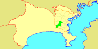
Location of Hiratsuka in Kanagawa Prefecture
Japan location map with side map of the Ryukyu Islands.svg
Red pog.svg
Hiratsuka
 
Coordinates: 35°19′N139°21′E / 35.317°N 139.350°E / 35.317; 139.350 Coordinates: 35°19′N139°21′E / 35.317°N 139.350°E / 35.317; 139.350
Country Japan
Region Kantō
Prefecture Kanagawa Prefecture
Government
  Mayor Katsuhiro Ochiai (since May 2011)
Area
  Total 67.88 km2 (26.21 sq mi)
Population (April 1, 2017)
  Total 257,877
  Density 3,800/km2 (9,800/sq mi)
Time zone UTC+9 (Japan Standard Time)
- Tree Camphor Laurel
- Flower Dianthus
- Bird Egret
Phone number 0463-23-1111
Address 9-1 Sengenchō, Hiratsuka-shi, Kanagawa-ken 254-8686
Website www.city.hiratsuka.kanagawa.jp

Hiratsuka(平塚市,Hiratsuka-shi) is a city located in Kanagawa Prefecture, Japan.

Cities of Japan administrative division of Japan

A city is a local administrative unit in Japan. Cities are ranked on the same level as towns and villages, with the difference that they are not a component of districts. Like other contemporary administrative units, they are defined by the Local Autonomy Law of 1947.

Kanagawa Prefecture Prefecture of Japan

Kanagawa Prefecture is a prefecture located in Kantō region of Japan. The capital of the prefecture is Yokohama. Kanagawa is part of the Greater Tokyo Area. Kanagawa Prefecture is home to Kamakura and Hakone, two popular side trip destinations from Tokyo.

Japan Constitutional monarchy in East Asia

Japan is an island country in East Asia. Located in the Pacific Ocean, it lies off the eastern coast of the Asian continent and stretches from the Sea of Okhotsk in the north to the East China Sea and the Philippine Sea in the south.

Contents

As of April 1, 2017, the city has an estimated population of 257,877, with 109,020 households, [1] and a population density of 3,800 persons per km². The total area is 67.88 km². [2]

Population All the organisms of a given species that live in the specified region

In biology, a population is all the organisms of the same group or species, which live in a particular geographical area, and have the capability of interbreeding. The area of a sexual population is the area where inter-breeding is potentially possible between any pair within the area, and where the probability of interbreeding is greater than the probability of cross-breeding with individuals from other areas.

Household group of one or more people living in the same dwelling and sharing meals or living accommodation; may consist of a single family or other grouping of people

A household consists of one people who live in the same dwelling and share meals. It may also consist of a single family or another group of people. A dwelling is considered to contain multiple households if meals or living spaces are not shared. The household is the basic unit of analysis in many social, microeconomic and government models, and is important to economics and inheritance.

Population density A measurement of population numbers per unit area or volume

Population density is a measurement of population per unit area or unit volume; it is a quantity of type number density. It is frequently applied to living organisms, and most of the time to humans. It is a key geographical term. In simple terms population density refers to the number of people living in an area per kilometer square.

Geography

Hiratsuka is located on the western Kantō Plain midway between Tokyo and Mount Fuji, and has a 5-kilometer coastline in the Shōnan area on the Pacific Ocean in Sagami Bay.

Kantō Plain plain

The Kantō Plain is the largest plain in Japan, and is located in the Kantō region of central Honshū. The total area 17,000 km2 covers more than half of the region extending over Tokyo, Saitama Prefecture, Kanagawa Prefecture, Chiba Prefecture, Gunma Prefecture, Tochigi Prefecture and Ibaraki Prefecture.

Tokyo Metropolis in Kantō

Tokyo, officially Tokyo Metropolis, one of the 47 prefectures of Japan, has served as the Japanese capital since 1869. As of 2018, the Greater Tokyo Area ranked as the most populous metropolitan area in the world. The urban area houses the seat of the Emperor of Japan, of the Japanese government and of the National Diet. Tokyo forms part of the Kantō region on the southeastern side of Japan's main island, Honshu, and includes the Izu Islands and Ogasawara Islands. Tokyo was formerly named Edo when Shōgun Tokugawa Ieyasu made the city his headquarters in 1603. It became the capital after Emperor Meiji moved his seat to the city from Kyoto in 1868; at that time Edo was renamed Tokyo. Tokyo Metropolis formed in 1943 from the merger of the former Tokyo Prefecture and the city of Tokyo. Tokyo is often referred to as a city but is officially known and governed as a "metropolitan prefecture", which differs from and combines elements of a city and a prefecture, a characteristic unique to Tokyo.

Mount Fuji Volcano in Yamanashi and Shizuoka Prefectures, Japan

Mount Fuji, located on Honshū, is the highest volcano in Japan at 3,776.24 m (12,389 ft), 2nd-highest peak of an island (volcanic) in Asia, and 7th-highest peak of an island in the world. It is a dormant stratovolcano that last erupted in 1707–1708. Mount Fuji lies about 100 kilometers (60 mi) south-west of Tokyo, and can be seen from there on a clear day. Mount Fuji's exceptionally symmetrical cone, which is snow-capped for about 5 months a year, is a well-known symbol of Japan and it is frequently depicted in art and photographs, as well as visited by sightseers and climbers.

Surrounding municipalities
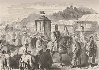
Chigasaki, Kanagawa Special city in Kantō, Japan

Chigasaki is a city located in Kanagawa Prefecture, Japan.

Hadano, Kanagawa City in Kantō, Japan

Hadano is a city in Kanagawa Prefecture, Japan.

History

The area around Hiratsuka has been settled since prehistoric times, and mention of the area as part of ancient Ōsumi District, Sagami Province is found in Nara period records. From the Heian period through Kamakura period, the area was divided into shōen controlled by various samurai clans and in the Sengoku period was the site of several battles between the later Hōjō clan of Odawara and the Miura clan. After the defeat of the Hōjō at the Battle of Odawara by Toyotomi Hideyoshi, the area came under the control of Tokugawa Ieyasu, who built a summer palace (the Nakahara Goten) in 1596 at the site now occupied by the Hiratsuka City Nakahara Elementary/Primary School. Hiratsuka was retained as tenryō territory after the establishment of the Tokugawa shogunate, and flourished as Hiratsuka-juku, a post town on the Tōkaidō connecting Edo with Kyoto. As the 7th station, it is often depicted in the series of ukiyo-e about the 53 Stations of the Tōkaidō made among others by artists such Hokusai and Hiroshige.

Sagami Province province of Japan

Sagami Province was a province of Japan located in what is today the central and western Kanagawa Prefecture. Sagami bordered on Izu, Musashi, Suruga Provinces; and had access to the Pacific Ocean through Sagami Bay. However, most of the present-day cities of Yokohama and Kawasaki, now part of Kanagawa Prefecture, were not in Sagami, but rather, in Musashi Province. Its abbreviated form name was Sōshū (相州).

Nara period historical period of Japan (AD 710 to 794), starting from when Empress Genmei established the capital of Heijō-kyō (present-day Nara).

The Nara period of the history of Japan covers the years from AD 710 to 794. Empress Genmei established the capital of Heijō-kyō. Except for a five-year period (740–745), when the capital was briefly moved again, it remained the capital of Japanese civilization until Emperor Kanmu established a new capital, Nagaoka-kyō, in 784, before moving to Heian-kyō, modern Kyoto, a decade later in 794.

Heian period last major division of classical Japanese history (794 to 1185), named after the capital city of Heian-kyō, or modern Kyōto

The Heian period is the last division of classical Japanese history, running from 794 to 1185. The period is named after the capital city of Heian-kyō, or modern Kyōto. It is the period in Japanese history when Buddhism, Taoism and other Chinese influences were at their height. The Heian period is also considered the peak of the Japanese imperial court and noted for its art, especially poetry and literature. Although the Imperial House of Japan had power on the surface, the real power was in the hands of the Fujiwara clan, a powerful aristocratic family who had intermarried with the imperial family. Many emperors actually had mothers from the Fujiwara family. Heian (平安) means "peace" in Japanese.

After the Meiji Restoration, Hiratsuka town was founded on April 1, 1889, as part of the new Naka District within Kanagawa Prefecture. It merged with neighboring Suma Town on April 1, 1929, and was proclaimed Hiratsuka City on April 1, 1932.

Meiji Restoration restoration of imperial rule in Japan

The Meiji Restoration, also known as the Meiji Renovation, Revolution, Reform, or Renewal, was an event that restored practical imperial rule to the Empire of Japan in 1868 under Emperor Meiji. Although there were ruling emperors before the Meiji Restoration, the events restored practical abilities and consolidated the political system under the emperor of Japan.

Naka District, Kanagawa administrative district of Japan located in Kanagawa Prefecture

Naka District is a district located in central Kanagawa Prefecture, Japan. It currently consists of two towns, Ōiso, and Ninomiya. The majority of the area of the city of Hadano and the entire cities of Hiratsuka and Isehara were formerly part of Naka District.

Prior to World War II, Hiratsuka was the location of the Hiratsuka Navy Ammunitions Arsenal (平塚海軍火薬廠) of the Imperial Japanese Navy and Japan International Aircraft Industries (日本国際航空工業), a Nissan group military aircraft factory. Hiratsuka was largely destroyed on July 16, 1945, during the Bombing of Hiratsuka in World War II. Due to its strategic location and wide beaches, it was also one of the targets for the planned invasion of Japan during the final stages of World War II.

The city quickly rebuilt after the war, annexing several neighboring villages in the mid-1950s to attain its current area. The population exceeded 200,000 by 2001 and Hiratsuka became a special city with increased autonomy from the central government. The current mayor is the independent OCHIAI Katsuhiro (落合克宏) who was elected April 24, 2011, and assumed office on April 30. Previously he had served two terms on the Hiratsuka city council and as council chairperson for the majority of the second term. OCHIAI succeeded Ritsuko ÔKURA the city's first female mayor who served from 2003 to 2011.

Economy

Hiratsuka has a mixed economy, with tax revenue coming from wagers made at Shonan Bank Cycling Velodrome, and several industries located in industrial parks in the outskirts of town. Major plants are operated by Nissan Shatai, Yokohama Rubber Company, Canon, Furukawa Electric, Pilot (pen company) (the famous Namiki pens are produced at Kiratsuka), Kansai Paint, and Mitsubishi Plastics. Nissan Shatai produced the largest employment on the City, but announced the plan to let a factory move to Kanda. Western firms such as Moog and MacDermid Performance Solutions also have a strong presence in this city. [3] Hiratsuka is also a bedroom community for Yokohama and Tokyo, with residents attracted by the "Shōnan lifestyle".

Transportation

Railway

Highway

Tourist attractions

Hiratsuka Tanabata festival Hiratsuka Tanabata 2008 daytime-1.jpg
Hiratsuka Tanabata festival

Sister cities

Notable people from Hiratsuka

Related Research Articles

Sagami Bay bay in Japan

Sagami Bay lies south of Kanagawa Prefecture in Honshu, central Japan, contained within the scope of the Miura Peninsula, in Kanagawa, to the east, the Izu Peninsula, in Shizuoka Prefecture, to the west, and the Shōnan coastline to the north, while the island of Izu Ōshima marks the southern extent of the bay. It lies approximately 40 kilometres (25 mi) southwest of the capital, Tokyo. Cities on the bay include Odawara, Chigasaki, Fujisawa, Hiratsuka, Itō, and Kamakura.

Fujisawa, Kanagawa City in Kantō, Japan

Fujisawa is a city in Kanagawa Prefecture, Japan.

Odakyu Electric Railway Co., Ltd., or OER, is a major railway company based in Tokyo, Japan, best known for its Romancecar series of limited express trains from Tokyo to Odawara, Enoshima, Tama New Town, and Hakone.

Sagamihara Designated city in Kantō, Japan

Sagamihara is a city in Kanagawa Prefecture, Japan. It is the third most populous city in the prefecture, after Yokohama and Kawasaki, and the fifth most populous suburb of the Greater Tokyo Area. Its northern neighbor is Machida, with which a cross-prefectural merger has been proposed.

Isehara, Kanagawa City in Kantō, Japan

Isehara is a city located in Kanagawa Prefecture, Japan.

Ebina, Kanagawa City in Kantō, Japan

Ebina is a city located in Kanagawa Prefecture, Japan.

Ninomiya, Kanagawa Town in Kantō, Japan

Ninomiya is a town located in Kanagawa Prefecture, Japan. As of June 2012, the town had an estimated population of 29,350, and a density of 3,230 persons per km2. The total area is 9.08 km2.

Ōiso, Kanagawa Town in Kantō, Japan

Ōiso is a town located in Kanagawa Prefecture, Japan. As of June 2012, the town had an estimated population of 32,786, and a density of 1,910 people per km2. The total area is 17.18 km2.

Manazuru, Kanagawa Town in Kantō, Japan

Manazuru is a town located in Kanagawa Prefecture, Japan. As of June 1 2012, the town had an estimated population of 7,926, and a population density of 1,130 persons per km². The total area is 7.02 km².

Yugawara Town in Kantō, Japan

Yugawara is a town located in Kanagawa Prefecture, Japan. As of June 1, 2012, the town had an estimated population of 26,474, and a population density of 646 persons per km2. The total area is 40.99 km2.

Hodogaya-ku, Yokohama Ward in Kantō, Japan

Hodogaya-ku (保土ケ谷区) is one of the 18 wards of the city of Yokohama in Kanagawa Prefecture, Japan. As of 2010, Hodogaya Ward had an estimated population of 205,887 and a density of 9,400 inhabitants per square kilometer (24,000/sq mi). The total area was 21.91 km2 (8.46 sq mi).

Seya-ku, Yokohama Ward in Kantō, Japan

Seya-ku (瀬谷区) is one of the 18 wards of the city of Yokohama in Kanagawa Prefecture, Japan. As of 2010, the ward had an estimated population of 126,839 and a density of 7,390 persons per km2. The total area was 17.16 km2.

Totsuka-ku, Yokohama Ward in Kantō, Japan

Totsuka-ku (戸塚区) is one of the 18 wards of the city of Yokohama in Kanagawa Prefecture, Japan. As of 2010, the ward had an estimated population of 273,418 and a density of 7,640 persons per km². The total area was 35.70 km².

The Kanagawa Prefectural Board of Education (神奈川県教育委員会) is the board of education for Kanagawa Prefecture in Japan. The board consists of six members; one of them is elected as the chair, and one of them is appointed by the board as the superintendent. The board administers municipal education and directly operates all of the prefectural schools.

Odawara Special city in Kantō, Japan

Odawara is a city in Kanagawa Prefecture, Japan.

Totsuka-juku

Totsuka-juku was the fifth of the fifty-three stations (shukuba) of the Tōkaidō. It was the eastern-most post station in Sagami Province. It is now located in Totsuka-ku in the present-day city of Yokohama, Kanagawa Prefecture, Japan.

References

  1. "Statistics of Hiratsuka City" (in Japanese). Japan: Hiratsuka City. Retrieved 6 May 2017.
  2. Hiratsuka City Hall (ed.). "Hiratsuka-shi Statistical Documentation" (PDF). Retrieved March 11, 2016.
  3. "MacDermid Performance Solutions Completes Major Expansion of Japan Facility". Yahoo! Finance . 4 November 2016. Retrieved 2017-06-29. MacDermid Performance Solutions’ state-of-the-art R&D facility is located in Hiratsuka City and now equipped with enhanced capabilities to accommodate the changing requirements of Japanese customers of both plating chemistry and assembly materials.