Victoria Park railway station (England)

Last updated

Victoria Park
Location Hackney Wick
Owner North London Railway
Number of platforms3
Key dates
14 June 1856 (1856-06-14)Opened
8 November 1943 (1943-11-08)Closed
Other information
Underground sign at Westminster.jpg  London transportportal

Victoria Park (opened as Victoria Park & Hackney Wick) [1] was a railway station near Victoria Park, east London, [2] that was on the North London Railway (NLR) which opened in September 1850 to Bow (where the trains turned east into the London and Blackwall Railway's Fenchurch Street station) and to the London Docks in January 1852.

A line linking the NLR line to the Eastern Counties Railway (ECR) at Stratford was built with a junction east of the first station site in 1854, and two years after that the first station opened with a station building in Wick Road. At the time the station was between Hackney and Bow on the north London Railway with other stations opening later,

The original station was replaced in March 1866 by a larger station at the junction itself to cope with increased passenger numbers and this station lasted until closure in 1943. The Wick Rad buildings became two residential properties and these survived until 1958.

The second station building survived until 1970 when it was demolished to make way for a new road scheme and there are no remains today.

Railway Clearing House diagram showing the station top left Bow, Bromley, Forest Gate, Hackney Wick or Victoria Park, Stratford & Woodgrange Park RJD 98.jpg
Railway Clearing House diagram showing the station top left

Description

The first station was located west of the later junction with what is now the North London Line and consisted of a two-storey brick station building with two short platforms. It was of brick construction and was located in Wick Road.

The second station, which is shown on the attached map, was located at the new junction. Initially it had four platforms - two for the Poplar line and two for the Stratford line. The eastbound (towards Stratford) platform did not last for long once through trains had been withdrawn and the station spent most of its existence with three operational platforms.

The three storey station building was of brick construction. It was located on Cadogan Terrace between the two sets of lines and had a small forecourt behind railings. The railway was on an embankment at this location and the station building consisted of offices and stairs to track level. A subway linked the three platforms - the fourth being accessed by a board crossing across the tracks. A photograph from 1900 shows curtains in the top floor windows indicating this may have been a residence for the station master rather than offices.

A signal box was located north and adjacent to the junction. This was replaced by a signal box in 1961 on the site of the former platforms between the two sets of running lines. [3]

History

Pre-grouping (1850-1922)

The East & West India Docks & Birmingham Junction Railway (known as the North London Railway (NLR)) from 1853 was incorporated by Act of Parliament on 26 August 1846. It was empowered to construct a railway from the district of Poplar and the docks to Camden Town in north London. [4]

Passenger services started operating between Islington, Bow and Fenchurch Street station on 26 September 1850 with goods services to Poplar and the docks commencing on 1 January 1852.

The line between Victoria Park and Stratford was opened on 15 August 1854 by the Eastern Counties Railway (ECR) and the North London Railway began operating regular goods services early the following year. The passenger trains (towards Fenchurch Street/Stratford) had additional carriages which were detached at the junction and a second locomotive worked them through to Stratford. In the opposite direction the coaches were attached.

The first station was provided west of the junction with two platforms Although not quite complete the station opened temporarily to passengers on 29 May 1856 in conjunction with a special event celebrating the end of the Crimean War. Full opening was on 14 June 1856.

The North London Railway ran two return trains per day from Hampstead Road (later renamed Chalk Farm) via Victoria Park and Forest Gate Junctions to Tilbury which commenced on 1 July 1855 and finished 30 September. Congestion at Stratford made making these short lived services difficult and one was involved in an accident during this time at Stratford although a further attempt (as far as Barking) was made during September and October 1866 [5]

The practice of attaching and detaching carriages (now at the station) continued until a shuttle services was introduced from 1 January 1860.

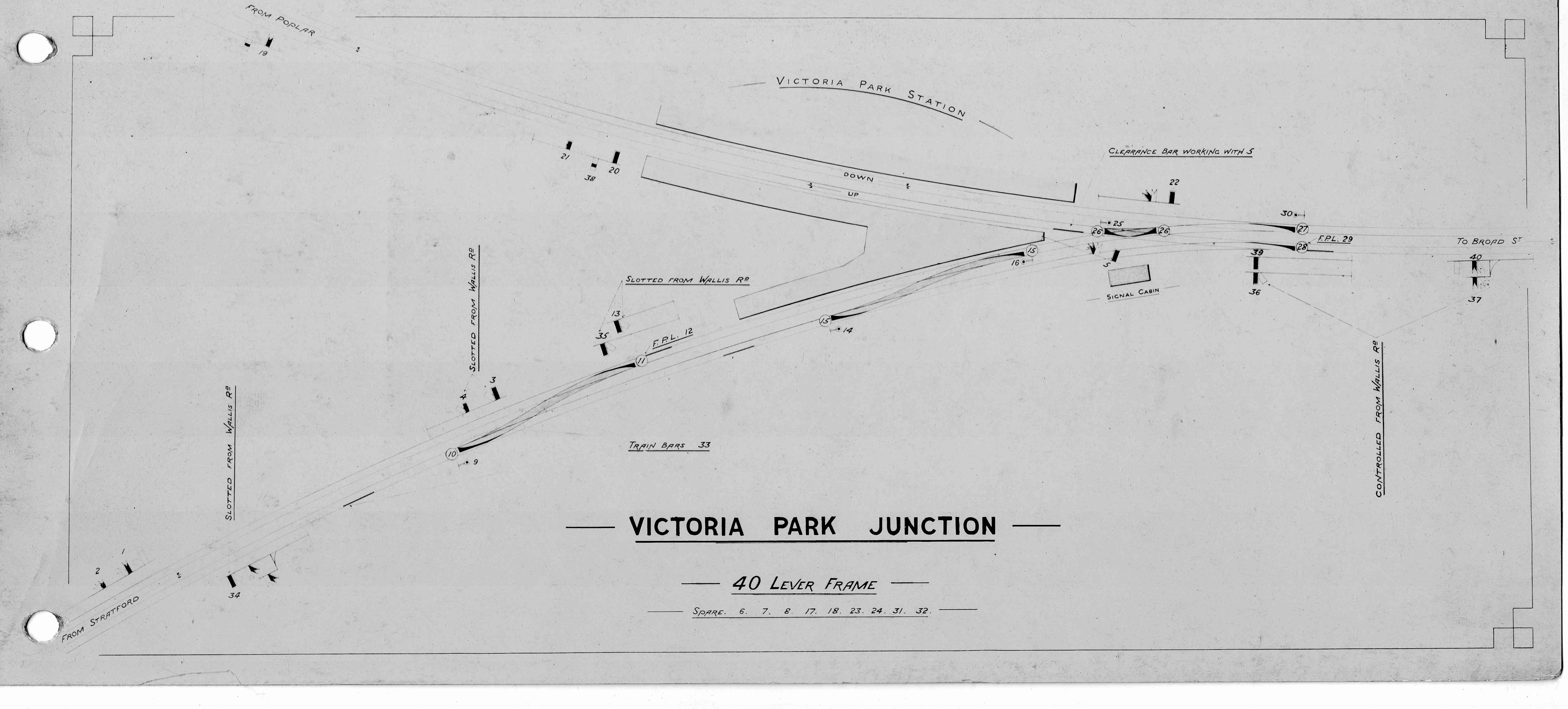
This operational complexity as well as the growing popularity of Victoria Park, Hackney as a leisure destination saw a need to improve on the existing facilities and the second station situation south east of the original station (this is shown on the accompanying map) was opened 1 March 1866. Initially it had four platforms but the local used the westbound platform to terminate and originate and the east bound platform was used by the through trains to Barking. Once these ceased the platform, was rarely used and had been removed by 1895. [6]

The ECR became part of the Great Eastern Railway (GER) in 1862.

A shuttle service operated from the eastbound platform to Stratford Bridge station from 1 September 1866 and was operated by the Great Eastern Railway (GER) and North London Railway in alternate years up until 31 October 1874. [7]

After that operation was taken over by the GER and from 1 October 1895 services ran through to Canning Town and occasionally North Woolwich.

A footbridge linking the three platforms was opened on 24 February 1891 to support the existing subway. On 11 February 1899 a second entrance from Riseholme Street (to the Broad Street platform) was opened. [8]

The London & North Western Railway (LNWR) took over the working of the North London Railway under a common management arrangement on 1 February 1909 although the North London Railway continued to exist until 1922. [9]

During World War I the half hourly service was reduced to hourly and further cuts followed in 1921.

London Midland & Scottish Railway (1923-1943)

Following the Railways Act 1921, also known as the grouping act, operation of the station fell under the control of the London Midland & Scottish Railway. Trains formerly operated by the Great Eastern Railway were now operated by the London and North Eastern Railway (LNER).

LMS Sunday services to Poplar were withdrawn on 29 January 1940. [10]

On 20 March 1941 the station suffered some minor bomb damage from a German air raid. [11]

The LNER Sunday service to Canning Town was withdrawn on 31 March 1940 and withdrawal of the weekday service followed on 1 November 1942. With the interchange facility lost and declining passenger numbers the decision was taken to close Victoria Park station and closure took place on 8 November 1943.

After closure

The passenger service between Broad Street and Poplar (East India Road) was withdrawn due to bomb damage in May 1944 on the route during World War II and the fact that passenger numbers had been declining since the early part of the century. The line remained open to goods for the docks.

After closure the waiting room on the Broad Street platform became a base for the local Home Guard. [12]

The footbridge was demolished in 1950.

The station building from the first station which had been used as a pair of residential properties was demolished in 1958.

The platforms were demolished at some point in the early 1960s but the former station building survived until 1970 when it was demolished as part of the construction of the East Cross Route (formerly the A102(M) but now the A12) with a new railway viaduct on the Poplar line crossing the new road constructed c.1972 [13]

The track to Stratford was put into revived passenger use from 14 May 1979 (marketed as the Crosstown Linkline) and Hackney Wick station opened a short distance to the east on 12 May 1980. [14]

The Poplar line closed to all rail traffic on 3 October 1983 with the track being lifted during May 1984. [15]

Services on the North London Line have gone from strength to strength since the re-opening of the "Cross London Link" with electrification and services running between Richmond and North Woolwich (1985-2006) and Clapham Junction or Richmond to Stratford (the 2021 service), The line sees heavy freight usage being the only electrified route between the major east coast Port of Felixstowe and the West Coast Main Line. Nothing remains of the station today except the bottom floor of the 1961 signal box which houses electrical equipment. [16]

Related Research Articles

<span class="mw-page-title-main">North London line</span> Railway line in London

The North London line (NLL) is a railway line which passes through the inner suburbs of west, north-west, north, and north-east London, England between Richmond in the south-west and Stratford in the east, avoiding central London. Its route is a rough semicircle.

<span class="mw-page-title-main">Fenchurch Street railway station</span> Railway terminus in the City of London

Fenchurch Street railway station, also known as London Fenchurch Street, is a central London railway terminus in the southeastern corner of the City of London. It takes its name from its proximity to Fenchurch Street, a key thoroughfare in the City. The station and all trains are operated by c2c. Services run on lines built by the London and Blackwall Railway (L&BR) and the London, Tilbury and Southend Railway (LTSR) are to destinations in east London and south Essex, including Upminster, Grays, Basildon, Southend and Shoeburyness.

<span class="mw-page-title-main">Stratford station</span> London Underground, Docklands Light Railway and National rail station

Stratford is a major multi-level interchange station serving the district of Stratford and the mixed-use development known as Stratford City, in the London Borough of Newham, East London for London Underground, London Overground, Docklands Light Railway (DLR) and Elizabeth line services. National Rail services also operate on the West Anglia Main Line and the Great Eastern Main Line, 4 miles 3 chains (6.5 km) from Liverpool Street.

<span class="mw-page-title-main">Custom House station</span> Railway and DLR station in London

Custom House is an interchange station by the Royal Docks, in Custom House in the London Borough of Newham, London for Docklands Light Railway (DLR) – on which it is branded Custom House for ExCeL – and Elizabeth line services. It is situated in Travelcard Zone 3.

<span class="mw-page-title-main">London, Tilbury and Southend line</span> Commuter railway line in Essex, England

The London, Tilbury and Southend line, also known as Essex Thameside, is a commuter railway line on the British railway system. It connects Fenchurch Street station, in central London, with destinations in east London and Essex, including Barking, Upminster, Basildon, Grays, Tilbury, Southend and Shoeburyness.

The North London Railway (NLR) company had lines connecting the northern suburbs of London with the East and West India Docks further east. The main east to west route is now part of London Overground's North London Line. Other NLR lines fell into disuse but were later revived as part of the Docklands Light Railway, and London Overground's East London Line. The company was originally called the East & West India Docks & Birmingham Junction Railway (E&WID&BJR) from its start in 1850, until 1853. In 1909, it entered into an agreement with the London and North Western Railway which introduced common management, and the NLR was taken over completely by the LNWR in 1922. The LNWR itself became part of the LMS from the start of 1923. The railways were nationalised in 1948 and most LMS lines, including the North London route, then came under the control of the London Midland Region of British Railways.

<span class="mw-page-title-main">Bow Road railway station</span> Disused railway station in England

Bow Road is a closed railway station in Bow, East London, that was opened in 1876 on the Bow Curve branch line by the Great Eastern Railway (GER).

<span class="mw-page-title-main">Shoreditch railway station</span> Former railway station in England

Shoreditch was a railway station on the North London Railway (NLR) in Shoreditch, London, that was in use from 1865 to 1940. It was situated on a viaduct between Haggerston and Broad Street stations. It should not be confused with Shoreditch Underground station (1869–2006) on the London Underground, situated about half a mile further south. It was also not the first main line railway station to possess the Shoreditch name; Bishopsgate (1840–1875) was originally given that name.

<span class="mw-page-title-main">Hackney Wick railway station</span> Railway station in London, England

Hackney Wick is a station on the North London Line in the area of Hackney Wick, East London. It is in Travelcard Zone 2. The station and all trains serving it are operated by London Overground. It opened on 12 May 1980 by British Rail as part of the Crosstown Linkline service between North Woolwich and Camden Road stations. Between Spring 2017 and May 2018 the station was rebuilt and modernised, including replacement of the footbridge by a subway. The new subway, in addition to linking the two platforms will, later in 2018, provide a cycle and pedestrian link between Hackney and Tower Hamlets.

<span class="mw-page-title-main">Dalston Junction railway station</span> Railway station in London, England

Dalston Junction is an inter-modal rail and bus transport interchange in Dalston, London. It is located at the crossroads of Dalston Lane, Kingsland Road and Balls Pond Road. The station served by London Overground East London line and is in Zone 2. The station is located in a short section of cut and cover tunnel north of the Kingsland Viaduct.

<span class="mw-page-title-main">Bow railway station</span> Disused railway station in England

Bow was a railway station in Bow, east London, that was opened in 1850 by the East & West India Docks and Birmingham Junction Railway, which was later renamed the North London Railway (NLR). The station was situated between Old Ford and South Bromley, and was located on the north side of Bow Road, close to the second Bow Road station which was open from 1892 to 1949. A covered footway connected the two stations between 1892 and 1917.

Old Ford was a railway station in Old Ford, north of Bow, in east London. The railway through the site was opened on 26 September 1850 by the East & West India Docks & Birmingham Junction Railway which was renamed in 1853 as the North London Railway (NLR), It was not until 1 July 1867 that Old Ford station opened. It was situated between Victoria Park and Bow, and was located on Old Ford Road, east of the junction with Lefevre Road.

<span class="mw-page-title-main">Haggerston railway station</span> London Overground station

Haggerston is a London Overground station in Haggerston, London, England, served by the East London line. It lies between Hoxton and Dalston Junction stations, is in Travelcard Zone 2, and is open 24 hours on a Friday and Saturday as part of the London Overground Night Service service. The station was rebuilt as part of the East London line extension.

South Bromley railway station was a former railway station in South Bromley, London, on the North London Railway between Bow and Poplar. It opened in 1884 but was closed in 1944 after bomb damage in the Blitz cut off the railway east of Dalston Junction.

Poplar (East India Road) was a railway station located on the East India Dock Road in Poplar, London. It was opened in 1866 by the North London Railway. It was the southern passenger terminus of the NLR, although goods trains ran on to connect to the London and Blackwall Railway (LBR) for the East India Docks or to the LBR's Millwall Extension Railway for the West India Docks.

<span class="mw-page-title-main">Poplar railway station</span> Former railway station in England

Poplar was a railway station in Poplar, London, that was opened in 1840 by the Commercial Railway and was situated between Millwall Junction and Blackwall, 3 miles 16 chains (5.1 km) down-line from Fenchurch Street. It was closed in 1926, at which time it was owned by the London and North Eastern Railway.

<span class="mw-page-title-main">Burdett Road railway station</span> Disused railway station in England

Burdett Road is a disused railway station located in Bow Common, east London. It was opened in 1871 by the Great Eastern Railway and closed in 1941.

Kingsland Viaduct is a railway viaduct about 2 miles (3 km) in length from Shoreditch to Dalston, wholly within the present London Borough of Hackney in east and north-east part of London. It was built in the 1860s, but was disused from 1986 until it was reopened to carry the London Overground in 2010. The viaduct is owned by Transport for London. Since then it has carried East London Line services between Shoreditch High Street and Dalston.

<span class="mw-page-title-main">North London Line City Branch</span>

The City Branch was a short spur of the North London Line allowing direct access from the east-west main route of the North London Railway to the terminus at Broad Street in the City of London.

Victoria Park & Bow was a short-lived railway station in Bow, east London. It was located close to the present-day Bow Junction on what is now the Great Eastern Main Line between Stratford and Bethnal Green. Built by the Eastern Counties Railway (ECR), it opened on 2 April 1849, seemingly for the main purpose of providing an interchange between the London and Blackwall Extension Railway's (LBER) Fenchurch Street branch and the ECR's main line between Bishopsgate and Stratford.

References

  1. Knott, George. "Trial of Franz Muller". 1911. Butterworth & Co (Internet Archive). Retrieved 17 February 2013.
  2. Catford, Nick. "Victoria Park (1st site)". Disused Stations Site Record. Nick Catford. Retrieved 17 February 2013.
  3. Connor, J E (2018). London's disused stations - the east end. Capital Transport Publishing. pp. 163/4. ISBN   978-1854144331.
  4. McCarthy, Colin; McCarthy, David (2009). Railways of Britain – London North of the Thames. Hersham, Surrey: Ian Allan Publishing. p. 6. ISBN   978-0-7110-3346-7.
  5. Borley, H V (1993). The memories and writings of a North London Railwayman. Mold, UK: Railway and Canal History Society. p. 77. ISBN   0-901461-16-4.
  6. Connor, J (2000). Branch Lines of East London. Midhurst UK: Middleton Press. p. 75. ISBN   1 901706 44 3.
  7. Borley, H V (1993). The memories and writings of a London railway man. Mold: Railway & Canal Historical Society. p. 76. ISBN   0-901461-16-4.
  8. Connor, J E (2018). London's disused stations - the east end. Capital Transport Publishing. p. 164. ISBN   978-1854144331.
  9. The National Archives, RAIL 529/32 – NLR Board Minute No 6940 of 14 January 1909
  10. Borley, H V (1993). The memories and writings of a London railway man. Mold: Railway & Canal Historical Society. pp. 76/77. ISBN   0-901461-16-4.
  11. Connor, J E (2018). London's disused stations - the east end. Capital Transport Publishing. p. 164. ISBN   978-1854144331.
  12. Connor, J E (2018). London's disused stations - the east end. Capital Transport Publishing. p. 164. ISBN   978-1854144331.
  13. Connor, J E (2018). London's disused stations - the east end. Capital Transport Publishing. p. 165. ISBN   978-1854144331.
  14. Salmon, S., Smith, P. (2019). Directory of British Railways: New and Reopened Stations 1948–2018. United Kingdom: Pen & Sword Books.
  15. Catford, Nick. "Poplar East India Dock Road". Disused stations. Nick Catford. Retrieved 9 June 2021.
  16. Catford, Nick. "Victoria Park second site". Disused stations. C Catford. Retrieved 7 July 2021.
Preceding station Disused railways Following station
Homerton   North London Railway
Broad Street - Poplar (East India Road)
  Old Ford
Terminus  Great Eastern Railway
Victoria Park to Canning Town/North Woolwich
  Stratford

51°32′38″N0°01′47″W / 51.5438°N 0.0296°W / 51.5438; -0.0296