
Sunshine Peak is a fourteen thousand foot mountain peak in the U.S. state of Colorado. It is located in the San Juan Mountains in Hinsdale County approximately 9 miles (14 km) south west of Lake City, and about 1 mile (1.6 km) south of Redcloud Peak. It rises on the north side of the Lake Fork of the Gunnison River.

Sharkstooth Peak is a 12,468-foot-elevation (3,800-meter) mountain summit in Montezuma County, Colorado.

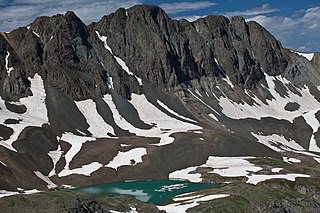
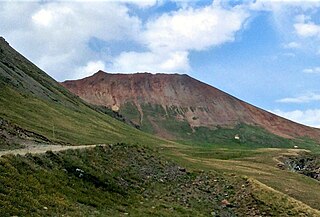
Precipice Peak is a 13,144-foot-elevation (4,006-meter) mountain summit located in Hinsdale County, of Colorado, United States. It is situated 10.5 miles northeast of the community of Ouray, in the Uncompahgre Wilderness, on land managed by Uncompahgre National Forest. It is part of the San Juan Mountains which is a subset of the Rocky Mountains, and is situated west of the Continental Divide. Topographic relief is significant as the west aspect rises 2,500 feet above the West Fork Cimarron River valley in approximately one mile. Neighbors include Dunsinane Mountain three-quarters of a mile north, Courthouse Mountain 2.4 miles northwest, and Redcliff 2.2 miles south. The mountain's name was officially adopted by the United States Board on Geographic Names in 1966. It is so named because of a very prominent precipice on the mountain's east face.
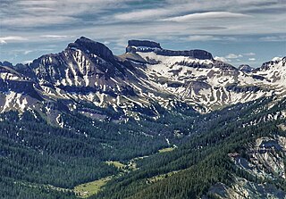
Coxcomb Peak is a 13,656-foot-elevation (4,162-meter) mountain summit located on the common boundary of Hinsdale County and Ouray County, in Colorado, United States. It is situated nine miles northeast of the community of Ouray, in the Uncompahgre Wilderness, on land managed by Uncompahgre National Forest. It is part of the San Juan Mountains which are a subset of the Rocky Mountains, and is situated west of the Continental Divide. Coxcomb ranks as the 171st-highest peak in Colorado, and topographic relief is significant as the south aspect rises 2,000 feet above Wetterhorn Basin in approximately one mile, and 4,400 feet above Cow Creek in three miles. Neighbors include Precipice Peak 2.7 miles to the north, Redcliff one-half mile north, Matterhorn Peak 2.3 miles to the east-southeast, and nearest higher neighbor Wetterhorn Peak 1.8 mile to the southeast. The mountain's descriptive name, which has been officially adopted by the United States Board on Geographic Names, was in use since at least 1906 when Henry Gannett published it in the Gazetteer of Colorado.
American Peak is a 13,806-foot-elevation (4,208-meter) mountain summit located in Hinsdale County, of southwest Colorado, United States.

Dunsinane Mountain, or officially Dunsinane, is a 12,742-foot-elevation (3,884-meter) mountain summit located in Hinsdale County, of Colorado, United States. It is situated 11 miles east of the community of Ridgway, in the Uncompahgre Wilderness, on land managed by Uncompahgre National Forest. It is part of the San Juan Mountains which are a subset of the Rocky Mountains, and is situated west of the Continental Divide. Topographic relief is significant as the east aspect rises 2,500 feet above the Middle Fork Cimarron River valley in approximately one mile. The mountain's name was officially adopted as Dunsinane by the United States Board on Geographic Names in 1966, and is so named because it resembles the castle Dunsinane of Shakespeare's Macbeth.

Redcliff is a 13,642-foot-elevation (4,158-meter) mountain summit located in Hinsdale County, in southwest Colorado, United States. It is situated nine miles northeast of the town of Ouray, in the Uncompahgre Wilderness, on land managed by Uncompahgre National Forest. It is part of the San Juan Mountains which are a subset of the Rocky Mountains, and is situated west of the Continental Divide. Redcliff ranks as the 175th-highest peak in Colorado, and topographic relief is significant as the west aspect rises 2,300 feet above the West Fork Cimarron River valley in approximately one mile. Neighbors include Precipice Peak and Dunsinane Mountain along the west-middle Cimarron divide three miles to the north, and nearest higher neighbor Coxcomb Peak one-half mile to the south. An ascent of Redcliff involves 3,300 feet of elevation gain and 10 miles of hiking, round-trip. The mountain's name was proposed by the Colorado Mountain Club, and was officially adopted in 1966 by the United States Board on Geographic Names. It is so named because of a large reddish-colored cliff on the mountain's east face.
Mount Nimbus is a 12,721-foot-elevation (3,877-meter) mountain summit in Grand County, Colorado, United States.

Carson Peak is a 13,662-foot-elevation (4,164-meter) summit in Hinsdale County, Colorado, United States.
Proposal Peak is a 13,339-foot-elevation (4,066-meter) mountain summit located in San Juan County, Colorado, United States.

Emery Peak is a 13,321-foot-elevation (4,060-meter) summit located in San Juan County, Colorado, United States.

Cinnamon Mountain is a 13,336-foot-elevation (4,065-meter) summit in San Juan County, Colorado, United States.

Sunshine Mountain is a 13,329-foot-elevation (4,063-meter) summit in Hinsdale County, Colorado, United States.

Little Giant Peak is a 13,417-foot-elevation (4,090-meter) mountain summit in San Juan County, Colorado, United States.

Kendall Peak is a 13,455-foot-elevation (4,101-meter) mountain summit in San Juan County, Colorado, United States.

Storm Peak is a 13,495-foot-elevation (4,113-meter) summit located in San Juan County, Colorado, United States.

Dome Mountain is a 13,379-foot-elevation (4,078-meter) summit located in San Juan County, Colorado, United States.
Wood Mountain is a 13,682-foot-elevation (4,170 meter) summit located on the boundary shared by Hinsdale County with San Juan County, in Colorado, United States.

A Peak is an 8,634-foot-elevation (2,632-meter) mountain summit located on the border shared by Lincoln and Sanders counties in Montana.

Sugarloaf Mountain is an 11,051-foot-elevation (3,368-meter) summit on the boundary that Salt Lake County shares with Utah County, in Utah, United States.


