| Bristol Head | |
|---|---|
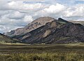
 Southwest aspect | |
| Highest point | |
| Elevation | 12,712 ft (3,875 m) [1] |
| Prominence | 1,201 ft (366 m) [1] |
| Parent peak | Table Mountain (12,867 ft) [1] |
| Isolation | 7.26 mi (11.68 km) [1] |
| Coordinates | 37°47′37″N107°03′18″W / 37.7935139°N 107.0549953°W [2] |
| Geography | |
 Bristol Head Location in Colorado  Bristol Head Bristol Head (the United States) | |
| Country | United States |
| State | Colorado |
| County | Mineral |
| Protected area | Rio Grande National Forest |
| Parent range | Rocky Mountains San Juan Mountains [3] |
| Topo map | USGS Bristol Head |
| Geology | |
| Rock age | Tertiary [4] |
| Rock type(s) | Dacitic lava, Breccia, Rhyolite [4] |
| Climbing | |
| Easiest route | class 1 hiking [1] |
Bristol Head is a 12,712-foot-elevation (3,875-meter) mountain summit in Mineral County, Colorado, United States.