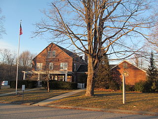
Pomfret is a town located in Windham County, Connecticut with a population of 4,266 according to the 2020 United States Census. The town is part of the Northeastern Connecticut Planning Region. The town was incorporated in 1713 and was named after Pontefract in West Yorkshire, England. The land on which Pomfret stands today was purchased from Native Americans in 1686 in a deal known as the "Mashmuket Purchase" or "Mashamoquet Purchase".

Chatfield Hollow State Park is a public recreation area occupying 412 acres (167 ha) that lie adjacent to Cockaponset State Forest in the town of Killingworth, Connecticut. The state park offers hiking trails, a swimming beach, trout fishing, mountain biking, rock climbing, and picnicking areas. Park attractions include 6.67-acre (2.70 ha) Schreeder Pond, Indian caves, historic sites, a restored water wheel, and a reproduction covered bridge. The park is managed by the Connecticut Department of Energy and Environmental Protection.
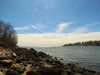
Rocky Neck State Park is a public recreation area on Long Island Sound in the town of East Lyme, Connecticut, United States. The state park's 708 acres (287 ha) include a tidal river, a broad salt marsh, white sand beaches, rocky shores, and a large stone pavilion dating from the 1930s. It is managed by the Connecticut Department of Energy and Environmental Protection.

Collis P. Huntington State Park is a public recreation area covering 1,017 acres (412 ha) in the towns of Redding, Newtown, and Bethel in Fairfield County, Connecticut. The state park is noted for Anna Hyatt Huntington's sculptures of bears and wolves that welcome visitors at the park entrance. Her work can also be seen in the heroic sculpture of General Israel Putnam at Putnam Memorial State Park in Redding. The park bears the name of railroad magnate Collis Potter Huntington, whose heirs donated the lands to the state. The park's web of multi-use trails is open to hikers, cyclists, and equestrians. The park is managed by the Connecticut Department of Energy and Environmental Protection.

Wadsworth Falls State Park, or simply Wadsworth Falls, is a public recreation and preserved natural area located on the Coginchaug River in the towns of Middletown and Middlefield, Connecticut. The state park's 285 acres (115 ha) offer trail hiking and fishing. Swimming and picnicking are allowed at the pond near the north entrance near 721 Wadsworth Street in Middletown. It is managed by the Connecticut Department of Energy and Environmental Protection.

Putnam Memorial State Park is a history-oriented public recreation area in the town of Redding, Connecticut. The state park preserves the site that Major General Israel Putnam chose as the winter encampment for his men in the winter of 1778/1779 during the American Revolutionary War. It is Connecticut's oldest state park, created in 1887 at the instigation of Redding town residents. The park was listed on the National Register of Historic Places in 1970.

Putnam Cottage was also known as Knapp Tavern during the American Revolution. It is located at 243 East Putnam Avenue, on the former route of the Boston Post Road, in Greenwich, Connecticut.

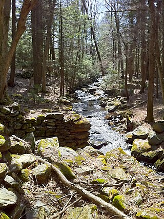
Devil's Hopyard State Park is a public recreation area located at the Eightmile River's Chapman Falls in the town of East Haddam, Connecticut. The 1,000-acre (400 ha) state park includes facilities for hiking, fishing, bicycling, picnicking, and camping. It is managed by the Connecticut Department of Energy and Environmental Protection.
Natchaug State Forest is a Connecticut state forest located in six towns including Ashford, Chaplin, and Eastford. The Natchaug River runs from north to south along the western border of the main forest parcel. James L. Goodwin State Forest abuts Natchaug State Forest to the south. One of the forest units abuts Mashamoquet Brook State Park in Pomfret.

Mount Tom State Park is a public recreation area lying south of US Route 202 in the towns of Washington, Litchfield, and Morris, Connecticut. The state park occupies 231 acres (93 ha) on the southwest shore of Mount Tom Pond and is home to the Mount Tom Tower, which was listed on the National Register of Historic Places in 1993. It is managed by the Connecticut Department of Energy and Environmental Protection.
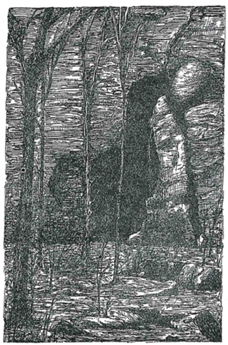
Mashamoquet Brook State Park is a public recreation area in the town of Pomfret, Connecticut. Notable features of the state park include the Wolf Den national historic site, the Brayton Grist Mill, and the Table Rock and Indian Chair natural stone formations. The state park offers facilities for camping, swimming, fishing, and picnicking. It is managed by the Connecticut Department of Energy and Environmental Protection.

Topsmead State Forest is a Connecticut state forest located in the town of Litchfield. It was formerly the summer residence of Edith Morton Chase, daughter of Henry Sabin Chase, first president of the Chase Brass and Copper Company. She left the house and its grounds to the state of Connecticut on her death in 1972. The estate house, built in 1929 to a design by Richard Henry Dana, is a fine example of a Tudor Revival country estate house, and is listed on the National Register of Historic Places.
Bolton Notch State Park is a public Protected recreation area located in the town of Bolton, Connecticut, on the boundary between the Thames River and Connecticut River watersheds. The state park's 95 acres (38 ha) offer opportunities for hiking, climbing, and cave exploration. Bolton Notch is located at the junction of U.S. Route 44 and U.S. Route 6 in Bolton, CT.
Windsor Meadows State Park is a public recreation area on the west side of the Connecticut River in the town of Windsor, Connecticut. The state park occupies three largely undeveloped sections measuring 48, 19, and 88 acres located between railroad tracks and the river. Park activities include picnicking, fishing, boating, hiking, and biking.

Quaddick State Park is a public recreation area located on 203-acre (82 ha) Middle Quaddick Reservoir in the town of Thompson, Connecticut. The state park is managed by the Connecticut Department of Energy and Environmental Protection and offers opportunities for boating, swimming, fishing, and picnicking.

Dennis Hill State Park is a public recreation area located in the town of Norfolk, Connecticut, that was once the estate of Dr. Frederick Shepard Dennis. The state park offers hiking, picnicking, and scenic views. It is administered by the Connecticut Department of Energy and Environmental Protection.

Humaston Brook State Park is an under-developed day use state park located in the village of Northfield, Connecticut. It preserves a stretch of Humaston Brook, a tributary of the Naugatuck River. Its major feature is Northfield Pond, created by damming in the 19th century. It is commonly known by residents as Knife Shop Pond. It also includes the foundations of the former Northfield Knife Company located along the banks of the brook below the dam, which was the location of one of Litchfield's largest 19th-century employers. Activities in the park include hiking and fishing.

Macedonia Brook State Park is a public recreation area covering 2,302 acres (932 ha) in the town of Kent, Connecticut, United States. Visitors can camp in a 51-site campground, picnic, fish, and hike the blue-blazed Macedonia Ridge Trail, which crosses Cobble Mountain and other peaks. The park's first 1,552 acres (628 ha) were a gift made in 1918 by the White Memorial Foundation.

Becket Hill State Park Reserve is a public recreation area lying adjacent to Nehantic State Forest in the town of Lyme, Connecticut. The state park is as an undeveloped, walk-in park totaling 260 acres (110 ha) with no officially listed activities. It is managed by the Connecticut Department of Energy and Environmental Protection.
Selden Neck State Park is a 607-acre (246 ha) island and public recreation area on the Connecticut River in the town of Lyme, Connecticut. Accessible only by boat, the state park has four areas for primitive, riverside camping. Hiking, fishing, and hunting are also available. The park was among the first parcels secured for park purposes by the state, with initial land purchases on the island made in 1917. It is managed by Connecticut Department of Energy and Environmental Protection.


