The Lewis and Clark Expedition, also known as the Corps of Discovery Expedition, was the United States expedition to cross the newly acquired western portion of the country after the Louisiana Purchase. The Corps of Discovery was a select group of U.S. Army and civilian volunteers under the command of Captain Meriwether Lewis and his close friend Second Lieutenant William Clark. Clark and 30 members set out from Camp Dubois, Illinois, on May 14, 1804, met Lewis and ten other members of the group in St. Charles, Missouri, then went up the Missouri River. The expedition crossed the Continental Divide of the Americas near the Lemhi Pass, eventually coming to the Columbia River, and the Pacific Ocean in 1805. The return voyage began on March 23, 1806, at Fort Clatsop, Oregon, and ended on September 23 of the same year.

Grafton is the oldest city in Jersey County, Illinois, United States. It is located near the confluence of the Illinois and Mississippi Rivers. As of the 2020 census, the city had a total population of 626. Prior to the Great Flood of 1993, Grafton had enjoyed a stable population of nearly 1,000 residents.

Hartford is a village in Madison County, Illinois, United States, on the Mississippi River near the mouth of the Missouri River. The population was 1,185 at the 2020 census, down from 1,429 in 2010. Lewis and Clark spent the winter of 1803-04 there, near what has been designated the Lewis and Clark State Historic Site.

The Lewis and Clark National Historical Park, located in the vicinity of the mouth of the Columbia River, commemorates the Lewis and Clark Expedition. Administration of the park, which includes both federal and state lands, is a cooperative effort of the National Park Service and the states of Oregon and Washington. The National Historical Park was dedicated on November 12, 2004.

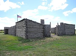
Fort Mandan was the name of the encampment which the Lewis and Clark Expedition built for wintering over in 1804–1805. The encampment was located on the Missouri River approximately twelve miles (19 km) from the site of present-day Washburn, North Dakota, which developed later. The precise location is not known for certain. It is believed now to be under the water of the river. A replica of the fort has been constructed near the original site.

The Lewis and Clark National Historic Trail is a route across the United States commemorating the Lewis and Clark Expedition of 1804 to 1806. It is part of the National Trails System of the United States. It extends for some 4,900 miles (7,900 km) from Pittsburgh, Pennsylvania, to the mouth of the Columbia River in Oregon.

Cape Disappointment State Park is a public recreation area on Cape Disappointment, located southwest of Ilwaco, Washington, on the bottom end of Long Beach Peninsula, the northern headlands where the Columbia River meets the Pacific Ocean. The state park's 2,023 acres (819 ha) encompass a diverse landscape of old-growth forest, freshwater lakes, freshwater and saltwater marshes, and oceanside tidelands. Park sites include Fort Canby, the Lewis and Clark Interpretive Center, North Head Lighthouse, and Cape Disappointment Lighthouse. Cape Disappointment is one of several state parks and sites in Washington and Oregon that are included in Lewis and Clark National Historical Park.

Kaw Point is part of Kaw Point Park, in the Fairfax District of Kansas City, Kansas. Kaw Point Park is administered by the National Park Service as a destination along the Lewis and Clark National Historic Trail. The point is along the shores of the confluence of the Kansas River and the Missouri River, at the eastern termination of the Kansas River, and where the Missouri River turns its southerly course eastward through the state of Missouri to the Mississippi River at St. Louis.
Lewis and Clark Community College is a public community college in Godfrey, Illinois. It serves approximately 3,973 credit and non-credit students annually. The college has nine locations throughout the St. Louis Metro East, including a campus and humanities center in Edwardsville, Illinois; community education centers in Alton, Illinois, Carlinville, Illinois and Jerseyville, Illinois; a training center in Bethalto, Illinois; a river research center in East Alton, Illinois; and a location at the East St. Louis Higher Education Center in East St. Louis, Illinois. Lewis and Clark has career and transfer study options. The college also offers personal enrichment programming for adults and children, as well as corporate and safety training options for professionals.

Chouteau Island, situated approximately eight miles (13 km) due north of the Gateway Arch in St. Louis, Missouri, and approximately one mile (1.6 km) south of the confluence of the Missouri River and Mississippi River, is one of a cluster of three islands: Chouteau Island, Gabaret Island, and Mosenthein Island. The three, with a combined area of approximately 5,500 acres (20 km2), are located in Madison County, Illinois.

Gabaret Island, also known as Cabaret Island, situated approximately eight miles (13 km) due north of the Gateway Arch in St. Louis, Missouri, and approximately one mile (1.6 km) south of the confluence of the Missouri River and Mississippi River, is one of a cluster of three islands: Chouteau Island, Gabaret Island, and Mosenthein Island. Gabaret Island is 1,300 acres in area. Due to land development, the island is continuous with its northern neighbor, Chouteau Island, but is separated by a slough.

The Meeting of the Great Rivers Scenic Route extends for 33.0 miles (53.1 km) in southwestern Illinois, travelling through the floodplain of the Mississippi and Illinois Rivers. The route has been officially designated as a National Scenic Byway by the Federal Highway Administration. The route coincides with a portion of the Great River Road.
The Confluence Trail, part of the Madison County, Illinois Transit (MCT) bikeways network, is a 20.5 miles (33.0 km) bike trail between Granite City and Alton, Illinois's Russell Commons Park. The majority of the trail is paved asphalt on top of the Mississippi River levee system. The trail is part of the St. Louis metro area's Confluence Greenway.

Missouri Headwaters State Park is a public recreation area occupying 535 acres (217 ha) at the site of the official start of the Missouri River. The park offers camping, hiking trails, hunting, and water-related activities. It is located on Trident Road northeast of Three Forks, Montana at an elevation of 4,045 feet (1,233 m). The park includes the Three Forks of the Missouri National Historic Landmark, designated in 1960 because the site is one where the Lewis and Clark Expedition camped in 1805.

Lewis and Clark State Recreation Site is a state park in eastern Multnomah County, Oregon, near Troutdale and Corbett, and is administered by the Oregon Parks and Recreation Department. It is located on the Sandy River, near its confluence with the Columbia River. Broughton's Bluff marks the westernmost extent of the Columbia River Gorge at the site.

The Missouri-Yellowstone Confluence Interpretive Center is a museum near Williston, North Dakota. It is dedicated to telling the story of the confluence of the Yellowstone and the Missouri Rivers in the western section of North Dakota near the Montana border. It features exhibits on the geography, geology, and history of the area. The interpretive center is located one-half mile east of historic Fort Buford near Williston, North Dakota. It also offers dramatic views of the Missouri and Yellowstone Rivers.

Old Baldy, also known as the Tower, is a hill located near the village of Lynch, in Boyd County, in the northern part of the state of Nebraska in the Midwestern United States. It was visited by the Lewis and Clark Expedition on their way up the Missouri River in 1804; nearby, they discovered a colony of prairie dogs, an animal previously unknown to scientists.
The Lincoln Trail State Memorial is a sculpture group designed in 1937 by Nellie Verne Walker and erected in 1938 to commemorate the first entrance of Abraham Lincoln, then a destitute 21-year-old frontiersman, into Illinois. It is located at the west end of the Lincoln Memorial Bridge on U.S. Route 50 Business in rural Lawrence County, approximately 11 miles (18 km) east of Lawrenceville.