List of round barns

Last updated

1917-built Leonard Barn in Washington state T. A. Leonard Barn.jpg
1917-built Leonard Barn in Washington state

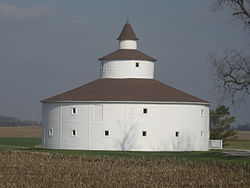
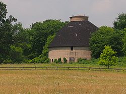
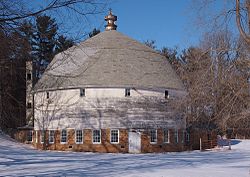
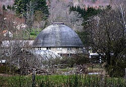
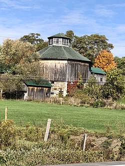
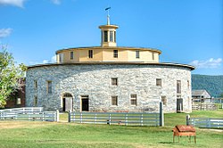
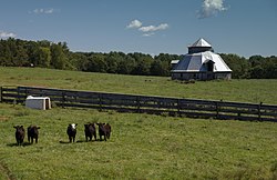
What are termed round barns include historic barns having true circular designs and also octagonal or other polygonal designs that approximate a circle. In the United States, in a first era of round barn construction, from 1850 to 1900, numerous octagonal barns were built. In a second era, from 1889 to 1936, numerous true circular barns were built. [1] [2]

Contents

This list article includes surviving or historic round barns in Canada, the United States, and elsewhere. There were 19 historic round and polygonal barns in Canada identified as surviving in the 1970s, in a list compiled by members of a club and typed up by Katherine Kirkam. [3] According to Matthew Farfan, nine round barns survive in the Eastern Townships of the province of Quebec, all close to the U.S. border. [4] [note 1]

Besides paying attention to Canadian barns, Kirkham also studied American barns; in the 1970s, she identified 444 surviving barns in the United States. [3] Many of them are listed on the National Register of Historic Places. [5]

Dale J. Travis has identified and photographed (or collected photos of) round barns and other round or polygonal buildings throughout the United States and Canada. [6] His webpages document the loss of numerous historic round barns.

The periods during which round barns were built varies across U.S. states. Most of Indiana's round barns were built between 1900 and 1920, and their construction peaked in 1910. Iowa's peak years were from 1909 to 1922. All 44 of the historic round barns built in South Dakota were built between 1903 and 1946. North Dakota's peak years were from 1910 to 1916. South Dakota had none built before 1900 because the state had yet to be developed. [7]

Canada

As documented here, there are at least 11 surviving octagonal, true round, and other round-type barns in Quebec. A few others survive in British Columbia, Alberta and Ontario. A list of round or near-round structures in Quebec, including historic round barns, developed by Dale J. Travis has informed this compilation. [8] [note 2] Similar for other provinces at Travis site. Travis also includes less historic structures.

This includes others not in Travis's compilation, such as the Higginson Round Barn, which is an impressive and old one.

Following is incomplete, but is intended to become a complete list, from West to East:

BuildingImageDatesfosgLocationCity, ProvinceDescription
Fintry Estate barn1925 [9] Fintry Provincial Park and Protected Area, 7655 Fintry Delta Rd. 50°08′14″N119°30′13″W / 50.1371°N 119.5036°W / 50.1371; -119.5036 (Fintry barn) Fintry, Okanagan Country, British Columbia
Henderson Round Barn HendersonRoundBarn FEP.jpg Built 1898, moved 1972 Fort Edmonton Park
53°30′01″N113°34′51″W / 53.5004°N 113.5809°W / 53.5004; -113.5809 (Henderson Round Barn)
Edmonton, Alberta Preserved in a historical park. [4] [10]
Sowerby Barn1928 [11] 131 Brownlee Rd (at Round Barn Rd) 46°16′57″N83°25′58″W / 46.28248°N 83.43273°W / 46.28248; -83.43273 (Sowerby Barn) Huron Shores, OntarioOne of three 12-sided barns still existing in Canada [11] [12]
Cordukes/Weber Barn1919 [11] 1410 Basswood Lakes Road 46°17′54″N83°23′20″W / 46.29841°N 83.38881°W / 46.29841; -83.38881 (Cordukes/Weber Barn) Algoma, Ontario12-sided barn, site of farmers market, has been dismantled, moved and rebuilt adjacent to Sowerby Hall (formerly the Day and Bright Community and Recreation Centre) at 1410 Basswood Lake Road, near Hendry Street. [11] [12] [13] [14] [15]
Octagon barn south of Osgoode Octagon Barn near Osgoode - exterior 6.jpg 5672 Dalmeny Road 45°07′05″N75°35′06″W / 45.11813°N 75.58509°W / 45.11813; -75.58509 (Octagon barn south of Osgoode) Osgoode, Ontario [16]
Higginson Round Barn1893–942500 Highway 34
45°34′49″N74°37′22″W / 45.580283°N 74.622895°W / 45.580283; -74.622895 (Higginson Round Barn)
Hawkesbury, OntarioSeveral sources, hidden.
Walbridge Barn Grange Alexander-Solomon-Walbridge - Entree rez-de-chausse.JPG 1882Chemin de Mystic
45°09′09″N72°59′18″W / 45.15262°N 72.98823°W / 45.15262; -72.98823 (Walbridge Barn)
Mystic, Quebec Oldest surviving polygonal barn in Canada. [17] Also known as Grange Alexander-Solomon-Walbridge, it has a unique roof, became Quebec historic site in 2004 and became a museum in 2011 [4] [18] [19]
Round barn at West BromeChemin Scott 45°10′22″N72°40′27″W / 45.17290°N 72.67410°W / 45.17290; -72.67410 (Round barn at West Brome) West Brome, Quebec [4] [20]
Grange Ronde de Mansonville Grange ronde de Mansonville (Potton).JPG Rue Joseph Blanchet
45°03′11″N72°23′37″W / 45.0531°N 72.3937°W / 45.0531; -72.3937 (Grange Ronde de Mansonville)
Mansonville, QuebecTrue round barn [4] [8]
Round barn at Saint-Benoit-du-LacChemin Fisher
45°09′30″N72°16′13″W / 45.15834°N 72.27020°W / 45.15834; -72.27020 (Round barn at Saint-Benoit-du-Lac)
Saint-Benoit-du-Lac, Quebec A round barn and a round hay tower [4]
Grange ronde Stanley-Holmes Grange ronde Stanley-Holmes.tif 1907Chemin Holmes
45°07′14″N71°58′28″W / 45.120551°N 71.974350°W / 45.120551; -71.974350 (Stanley-Holmes Round Barn)
Barnston-OuestRbcq: "W. of Barnston. Hwy.141 W. from Barnston to Chemin Caron Rd., S. on Chemin Caron Rd. & SE on Chemin de Way's Mill & the barn would be on the right hand (S.) side of the road. Holmhurst Farm, true round barn, red horizontal siding, 2 pitch conical roof, louvered cupola." [8] This is Stanley-Holmes Round Barn, on Holmhurst Farm.
Round barn south of Barnston1909 [8] Chemin de Baldwin Mills Barnston
45°06′03″N71°53′19″W / 45.1008°N 71.8885°W / 45.1008; -71.8885 (Round barn south of Barnston)
South of Barnston, Coaticook, Quebec True round barn with two-pitch conical roof with a cupola, at Ferme Blayrond [4] [8]
Round barn at Barnston1901 [8] Chemin Riendeau
45°06′24″N71°52′42″W / 45.106620°N 71.878271°W / 45.106620; -71.878271 (Round barn at Barnston)
Barnston, Coaticook, QuebecIn Barnston. True round barn with two-pitch conical roof, with cupola [8]
Grange Rondebuilt 1995400 Rue St. Marc., Gorge de Coaticook Park 45°08′41″N71°47′51″W / 45.14477°N 71.79761°W / 45.14477; -71.79761 (Grange Ronde) Coaticook, Quebec [4]
Round barn west of BeaumontPre-1850 [8] Route du Fleuve (Route 132)
46°49′45″N71°02′25″W / 46.829175°N 71.040144°W / 46.829175; -71.040144 (Round barn west of Beaumont)
Beaumont, Quebec White barn [8]
Adolph Gagnon Museum 1888 [8] 48°17′51″N68°51′57″W / 48.297637°N 68.865842°W / 48.297637; -68.865842 (Adolph Gagnon Museum) Saint-Fabien, QuebecMuseum now in former barn [8]
Octagonal barn west of Cap ChatteRue Notre Dame Ouest (2.5 miles west of Cap-Chat) 49°05′12″N66°43′55″W / 49.08668°N 66.73190°W / 49.08668; -66.73190 (Octagonal barn west of Cap-Chat) Cap-Chat, Quebec Octagonal barn west of Cap Chatte [4]
Round barn near Dunham Dunham, Quebec
Holmes' Barnc. 1907 [21] Ways Mills, Quebec [4] [22]
Second of two round barns near Ways Mills Ways Mills, Quebec [4]

United States

West: California, Oregon, Washington, New Mexico, Colorado

BuildingImageDatesLocationCity, StateDescription
Barn north of American CanyonS. Napa Junction Rd
38°10′43″N122°14′53″W / 38.17868°N 122.24803°W / 38.17868; -122.24803 (Barn north of American Canyon)
American Canyon, Napa Valley, California 20-sided, 100 feet (30 m) barn [23]
San Luis Obispo Octagon Barn Octagon Barn San Luis Obispo wiki.jpg built pre-1900, restored 2009 [24] Octagon Way, off Higuera St.
35°14′13″N120°40′47″W / 35.23687°N 120.67959°W / 35.23687; -120.67959 (Barn south of San Luis Obispo)
San Luis Obispo, California Octagonal barn, 77 feet (23 m) by 80 feet (24 m) [24]
Knight Barnbuilt 1894–962955(?) Copenhagen Road
40°40′40″N124°15′12″W / 40.677882°N 124.25336°W / 40.677882; -124.25336 (Knight Barn)
Loleta, California 16-sided barn, shown standing in photos by Mary Louise Lorensen. [25] Shows collapsed in center in Google 2016 satellite imagery.
Fountaingrove Round Barn Fountaingrove Round Barn.jpg Fountaingrove Parkway at Round Barn Blvd
38°28′33″N122°43′39″W / 38.475767°N 122.72746°W / 38.475767; -122.72746 (Fountaingrove Round Barn)
Fountaingrove, Santa Rosa, California 16-sided, [26] destroyed during the Tubbs Fire of 2017. [27] [28]
De Turk Round Barn De Turk Round Barn, 819 Donahue St., Santa Rosa, CA 6-12-2010 8-05-53 PM.JPG built 1891
NRHP 2004
819 Donahue St.
38°26′28″N122°43′26″W / 38.44111°N 122.72389°W / 38.44111; -122.72389 (De Turk Round Barn)
Santa Rosa, California [29]
R. L. Johnston Round Barn (also called Beaver Creek Ranch Barn [30] ) Fall River Mills Round Barn.JPG 18-sided barn built in 1916; last remains dismantled 2007; rebuilt 2009Fort Crook Ave
41°00′07″N121°26′47″W / 41.001843°N 121.446295°W / 41.001843; -121.446295 (R. L. Johnston Round Barn)
Fall River Mills, California Built "...to break and train wild horses for the U. S. Army." Reconstructed on grounds of Fort Crook Museum. [31] [30] [32]
Mount Weske Stables Mount Weske Stables, Windsor, California.jpg Octagonal structure built in 1870s or 1880s.1520 Mount Weske Drive
38°34′05″N122°47′40″W / 38.567919°N 122.794434°W / 38.567919; -122.794434 (Mount Weske Stables)
Windsor, California [33] Houses racehorses.
Pete French Round Barn Peter French Round Barn (Harney County, Oregon scenic images) (harDA0027).jpg Built c. 1875–1885 43°07′57″N118°38′33″W / 43.13250°N 118.64250°W / 43.13250; -118.64250 (Pete French Round Barn) Burns, Oregon Cattle rancher Peter French (1849–1897) broke and trained horses there in winter.
Lake County Round Sale Barn Lake County Round Sale Barn - Lakeview Oregon.jpg 1942 built
2003 NRHP-listed
3531 S. 6th Street
42°11′43″N120°21′40″W / 42.195342°N 120.361078°W / 42.195342; -120.361078 (Lake County Round Sale Barn)
Lakeview, Oregon
Laughlin Round Barn Laughlin Round Barn.jpg built 1883
NRHP 1986
46°20′25″N122°55′24″W / 46.34028°N 122.92333°W / 46.34028; -122.92333 (Laughlin Round Barn) Castle Rock, Washington
Ojo Caliente Hot Springs Round Barn Ojo Caliente Hot Springs Round Barn.jpg 1924 built
2003 NRHP-listed
36°18′37″N106°2′48″W / 36.31028°N 106.04667°W / 36.31028; -106.04667 (Ojo Caliente Hot Springs Round Barn) Ojo Caliente, New Mexico Only round barn in New Mexico and the only adobe round barn in the U.S. [34]
DeLaney Barn DeLaney Barn.JPG built 1902; NRHP 1989200 S. Chambers Rd.
39°42′48″N104°48′27″W / 39.71333°N 104.80750°W / 39.71333; -104.80750 (DeLaney Barn)
Aurora, Colorado Only surviving round barn in Colorado. Built in 1902 as a silo. Converted into a dairy barn by 1910. [35]
T. A. Leonard Barn T. A. Leonard Barn.jpg built 1917; NRHP 1986S. side of Old Moscow Highway, near Pullman, Washington
46°42′16″N117°07′23″W / 46.704444°N 117.123056°W / 46.704444; -117.123056 (Leonard Barn)
Whitman County, Washington Very tall. Considered endangered before “saved” in 1992. [36]
Cornell Farmstead barn Cornell Farmstead NRHP 87000055 Yakima County, WA.jpg NRHP 1987Pleasant Rd. and Old Prosser Rd., in or near Grandview
46°14′35″N119°53′41″W / 46.243056°N 119.894722°W / 46.243056; -119.894722 (Cornell Farmstead)
Yakima County, Washington

Central

Illinois

See Round Barns in Illinois Thematic Resources for a discussion of current and former round barns in the state.

BuildingImageDatesLocationCity, StateDescription
University of Illinois round barns Dairy farm 4390.jpg 1907–1913 40°5′40″N88°13′22″W / 40.09444°N 88.22278°W / 40.09444; -88.22278 (University of Illinois round barns) Urbana, Illinois Important leading examples.
Wheeler-Magnus Round Barn Wheeler-Magnus Round Barn (Arlington Heights, IL) 01.JPG c. 1910 42°5′42″N87°58′51″W / 42.09500°N 87.98083°W / 42.09500; -87.98083 (Wheeler-Magnus Round Barn) Arlington Heights, Illinois Only round barn surviving in Cook County.
Clarence Kleinkopf Round Barn Clarence Kleinkopf Round Barn NRHP 82002586 McDonough County, IL.jpg built 1915 40°25′31″N90°47′32″W / 40.42528°N 90.79222°W / 40.42528; -90.79222 (Clarence Kleinkopf Round Barn) Colchester, Illinois One of 3 round barns in area built by carpenter Dick Carmack
Robert Weber Round Barn Durand Il Weber Round Barn6.jpg 1917 42°24′43″N89°14′11″W / 42.41194°N 89.23639°W / 42.41194; -89.23639 (Robert Weber Round Barn) Durand, Illinois
Dennis Otte Round Barn Eleroy Il Otte Round Barn2.JPG 1930 42°19′59″N89°44′58″W / 42.33306°N 89.74944°W / 42.33306; -89.74944 (Dennis Otte Round Barn) Eleroy, Illinois
Gerald Harbach Round Barn Eleroy Il Harbach Round Barn4.JPG built c.1914
NRHP 1984
42°19′41″N89°45′12″W / 42.32806°N 89.75333°W / 42.32806; -89.75333 (Gerald Harbach Round Barn) Eleroy, Illinois A 55-foot (16.8-m) diameter barn upon a poured concrete foundation. Its wood sided exterior has been covered in asphalt since the building's construction.
James Bruce Round Barn Freeport Il Bruce Round Barn7.JPG built 1914
NRHP 1984
42°15′6″N89°38′55″W / 42.25167°N 89.64861°W / 42.25167; -89.64861 (James Bruce Round Barn) Freeport, Illinois Constructed by Jeremiah Shaffer and the Haas Brothers, who built at least 12 round barns in the area. Features a single hip roof design probably influenced by the Agricultural Experiment Stations at the University of Illinois and the University of Wisconsin–Madison.
Ryan Round Barn Kewanee, Illinois - Ryan Round Barn at Johnson Sauk Trail State Recreation Area.JPG built 1910
NRHP 1974
41°14′28″N89°55′32″W / 41.24111°N 89.92556°W / 41.24111; -89.92556 (Ryan Round Barn) Kewanee, Illinois
Chris Jensen Round Barn 42°23′30″N89°50′6″W / 42.39167°N 89.83500°W / 42.39167; -89.83500 (Chris Jensen Round Barn) Lena, Illinois
Lewis Round Barn Lewis Round Barn - Adams County Fairgronds Mendon, IL.jpg 1914 40°5′18″N91°17′4″W / 40.08833°N 91.28444°W / 40.08833; -91.28444 (Lewis Round Barn) Mendon, Illinois
Robert Buckles Barn Robert Buckles Barn from the road.jpg Built 1917
Added to the NRHP in 1983
39°59′8″N89°16′25″W / 39.98556°N 89.27361°W / 39.98556; -89.27361 (Robert Buckles Barn) Mount Pulaski, Illinois Vitrified tile exterior
Charles Fehr Round Barn Orangeville Il Fehr Round Barn2.jpg built 1912
NRHP 1984
42°29′34″N89°31′20″W / 42.49278°N 89.52222°W / 42.49278; -89.52222 (Charles Fehr Round Barn) Orangeville, Illinois Interesting for its hipped roof
Raymond Schultz Round Barn Raymond Schulz Round Barn 2013-09-19 07-03-14.jpg 40°51′43″N88°39′9″W / 40.86194°N 88.65250°W / 40.86194; -88.65250 (Raymond Schultz Round Barn) Pontiac, Illinois
Ron George Round Barn RGeorgeBarn.JPG NRHP 1982 41°38′26″N88°6′10″W / 41.64056°N 88.10278°W / 41.64056; -88.10278 (Ron George Round Barn) Romeoville, Illinois $1,500 building that with a diameter of 60 foot (18 m). Served nine horse stalls and may have served cows as well. Its wooden cupola is raised sixty feet above a concrete foundation.
Virginia Tillery Round Barn Virginia Tillery Round Barn.jpg 1912 39°26′26″N90°26′37″W / 39.44056°N 90.44361°W / 39.44056; -90.44361 (Virginia Tillery Round Barn) Whitehall, Illinois

Indiana

BuildingImageDatesLocationCity, StateDescription
The Barns at Nappanee Round Barn 18-02-15 009.jpg 41°26′37″N86°01′11″W / 41.443606°N 86.019718°W / 41.443606; -86.019718 (Round Barn) Nappanee Operating as ‘’’Round Barn Theatre’’’.
Ben Colter Polygonal Barn Ben Colter Polygonal Barn.jpg 40°47′53″N84°50′27″W / 40.798071°N 84.840765°W / 40.798071; -84.840765 (Round Barn) Adams County
Cornish Griffin Round Barn Cornish Griffin Round Barn.jpg 41°36′45″N85°02′07″W / 41.612558°N 85.035280°W / 41.612558; -85.035280 (Round Barn) Pleasant Lake, Indiana
Crown Point Round Barn Crown Pt Rd Barn 2018-10-01 001.jpg 41°22′11″N87°19′06″W / 41.369828°N 87.318462°W / 41.369828; -87.318462 (Round Barn) Crown Point, Indiana 1410 E 137th Ave, Crown Point
Duvall Round Barn Buffalo RB 18-12-26 014.jpg built: 1914. New Roof: 1972 40°53′44″N86°44′38″W / 40.895659°N 86.74383°W / 40.895659; -86.74383 (Duvall Round Barn) Buffalo, Indiana
John Haimbaugh Round Barn John Haimbaugh Round Barn, snow falling.jpg Built 1914, 41°06′46″N86°11′11″W / 41.112874°N 86.186373°W / 41.112874; -86.186373 (George Fox Round Barn) Rochester, Indiana
George Hall Round Barn HABS IND,35-MED.V,1A- (sheet 4 of 6) - George Hall Barn, Rural Route 1, Medora, Jackson County, IN 00004v.jpg built 1912 38°51′15″N86°08′13″W / 38.854250°N 86.137067°W / 38.854250; -86.137067 (George Hall Round Barn) Medora, Indiana
Hileman Round Barn Hileman RD 20-02-29 100.jpg 40°59′22″N85°55′40″W / 40.989315°N 85.927712°W / 40.989315; -85.927712 (Hileman Round Barn) Silver Lake, Indiana
Martin Hofherr Round Barn HABS IND,18-YORK.V,1A- (sheet 4 of 5) - Hofherr Round Barn, County Road 650 West, Yorktown, Delaware County, IN 00004v.jpg Built: 1904 (demolished) 40°11′41″N85°30′26″W / 40.194702°N 85.507258°W / 40.194702; -85.507258 (Round Barn) York, Indiana
Jasper Hufty Farm Round Barn Hufty Farm 18-12-26 025.jpg 40°35′18″N86°45′25″W / 40.588373°N 86.756993°W / 40.588373; -86.756993 (Hufty-Gruber Round Barn) Delphi, Indiana
Tom Jones Round Barn West Facade 20-10-22 078.jpg Built: 1907 40°57′25″N86°28′03″W / 40.957083°N 86.467630°W / 40.957083; -86.467630 (Round Barn) Kewanna, Indiana
Bert Leedy Round Barn Bert Leedy Round Barn Fulton County Museum P9270568.jpg 41°06′32″N86°14′27″W / 41.108822°N 86.240846°W / 41.108822; -86.240846 (Bert Leedy Round Barn) Rochester, Indiana
Frank Littleton Round Barn Frank Littleton Round Barn.jpg built 1903
NRHP 1993
39°52′22″N85°53′24″W / 39.872850°N 85.890100°W / 39.872850; -85.890100 (Frank Littleton Round Barn) Mount Comfort, Indiana
Thomas Ranck Round Barn Round barn Indiana.jpg b. c.1885–1910
NRHP 1983
39°42′50″N85°2′40″W / 39.71389°N 85.04444°W / 39.71389; -85.04444 (Thomas Ranck Round Barn) Brownsville, Indiana 70 feet diameter, 70 feet tall barn featuring two rows of clerestories; stands out as one of the most elaborately designed structures in eastern Indiana.
Marion Ridgeway Polygonal Barn Marion Ridgeway Polygonal Barn.jpg built 1878, restored 2001 41°35′24″N86°42′09″W / 41.590000°N 86.702500°W / 41.590000; -86.702500 (Marion Ridgeway Polygonal Barn) LaPorte, Indiana
Everett Rouch Round Barn RdBarns 2019-02-26 020.jpg 41°29′12″N86°13′59″W / 41.486610°N 86.232990°W / 41.486610; -86.232990 (Everett Rouch Round Barn) Bremen, Indiana
Round barn in Muncie 40°07′55″N85°19′40″W / 40.13197°N 85.32786°W / 40.13197; -85.32786 (Round barn in Muncie) Muncie, Indiana Identified as "The Round Barn" in Google maps. Verified as round barn by street view.
Rebecca Rankin Round Barn Rebecca Rankin Round Barn.jpg Poling, Indiana
Quivey Round Barn Quivey Rd Barn Pan.jpg Built 1913–14 41°15′04″N86°20′17″W / 41.251128°N 86.338028°W / 41.251128; -86.338028 (Quivey Round Barn) Argos, Indiana This is a 12 sided barn, red vertical siding, cupola, 3-pitch sectional roof.
Frank Senour Round Barn FrankSenourRoundBarn.jpg Blackhawk, Indiana
Strauther Pleak Round Barn Strauther Pleak Round Barn.jpg Greensburg, Indiana
Don Smiley Round Barn Smiley Barn 28-12-14 050.jpg Built 1914 41°03′48″N86°14′11″W / 41.063389°N 86.236505°W / 41.063389; -86.236505 (Don Smiley Round Barn) Rochester, Indiana
Utter-Gerig Round Barn Utter-Gerig Round Barn.jpg Akron, Indiana
Andrew B. VanHuys Round Barn Andrew B. VanHuys Round Barn.jpg Lebanon, Indiana
Menno Yoder Round Barn Round Barn 2019-04-23 002.jpg Built in 1908 41°40′33″N85°35′41″W / 41.675860°N 85.594742°W / 41.675860; -85.594742 (Brown Swiss Dairy Round Barn) Lodi, Indiana
W. H. York Round Barn W.H. York Round Barn.jpg Lodi, Indiana
Weller-Calloway Round Barn Calloway 28-12-14 067.jpg Built 1914, 40°57′02″N86°09′56″W / 40.950433°N 86.165483°W / 40.950433; -86.165483 (Weller-Calloway Round Barn) Rochester, Indiana
Watson Round Barn, or
Oliver Perry Watson Round Barn
Oliver Perry Watson Round Barn.jpg 1907–08 40°44′31″N85°35′41″W / 40.741927°N 85.594800°W / 40.741927; -85.594800 (Watson Round Barn) Mt. Etna, IN
Wideman-Gerig Round Barn– Round Barn Golf Club Entrance 18-12-14 030.jpg 41°03′51″N86°12′06″W / 41.064214°N 86.201705°W / 41.064214; -86.201705 (Round Barn Golf Club) Rochester
E. O. White/ Hazelwood Round Barn
Hazelwood Round Barn.jpg
1916Dana, Vermillion County, IndianaThe center silo is seventy-two feet tall and the barn is sixty foot in diameter.

Iowa

BuildingImageDatesLocationCity, StateDescription
Nelson Round Barn Nelson Round Barn, Allerton, IA.jpg built 1912
NRHP 1986
County Road J46
40°42′24″N93°20′44″W / 40.70667°N 93.34556°W / 40.70667; -93.34556 (Nelson Round Barn)
Allerton, Iowa
George Darrow Round Barn built 1916
NRHP 1986
County Road T76
43°9′52″N92°29′46″W / 43.16444°N 92.49611°W / 43.16444; -92.49611 (George Darrow Round Barn)
Alta Vista, Iowa
Thomsen Round Barn built 1912
NRHP 1986
Off Iowa Highway 15
43°20′46″N94°29′52″W / 43.34611°N 94.49778°W / 43.34611; -94.49778 (Thomsen Round Barn)
Armstrong, Iowa
Lenox Round Barn Lenox Round Barn.jpg built 1905
NRHP 1999
1001 Pollock Blvd.
40°40′39″N94°43′45″W / 40.67750°N 94.72917°W / 40.67750; -94.72917 (Lenox Round Barn)
Bedford, Iowa
William Oakland Round Barn William Oakland Round Barn, 210th Street, Blairsburg, Iowa.JPG built 1910
NRHP 1986
Off U.S. Route 69
42°29′11″N93°38′0″W / 42.48639°N 93.63333°W / 42.48639; -93.63333 (William Oakland Round Barn)
Blairsburg, Iowa
Nebergall "Knoll Crest" Round Barn Scott County, Iowa Round Barn.jpg built 1914
NRHP 1986
Telegraph Road
41°30′59″N90°42′54″W / 41.51639°N 90.71500°W / 41.51639; -90.71500 (Nebergall "Knoll Crest" Round Barn)
Blue Grass, Iowa built by Benton Steele
Round Barn, Buckingham Township BuckinghamTownshipRoundBarn.jpg built 1920
NRHP 1986
Off U.S. Route 63
42°17′1″N92°28′35″W / 42.28361°N 92.47639°W / 42.28361; -92.47639 (Round Barn, Buckingham Township)
Buckingham, Iowa
Wickfield Round Barn built 1919
NRHP 1986
Off Iowa Highway 2
40°40′4″N92°1′23″W / 40.66778°N 92.02306°W / 40.66778; -92.02306 (Wickfield Round Barn)
Cantril, Iowa It has 12 dormers.
C. A. Rownd Round Barn C A Rownd Round Barn Cedar Falls IA pic1.JPG built 1911
NRHP 1986
5102 S. Main St.
42°29′50″N92°27′47″W / 42.49722°N 92.46306°W / 42.49722; -92.46306 (C. A. Rownd Round Barn)
Cedar Falls, Iowa
Brooks Round Barn built 1914
NRHP 1986
West of U.S. Route 218
42°57′0″N92°35′4″W / 42.95000°N 92.58444°W / 42.95000; -92.58444 (Brooks Round Barn)
Charles City, Iowa destroyed in 1995
Spotts Round Barn built 1914
NRHP 1986
Iowa Highway 14
42°56′10″N91°45′1″W / 42.93611°N 91.75028°W / 42.93611; -91.75028 (Spotts Round Barn)
Charles City, Iowa
Robert Kirkpatrick Round Barn Round-barn.jpg built 1919
NRHP 2005
3342–120th Ave.
42°17′55″N91°33′29″W / 42.29861°N 91.55806°W / 42.29861; -91.55806 (Robert Kirkpatrick Round Barn)
Coggon, Iowa
Plagmann Round Barn Plagmann Round Barn, Conroy, Iowa.jpg built 1912
NRHP 1986
County Road V66
41°43′30″N92°3′24″W / 41.72500°N 92.05667°W / 41.72500; -92.05667 (Plagmann Round Barn)
Conroy, Iowa
Waveland Round Barn built 1900
NRHP 1986
Off U.S. Route 20
42°29′46″N95°42′9″W / 42.49611°N 95.70250°W / 42.49611; -95.70250 (Waveland Round Barn)
Cushing, Iowa
Charles B. Reynolds Round Barn built 1924
NRHP 1999
2382 Harrison Ave.
43°18′10″N96°9′21″W / 43.30278°N 96.15583°W / 43.30278; -96.15583 (Charles B. Reynolds Round Barn)
Doon, Iowa
Round Barn, Dubuque Township Dubuque-township-round-barn.jpg built 1915
NRHP 1986
2810 Cascade Rd.
42°28′24″N90°42′27″W / 42.47333°N 90.70750°W / 42.47333; -90.70750 (Round Barn, Dubuque Township)
Dubuque, Iowa
James Greer McQuilkin Round Barn built 1918
NRHP 1986
County Road D56
42°15′51″N91°47′43″W / 42.26417°N 91.79528°W / 42.26417; -91.79528 (James Greer McQuilkin Round Barn)
Eagle Center, Iowa
Round Barn, Bruce Township Section 3 built 1910
NRHP 1986
Off U.S. Route 218
42°17′31″N92°14′8″W / 42.29194°N 92.23556°W / 42.29194; -92.23556 (Round Barn, Bruce Township Section 3)
Eagle Center, Iowa
Seymour Ross Round Barn built 1914
NRHP 1986
Off Iowa Highway 374
Gillett Grove, Iowa
Frantz Round Barn built 1911
NRHP 1986
Off U.S. Route 30
42°2′19″N94°12′4″W / 42.03861°N 94.20111°W / 42.03861; -94.20111 (Frantz Round Barn)
Grand Junction, Iowa
Erza McKenzie Round Barn Roundbarn.jpg built 1922
NRHP 1986
Off Iowa Highway 150
42°36′26″N91°56′7″W / 42.60722°N 91.93528°W / 42.60722; -91.93528 (Erza McKenzie Round Barn)
Hazleton, Iowa
Octagon Round Barn, Indian Creek Township built 1880
NRHP 1986
Off County Road S14
41°57′0″N93°27′6″W / 41.95000°N 93.45167°W / 41.95000; -93.45167 (Octagon Round Barn, Indian Creek Township)
Iowa Center, Iowa
Herman Wood Round Barn Herman Wood Round Barn, rural Iowa Falls, Iowa.JPG built 1916
NRHP 1986
U.S. Route 65
42°33′28″N93°15′2″W / 42.55778°N 93.25056°W / 42.55778; -93.25056 (Herman Wood Round Barn)
Iowa Falls, Iowa
Slayton Farms-Round Barn Slayton Farms Round Barn.jpg built 1915
NRHP 1999
20478 135th St.
42°30′52″N93°17′26″W / 42.51444°N 93.29056°W / 42.51444; -93.29056 (Slayton Farms-Round Barn)
Iowa Falls, Iowa
Round Barn, Washington Township RoundBarnJanesvilleIowa.jpg built 1917
NRHP 1986
Off U.S. Route 218
42°35′7″N92°27′40″W / 42.58528°N 92.46111°W / 42.58528; -92.46111 (Round Barn, Washington Township (Janesville, Iowa))
Janesville, Iowa
Round Barn, Bruce Township Section 6 built 1914
NRHP 1986
West of U.S. Route 218
42°17′13″N92°16′50″W / 42.28694°N 92.28056°W / 42.28694; -92.28056 (Round Barn, Bruce Township Section 6)
La Porte, Iowa
Tonsfeldt Round Barn LeMarsIA TonsfeldRoundBarn.jpg built 1918
NRHP 1986
Plymouth County Fairgrounds
42°47′52″N96°9′34″W / 42.79778°N 96.15944°W / 42.79778; -96.15944 (Tonsfeldt Round Barn)
Le Mars, Iowa
Fred W. Meier Round Barn built 1912
NRHP 1986
Off Iowa Highway 9
43°14′3″N91°28′34″W / 43.23417°N 91.47611°W / 43.23417; -91.47611 (Fred W. Meier Round Barn)
Ludlow, Iowa Former true round barn measuring 56 feet (17 m) around. [37] Featured stone and featured red horizontal siding, 2-pitch conical roof, aerator and an internal wood stave silo. [37] Destroyed in a thunderstorm during night of July 27, 2002. [38]
Round Barn, Cooper Township built 1921
NRHP 1986
Iowa Highway 141
42°7′59″N95°44′14″W / 42.13306°N 95.73722°W / 42.13306; -95.73722 (Round Barn, Cooper Township)
Mapleton, Iowa
Round Barn, Millville Township ROUND BARN, MILLVILLE TOWNSHIP.jpg built 1916
NRHP 1986
U.S. Route 52
42°42′56″N91°5′4″W / 42.71556°N 91.08444°W / 42.71556; -91.08444 (Round Barn, Millville Township)
Millville, Iowa
Holtkamp Round Barn The Holtkamp Round Barn.jpg built 1918
NRHP 1986
Off U.S. Route 218
40°49′16″N91°33′23″W / 40.82111°N 91.55639°W / 40.82111; -91.55639 (Holtkamp Round Barn)
Salem, Iowa
Round Barn, Norway Township built 1920
NRHP 1987
Off County Road R60
43°29′22″N93°35′18″W / 43.48944°N 93.58833°W / 43.48944; -93.58833 (Round Barn, Norway Township)
Scarville, Iowa
Round Barn, Washington Township built 1917
NRHP 1986
U.S. Route 71
41°3′39″N94°59′1″W / 41.06083°N 94.98361°W / 41.06083; -94.98361 (Round Barn, Washington Township (Sciola, Iowa))
Sciola, Iowa
Miller Round Barn Joseph Miller Barn - first round barn east of the Mississippi.jpg built 1918
NRHP 1986
County Road F62
41°33′38″N91°37′52″W / 41.56056°N 91.63111°W / 41.56056; -91.63111 (Miller Round Barn)
Sharon Center, Iowa
Eckle Round Barn built 1928
NRHP 1986
Off Iowa Highway 168
41°3′39″N94°59′1″W / 41.06083°N 94.98361°W / 41.06083; -94.98361 (Eckle Round Barn)
Shelby, Iowa
Dobbin Round Barn Dobbin Round Barn Marshall County, Iowa.jpg built 1919
NRHP 1986
Off County Road S52
41°59′6″N93°11′58″W / 41.98500°N 93.19944°W / 41.98500; -93.19944 (Dobbin Round Barn)
State Center, Iowa
Round Barn, Pilot Grove Township built 1912
NRHP 1986
County Road H20
41°6′21″N95°4′50″W / 41.10583°N 95.08056°W / 41.10583; -95.08056 (Round Barn, Pilot Grove Township)
Stennett, Iowa
John W. Young Round Barn built 1917
NRHP 1986
Off U.S. Route 63
42°11′36″N92°28′28″W / 42.19333°N 92.47444°W / 42.19333; -92.47444 (John W. Young Round Barn)
Traer, Iowa
Clark Round Barn built 1908
NRHP 1986
County Road T7H
40°58′46″N92°52′50″W / 40.97944°N 92.88056°W / 40.97944; -92.88056 (Clark Round Barn)
Tyrone, Iowa

Kentucky

BuildingImageDatesLocationCity, StateDescription
Bird Octagonal Mule Barn built c.1880
NRHP 1988
Cropper Rd. (Kentucky Route 43), Shelby County, Kentucky, about 3 miles (4.8 km) south of Cropper, Kentucky 38°17′16″N85°07′38″W / 38.28778°N 85.12722°W / 38.28778; -85.12722 (Bird Octagonal Mule Barn) Shelby County, Kentucky Only recorded octagonal barn and one of few mule barns to be identified in Shelby County." [39]

North Dakota

BuildingImageDatesLocationCity, StateDescription
Robert Abell Round Barn built 1942
NRHP 1986
46°22′35″N99°28′29″W / 46.37639°N 99.47472°W / 46.37639; -99.47472 (Robert Abell Round Barn) Burnstad, North Dakota It cost $800 to build.
Urbain Cote Round Barn Urbain Cote Round Barn NRHP 86002755 Rolette County, ND.jpg built 1943
1986
47°38′40″N100°3′30″W / 47.64444°N 100.05833°W / 47.64444; -100.05833 (Urbain Cote Round Barn) Dunseith, North Dakota Its hay loft floor "was used by roller skaters during the 1950s and shows little wear or sagging." [40] :2
Rodman Octagonal Barn built 1890
NRHP 1986
46°24′33″N98°47′17″W / 46.40917°N 98.78806°W / 46.40917; -98.78806 (Rodman Octagonal Barn) Near Edgeley, North Dakota
Gerhardt Octagonal Pig House built 1930
NRHP 1986
46°52′28″N102°29′37″W / 46.87444°N 102.49361°W / 46.87444; -102.49361 (Gerhardt Octagonal Pig House) Near Gladstone, North Dakota An octagonal pig-house deemed to meet the NRHP multiple property criteria for North Dakota round barns
Carlott Funseth Round Barn built 1909
NRHP 1986
47°46′46″N97°35′56″W / 47.77944°N 97.59889°W / 47.77944; -97.59889 (Carlott Funseth Round Barn) Kempton, North Dakota Built by Sven and Ole Olson to replace a previous, octagonal barn
Cecil Baker Round Barn built 1921
NRHP 1986
47°15′13″N98°52′47″W / 47.25361°N 98.87972°W / 47.25361; -98.87972 (Cecil Baker Round Barn) Kensal, North Dakota Apparently a kit barn, purchased from the Gordon Vantine Company of Davenport, Iowa. [41] :25
Sylvanus Marriage Octagonal Barn built 1902
NRHP 1986
47°36′50″N99°5′50″W / 47.61389°N 99.09722°W / 47.61389; -99.09722 (Sylvanus Marriage Octagonal Barn) Near New Rockford, North Dakota Octagonal barn
Jens Myhre Round Barn built 1919
NRHP 1986
47°44′46″N99°12′11″W / 47.74611°N 99.20306°W / 47.74611; -99.20306 (Jens Myhre Round Barn) New Rockford, North Dakota Only surviving North Dakota round barn with a ramp to its mow area, hence "may have been perceived as out of fashion and behind the times." [42] :41
Niels Nielsen Fourteen-Side Barn Farm NEILS NIELSEN FOURTEEN-SIDE BARN FARM.jpg built 1914
NRHP 1986
48°49′54″N102°57′33″W / 48.83167°N 102.95917°W / 48.83167; -102.95917 (Niels Nielsen Fourteen-Side Barn Farm) Near Noonan, North Dakota Pre-cut kit barn from a firm in Chicago [43]
Levi Glick Round Barn built 1923
NRHP 1986
48°13′29″N101°10′20″W / 48.22472°N 101.17222°W / 48.22472; -101.17222 (Levi Glick Round Barn) Surrey, North Dakota

Ohio

BuildingImageDatesLocationCity, StateDescription
Round Barn (Columbus Grove, Ohio) Built 1910
NRHP 1980
Columbus Grove, Ohio
Round Barn (Lima, Ohio) Isaac Rozell Round Barn from S.jpg Built 1911
NRHP 1980
Lima, Ohio
Round Barn (New Hampshire, Ohio) J.H. Manchester Round Barn, southern angle.jpg Built 1877
NRHP 1980
New Hampshire, Ohio Largest round barn east of the Mississippi River. Also known as J.H. Manchester Round Barn
Round Barn (Paulding, Ohio) William Sinn Round Barn from the southeast.jpg Built 1911
NRHP 1980
Paulding, Ohio
Round Barn (Van Wert, Ohio) Clayton Hoover Round Barn.jpg Built 1910
NRHP 1980
Van Wert, Ohio Also known as Clayton Hoover Round Barn

South Dakota

BuildingImageDatesLocationCity, StateDescription
Pettigrew Barns built 1901
NRHP 2004
44°02′41″N96°35′26″W / 44.04472°N 96.59056°W / 44.04472; -96.59056 (Pettigrew Barns) Flandreau, South Dakota Octagonal barn built before 1903 date which has been cited as earliest round or polygonal barns in South Dakota
Freier Round Barn JonesCountySD FreierRoundBarn.jpg Draper, South Dakota
Shafer Round Barn Shafer Round Barn Sioux Falls 1.jpg built 1920
NRHP 1995
43°32′31″N96°38′58″W / 43.54194°N 96.64944°W / 43.54194; -96.64944 (Shafer Round Barn) Sioux Falls, South Dakota
Stark Round Barn built 1921
NRHP 2001
43°48′14″N97°27′4″W / 43.80389°N 97.45111°W / 43.80389; -97.45111 (Stark Round Barn) Near Unityville, South Dakota
Corson Emminger Round Barn CORSON EMMINGER ROUND BARN, CODINGTON COUNTY, SD.JPG built 1909–10
NRHP 1978
44°51′41″N97°06′34″W / 44.86128°N 97.10946°W / 44.86128; -97.10946 (Corson Emminger Round Barn) Watertown, South Dakota
J. Whitney Goff Round Barn JWhitneyGoffRoundBarn.jpg Winfred, South Dakota

Wisconsin

BuildingImageDatesLocationCity, StateDescription
Dougan Round Barn Dougan Round Barn.jpg built 1911<annbr>NRHP 1979 42°30′29″N88°59′20″W / 42.50806°N 88.98889°W / 42.50806; -88.98889 (Dougan Round Barn) Beloit, Wisconsin Served a dairy farm of 120 cows. [44] The barn was demolished in 2012. [45]
George Apfel Round Barn GeorgeApfelRoundBarn.jpg built 1914
NRHP 1979
43°39′15″N90°41′24″W / 43.65417°N 90.69000°W / 43.65417; -90.69000 (George Apfel Round Barn) Clinton, Wisconsin Octagonal in shape.
Annala Round Barn Annala Round Barn Buildings Hurley Iron County Wisconsin.jpg built 1921
NRHP 1979
46°25′5″N90°9′41″W / 46.41806°N 90.16139°W / 46.41806; -90.16139 (Annala Round Barn) Hurley, Wisconsin
Central Wisconsin State Fair Round Barn Central Wisconsin State Fair.jpg built 1916 [46]
NRHP 1979
Jct. of Vine Ave. and E. 17th St.

44°39′8″N90°10′27″W / 44.65222°N 90.17417°W / 44.65222; -90.17417 (Central Wisconsin State Fair Round Barn)

Marshfield, Wisconsin The world's largest round barn
Dean-Armstrong-Englund Octagonal Barn built 1893
NRHP-delisted 1984
Near Milton, Wisconsin It had a windmill. [44] :3
Gempeler Round Barn built 1912
NRHP 1979
42°39′50″N89°19′50″W / 42.66389°N 89.33056°W / 42.66389; -89.33056 (Gempeler Round Barn) Near Orfordville, Wisconsin 68 foot diameter barn, "significant for its ingenious construction, with its main story supported by an inverse pylon made up of an oak trunk upside down in the center of the basement" [44] :10
Risum Round Barn Risum Round Barn (Brodhead, Wi).jpg built 1892
NRHP 1979
42°35′55″N89°17′35″W / 42.59861°N 89.29306°W / 42.59861; -89.29306 (Risum Round Barn) Orfordville, Wisconsin Built early, in 1890–92, for a Norwegian immigrant; a 60-foot diameter barn. [44] :6–7
Barn near Mauston TenSidedBarn.jpg Lindina, Wisconsin

Kansas, Minnesota, Montana, Nebraska, Oklahoma

Numerous round and octagon barns in Kansas, including some already- or since-destroyed ones, are covered in a 1999 Kansas State Historical Society study. [47] Round barns in Kansas and these other states include:

BuildingImageDatesLocationCity, StateDescription
Raymond Brinkman barn Raymond Brinkman barn Stillwell Kansas.jpg Built 1912 38°46′04″N94°38′48″W / 38.76778°N 94.64667°W / 38.76778; -94.64667 (Raymond Brinkman barn) Stillwell, Kansas Built to house percherons. 48-foot diameter, 33 feet tall.
Thompson-Wohlschlegel Round Barn Built 1912
NRHP 1985
37°16′33″N97°58′4″W / 37.27583°N 97.96778°W / 37.27583; -97.96778 (Thompson-Wohlschlegel Round Barn) Harper, Kansas
Fromme-Birney Round Barn Mullinville Round Barn and Storm.jpg Mullinville, Kansas
Dammon Round Barn Dammon Round Barn 2.jpg built 1914
NRHP 1980
Red Wing, Minnesota 60 Ft high and 55 ft. in diameter. Has open center in upper floor where silo was originally.
Cota Round Barns Cota Round Barns.jpg built 1921
NRHP 1982
45°34′46″N93°56′50″W / 45.57944°N 93.94722°W / 45.57944; -93.94722 (Cota Round Barns) St. Cloud, Minnesota
Moody Barn Moody Barn 3.JPG built 1915
NRHP 1980
45°18′7″N92°52′14″W / 45.30194°N 92.87056°W / 45.30194; -92.87056 (Moody Barn) Chisago County, Minnesota
Sparre Barn Sparre Barn.jpg Built 1917–24
NRHP 1980
45°20′4.8″N93°28′9.4″W / 45.334667°N 93.469278°W / 45.334667; -93.469278 (Sparre Barn) Anoka County, Minnesota
Doncaster Round Barn Doncaster Round Barn 2015 02.jpg Built 1882
NRHP 2015
45°34′12″N112°18′49″W / 45.57000°N 112.31361°W / 45.57000; -112.31361 (Doncaster Round Barn) Twin Bridges, Montana Birthplace of 1889 Kentucky Derby winner Spokane, NRHP-listed
Kent Dairy Round Barn Kent Dairy Round Barn, Red Lodge, MT.jpg Built 1941
NRHP 1995
45°13′09″N109°14′29″W / 45.21917°N 109.24139°W / 45.21917; -109.24139 (Kent Dairy Round Barn) Red Lodge, Montana
Couser Barn Couser Barn from E 1.JPG built 1912–13
NRHP 1986
Near Laurel, Nebraska Dodecagon-shaped, balloon-framed.
Starke Round Barn Starke Round Barn 5.jpg Built 1902
NRHP 1972
40°5′8.6″N98°26′12.2″W / 40.085722°N 98.436722°W / 40.085722; -98.436722 (Starke Round Barn) Red Cloud, Nebraska
Ehlers Round Barn Ehlers round barn from W 2.JPG built 1922-4
NRHP 1995
40°41′32″N96°34′20″W / 40.69222°N 96.57222°W / 40.69222; -96.57222 (Ehlers Round Barn) Roca, Nebraska Innovative and efficient design; severely damaged by a snowstorm on 4 February 2012, purportedly "beyond repair." [48] [49]
Arcadia Round Barn Arcadia Round Barn (NRHP).jpg Built 1898
NRHP 1977
107 Highway 66
35°39′44″N97°19′33″W / 35.66222°N 97.32583°W / 35.66222; -97.32583 (Arcadia Round Barn)
Arcadia, Oklahoma Famous Route 66 landmark, 60 feet in diameter, built by William "Big Bill" Odor, "subject of a massive, and award-winning, volunteer restoration effort in 1988 when the original roof collapsed" [50]
Hines Round Barn Hines Round Barn, Sallisaw, Oklahoma.jpg Built 1913
NRHP 1984
35°26′55″N94°47′17″W / 35.44861°N 94.78806°W / 35.44861; -94.78806 (Hines Round Barn) Sallisaw, Oklahoma
Frank Uehling Barn Uehling round barn 1.JPG 1918 built
1985 NRHP-listed
41°44′16″N96°30′04″W / 41.73778°N 96.50111°W / 41.73778; -96.50111 (Frank Uehling Barn) Uehling, Nebraska

Mid-Atlantic

Delaware and Pennsylvania

BuildingImageDatesLocationCity, StateDescription
Cherbourg Round Barn CHERBOURG ROUND BARN.jpg built 1918
NRHP 1978

39°9′4″N75°27′27″W / 39.15111°N 75.45750°W / 39.15111; -75.45750 (Cherbourg Round Barn)
Little Creek, Delaware
Neff Round Barn Neff Round Barn.jpg built c.1910
NRHP 1979
Off of Pennsylvania Route 45, Potter Township
40°49′3″N77°42′6″W / 40.81750°N 77.70167°W / 40.81750; -77.70167 (Neff Round Barn)
south of Centre Hall, Pennsylvania
Noah Sheely Round Barn Round barn, Sheely farm. Near Arentsville, Adams County, PA, 1938 by Sheldon Dick.jpg built 1914About 8 miles (13 km) west of Gettysburg, Pennsylvania.In use as a fruit market and for events. [51]

New York

BuildingImageDatesLocationCity, State'Description
McArthur-Martin Hexadecagon Barn McArthur Barn, Bloomville, NY.JPG 1883 built, NRHP-listed 1984 Bloomville in Delaware County, New York16-sided, 100 feet in diameter
Bates Round Barn Brook Haven 1931 Genegantslet Creek Greene NY.jpg 1928–31 [52] NY 12
42°18′10″N75°48′05″W / 42.302852°N 75.801491°W / 42.302852; -75.801491 (Bates Round Barn)
Greene, Chenango County, New York [53]
Young Round Barn Round Barn Farm Dec Taken in 1978.jpg 1914–16 [52] NY 12, about 3 miles south of Greene
42°17′40″N75°48′27″W / 42.29431°N 75.80739°W / 42.29431; -75.80739 (Young Round Barn)
Greene, Chenango County, New York [54]
Kelly Round Barn New York - Kelly Round Barn - 20171001134057.jpg 1893 [52] Halcottsville, Delaware County, New YorkTravis-omitted?
Zoller-Frasier Round Barn c.1895 [52] Newville, Herkimer County, New YorkTravis-omitted?
Bronck Farm 13-Sided Barn Bronck Farm 13-Sided Barn - 01.JPG Peter Bronck Rd. (County Highway 42)
42°20′47″N73°50′41″W / 42.346253°N 73.844812°W / 42.346253; -73.844812 (Bronck Farm Barn)
Coxsackie, Greene County, New York13-sided barn at Bronck Museum [55]
Lunn-Musser Octagon Barn [52] 1885 NY 51
42°35′15″N75°11′48″W / 42.587491°N 75.196781°W / 42.587491; -75.196781 (Musser barn)
New Lisbon, Otsego County, New York [56]
Parker 13-Sided Barn Jefferson 13 Sided Landmark.jpg 1896 NY 10
42°28′53″N74°36′17″W / 42.481327°N 74.604654°W / 42.481327; -74.604654 (Donald Martin Barn)
Jefferson, Schoharie County, New York(Travis identifies this as 12-sided and would name it "Donald Martin barn"?) [57]
Unnamed barn on Daniels Road3339 Daniels Rd.
43°15′13″N78°50′49″W / 43.253691°N 78.847026°W / 43.253691; -78.847026 (Barn on Daniels Road)
Wilson, Niagara County, New York [58]
Baker Octagon Barn [52] Baker Octagon Barn, Richfield Springs, Otsego County, NY.jpg 1882 NY 28 at Walters Way
42°49′26″N75°00′54″W / 42.82385°N 75.014876°W / 42.82385; -75.014876
Ritchfield, Otsego County, New York [59]

NY notes

Gamel hexadecagon barn [52] 16-sided Gamel barn in North Collins, New York

Schultz 15-sided barn (1918–1929) [52] at Cohecton not listed due to DOE owner objection

"Nine octagonal barns, most built in the 1870s and 1880s, have been noted in New York, and undoubtedly many more have never been recorded. Extant examples in the nominated group include the Baker octagon barn near Richfield Springs (1882), the Lunn-Musser octagon barn in New Lisbon (1885), and the Lattin-Crandall octagon barn in Catharine (1893)." [52]

McArthur-Martin barn in Kortright (1883) 16-sided [52]

Parker 13-sided barn (1896) about 15 miles north of Kortright in Jefterson [52]

"Roof types among the nominated examples include conical (for example the Schultz 15-sided barn at Cochecton, New York (1918), gambrel. (the Young round barn at Greene-1914), and domical (Bates barn at Greene)." [52]

11 of 12 listed, p21 [52]

New England

Massachusetts, New Hampshire

BuildingImageDatesLocationCity, Statehidden---->
Round barn at Hancock Shaker Village Round Stone Barn with "House form" in the foreground.jpg 1826, expanded 1870s Hancock, Massachusetts
Round barn on NH-10430 NH-10 44°00′36″N72°04′10″W / 44.01000°N 72.06938°W / 44.01000; -72.06938 (Unidentified round barn on NH-10) Piermont, New Hampshire There is "Round Barn Shoppe" identified on Google maps.

Vermont

BuildingImageDatesLocationCity, StateDescription
Ralph Joslin barn [60] Joslin Round Barn.jpg 1910E. Warren Rd 44°10′05″N72°48′41″W / 44.16805°N 72.81127°W / 44.16805; -72.81127 (Round barn on E. Warren Rd.) Waitsfield, Vermont 12-sided barn built 1910, restored 1990, at Green Mountain Cultural Center [60] Farm had been in one family seven generations. [61] An "Inn at the Round Barn Farm" is there.
Robinson Brothers barn1910,16(?)Robinson Road 43°50′13″N72°26′02″W / 43.837057°N 72.434026°W / 43.837057; -72.434026 (Robinson Brothers barn) Strafford Township, Orange County, Vermont10-sided barn [62]
Russell Moore barn
Shelburne Museum
Shelburne Museum Round Barn 2019.jpg 1899 U.S. 5 44°20′34″N72°02′35″W / 44.342831°N 72.042986°W / 44.342831; -72.042986 (Russell Moore barn) St. Johnsbury, Vermont Russell Moore barn, [63] moved 1985–86 partly by helicopter and serves as orientation center of the Shelburne Museum. [64]
Butson barn1903Round Barn Road 44°07′42″N72°02′35″W / 44.12845°N 72.04301°W / 44.12845; -72.04301 (Butson barn) Wells River, Vermont [65]
Field barn1912Satterly Rd 44°11′32″N73°14′31″W / 44.19216°N 73.24187°W / 44.19216; -73.24187 (Field barn) Ferrisburgh, Vermont [66]
Welch barn1916Elmore Rd. 44°33′14″N72°33′01″W / 44.553764°N 72.550159°W / 44.553764; -72.550159 (Welch barn) Morristown, Vermont 20-sided barn, 75'x40' [67]
Southwick or Haberman barn1911 Calais, Vermont [68]
Round Barn Apartments1902Faywood Rd. 44°44′36″N73°16′39″W / 44.743458°N 73.277593°W / 44.743458; -73.277593 (Round Barn Apartments) Grand Isle, Vermont Round barn converted into apartments. [69]
12-sided barn2604 E. Hill Rd. 43°18′47″N72°42′02″W / 43.313042°N 72.700543°W / 43.313042; -72.700543 (12-sided barn) Andover, Vermont 12-sided barn [70]
West View Farm WaterfordVT WestViewFarm RoundBarn.jpg 1903Hastings Road (Waterbury Highway 34) 44°24′12″N71°59′35″W / 44.403376°N 71.992921°W / 44.403376; -71.992921 (West View Farm round barn) Waterford, Vermont Three-level 80 feet (24 m) diameter barn which was immediately a tourist attraction.

South: Georgia, Missouri, West Virginia and Virginia

BuildingImageDatesLocationCity, StateDescription
Orrie J. Smith Round Barn Orie J. Smith Round Barn.jpg
40°13′32″N92°33′33″W / 40.22556°N 92.55917°W / 40.22556; -92.55917 (Orrie J. Smith Round Barn)
Kirksville, Missouri In Orie J. Smith Black and White Stock Farm Historic District, NRHP-listed
Rea Octagonal Barn Rea-barn1.jpg Rea, Missouri Vertical white siding, windowed clerestory, used for cattle and in good condition (in August 2019?). [71] Another photo
Round barn near BosworthOn route 211 just north of county route M, somewhat northwest of Bosworth, Missouri
39°29′17″N93°23′04″W / 39.488106°N 93.384454°W / 39.488106; -93.384454 (Round barn near Bosworth)
Ridge Township, Carroll County, Missouri Historic, true round barn, white. [71]
Round barn in BeltonBehind house at 1101 Main St., Belton, Missouri
38°48′26″N94°31′32″W / 38.807151°N 94.525467°W / 38.807151; -94.525467 (Round barn in Belton)
Belton, Missouri Historic, true round barn, unpainted. [71]
Round barn near Ravenswood240th St.,
40°22′27″N93°23′04″W / 40.374239°N 93.384454°W / 40.374239; -93.384454 (Round barn near Ravenswood)
Jackson Township, Nodaway County, Missouri Historic barn with new roof in 2012. [71]
12-sided barn near TabervilleNW State Route H, near Taberville
38°02′16″N93°59′50″W / 38.037712°N 93.997117°W / 38.037712; -93.997117 (12-sided barn near Taberville)
Taber Township, St. Clair County, Missouri Historic 12-sided barn, red. [71]
Dorough Round Barn and Farm built 1917
NRHP 1980
33°42′04″N84°58′07″W / 33.701235°N 84.968505°W / 33.701235; -84.968505 (Dorough Round Barn) Hickory Level, Georgia 14-sided, now in complete disrepair
8 Sided Barn in Laurens CountyBuilt 1910s1547 GA-31 East Dublin, Georgia 31027East Dublin, VA8 Sided Barn on private property. Source https://vanishinggeorgia.com/2017/11/30/round-barn-laurens-county/
Blankenship Farm 14-sided barn Blankenship Farm House and Barn.jpg 1929 built
NRHP 1989
0.4 miles (0.64 km) south of the junction of VA 733 and 37°11′3″N80°21′53″W / 37.18417°N 80.36472°W / 37.18417; -80.36472 (Blankenship Farm 14-sided barn) Ellett, Virginia 14-sided
Round barn in New Market13789 N. Valley Pike 38°36′05″N78°42′57″W / 38.60131°N 78.71582°W / 38.60131; -78.71582 (Round barn in New Market) New Market, Virginia Identified as "The Round Barn" already in Google maps.
Washington's 16-sided barn 16 sided barn from Slave Cabin 02 - Mount Vernon.jpg built 1793 Mount Vernon, Virginia Reproduction(?) of barn at Mount Vernon "invented" by George Washington, where wheat was trodden. [72]
Hoffman Round Barn Hoffman Round Bard.jpg built 1913
NRHP 2009
38°20′55″N78°19′53″W / 38.34861°N 78.33139°W / 38.34861; -78.33139 (Hoffman Round Barn) Wolftown, Virginia
Hamilton Round Barn Hamilton Round Barn.jpg built 1911
NRHP 1985
39°30′59.04″N80°20′15.72″W / 39.5164000°N 80.3377000°W / 39.5164000; -80.3377000 (Hamilton Round Barn) Mannington, West Virginia

South America

BuildingImageDatesLocationCity, StateDescription
Museo Colonial Alemán or Frutillar German Colonial Museum Frutillar -museo aleman -Campanario 01.jpg 41°07′55″S73°01′45″W / 41.131834°S 73.029156°W / -41.131834; -73.029156 (Round barn at Frutillar German Colonial Museum) Frutillar Bajo, Frutillar, Los Lagos, Chile, Chile

Europe

BuildingImageDatesLocationCity, StateDescription
Rundscheune Bollbrügge Rundscheune Bollbrugge 2014a.jpg 54°19′44″N10°56′50″E / 54.329023°N 10.947101°E / 54.329023; 10.947101 (Rundscheune Bollbrügge) Ostholstein, Schleswig-Holstein, Germany
The Wonderful Barn The Wonderful Barn - May 2011.jpg 1743 completed 53°21′35″N6°30′36″W / 53.359757°N 6.510011°W / 53.359757; -6.510011 (Wonderful Barn) Leixlip, County Kildare, Irelanda granary
Bottle Tower (Dublin) aka Hall's Barn Bottle Tower Rathfarnham.jpg 1742 built 53°17′45″N6°16′08″W / 53.295924°N 6.268791°W / 53.295924; -6.268791 (The Wonderful Barn) Whitehall Road, Churchtown, Dublin, IrelandDerivative of The Wonderful Barn
Bakendorf round barn Bakendorf Rundscheune 2009-01-05 068.jpg Zum Resthof 7
53°29′56″N11°14′14″E / 53.498948°N 11.237310°E / 53.498948; 11.237310 (Bakendorf round barn)
Bakendorf, Mecklenburg-Western Pomerania, GermanyNow a converted barn
Fincken Round Barn Fincken Rundscheune 2009-07-16 152.jpg 53°21′20″N12°26′33″E / 53.35556°N 12.44250°E / 53.35556; 12.44250 (Fincken Rundscheune) Fincken, district Müritz, Mecklenburg-Western Pomerania, GermanyUsed as a fire station
Bjärtrå Folk Museum Round Barn Bjartra 31 - 1.JPG circa 1858 62°59′19″N17°52′33″E / 62.98861°N 17.87583°E / 62.98861; 17.87583 (Bjärtrå) Bjärtrå, near Kramfors, Sweden
Round Barn in Viätt Rundlogen i Viatt 1.JPG 63°04′18″N17°49′43″E / 63.07167°N 17.82861°E / 63.07167; 17.82861 (Round barn in Viätt) Viätt, Kramfors, SwedenHexagonal, log barn or granary
Nätra Folk Museum Round Barn Natra 254 - 1 (4).JPG 63°12′06″N18°31′10″E / 63.20167°N 18.51944°E / 63.20167; 18.51944 (Nätra Folk Museum Octagonal Barn) Örnsköldsvik, SwedenTechnically an octagonal, log granary

Notes

  1. This list confirms existence of 15 round or polygonal barns in Canada (8 of them in Quebec near the U.S. border) from Google and Bing satellite view, as of the satellite photos presented in Google and Bing in March 2016.
  2. One barn in Quebec on Chemin Tetreault noted by Travis as possibly gone, is not now found on Google maps satellite view.

Related Research Articles

<span class="mw-page-title-main">Round barn</span> Circular storage building

A round barn is a historic barn design that could be octagonal, polygonal, or circular in plan. Though round barns were not as popular as some other barn designs, their unique shape makes them noticeable. The years from 1880 to 1920 represent the height of round barn construction. Round barn construction in the United States can be divided into two overlapping eras. The first, the octagonal era, spanned from 1850 to 1900. The second, the true circular era, spanned from 1889 to 1936. The overlap meant that round barns of both types, polygonal and circular, were built during the latter part of the nineteenth century. Numerous round barns in the United States are listed on the National Register of Historic Places.

<span class="mw-page-title-main">Norrish House</span> Historic house in Minnesota, United States

The Claflin-Norrish House is a historic octagonal house located in Hastings, Minnesota, United States; a contributing property to the West Second Street Residential Historic District. The two-story home was built of limestone covered with stucco. Special features include a windowed cupola and wrap-around porch. It still stands at Spring and West 2nd Streets. It is one of scores of eight-sided homes built in the antebellum United States.

<span class="mw-page-title-main">Hattie O. and Henry Drake Octagon House</span> Historic house in South Dakota, United States

The Hattie O. and Henry Drake Octagon House, built c. 1893, is an octagonal house located at 605 3rd Street, South West, in Huron, South Dakota. The home's most unusual feature may be its mansard roof.

<span class="mw-page-title-main">Deacon West Octagon House</span> Historic house in Wisconsin, United States

The Deacon West Octagon House, built in 1856 (1854) by Deacon Josiah West, is an historic eleven-room octagon house located at 370 High Street, in Pewaukee, Wisconsin, United States. The wooden sign posted in front of the house states, "Josiah West 1854 Octagon House." It is only one of 19 such structures in the state.

<span class="mw-page-title-main">Langworthy House</span> Historic house in Iowa, United States

The Langworthy House, also known as the Octagon House, is a historic building located in Dubuque, Iowa, United States. Built in 1856, it was designed by local architect John F. Rague for local politician Edward Langworthy. The two-story brick home features tall windows, a columned entry, and a windowed cupola. Langworthy and three of his brothers were among the first settlers in Dubuque. They were partners in a lead mine, helped to build the territorial road between Dubuque and Iowa City, they farmed, invested in real estate, and they owned a steamboat and a mercantile exchange. The house has been passed down through Langworthy's descendants. It was individually listed on the National Register of Historic Places in 1975, and it was included as a contributing property in the Langworthy Historic District in 2004.

<span class="mw-page-title-main">William Waterfield House</span> Historic house in Iowa, United States

The William Waterfield House, also known as the Waterfield Octagon House, is a historic building located in Raymond, Iowa, United States. Built in 1867, it was added to the National Register of Historic Places on October 19, 1978. Waterfield was a New Jersey native who settled in Iowa in 1856 as a farmer, eventually operating a hotel in Raymond, possibly in this house. He was a student of phrenology and as a result he built this octagon house. Its 2-foot (0.61 m) thick walls are covered with stucco, which hides its exterior of ashlar limestone. The house is capped with an unusual hipped roof that is formed by extending its east and west roof planes.

<span class="mw-page-title-main">John S. Moffat House</span> Historic house in Wisconsin, United States

The Octagon House Museum, also known as the John Moffat House, is a stucco octagonal house in Hudson, in the U.S. state of Wisconsin. The home was built in 1855 by John Moffatt and his wife, Nancy Bennet (1822-1894), who had moved to Hudson from Ithaca, New York the previous year with their ten-year-old daughter. Typical for the time, the Moffats traveled by train to Galena, Illinois where they took a steamboat to Prescott, Wisconsin. Then they traveled by horse and wagon, north to Hudson, which was a prosperous frontier town on the Saint Croix River, benefiting from lumber and flour mills. Two of Nancy's sisters already lived in the community when they arrived. Moffat initially was clerk of the United States General Land Office for the Chippewa District and later practiced law before being elected a Saint Croix County judge in 1869. Their home is listed on the National Register of Historic Places.

<span class="mw-page-title-main">Kinney Octagon Barn</span> United States historic place

The Kinney Octagon Barn was a historic agricultural building located just north of Burr Oak, Iowa, United States. Lorenzo Coffin was a stock breeder and the farm editor of the Fort Dodge Messenger. He is thought to have built the first round barn in Iowa in 1867. The modified hip roof and heavy timber construction of this barn, built in 1880, suggests that it was a Coffin-type octagon barn. It was added to the National Register of Historic Places on November 19, 1986. It has subsequently been torn down.

<span class="mw-page-title-main">Secrest Octagon Barn</span> United States historic place

The Secrest Octagon Barn is a historic building located near Downey in rural Johnson County, Iowa, United States. It was constructed in 1883 by master builder George Frank Longerbean for Joshua Hunt Secrest as a hay barn-horse stable. The octagonal barn measures 80 feet (24 m) in diameter. It features red vertical siding and a sectional bell shaped roof that is supported by hand-laminated beams. The octagon-shaped cupola has the same roof shape as the barn. It was listed on the National Register of Historic Places in 1974.

<span class="mw-page-title-main">Roberts Octagon Barn</span> United States historic place

The Roberts Octagon Barn built in 1883 is an historic octagonal barn located on CR W62 near Sharon Center, Johnson County, Iowa. On June 30, 1986, it was added to the National Register of Historic Places.

<span class="mw-page-title-main">Frank Senour Round Barn</span> United States historic place

The Frank Senour Round Barn, also known as the Crandell Barn, is a round barn in the vicinity of Blackhawk, Vigo County, Indiana, about 13 miles south of Terre Haute.

<span class="mw-page-title-main">Thomas Reburn Polygonal Barn</span> United States historic place

The Thomas Reburn Polygonal Barn is an historic building located near New Albin in rural Allamakee County, Iowa, United States. It was built in 1914 as a beef cattle barn. The building measures 46 feet (14 m) in diameter. It is a 12-sided structure that features red vertical siding and a silo that extends one story through the roof. It is one of four known barns in the round barn genre that was built with a flat or near flat roof in Iowa. It has been listed on the National Register of Historic Places since 1986.

<span class="mw-page-title-main">Grimes Octagon Barn</span> United States historic place

The Grimes Octagon Barn is an historic building located near West Union in rural Fayette County, Iowa, United States. It was built by Joe Butler in 1880 for M.W. Grimes. The building is an octagon that measures 65 feet (20 m) in diameter. It is one of 14 known 19th-century octagon barns that still exist on an Iowa farm. The barn features red metal siding, a roof composed of wedge-shaped sections and a hay dormer. The sectional roof marks it as a Stewart type that was named for the New York farmer and agricultural editor Elliott W. Stewart, who designed the prototype in 1874. The barn has been listed on the National Register of Historic Places since 1986.

The W.J. Buck Polygonal Barn was a historical structure located near Diagonal in rural Ringgold County, Iowa, United States. It was built in 1907 and was listed on the National Register of Historic Places (NRHP) in 1986. The building measured 65 feet (20 m) around. The structure of the barn was basically a central octagon with a sectioned roof. Double pitch sheds surrounded the barn characterizing it as an encircling wing type. The central section was six-sided and the wing was nine-sided. The plan appears to be the same as the one for the Lloyd Z. Jones stock barn published in Wallaces' Farmer on January 16, 1903, and again on October 25, 1907, and June 17, 1910. It has subsequently been torn down. It was removed from the NRHP in 2022.

The Polygonal Barn, Van Buren Township was a historic building located in Van Buren Township in rural Jackson County, Iowa, United States. It was built in 1920 by Gus Klenney as a sale barn. They house livestock that are shown and sold to buyers. It is not known what livestock were sold here. The building was octagonal in shape and measured 50 feet (15 m) in diameter. It was listed on the National Register of Historic Places in 1986. The structure has subsequently been torn down.

<span class="mw-page-title-main">Polygonal Barn, Lincoln Township</span> United States historic place

The Polygonal Barn, Lincoln Township was a historic building located in Lincoln Township in rural Johnson County, Iowa, United States. It was built in 1880 by George Frank Longerbean. The barn was an 8-sided structure and has subsequently been torn down. It featured a bell shaped roof of curving hand-laminated beams. The building was listed on the National Register of Historic Places in 1986.

<span class="mw-page-title-main">Octagon Barn, Otter Township</span> United States historic place

The Octagon Barn, Otter Township is a historic building located near Milo in rural Warren County, Iowa, United States. It was built in 1900 as a horse and dairy barn. The octagon-shaped building measures 54 feet (16 m) in diameter. The structure features a tall center section with a winged shed around it. It is covered in red horizontal siding and is topped by a sectional conical roof. It has been listed on the National Register of Historic Places since 1986.

The Octagon Round Barn, Indian Creek Township is a historic building located near Iowa Center in rural Story County, Iowa, United States. It was built in around 1880 as a dairy barn. The octagon-shaped building measures 50 feet (15 m) in diameter. The modified hip roof, heavy timber framing, rectangular interior plan, and general purpose use marks this as a design influenced by Lorenzo S. Coffin, who built the first round barn in Iowa. It has been listed on the National Register of Historic Places since 1986. The barn has deteriorated significantly and it is essentially a pile of wood now.

August Nus Polygonal Barn is a historic building located east of Arlington, Iowa, United States. Built in 1906, this was one of four flat roofed barns that were known to exist in Iowa, and it was the oldest of the four. The 12-sided structure with horizontal wood siding was built around a central silo that extends above the barn. Eventually, it had a cone shaped roof. The barn is 60-foot (18 m) in diameter, and the silo is 14 feet (4.3 m) in diameter. The barn was listed on the National Register of Historic Places in 1986.

The Pettigrew Barns, also known as Severtson Barns, near Flandreau, South Dakota, are barns which were built in about 1901. They were listed on the National Register of Historic Places in 2004. As of 2004 the barns were owned by Craig Severtson.

References

  1. Auer, Michael J. The Preservation of Historic Barns Archived 2011-02-19 at the Wayback Machine , Preservation Briefs, National Park Service, first published October 1989. Retrieved 7 February 2007.
  2. Round and Polygonal Barns of Indiana, (PDF), National Register of Historic Places Multiple Property Documentation Form, NRIS Database, National Register of Historic Places. Retrieved 8 February 2007.
  3. 1 2 "Round Barn Capital of the World?". Fulton County Historical Society. Archived from the original on 2012-07-30. Retrieved 2012-07-09. A list of all the round barns in the United States compiled by members of the Covered Bridge Society and typed by Katherine Kirkham in 1970s lists 444 round and polygonal barns in the U. S. and 19 in Canada.
  4. 1 2 3 4 5 6 7 8 9 10 11 Matthew Farfan. "Round Barns". TownshipsHeritage WebMagazine. Archived from the original on 2011-08-29. Retrieved 2012-07-08.
  5. "National Register Information System". National Register of Historic Places . National Park Service. July 9, 2010.
  6. "Round Barns and Covered Bridges". www.dalejtravis.com. Archived from the original on 2012-07-10. Retrieved 2012-07-10.
  7. Jerry McMahan (October 18, 1991). "National Register of Historic Places Multiple Property Documentation: Round and Polygonal Barns of Indiana". National Park Service.
  8. 1 2 3 4 5 6 7 8 9 10 11 Dale J. Travis. "Quebec Round Barns List". Archived from the original on 2015-12-31. Retrieved 2016-02-21.
  9. "BC-00-01". www.dalejtravis.com. Archived from the original on 2013-07-31. Retrieved 2016-04-06.
  10. Henderson Round Barn Archived 2013-07-31 at the Wayback Machine at Dale Travis
  11. 1 2 3 4 "Historic 12-Sided Barn". Municipality of Huron Shores. Archived from the original on 2016-03-11. Retrieved 2016-03-11.
  12. 1 2 Pat Kerr (June 3, 2012). "Get around, get around, I get around". Archived from the original on March 11, 2016. Retrieved March 11, 2016.
  13. "Sowerby Farmers Market". Archived from the original on 2016-03-11. Retrieved 2016-03-11.
  14. "Elope to Algoma Country: Unique and Out of the Ordinary Venues for Your Wedding Day". Northern Ontario Travel. February 1, 2016. Archived from the original on May 10, 2016. Retrieved March 11, 2016.
  15. "2015 Algoma Travel Guide January". Joomag. Archived from the original on 2021-10-11. Retrieved 2021-10-11.
  16. "ON-32-03". www.dalejtravis.com. Archived from the original on 2015-12-31. Retrieved 2016-04-06.
  17. "Français: La grange Alexander-Solomon-Walbridge située à Mystic (Saint-Ignace-de-Stanbridge, Québec)". October 6, 2012. Archived from the original on June 17, 2016. Retrieved April 14, 2016 via Wikimedia Commons.
  18. Matthew Farfan (May 10, 2010). "Missisquoi Museum and Walbridge Barn Set to Open". Townships Heritage. Archived from the original on March 11, 2016. Retrieved March 11, 2016.
  19. Matthew Farfan (March 9, 2011). "Walbridge Barn Now a Museum".{{cite web}}: Missing or empty |url= (help)
  20. "location".
  21. "Municipality of Barnston-West | Heritage and Culture - Round Barn". Archived from the original on 2016-03-13. Retrieved 2016-03-13.
  22. "Quebec Round Barns List". www.dalejtravis.com. Archived from the original on 2015-12-31. Retrieved 2016-02-21.
  23. "Barn north of American Canyon". Dale J. Travis. Archived from the original on 2016-05-20. Retrieved 2016-06-16.
  24. 1 2 "Barn south of San Luis Obispo". Dale J. Travis. Archived from the original on 20 May 2016. Retrieved 16 June 2016.
  25. "Knight Barn". Dale J. Travis. Archived from the original on 2016-05-20. Retrieved 2016-06-16.
  26. "Fountain Grove Round Barn". Dale J. Travis. Archived from the original on 2016-05-20. Retrieved 2016-06-16.
  27. Robert Digitale (October 9, 2017). "Fire destroys Paradise Ridge Winery, Fountaingrove Inn, Willi's Wine Bar, other local landmarks". Santa Rosa Press Democrat. Archived from the original on October 10, 2017. Retrieved October 10, 2017.
  28. "Santa Rosa Round Barn Burned in Fire: History & Photos". Heavy.com. 12 October 2017. Archived from the original on February 2, 2021. Retrieved January 28, 2021.
  29. "DeTurk Round Barn". Dale J. Travis. Archived from the original on 2016-05-20. Retrieved 2016-06-16.
  30. 1 2 "Beaver Creek Ranch Barn (new)". Dale J. Travis. Archived from the original on 20 May 2016. Retrieved 16 June 2016.
  31. "Loading..." shastacountyhistory.com. Archived from the original on 2013-01-25. Retrieved 2013-02-12.
  32. "Beaver Creek Ranch Barn (old)". Dale J. Travis. Archived from the original on 20 May 2016. Retrieved 16 June 2016.
  33. "Resolution 1343-03: A Resolution of the Town Council of the Town of Windsor Establishing a Town of Windsor Historic Register". Town of Windsor. 2003. pp. 4–5. Archived from the original on 2021-02-03. Retrieved 2021-01-18.
  34. David Kammer (August 2003). "National Register of Historic Places Registration: Ojo Caliente Hot Springs Round Barn". National Park Service . Retrieved December 7, 2016. with four photos
  35. Ramona G. Hutchinson and Lewis A. Hutchinson (January 1988). "National Register of Historic Places Registration: DeLaney Barn / The Silo / The Milk Barn / Bresnahan Ranch". National Park Service . Retrieved 2016-06-17. with seven photos from 1988
  36. "Leonard Barn".
  37. 1 2 "Iowa Round Barn List". Dale Travis Barn List. Archived from the original on 2011-07-08. Retrieved 2011-01-05.
  38. "IA00305". Dale Travis Barn List. Archived from the original on 2011-11-29. Retrieved 2011-01-05.
  39. C. Worsham (April 1986). "Kentucky Historic Resources Inventory: Bird Octagonal Mule Barn / Birdland Farm". National Park Service . Retrieved November 26, 2017. With five photos from 1986.
  40. L. Martin Perry (July 29, 1986). "National Register of Historic Places Inventory/Nomination: Urbain Cote Round Barn". National Park Service. (pages 27–28 in North Dakota Round Barns TR) and accompanying photo from 1986
  41. L. Martin Perry (July 29, 1986). "National Register of Historic Places Inventory/Nomination: Cecil Baker Round Barn". National Park Service. (pages 25–26 in North Dakota Round Barns TR) and accompanying photo from 1985
  42. L. Martin Perry (July 29, 1986). "National Register of Historic Places Inventory/Nomination: Jens Myhre Round Barn". National Park Service. (pages 40–41 in North Dakota Round Barns TR) and accompanying photos
  43. L. Martin Perry (July 29, 1986). "National Register of Historic Places Inventory/Nomination: Niels Nielsen Fourteen-Side Barn Farm". National Park Service. (pages 45–46 in North Dakota Round Barns TR) and accompanying photo from 1986
  44. 1 2 3 4 Nancy Belle Douglas (November 10, 1978). "National Register of Historic Places Multiple Property Documentation: Centric Barns in Rock County TR". National Park Service.
  45. "Historic Dougan Round Barn demolished". Beloit Daily News . 19 April 2012. Retrieved 13 July 2012.
  46. "Central Wisconsin State Fair". Central Wisconsin State Fair. 2012-04-02. Archived from the original on 2012-02-04. Retrieved 2012-07-07.
  47. James R. Shortridge. Round Barns of Kansas (PDF). Kansas State Historical Society.
  48. "Snowstorm damages historic round barn". Lincoln Journal-Star. 2012-02-05. Archived from the original on 2012-04-21. Retrieved 2012-04-30.
  49. "Round barn unlikely to be rebuilt". Omaha World-Herald. 2012-02-07. Archived from the original on 2013-01-31. Retrieved 2012-05-04.
  50. Alexander, M.J. (2017), "Round and Round", 405 Magazine, vol. 3, no. 2, Oklahoma City, OK: Open Sky Media, p. 23, archived from the original on 2017-02-22, retrieved 2017-02-22
  51. "The Historic Round Barn & Farm Market". Archived from the original on 2013-10-04. Retrieved 2013-10-01.
  52. 1 2 3 4 5 6 7 8 9 10 11 12 13 "dairy barns mps" (PDF). Archived (PDF) from the original on 2016-05-05. Retrieved 2016-04-10.
  53. "Bates Round Barn". Dale Travis Round Barn List. Archived from the original on 2013-07-31. Retrieved 2016-04-10.
  54. "Young Round Barn". Dale Travis Round Barn List. Archived from the original on 2013-08-01. Retrieved 2016-04-10.
  55. "13-sided barn at Bronck Museum". Dale Travis Round Barn List. Archived from the original on 2013-07-31. Retrieved 2016-04-10.
  56. "Musser barn". Dale Travis Round Barn List. Archived from the original on 2013-07-31. Retrieved 2016-04-10.
  57. "Donald Martin Barn". Dale Travis Round Barn List. Archived from the original on 2013-07-31. Retrieved 2016-04-10.
  58. "Unnamed barn on Daniels Road". Dale Travis Round Barn List. Archived from the original on 2015-12-31. Retrieved 2016-04-10.
  59. "Unnamed barn". Dale Travis Round Barn List. Archived from the original on 2013-07-31. Retrieved 2016-04-10.
  60. 1 2 "Ralph Joslin barn". Dale Travis Barn List. Archived from the original on 2016-04-06. Retrieved 2016-04-09.
  61. Picard, Ken. "Waitsfield's Round Barn Farm Owner Seeks a Successor". Seven Days. Archived from the original on 2020-12-02. Retrieved 2021-10-11.
  62. "Robinson Bros". Dale Travis Round Barn List. Archived from the original on 2016-04-06. Retrieved 2016-04-09.
  63. "Russell Moore barn". Dale Travis Barn List. Archived from the original on 2016-04-06. Retrieved 2016-04-09.
  64. "Calendar: Barn city". Boston Globe. October 14, 1999. Archived from the original on September 27, 2011. Retrieved April 10, 2016.
  65. "Butson". Dale Travis Barn List. Retrieved 2016-04-09.[ permanent dead link ]
  66. "Field barn". Dale Travis Barn List. Archived from the original on 2016-04-06. Retrieved 2016-04-09.
  67. "Welch barn". Dale Travis Round Barns. Archived from the original on 2016-04-06. Retrieved 2016-04-09.
  68. "Southwick or Haberman barn". Dale Travis Barn List. Archived from the original on 2016-04-06. Retrieved 2016-04-09.
  69. "Round Barn Apartments". Dale Travis Round Barns List. Archived from the original on 2016-04-06. Retrieved 2016-04-09.
  70. "12-sided barn". Dale Travis Barn List. Archived from the original on 2016-04-06. Retrieved 2016-04-09.
  71. 1 2 3 4 5 Missouri Round Barns List, August 2, 2019 Archived October 28, 2019, at the Wayback Machine , accessed October 2019
  72. "16-Sided Barn". George Washington's Mount Vernon. Archived from the original on 2021-06-09. Retrieved 2021-10-11.