Mercer County | |
---|---|
Coordinates: 41°12′N90°44′W / 41.2°N 90.74°W | |
Country | United States |
State | Illinois |
Founded | January 13, 1825 |
Named for | Hugh Mercer |
Seat | Aledo |
Largest city | Aledo |
Area | |
• Total | 569 sq mi (1,470 km2) |
• Land | 561 sq mi (1,450 km2) |
• Water | 7.5 sq mi (19 km2) 1.3% |
Population (2020) | |
• Total | 15,699 |
• Estimate (2021) | 15,582 |
• Density | 28/sq mi (11/km2) |
Time zone | UTC−6 (Central) |
• Summer (DST) | UTC−5 (CDT) |
Congressional districts | 15th, 17th |
Website | www |
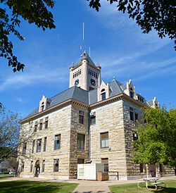
Mercer County is a county in Illinois. According to the 2020 census, it had a population of 15,699. [1] Its county seat is Aledo. [2]
Mercer County is included in the Davenport-Moline-Rock Island, IA-IL Metropolitan Statistical Area. [3]
Mercer County is named for Hugh Mercer (1726–1777), a physician and general during the American Revolution who died from wounds suffered at the Battle of Princeton.
In May 1812, Congress passed an act which set aside lands in Arkansas, Michigan, and Illinois as payment to volunteer soldiers in the War of 1812. Mercer County was part of this "Military Tract."
Seven years after Illinois became a state, Mercer County was founded. It was formed from unorganized territory near Pike County on January 13, 1825. Although the county had been created, its government was not organized for several years; for administration purposes it was attached first to Schuyler County (until 1826), then to Peoria (until 1831), and finally to Warren County. The organization of the county government was finally completed in 1835, after a large influx of settlers following the Black Hawk War. [4]
According to the U.S. Census Bureau, the county has a total area of 569 square miles (1,470 km2), of which 561 square miles (1,450 km2) is land and 7.5 square miles (19 km2) (1.3%) is water. [5]
Aledo, Illinois | ||||||||||||||||||||||||||||||||||||||||||||||||||||||||||||
---|---|---|---|---|---|---|---|---|---|---|---|---|---|---|---|---|---|---|---|---|---|---|---|---|---|---|---|---|---|---|---|---|---|---|---|---|---|---|---|---|---|---|---|---|---|---|---|---|---|---|---|---|---|---|---|---|---|---|---|---|
Climate chart (explanation) | ||||||||||||||||||||||||||||||||||||||||||||||||||||||||||||
| ||||||||||||||||||||||||||||||||||||||||||||||||||||||||||||
|
In recent years, average temperatures in the county seat of Aledo have ranged from a low of 11 °F (−12 °C) in January to a high of 84 °F (29 °C) in July, although a record low of −30 °F (−34 °C) was recorded in February 1905 and a record high of 113 °F (45 °C) was recorded in July 1936. Average monthly precipitation ranged from 1.27 inches (32 mm) in January to 4.43 inches (113 mm) in June. [6]
Census | Pop. | Note | %± |
---|---|---|---|
1830 | 26 | — | |
1840 | 2,352 | 8,946.2% | |
1850 | 5,246 | 123.0% | |
1860 | 15,042 | 186.7% | |
1870 | 18,769 | 24.8% | |
1880 | 19,502 | 3.9% | |
1890 | 18,545 | −4.9% | |
1900 | 20,945 | 12.9% | |
1910 | 19,723 | −5.8% | |
1920 | 18,800 | −4.7% | |
1930 | 16,641 | −11.5% | |
1940 | 17,701 | 6.4% | |
1950 | 17,374 | −1.8% | |
1960 | 17,149 | −1.3% | |
1970 | 17,294 | 0.8% | |
1980 | 19,286 | 11.5% | |
1990 | 17,290 | −10.3% | |
2000 | 16,957 | −1.9% | |
2010 | 16,434 | −3.1% | |
2020 | 15,699 | −4.5% | |
2023 (est.) | 15,487 | [7] | −1.4% |
U.S. Decennial Census [8] 1790-1960 [9] 1900-1990 [10] 1990-2000 [11] 2010 [12] |
As of the 2010 United States census, there were 16,434 people, 6,734 households, and 4,724 families residing in the county. [13] The population density was 29.3 inhabitants per square mile (11.3/km2). There were 7,358 housing units at an average density of 13.1 per square mile (5.1/km2). [5] The racial makeup of the county was 98.3% white, 0.3% black or African American, 0.3% Asian, 0.1% American Indian, 0.3% from other races, and 0.7% from two or more races. Those of Hispanic or Latino origin made up 1.9% of the population. [13] In terms of ancestry, 25.9% were German, 18.2% were Irish, 11.3% were English, 9.4% were Swedish, and 7.4% were American. [14]
Of the 6,734 households, 30.1% had children under the age of 18 living with them, 58.3% were married couples living together, 7.9% had a female householder with no husband present, 29.8% were non-families, and 25.8% of all households were made up of individuals. The average household size was 2.41 and the average family size was 2.88. The median age was 43.7 years. [13]
The median income for a household in the county was $50,909 and the median income for a family was $62,025. Males had a median income of $46,136 versus $30,392 for females. The per capita income for the county was $25,332. About 8.2% of families and 9.3% of the population were below the poverty line, including 14.9% of those under age 18 and 7.2% of those age 65 or over. [15]
Mercer County is divided into fifteen townships:
Historically, Mercer County was a solidly Republican Yankee-influenced county, and before the Republican Party existed a stronghold of the Whig Party. The county never voted for a Democratic presidential candidate until Lyndon Johnson’s 1964 landslide over Barry Goldwater – the solitary break in Whig and Republican dominance occurring in 1912 when the GOP was mortally split and Progressive Theodore Roosevelt carried the county over conservative incumbent President William Howard Taft. After Johnson’s victory in the county, Mercer voted to being Republican between 1968 and 1984, but Reagan’s landslide in that election saw a swing to the Democrats that was capitalized upon by Michael Dukakis to carry the county in 1988. Between then and 2012, Mercer was solidly Democratic, but concern over declining economic opportunities in the “Rust Belt” caused a dramatic swing to populist Republican Donald Trump in 2016. Trump’s performance was the best by a Republican since Richard Nixon's 3,000-plus-county landslide in 1972.
Mercer County is located in Illinois's 17th Congressional District and is currently represented by Democrat Cheri Bustos. Within the Illinois House of Representatives, the county is located in the 74th district and is currently represented by Republican Daniel Swanson. The county is located in the 37th district of the Illinois Senate, and is currently represented by Republican Chuck Weaver.
Year | Republican | Democratic | Third party(ies) | |||
---|---|---|---|---|---|---|
No. | % | No. | % | No. | % | |
2024 | 5,215 | 62.28% | 2,950 | 35.23% | 208 | 2.48% |
2020 | 5,418 | 60.78% | 3,280 | 36.80% | 216 | 2.42% |
2016 | 4,807 | 56.39% | 3,071 | 36.02% | 647 | 7.59% |
2012 | 3,876 | 45.24% | 4,507 | 52.60% | 185 | 2.16% |
2008 | 3,833 | 43.21% | 4,887 | 55.10% | 150 | 1.69% |
2004 | 4,405 | 49.09% | 4,512 | 50.28% | 57 | 0.64% |
2000 | 3,688 | 44.34% | 4,400 | 52.90% | 230 | 2.77% |
1996 | 2,688 | 34.04% | 4,278 | 54.17% | 931 | 11.79% |
1992 | 2,983 | 34.93% | 3,990 | 46.72% | 1,567 | 18.35% |
1988 | 3,683 | 46.45% | 4,204 | 53.02% | 42 | 0.53% |
1984 | 4,907 | 54.97% | 3,982 | 44.61% | 38 | 0.43% |
1980 | 5,144 | 56.18% | 3,361 | 36.71% | 651 | 7.11% |
1976 | 4,816 | 53.62% | 4,090 | 45.54% | 76 | 0.85% |
1972 | 5,452 | 60.98% | 3,477 | 38.89% | 11 | 0.12% |
1968 | 4,844 | 56.33% | 3,143 | 36.55% | 613 | 7.13% |
1964 | 4,220 | 48.90% | 4,410 | 51.10% | 0 | 0.00% |
1960 | 5,582 | 61.60% | 3,476 | 38.36% | 3 | 0.03% |
1956 | 5,732 | 65.82% | 2,969 | 34.10% | 7 | 0.08% |
1952 | 6,416 | 70.53% | 2,679 | 29.45% | 2 | 0.02% |
1948 | 5,267 | 62.55% | 3,117 | 37.02% | 36 | 0.43% |
1944 | 5,667 | 63.12% | 3,277 | 36.50% | 34 | 0.38% |
1940 | 6,336 | 62.09% | 3,830 | 37.53% | 38 | 0.37% |
1936 | 5,028 | 50.87% | 4,751 | 48.07% | 105 | 1.06% |
1932 | 4,436 | 50.21% | 4,309 | 48.77% | 90 | 1.02% |
1928 | 5,699 | 70.59% | 2,316 | 28.69% | 58 | 0.72% |
1924 | 5,618 | 68.30% | 1,699 | 20.66% | 908 | 11.04% |
1920 | 5,531 | 74.58% | 1,574 | 21.22% | 311 | 4.19% |
1916 | 5,308 | 58.93% | 3,430 | 38.08% | 270 | 3.00% |
1912 | 959 | 19.20% | 1,602 | 32.07% | 2,435 | 48.74% |
1908 | 2,871 | 57.51% | 1,777 | 35.60% | 344 | 6.89% |
1904 | 3,230 | 63.65% | 1,386 | 27.31% | 459 | 9.04% |
1900 | 3,304 | 59.39% | 2,110 | 37.93% | 149 | 2.68% |
1896 | 3,120 | 56.48% | 2,329 | 42.16% | 75 | 1.36% |
1892 | 2,470 | 52.70% | 1,975 | 42.14% | 242 | 5.16% |
Greenlee County is a county in the southeastern part of the U.S. state of Arizona. As of the 2020 census, the population was 9,563, making it Arizona's least populous county. The county seat is Clifton.
Mills County is a county located in the U.S. state of Iowa. As of the 2020 census, the population was 14,484. The county seat is Glenwood. The county was formed in 1851 and named for Major Frederick Mills of Burlington, Iowa, who was killed at the Battle of Churubusco during the Mexican–American War.
Des Moines County is located in the U.S. state of Iowa. As of the 2020 census, the population was 38,910. The county seat and largest city is Burlington. It is one of Iowa's two original counties along with Dubuque County; both were organized by the Michigan Territorial legislature in 1834. Des Moines County is part of the Burlington, IA–IL Micropolitan Statistical Area.
Warren County is a county in the U.S. state of Illinois. According to the 2020 census, it had a population of 16,835. Its county seat is Monmouth.
Schuyler County is a county in the U.S. state of Illinois. According to the 2020 census, it had a population of 6,902. Its county seat is Rushville.
Livingston County is a county located in the U.S. state of Illinois. According to the 2020 census, it has a population of 35,815. Its county seat is Pontiac. Livingston County comprises the Pontiac, IL Micropolitan Statistical Area, which is combined with the Bloomington–Normal metropolitan statistical area as the Bloomington-Pontiac, IL Combined Statistical Area in upper portion of Central Illinois.
Knox County is a county in the U.S. state of Illinois. According to the 2020 census, it had a population of 49,967. Its county seat is Galesburg.
Jefferson County is a county located in the southern part of the U.S. state of Illinois. According to the 2020 census, it has a population of 37,113. The county seat is Mount Vernon. Jefferson County contains the Mount Vernon, Illinois micropolitan area. It is located in the southern portion known locally as "Little Egypt". The western border of the county adjoins the Greater St. Louis consolidated metropolitan statistical area, the Metro-East region, and the St. Louis commuter region and market and viewing area.
Jasper County is a county located in the U.S. state of Illinois. According to the 2020 census, it has a population of 9,287. Its county seat is Newton.
Henderson County is a county located in the U.S. state of Illinois. According to the 2020 United States Census, it has a population of 6,387. Its county seat is Oquawka.
Christian County is a county located in the U.S. state of Illinois. As of the 2020 census, the population was 34,032. Its county seat is Taylorville.
Aledo is a city and the county seat of Mercer County, Illinois, United States. The population was 3,633 at the 2020 census.
Alexis is a village in Mercer and Warren counties in Illinois, United States. The population was 793 at the 2020 census.
Keithsburg is a city in Mercer County, Illinois, United States, on the Mississippi River. The population was 550 at the 2020 census, down from 609 in 2010. It was named for Robert Keith, a pioneer settler. Due to a flood in 1993, there isn’t much to do in Keithsburg. Some of the only things that are still in use today include, a bar/restaurant named “The Eagles Nest”, a gas station called “Casey’s”, and one or two playgrounds.
New Boston is a city in Mercer County, Illinois, United States on the Mississippi River. The population was 613 at the 2020 census, down from 683 in 2010.
North Henderson is a village in Mercer County, Illinois, United States. The population was 162 at the 2020 census.
Seaton is a village in Mercer County, Illinois, United States. The population was 214 at the 2020 census.
Sherrard is a village in Mercer County, Illinois, United States. The population was 692 at the 2020 census.
Viola is a village in Mercer County, Illinois, United States. The population was 869 at the 2020 census, a decline of 9 percent from 955 in 2010.
Windsor, also known as New Windsor, is a village in Rivoli Township, Mercer County, Illinois, United States. The population was 668 at the 2020 census, down from 748 in 2010. The official name is the "Village of Windsor", but "New Windsor" is the commonly used name, including by the New Windsor Fire Department and the US Postal Service.