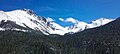
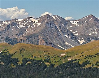
Nokhu Crags is a rock formation and mountain summit in the Never Summer Mountains range of the Rocky Mountains of North America. The name is derived from the Arapaho language, Neaha-no-xhu, meaning "Eagles Nest." The 12,490-foot (3,807 m) peak is located in State Forest State Park, 2.5 miles (4.0 km) south of Cameron Pass in Jackson County, Colorado, United States. The summit lies just northwest of the Continental Divide and Rocky Mountain National Park, near the headwaters of the Michigan River. The peak is prominently visible from State Highway 14 and can be seen throughout the southern North Park basin where it is known also known as "Sawtooth Mountain", "the Crags" or "Sleeping Indian" for its resemblance to the form of a supine chief. To the east lie the shallow basins of Snow Lake and the Michigan or American Lakes; to the north lies a snow filled couloir; to the west the mountain descends directly into the deep waters of Lake Agnes; and to the south lie Static Peak, Mount Richthofen, and the remainder of the Never Summer Mountain Range.
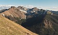
The Never Summer Mountains are a mountain range in the Rocky Mountains in north central Colorado in the United States consisting of over twenty named peaks. The range is located along the northwest border of Rocky Mountain National Park, forming an S-turn in the continental divide between the headwaters of the Colorado River in Rocky Mountain National Park and the upper basin of the North Platte River. The range is small and tall, covering only 25 sq mi (65 km2) with a north–south length of 10 mi (16 km) with over ten distinct peaks rising more than 12,000 ft (3,700 m). The range straddles the Jackson-Grand county line for most of its length, and stretches into Jackson and Larimer county at its northern end. A panoramic view of the range is available from sections of Trail Ridge Road in Rocky Mountain National Park. One of the northernmost peaks, Nokhu Crags, is prominently visible from the west side of Cameron Pass.

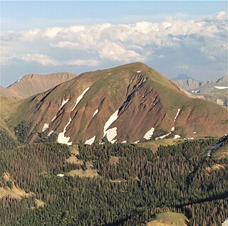
Braddock Peak is a mountain summit in the Never Summer Mountains range of the Rocky Mountains of North America. The 11,972-foot (3,649 m) peak is located in State Forest State Park, 3.0 miles (4.8 km) south-southwest of Cameron Pass in Jackson County, Colorado, United States.

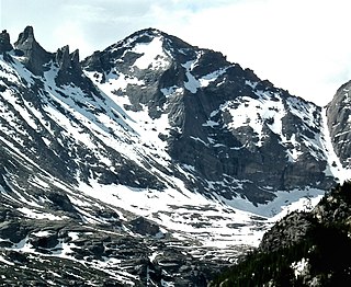
Mount Richthofen is the highest summit of the Never Summer Mountains range of the Rocky Mountains of North America. The prominent 12,945-foot (3,946 m) peak is located 5.6 miles (9.0 km) northwest by west of Milner Pass, Colorado, United States, on the Continental Divide separating the Rocky Mountain National Park Wilderness in Rocky Mountain National Park and Grand County from Routt National Forest and Jackson County. The mountain was named in honor of pioneering German geologist Baron Ferdinand von Richthofen, apparently by Clarence King's 1870 survey team.

Static Peak is a mountain peak in the U.S. state of Colorado, within State Forest State Park and part of the Never Summer Mountain Range. It is located in a chain of peaks and lies between Nokhu Crags to the north and Mount Richthofen to the south. To the east lie the shallow basins of Snow Lake and to the west the mountain descends directly into the deep waters of Lake Agnes.

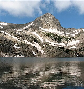
Lake Agnes is an alpine lake in the Colorado State Forest State Park occurring within the Never Summer Mountain Range. The lake lies within glacial tarn surrounded by a cirque consisting of Nokhu Crags, Static Peak, Mount Richthofen, Mount Mahler, and Braddock Peak. It is the deepest lake in the Colorado State Forest State Park. Lake Agnes is named after Agnes Zimmerman, the daughter of John Zimmerman, a homesteader in the area and the proprietor of the Keystone Hotel in Home, Colorado.

Mount Emma is a 13,581-foot-elevation (4,139-meter) mountain summit located in San Miguel County of Colorado, United States. It is situated three miles north of the community of Telluride, on the south side of Yankee Boy Basin, in the Uncompahgre National Forest. It is part of the Sneffels Range which is a subset of the San Juan Mountains, which in turn is part of the Rocky Mountains. Mount Emma is situated west of the Continental Divide, two miles south of Mount Sneffels, and 0.8 mile south of Gilpin Peak, the nearest higher neighbor. Emma ranks as the 197th-highest peak in Colorado, and the 10th-highest in the Sneffels Range. Topographic relief is significant as the south aspect rises 4,830 feet above Telluride in approximately three miles. An ascent of Mt. Emma is a difficult climb with 2,180 feet of elevation gain covering three miles from Yankee Boy Basin, or 4,836 feet of elevation gain from Telluride. This mountain's name was officially adopted by the U.S. Board on Geographic Names.
Mount Cirrus is a 12,808-foot-elevation (3,904-meter) mountain summit in Colorado, United States.

Mount Cumulus is a 12,729-foot-elevation (3,880-meter) mountain summit in Colorado, United States.
Mount Nimbus is a 12,721-foot-elevation (3,877-meter) mountain summit in Grand County, Colorado, United States.
Howard Mountain is a 12,826-foot-elevation (3,909-meter) summit in Colorado, United States.

Chiefs Head Peak is a 13,577-foot-elevation (4,138-meter) mountain summit in Boulder County, Colorado, United States.
Pagoda Mountain is a 13,497-foot-elevation (4,114-meter) mountain summit in Boulder County, Colorado, United States.

Mount Craig is a 12,007-foot-elevation (3,660-meter) mountain summit in Grand County, Colorado, United States.
Mount Stratus is a 12,534-foot-elevation (3,820-meter) mountain summit in Grand County, Colorado, United States.
Mount Toll is a 12,979-foot (3,956 m) mountain summit on the boundary shared by Boulder County and Grand County, in Colorado, United States.

Graystone Peak is a 13,489-foot-elevation (4,111-meter) mountain summit located in San Juan County, Colorado, United States.
Lulu Mountain is a 12,217-foot-elevation (3,724-meter) summit in Colorado, United States.

Parika Peak is a 12,402-foot-elevation (3,780-meter) mountain summit in Colorado, United States.

Green Knoll is a 12,297-foot-elevation (3,748-meter) mountain summit in Grand County, Colorado, United States.