
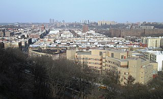
The Bronx is a borough of New York City, coextensive with Bronx County, in the U.S. state of New York. It is south of Westchester County; north and east of the New York City borough of Manhattan, across the Harlem River; and north of the New York City borough of Queens, across the East River. The Bronx has a land area of 42 square miles (109 km2) and a population of 1,472,654 in the 2020 census. If each borough were ranked as a city, the Bronx would rank as the ninth-most-populous in the U.S. Of the five boroughs, it has the fourth-largest area, fourth-highest population, and third-highest population density. The population density of the Bronx was 32,718.7 inhabitants per square mile (12,632.8/km2) in 2022, the third-highest population density of any county in the United States, behind Manhattan and Brooklyn. It is the only borough of New York City not primarily on an island. With a population that is 54.8% Hispanic as of 2020, it is the only majority-Hispanic county in the Northeastern United States and the fourth-most-populous nationwide.

Broadway is a road in the U.S. state of New York. Broadway runs from State Street at Bowling Green for 13 mi (20.9 km) through the borough of Manhattan and 2 mi (3.2 km) through the Bronx, exiting north from New York City to run an additional 18 mi (29.0 km) through the Westchester County municipalities of Yonkers, Hastings-On-Hudson, Dobbs Ferry, Irvington, Tarrytown, and Sleepy Hollow, after which the road continues, but is no longer called "Broadway".
Inwood is a neighborhood in the New York City borough of Manhattan, at the northern tip of Manhattan Island, in the U.S. state of New York. It is bounded by the Hudson River to the west, Spuyten Duyvil Creek and Marble Hill to the north, the Harlem River to the east, and Washington Heights to the south.

A vehicle registration plate, also known as a number plate or license plate, is a metal or plastic plate attached to a motor vehicle or trailer for official identification purposes. All countries require registration plates for road vehicles such as cars, trucks, and motorcycles. Whether they are required for other vehicles, such as bicycles, boats, or tractors, may vary by jurisdiction. The registration identifier is a numeric or alphanumeric ID that uniquely identifies the vehicle or vehicle owner within the issuing region's vehicle register. In some countries, the identifier is unique within the entire country, while in others it is unique within a state or province. Whether the identifier is associated with a vehicle or a person also varies by issuing agency. There are also electronic license plates.

Marble Hill is the northernmost neighborhood in the New York City borough of Manhattan. Although once part of Manhattan Island, it is now one of the few areas of Manhattan that are not located on the island. The Bronx surrounds the neighborhood to the west, north, and east. The area of Marble Hill was established as a Dutch colonial settlement in 1646, and gained its current name in 1891 from the Tuckahoe marble deposits discovered underneath the neighborhood.

Sixth Avenue – also known as Avenue of the Americas, although this name is seldom used by New Yorkers – is a major thoroughfare in New York City's borough of Manhattan, on which traffic runs northbound, or "uptown". It is commercial for much of its length.

New York City Subway nomenclature is the terminology used in the New York City Subway system as derived from railroading practice, historical origins of the system, and engineering, publicity, and legal usage. Important terms include lines, or individual sections of subway, like the BMT Brighton Line; services, like the B, which is a single train route along several lines; and stations, such as Coney Island–Stillwell Avenue, which connects multiple lines and services.

The Wall Street station is a station on the IRT Broadway–Seventh Avenue Line of the New York City Subway, located at the intersection of Wall Street and William Street in the Financial District of Manhattan. It is served by the 2 train at all times and the 3 train at all times except late nights.
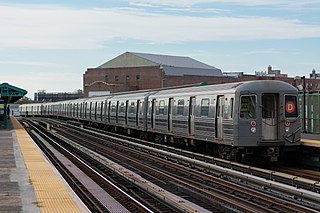
The D Sixth Avenue Express is a rapid transit service in the B Division of the New York City Subway. Its route emblem, or "bullet", is colored orange, since it uses the IND Sixth Avenue Line in Manhattan.

The Dyckman Street station is a station on the IND Eighth Avenue Line of the New York City Subway, located at the intersection of Dyckman Street and Broadway in Inwood, within northern Manhattan. It is served by the A train at all times.

The 145th Street station is a local station on the IRT Broadway–Seventh Avenue Line of the New York City Subway. Located at the intersection of Broadway and 145th Street in Hamilton Heights, Manhattan, it is served by the 1 train at all times.

The Marble Hill–225th Street station is a local station on the IRT Broadway–Seventh Avenue Line of the New York City Subway. Located at the intersection of Broadway and 225th Street in Marble Hill, Manhattan, it is served by the 1 train at all times.

A gang sign, also known as a gang signal, is a verbal or visual way gang members identify their affiliation. This can take many forms including slogans, hand signs, colored clothing and graffiti. The wearer usually favors, or is in, that particular gang. Many of these, especially slogans and hand signs, have become part of popular culture, especially in African American hip hop culture.

A street name sign is a type of traffic sign used to identify named roads, generally those that do not qualify as expressways or highways. Street name signs are most often found posted at intersections; sometimes, especially in the United States, in perpendicularly oriented pairs identifying each of the crossing streets.
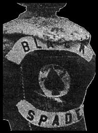
The Black Spades are a mostly African-American street gang which started in the Bronx during the late 1960s and gained popularity in the 1970s. The gang began to spread from the Bronx to Manhattan, Queens, Brooklyn, Staten Island, New Rochelle, New Jersey, Massachusetts and Connecticut by the late 1980s. During this period Latino and white members were more common. The Black Spades have made a comeback in 2019 with more members joining. They are now TBS New Direction, a community service group championing anti-violence initiatives and providing food distribution for the food insecure.

The Prince Street station is a local station on the BMT Broadway Line of the New York City Subway. Located in SoHo, Manhattan, it is served by the R train at all times except late nights, the W train on weekdays, the N train during late nights and weekends, and the Q train during late nights.

The Houston Street station is a local station on the IRT Broadway–Seventh Avenue Line of the New York City Subway. Located at West Houston and Varick Streets in Greenwich Village, Manhattan, it is served by the 1 train at all times and by the 2 train during late nights.
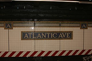
Many New York City Subway stations are decorated with colorful ceramic plaques and tile mosaics. Of these, many take the form of signs, identifying the station's location. Much of this ceramic work was in place when the subway system originally opened on October 27, 1904. Newer work continues to be installed each year, much of it cheerful and fanciful.

MTA Regional Bus Operations (RBO) is the surface transit division of the Metropolitan Transportation Authority (MTA). It was created in 2008 to consolidate all bus operations in New York City operated by the MTA. As of February 2018, MTA Regional Bus Operations runs 234 local routes, 71 express routes, and 20 Select Bus Service routes. Its fleet of 5,725 buses is the largest municipal bus fleet in the United States and operates 24/7. In 2022, the system had a ridership of 583,822,700, or about 2,153,200 per weekday as of the third quarter of 2023.

Street name signs in Chicago are green with white text. They are traditionally written in all capital letters, but newer signs can also be written with lowercase letters. All signs contain not only the name of the street, but also its directional position and abbreviated suffix. Larger signs, located at intersections with stoplights, also include the street's numerical position within Chicago's grid system.


